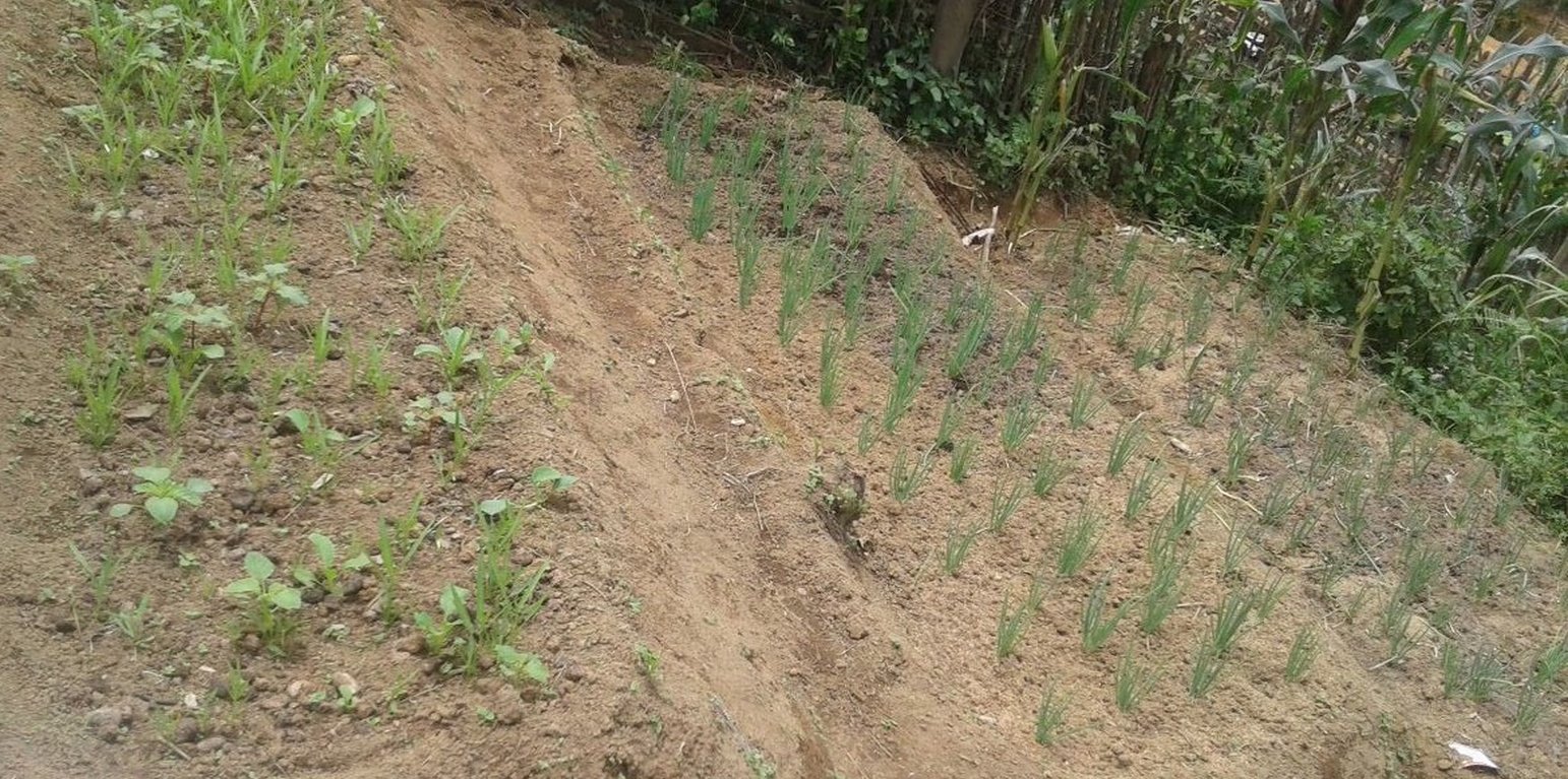
Vegetable home garden in sloping terrain (Khampheng Bounphanya)

Vegetable garden to improve vegetation cover in sloping land (Lao People's Democratic Republic)

Description

The technique involving the creation of vegetable home gardens on sloping land was initiated through the villagers’ local insight and it has been practiced over many generations. Due to the fact that the village is located on sloping land there are limitations regarding the availability of agricultural land suitable for growing vegetables in a home garden.

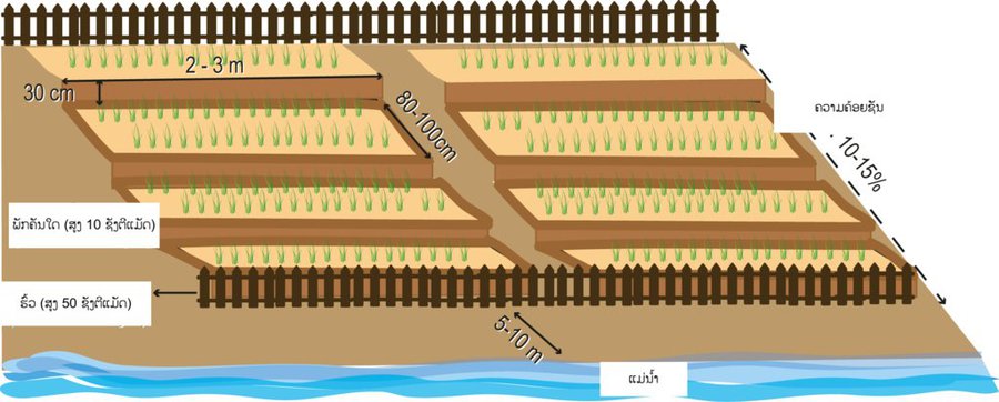
The local farmers mainly grow vegetables with other crops such as upland rice in upland areas and vegetable home gardens. In addition, they grow also vegetables along riverbanks during the dry season. Land users living on mountainous areas typically grow vegetables during the wet season and some manage to cultivate them during dry season if appropriate land is available along streams and river banks. Vegetables have traditionally been cultivated by farmers in Darkchung district on terraced fields for many generations. However, growing vegetables on areas of land with a higher gradient (rolling slopes: 11-15%) has a number of restrictions, namely the lack of suitable land available and the limited water supply. As a result of these restrictions on land and water farmers have developed their own initiatives to enable the cultivation of vegetables on sloping land both for household consumption and for sale. The vegetables most commonly grown are coriander, morning glory, and Chinese cabbage and mustard leaf. In 2000 farmers expanded their vegetable gardens on slopes by preparing and cultivating the land manually. Suitable land for such vegetable gardens can be selected along the lower banks of a stream (there should be a distance of approximately 5 – 10 meters from the river to the vegetable plots). Firstly, grass has to be removed prior to ploughing the soil manually. Then the soil from the top part of the land should be transferred to the bottom to result in a levelling effect so that a relatively flat garden bed is created. The preparation process to develop the whole garden takes about 3 – 4 weeks and requires a team of two to three people. In the preparation process there is a distinctive drawback when the farmers remove the humus and topsoil from the upper section of the field and leave the less fertile subsoil behind. As a result, this might affect the productivity during the early stage of vegetable growth; and on the contrary the lower sections piled with nutritious topsoil from the upper parts become more suitable for plant growth. To solve this problem, the farmers shape and level the nutrient-rich topsoil up to 3-4 small terraces top down. On average, with an area of 0.01ha such vegetable fields in Darkchung district are divided into small terraces with a width of 60 – 80 centimetres and a length of 2 – 3 metres (about 7 – 8 terraced plots per household, mostly two terrace arrangements in parallel). There is approximately a 30 cm difference between the levels of the upper to the next lower vegetable terrace. Once the land levelling has been completed, the farmers are then able to prepare the plots by firstly ploughing the soil and then letting it dry for 5 – 7 days. The next stage involves the use of wooden poles to break down bigger clods of earth. Then a small earth dike (10cm in hight) is pilled up around each terrace to protect furhter against soil erosion by water. Before starting the vegetable cultivation fencing is needed against animal entry. After this, they use a rake to adjust the plot’s surface. The benefits of this terracing method is to extend the cultivation of vegetables on stream river banks for the household consumption. Futhermore, the terracing method and the better soil cover lead to protection of the stream banks from erosion and sediment transport. However, this technique have some constraints as well beause it is difficult to level the surface of the soil in these areas particularly by removing soil from the upper sections to the lower sections of the terraces.

Location

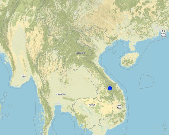
Location: Darkchung district, Xekong province, Lao People's Democratic Republic

No. of Technology sites analysed: 2-10 sites

Geo-reference of selected sites
  • 107.21293, 15.63056

Spread of the Technology: evenly spread over an area (approx. < 0.1 km2 (10 ha))

In a permanently protected area?:

Date of implementation: 10-50 years ago

Type of introduction

Classification of the Technology

Main purpose
  • improve production
  • reduce, prevent, restore land degradation
  • conserve ecosystem
  • protect a watershed/ downstream areas – in combination with other Technologies
  • preserve/ improve biodiversity
  • reduce risk of disasters
  • adapt to climate change/ extremes and its impacts
  • mitigate climate change and its impacts
  • create beneficial economic impact
  • create beneficial social impact
Land use

  • Cropland
    • Annual cropping: seed crops - sesame, poppy, mustard, other, vegetables - leafy vegetables (salads, cabbage, spinach, other)
    Number of growing seasons per year: 3

Water supply
  • rainfed
  • mixed rainfed-irrigated
  • full irrigation
  • Water from stream

Purpose related to land degradation
  • prevent land degradation
  • reduce land degradation
  • restore/ rehabilitate severely degraded land
  • adapt to land degradation
  • not applicable
Degradation addressed
  • soil erosion by water - Wt: loss of topsoil/ surface erosion, Wg: gully erosion/ gullying
  • biological degradation - Bc: reduction of vegetation cover
SLM group
  • improved ground/ vegetation cover
  • cross-slope measure
  • home gardens
SLM measures
  • agronomic measures - A1: Vegetation/ soil cover
  • structural measures - S1: Terraces

Technical drawing

Technical specifications
The average gradient for vegetable cultivation in terrain ranges from 10 – 15% and the distance from the stream to the vegetable plots is approximately 5 metres. The width of the average plot is about 80 – 100 cm, and the length is 2 -3 metres with the difference in height between the upper and the next lower terrace is about 30 cm. Fencing around the vegetable plot is needed to prevent damages done by animals (goats, cows etc.)
Author: U.Gaemperli

Establishment and maintenance: activities, inputs and costs

Calculation of inputs and costs
  • Costs are calculated: per Technology area (size and area unit: 200 Square meters; conversion factor to one hectare: 1 ha = 0,02 Hectare)
  • Currency used for cost calculation: LAK
  • Exchange rate (to USD): 1 USD = 8000.0 LAK
  • Average wage cost of hired labour per day: 30000
Most important factors affecting the costs
The labour for land levelling is the most important factor affecting the costs.
Establishment activities
  1. Land preparation (ploughing and levelling into terraces) (Timing/ frequency: Before rainy season)
  2. Fencing (Timing/ frequency: Before vegetable planting)
Establishment inputs and costs (per 200 Square meters)
Specify input Unit Quantity Costs per Unit (LAK) Total costs per input (LAK) % of costs borne by land users
Labour
Labour for land ploughing and levelling person day 21.0 30000.0 630000.0 100.0
Labour for fencing person day 4.0 30000.0 120000.0 100.0
Equipment
Shovel piece 2.0 100000.0 200000.0 100.0
Digger tool piece 2.0 100000.0 200000.0 100.0
Construction material
Nails kg 2.0 10000.0 20000.0 100.0
Wire roll 2.0 60000.0 120000.0 100.0
Wooden posts piece 80.0 5000.0 400000.0 100.0
Wooden plank piece 20.0 5000.0 100000.0 100.0
Bamboo piece 300.0 2000.0 600000.0 100.0
Total costs for establishment of the Technology 2'390'000.0
Total costs for establishment of the Technology in USD 298.75
Maintenance activities
  1. Reshaping of the the terraces (maintenance of terraces) (Timing/ frequency: After harvesting)
  2. Planting of seedling (Timing/ frequency: After land preparation)
  3. Weeding (Timing/ frequency: From time to time)
  4. Manure (Timing/ frequency: From time to time)
Maintenance inputs and costs (per 200 Square meters)
Specify input Unit Quantity Costs per Unit (LAK) Total costs per input (LAK) % of costs borne by land users
Labour
Labour for re-levelling the terraces person day 4.0 30000.0 120000.0 100.0
Labour for weeding person day 3.0 30000.0 90000.0 100.0
Labour to apply manure person day 1.0 30000.0 30000.0 100.0
Labour for planting person day 3.0 30000.0 90000.0 100.0
Plant material
Seedling bag 4.0 5000.0 20000.0 100.0
Fertilizers and biocides
Manure kg 30.0 5000.0 150000.0 100.0
Total costs for maintenance of the Technology 500'000.0
Total costs for maintenance of the Technology in USD 62.5

Natural environment

Average annual rainfall
  • < 250 mm
  • 251-500 mm
  • 501-750 mm
  • 751-1,000 mm
  • 1,001-1,500 mm
  • 1,501-2,000 mm
  • 2,001-3,000 mm
  • 3,001-4,000 mm
  • > 4,000 mm
Agro-climatic zone
  • humid
  • sub-humid
  • semi-arid
  • arid
Specifications on climate
Name of the meteorological station: Darkchung meteorological station
Slope
  • flat (0-2%)
  • gentle (3-5%)
  • moderate (6-10%)
  • rolling (11-15%)
  • hilly (16-30%)
  • steep (31-60%)
  • very steep (>60%)
Landforms
  • plateau/plains
  • ridges
  • mountain slopes
  • hill slopes
  • footslopes
  • valley floors
Altitude
  • 0-100 m a.s.l.
  • 101-500 m a.s.l.
  • 501-1,000 m a.s.l.
  • 1,001-1,500 m a.s.l.
  • 1,501-2,000 m a.s.l.
  • 2,001-2,500 m a.s.l.
  • 2,501-3,000 m a.s.l.
  • 3,001-4,000 m a.s.l.
  • > 4,000 m a.s.l.
Technology is applied in
  • convex situations
  • concave situations
  • not relevant
Soil depth
  • very shallow (0-20 cm)
  • shallow (21-50 cm)
  • moderately deep (51-80 cm)
  • deep (81-120 cm)
  • very deep (> 120 cm)
Soil texture (topsoil)
  • coarse/ light (sandy)
  • medium (loamy, silty)
  • fine/ heavy (clay)
Soil texture (> 20 cm below surface)
  • coarse/ light (sandy)
  • medium (loamy, silty)
  • fine/ heavy (clay)
Topsoil organic matter content
  • high (>3%)
  • medium (1-3%)
  • low (<1%)
Groundwater table
  • on surface
  • < 5 m
  • 5-50 m
  • > 50 m
Availability of surface water
  • excess
  • good
  • medium
  • poor/ none
Water quality (untreated)
  • good drinking water
  • poor drinking water (treatment required)
  • for agricultural use only (irrigation)
  • unusable
Water quality refers to:
Is salinity a problem?
  • Yes
  • No

Occurrence of flooding
  • Yes
  • No
Species diversity
  • high
  • medium
  • low
Habitat diversity
  • high
  • medium
  • low

Characteristics of land users applying the Technology

Market orientation
  • subsistence (self-supply)
  • mixed (subsistence/ commercial)
  • commercial/ market
Off-farm income
  • less than 10% of all income
  • 10-50% of all income
  • > 50% of all income
Relative level of wealth
  • very poor
  • poor
  • average
  • rich
  • very rich
Level of mechanization
  • manual work
  • animal traction
  • mechanized/ motorized
Sedentary or nomadic
  • Sedentary
  • Semi-nomadic
  • Nomadic
Individuals or groups
  • individual/ household
  • groups/ community
  • cooperative
  • employee (company, government)
Gender
  • women
  • men
Age
  • children
  • youth
  • middle-aged
  • elderly
Area used per household
  • < 0.5 ha
  • 0.5-1 ha
  • 1-2 ha
  • 2-5 ha
  • 5-15 ha
  • 15-50 ha
  • 50-100 ha
  • 100-500 ha
  • 500-1,000 ha
  • 1,000-10,000 ha
  • > 10,000 ha
Scale
  • small-scale
  • medium-scale
  • large-scale
Land ownership
  • state
  • company
  • communal/ village
  • group
  • individual, not titled
  • individual, titled
Land use rights
  • open access (unorganized)
  • communal (organized)
  • leased
  • individual
Water use rights
  • open access (unorganized)
  • communal (organized)
  • leased
  • individual
Access to services and infrastructure
health

poor
good
education

poor
good
technical assistance

poor
good
employment (e.g. off-farm)

poor
good
markets

poor
good
energy

poor
good
roads and transport

poor
good
drinking water and sanitation

poor
good
financial services

poor
good

Impacts

Socio-economic impacts
Crop production
decreased
increased


Increase crop production

risk of production failure
increased
decreased


Lower risk of flooding compared to other areas of vegetable gardens located in the lower plains.

product diversity
decreased
increased


Increase and diversification of vegetable production from their own vegetable home gardens due to enlargement of production area.

production area (new land under cultivation/ use)
decreased
increased

Quantity before SLM: 0.02 ha
Quantity after SLM: 0.04 ha

land management
hindered
simplified


As the land users use sloping land on river banks nearer to the village by shaping the land into terraces the land management for vegetable gardens has been simplified compared to the collection of wild vegetable on sloping forest area far away from the village.

farm income
decreased
increased


Before the farmers mainly produced for their home consumption. After: The vegetable production increased substantially to a level it can be also sold at the local market.

diversity of income sources
decreased
increased


The new option to sell vegetables at the local market diversified the income sources.

workload
increased
decreased


Workload decreased mainly for women as they do not have to spent time anymore to collect wild vegetables in the broad upland forest.

Socio-cultural impacts
situation of socially and economically disadvantaged groups (gender, age, status, ehtnicity etc.)
worsened
improved


Women benefit from this technology and it reduces the women's workload to collect vegetable from forest.

Ecological impacts
soil loss
increased
decreased


Protect stream banks from soil erosion by rain water.

vegetation cover
decreased
increased


Increased vegetation cover by the vegetable plantation. Before it was fallow covered with scarce grass vegetation.

Off-site impacts
buffering/ filtering capacity (by soil, vegetation, wetlands)
reduced
improved


Less sediment transportation due to improved vegetation cover in the slope areas of the river banks.

Cost-benefit analysis

Benefits compared with establishment costs
Short-term returns
very negative
very positive

Long-term returns
very negative
very positive

Benefits compared with maintenance costs
Short-term returns
very negative
very positive

Long-term returns
very negative
very positive

Climate change

-

Adoption and adaptation

Percentage of land users in the area who have adopted the Technology
  • single cases/ experimental
  • 1-10%
  • 11-50%
  • > 50%
Of all those who have adopted the Technology, how many have done so without receiving material incentives?
  • 0-10%
  • 11-50%
  • 51-90%
  • 91-100%
Has the Technology been modified recently to adapt to changing conditions?
  • Yes
  • No
To which changing conditions?
  • climatic change/ extremes
  • changing markets
  • labour availability (e.g. due to migration)

Conclusions and lessons learnt

Strengths: land user's view
  • Lower risk of flooding in relation to other vegetable fields which are located in the lower plains.
  • Vegetable cultivation generates an income as well as provides food for farmers.
  • Gardening is an activity which women can actively and fully become involved in as it can be implemented in the village.
Strengths: compiler’s or other key resource person’s view
Weaknesses/ disadvantages/ risks: land user's viewhow to overcome
  • Vegetables require fertilizers to improve the yield. Farmers also need to collect timber as building material to support the earth terraces so that fertilizer can be retained within the field.
  • Establishing and maintaining vegetable production is time consuming as it includes a number of activities such as land levelling, fertilizing, and the construction of fencing to prevent animal entry. It also requires other equipment and tools for fencing.
  • Suitable land is limited due to mountainous terrains.
Weaknesses/ disadvantages/ risks: compiler’s or other key resource person’s viewhow to overcome
  • The site selection for establishment. This technique will establish in slopes area (less than 15% of slop) and the plots are located approximately 5 meters from the river/stream in order to avoid soil erosion.
  • Land preparation and land levelling – farmers mainly remove top soil from upper to lower section to level the plots. People will remove soil from the upper to the lower sections of the plots in order to level them. Topsoil may have to be temporarily stockpiled somewhere so that it can be used as backfill where it is needed as the topsoil is more fertile and thus more productive.

References

Compiler
  • Khampheng Bounpanya
Editors
  • Bounthanom Bouahom
  • kang phanvongsa
  • anousit namsena
Reviewer
  • Nicole Harari
  • Nivong Sipaseuth
  • Stephanie Jaquet
  • Alexandra Gavilano
Date of documentation: Aug. 21, 2017
Last update: May 10, 2019
Resource persons
Full description in the WOCAT database
Linked SLM data
Documentation was faciliated by
Institution Project
This work is licensed under Creative Commons Attribution-NonCommercial-ShareaAlike 4.0 International