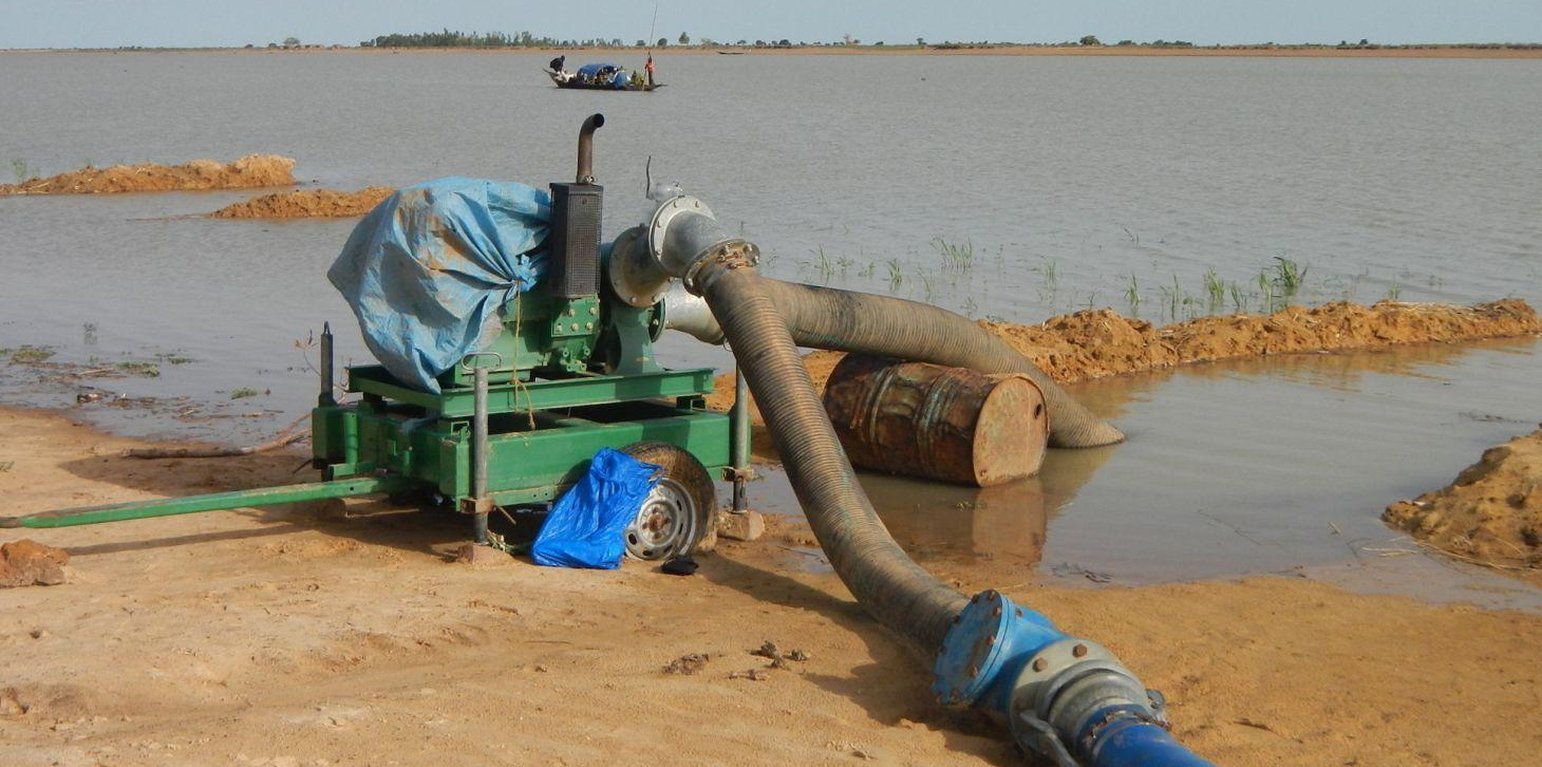
Pump unit (PMN/IPRODI)

Village irrigation schemes developed using the PMN/IPRODI approach (Mali)

Périmètres irrigués villageois type PMN/IPRODI (French)

Description

Village irrigation schemes (VISs) help to control the water supply and significantly increase yields.

Village irrigation schemes (VISs) are a concept and a development typology created in the 1970s and 80s. Using a relatively simple development concept, it was possible to create production units that were built and managed by local people in areas seriously affected by drought and a sharp decline in inundation events in the 1970s and 80s. Instead of being dependent on food aid, local people operating a VIS were able to guarantee sufficient rice production to cover their village’s food needs. With one pumping facility and one canal network installed, it is possible to control the water supply for an area of at least 20 hectares, thus creating the required conditions for intensive rice growing.

Prior to the installation of the scheme, the sites are not suitable for rice growing. Yields significantly increase as a result of the work carried out. An average harvest of six tonnes per hectare increases incomes. With an average price of 125 CFA francs per kilo of paddy, the rate of sales reaches 750,000 CFA francs per hectare. The surplus per hectare is estimated at 300,000 CFA francs.

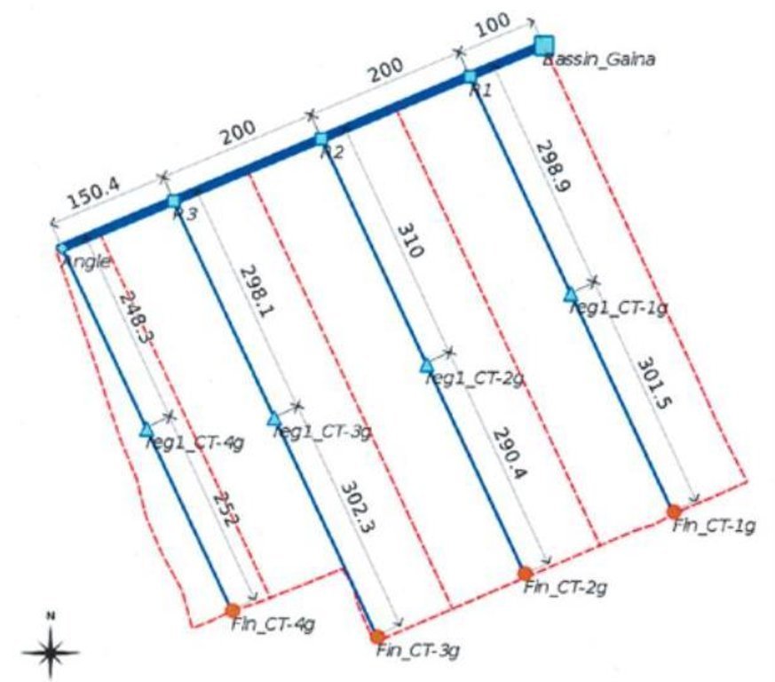
A VIS comprises a pumping station, small-scale facilities infrastructure, and irrigation and drainage networks. The pumping station consists of a pump unit fitted with a diesel motor with two or three 28 to 38 horse-power cylinders and a centrifugal pump with a capacity of 350 to 480 cubic metres per hour. The pump is positioned right alongside the water source (river, lake) and is mounted on a mobile chassis so it can be repositioned as and when required
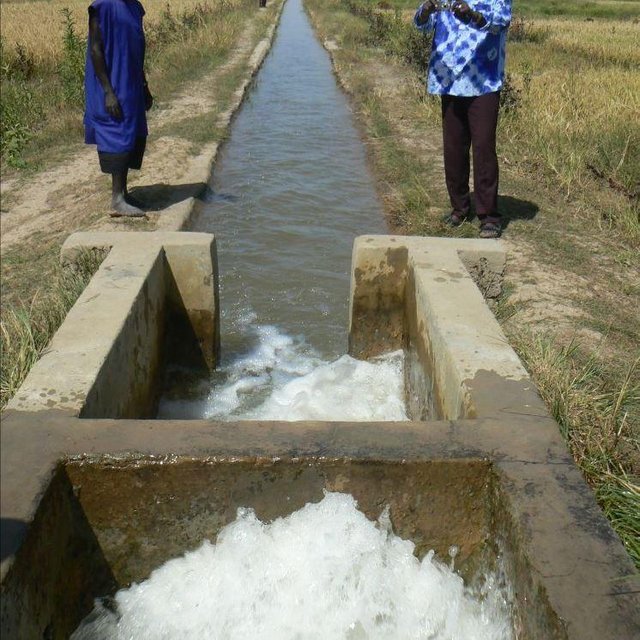
and depending on the situation of the water source, which can vary considerably during the winter growing season. At the end of the growing season, the pump unit can be stored in a secure, weather-proof location (out of the sun, rain, etc.). Water is then pumped through a flexible hose of reinforced polyethylene (the lengths generally being multiples of 50 metres, but no longer than 150 metres) up into the delivery basin where the energy carried in the turbulent pumped water is dissipated to prevent erosion damage and where the flow is calmed from turbulent to laminar. From the delivery basin onwards, the system makes use of gravity to feed its open canal network. The majority of the network is comprised of earthen structures, with only a section of the main canal being lined (usually a length of between 150 to 300 metres leading from the delivery basin outflow). The secondary and/or tertiary canals are supplied with water through a division box that apportions supply using a system of (‘all or nothing’) gates. Plots are watered from the tertiary canal by turning on the PVC hose.
Initially, villagers are able to express their need for a VIS through a village diagnostic exercise. This installation request is then taken up by the communes’ PDESC. A formal request is then referred to the mayor and drawn up by the community. The support structure (PMN/IPRODI) reviews the request and carries out a preliminary feasibility study. Decisions are then taken in a planning workshop on which schemes to prioritise. Following this, private planning consultants are commissioned to conduct feasibility studies. In parallel, technical and financial analyses are carried out by the programme’s planners, who also validate the studies. A meeting is held to inform and raise the awareness of the beneficiary communities about the development approach. The community is then requested to contribute their labour as part of the HLIW measures. The financial contribution required for the pump unit is up to 30% of its cost.

Farming a VIS (intensive rice growing) is fundamentally different to other, more traditional production systems to which farmers are accustomed (extensive rice growing in floodplains and millet growing in non-flooded areas). VISs require the purchase of inputs and the sale of at least part of the produce. Farming a VIS requires the development and good functioning of a value chain with many more links upstream and downstream of production and beyond the confines of the village than would be found in a traditional system. Although the VIS was initially conceived as a drought response mechanism in the 1970 and 80s, VIS farming encourages farmers to become more integrated in the rural and regional economy.

Location

Location: Mopti, Timbuktu, Mali, Mali

No. of Technology sites analysed:

Geo-reference of selected sites
  • n.a.

Spread of the Technology:

In a permanently protected area?:

Date of implementation: 10-50 years ago

Type of introduction
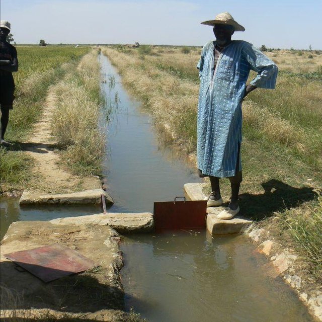
Division box (PMN/IPRODI)
Delivery basin (PMN/IPRODI)

Classification of the Technology

Main purpose
  • improve production
  • reduce, prevent, restore land degradation
  • conserve ecosystem
  • protect a watershed/ downstream areas – in combination with other Technologies
  • preserve/ improve biodiversity
  • reduce risk of disasters
  • adapt to climate change/ extremes and its impacts
  • mitigate climate change and its impacts
  • create beneficial economic impact
  • create beneficial social impact
Land use
Land use mixed within the same land unit: Yes - Agro-pastoralism (incl. integrated crop-livestock)

  • Cropland
    • Annual cropping
    Number of growing seasons per year: 1
  • Grazing land
Water supply
  • rainfed
  • mixed rainfed-irrigated
  • full irrigation

Purpose related to land degradation
  • prevent land degradation
  • reduce land degradation
  • restore/ rehabilitate severely degraded land
  • adapt to land degradation
  • not applicable
Degradation addressed
  • water degradation - Ha: aridification
SLM group
  • irrigation management (incl. water supply, drainage)
  • water diversion and drainage
  • surface water management (spring, river, lakes, sea)
SLM measures
  • management measures - M7: Others

Technical drawing

Technical specifications
Layout plan of the irrigation network (in blue) and the drainage network (in red)

Technical knowledge required for field staff / advisors: high
Technical knowledge required for land users: moderate
Main technical functions: increase / maintain water stored in soil, water harvesting / increase water supply, promotion of vegetation species and varieties (quality, eg palatable fodder)
Author: PMN/IPRODI

Establishment and maintenance: activities, inputs and costs

Calculation of inputs and costs
  • Costs are calculated:
  • Currency used for cost calculation: CFA Franc
  • Exchange rate (to USD): 1 USD = 517.0 CFA Franc
  • Average wage cost of hired labour per day: n.a
Most important factors affecting the costs
The development costs are estimated at 1.3 million CFA francs per hectare (2,497 Dollar). On the technical side, numerous scheme configurations have been observed. The most common involves a limited number of small-scale distribution control structures and a network of open, earthen canals. This type of scheme requires an investment in the order of between 1 and 1.5 million CFA francs per hectare. It also fosters the large-scale participation of villagers in all the building works, particularly excavation work and the installation of plots. At the other end of the spectrum are the VISs that have lined canals throughout their entire irrigation network. These require much more substantial investment (up to 7 or 8 million CFA francs per hectare) and building works (including plot installation) are generally carried out by contractors. As yet, no study has indicated that the yields and technical lifespan of such high-cost ‘sophisticated’ schemes are greater than those of ‘basic’ schemes.
Establishment activities
  1. formal request for irrigation scheme (Timing/ frequency: None)
  2. support structure (PMN/IPRODI) reviews the request and carries out a preliminary feasibility study (Timing/ frequency: None)
  3. Decisions are then taken in a planning workshop on which schemes to prioritise (Timing/ frequency: None)
  4. private planning consultants are commissioned to conduct feasibility studies (Timing/ frequency: None)
  5. In parallel, technical and financial analyses are carried out by the programme’s planners (Timing/ frequency: None)
  6. meeting is held to inform and raise the awareness of the beneficiary communities about the development approach (Timing/ frequency: None)
  7. community is then requested to contribute their labour (Timing/ frequency: None)
Establishment inputs and costs
Specify input Unit Quantity Costs per Unit (CFA Franc) Total costs per input (CFA Franc) % of costs borne by land users
Other
total construction ha 1.0 2497.0 2497.0 100.0
Total costs for establishment of the Technology 2'497.0
Total costs for establishment of the Technology in USD 4.83
Maintenance activities
  1. Regularly maintaining the facilities and networks (Timing/ frequency: None)
  2. Agricultural advisory support and monitoring of crops by the technical services (Timing/ frequency: None)

Natural environment

Average annual rainfall
  • < 250 mm
  • 251-500 mm
  • 501-750 mm
  • 751-1,000 mm
  • 1,001-1,500 mm
  • 1,501-2,000 mm
  • 2,001-3,000 mm
  • 3,001-4,000 mm
  • > 4,000 mm
Agro-climatic zone
  • humid
  • sub-humid
  • semi-arid
  • arid
Specifications on climate
Thermal climate class: tropics
Slope
  • flat (0-2%)
  • gentle (3-5%)
  • moderate (6-10%)
  • rolling (11-15%)
  • hilly (16-30%)
  • steep (31-60%)
  • very steep (>60%)
Landforms
  • plateau/plains
  • ridges
  • mountain slopes
  • hill slopes
  • footslopes
  • valley floors
Altitude
  • 0-100 m a.s.l.
  • 101-500 m a.s.l.
  • 501-1,000 m a.s.l.
  • 1,001-1,500 m a.s.l.
  • 1,501-2,000 m a.s.l.
  • 2,001-2,500 m a.s.l.
  • 2,501-3,000 m a.s.l.
  • 3,001-4,000 m a.s.l.
  • > 4,000 m a.s.l.
Technology is applied in
  • convex situations
  • concave situations
  • not relevant
Soil depth
  • very shallow (0-20 cm)
  • shallow (21-50 cm)
  • moderately deep (51-80 cm)
  • deep (81-120 cm)
  • very deep (> 120 cm)
Soil texture (topsoil)
  • coarse/ light (sandy)
  • medium (loamy, silty)
  • fine/ heavy (clay)
Soil texture (> 20 cm below surface)
  • coarse/ light (sandy)
  • medium (loamy, silty)
  • fine/ heavy (clay)
Topsoil organic matter content
  • high (>3%)
  • medium (1-3%)
  • low (<1%)
Groundwater table
  • on surface
  • < 5 m
  • 5-50 m
  • > 50 m
Availability of surface water
  • excess
  • good
  • medium
  • poor/ none
Water quality (untreated)
  • good drinking water
  • poor drinking water (treatment required)
  • for agricultural use only (irrigation)
  • unusable
Water quality refers to:
Is salinity a problem?
  • Yes
  • No

Occurrence of flooding
  • Yes
  • No
Species diversity
  • high
  • medium
  • low
Habitat diversity
  • high
  • medium
  • low

Characteristics of land users applying the Technology

Market orientation
  • subsistence (self-supply)
  • mixed (subsistence/ commercial)
  • commercial/ market
Off-farm income
  • less than 10% of all income
  • 10-50% of all income
  • > 50% of all income
Relative level of wealth
  • very poor
  • poor
  • average
  • rich
  • very rich
Level of mechanization
  • manual work
  • animal traction
  • mechanized/ motorized
Sedentary or nomadic
  • Sedentary
  • Semi-nomadic
  • Nomadic
Individuals or groups
  • individual/ household
  • groups/ community
  • cooperative
  • employee (company, government)
Gender
  • women
  • men
Age
  • children
  • youth
  • middle-aged
  • elderly
Area used per household
  • < 0.5 ha
  • 0.5-1 ha
  • 1-2 ha
  • 2-5 ha
  • 5-15 ha
  • 15-50 ha
  • 50-100 ha
  • 100-500 ha
  • 500-1,000 ha
  • 1,000-10,000 ha
  • > 10,000 ha
Scale
  • small-scale
  • medium-scale
  • large-scale
Land ownership
  • state
  • company
  • communal/ village
  • group
  • individual, not titled
  • individual, titled
Land use rights
  • open access (unorganized)
  • communal (organized)
  • leased
  • individual
Water use rights
  • open access (unorganized)
  • communal (organized)
  • leased
  • individual
Access to services and infrastructure
health

poor
x
good
education

poor
x
good
technical assistance

poor
x
good
employment (e.g. off-farm)

poor
x
good
markets

poor
x
good
energy

poor
x
good
roads and transport

poor
x
good
drinking water and sanitation

poor
x
good
financial services

poor
x
good

Impacts

Socio-economic impacts
Crop production
decreased
x
increased

risk of production failure
increased
x
decreased

product diversity
decreased
x
increased

production area (new land under cultivation/ use)
decreased
x
increased

farm income
decreased
x
increased

diversity of income sources
decreased
x
increased

Socio-cultural impacts
food security/ self-sufficiency
reduced
x
improved

community institutions
weakened
x
strengthened

contribution to human well-being
decreased
x
increased


Instead of being dependent on food aid, local people operating a VIS are able to guarantee sufficient rice production to cover their village’s food needs.

Ecological impacts
water quantity
decreased
x
increased

harvesting/ collection of water (runoff, dew, snow, etc)
reduced
x
improved

groundwater table/ aquifer
lowered
x
recharge

soil moisture
decreased
x
increased

Off-site impacts

Cost-benefit analysis

Benefits compared with establishment costs
Short-term returns
very negative
x
very positive

Long-term returns
very negative
x
very positive

Benefits compared with maintenance costs
Short-term returns
very negative
x
very positive

Long-term returns
very negative
x
very positive

Climate change

Gradual climate change
annual temperature increase

not well at all
x
very well
Climate-related extremes (disasters)
local rainstorm

not well at all
x
very well
local windstorm

not well at all
x
very well
drought

not well at all
x
very well
general (river) flood

not well at all
x
very well
Other climate-related consequences
reduced growing period

not well at all
x
very well

Adoption and adaptation

Percentage of land users in the area who have adopted the Technology
  • single cases/ experimental
  • 1-10%
  • 11-50%
  • > 50%
Of all those who have adopted the Technology, how many have done so without receiving material incentives?
  • 0-10%
  • 11-50%
  • 51-90%
  • 91-100%
Has the Technology been modified recently to adapt to changing conditions?
  • Yes
  • No
To which changing conditions?
  • climatic change/ extremes
  • changing markets
  • labour availability (e.g. due to migration)

Conclusions and lessons learnt

Strengths: land user's view
  • Option for scheme extensions to be undertaken by the beneficiaries themselves
Strengths: compiler’s or other key resource person’s view
  • Yields significantly increase
  • Building more sustainable and less costly schemes through the careful configuration of irrigation canals
  • Low investment costs
  • Existence of 15-year-old schemes that are still productive and in good condition
  • Possibility for beneficiaries to replace spent pump units using their own savings
Weaknesses/ disadvantages/ risks: land user's viewhow to overcome
Weaknesses/ disadvantages/ risks: compiler’s or other key resource person’s viewhow to overcome
  • scheme areas may become a source of conflict

References

Compiler
  • Dieter Nill
Editors
Reviewer
  • Deborah Niggli
  • Alexandra Gavilano
Date of documentation: Sept. 24, 2014
Last update: May 27, 2019
Resource persons
Full description in the WOCAT database
Linked SLM data
Documentation was faciliated by
Institution Project
Key references
  • Manual of Good Practices in Small Scale Irrigation in the Sahel. Experiences from Mali. Published by GIZ in 2014.: http://star-www.giz.de/starweb/giz/pub/servlet.starweb
  • IPRODI (2009): Approche du PMN pour le développement de l’irrigation de proximité, region de Tombouctou [North Mali Programme’s approach to developing small-scale irrigation in the Timbuktu region].:
This work is licensed under Creative Commons Attribution-NonCommercial-ShareaAlike 4.0 International