Flood Irrigation for salinity control
(Oman)
التحكم في الملوحة باستخدام ري بالغمر
Description
Using saline ground water for controlling soil salinity
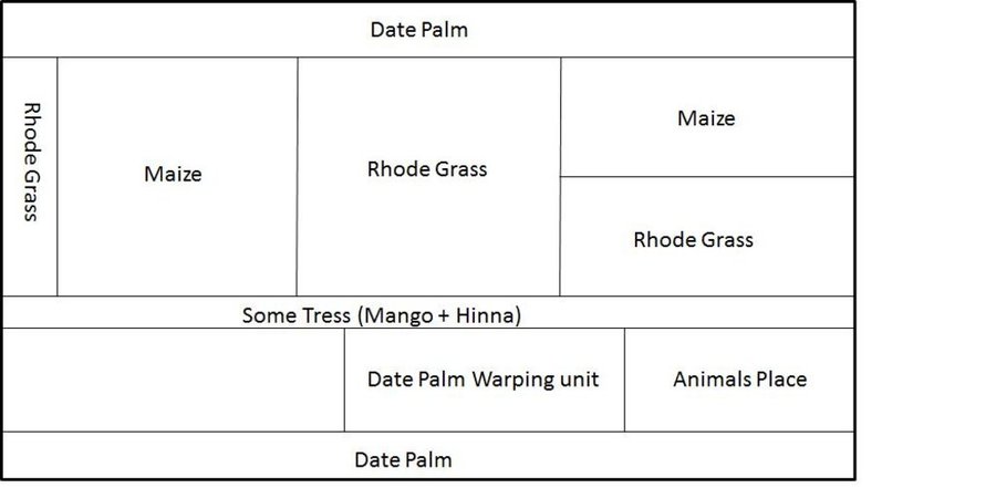
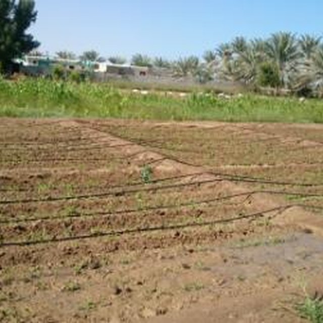
The farm total area is 7 fadan. The farm was established 40 years ago. Two labors are working in the farm. The income is low just covering the farm inputs.
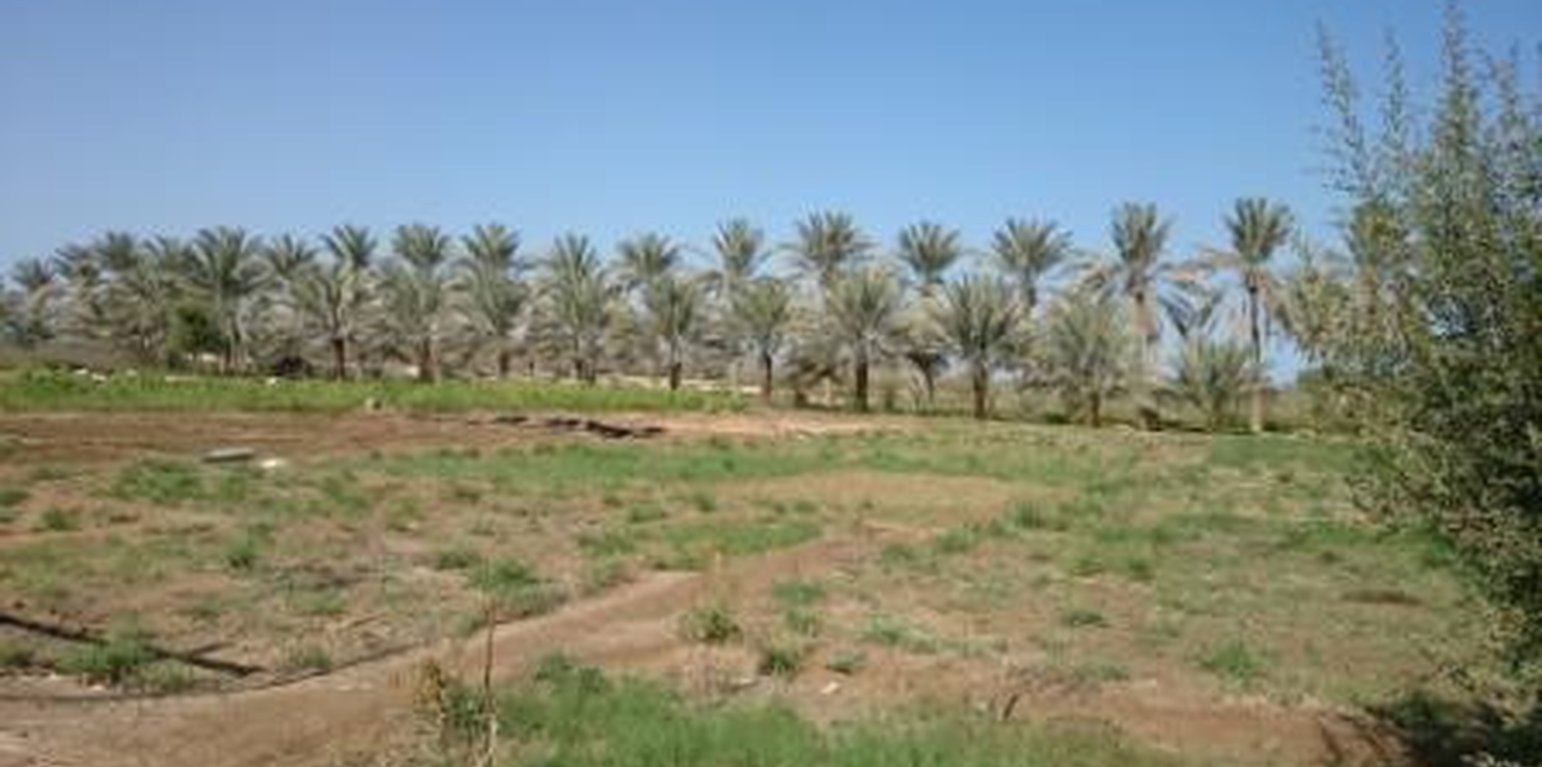
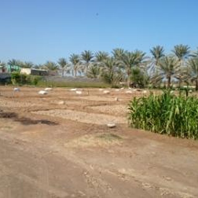
Crops planted are alfalfa, Rhodes grass, corn, Mango, Pomegranate, Date Palm, Henna tree, Buckthorn tree
Purpose of the Technology: Using saline ground water through flood irrigation for leaching salt accumulation and soil sustainability.
Establishment / maintenance activities and inputs: Main inputs are labors, tractor, date palm processing unit and machinery. the maintenance is doing for pipes and machinery.
Natural / human environment: Well water having salinity of 7.13 ds/m is used to irrigate the land also leach the soil. This has resulted an accumulated salt in the soil. Due to increase in soil salinity the cropping pattern has changed drastically. Some years ago the farm was cultivated with a variety of crops but now is limited to growing perennial crops that are salt tolerant. Date palm are the most salt tolerant plants followed by Rhodes and Alfalfa. Mangoes are sensitive to salts compared with other fruit trees.
Location
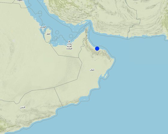
Location: Al Massena/ Al Sheeba, Al Batinah South, Oman
No. of Technology sites analysed:
Geo-reference of selected sites
Spread of the Technology: evenly spread over an area (0.0294 km²)
In a permanently protected area?:
Date of implementation:
Type of introduction
-
through land users' innovation
-
as part of a traditional system (> 50 years)
-
during experiments/ research
-
through projects/ external interventions
-
drip irrigation used for seasonal vegitables
Classification of the Technology
Main purpose
-
improve production
-
reduce, prevent, restore land degradation
-
conserve ecosystem
-
protect a watershed/ downstream areas – in combination with other Technologies
-
preserve/ improve biodiversity
-
reduce risk of disasters
-
adapt to climate change/ extremes and its impacts
-
mitigate climate change and its impacts
-
create beneficial economic impact
-
create beneficial social impact
Land use
Land use mixed within the same land unit: Yes - Agro-pastoralism (incl. integrated crop-livestock)
-
Cropland
- Annual cropping
- Tree and shrub cropping
Water supply
-
rainfed
-
mixed rainfed-irrigated
-
full irrigation
Purpose related to land degradation
-
prevent land degradation
-
reduce land degradation
-
restore/ rehabilitate severely degraded land
-
adapt to land degradation
-
not applicable
Degradation addressed
-
water degradation - Hq: decline of groundwater quality
SLM group
-
irrigation management (incl. water supply, drainage)
SLM measures
-
agronomic measures - A2: Organic matter/ soil fertility
-
vegetative measures - V1: Tree and shrub cover
-
management measures - M2: Change of management/ intensity level
Technical drawing
Technical specifications
a farm of 7 feddan mainly grown date palm, rhode grass and ,maize. the farm also a small animal yard.
Technical knowledge required for field staff / advisors: moderate
Technical knowledge required for land users: moderate
Secondary technical functions: control of raindrop splash, control of dispersed runoff: retain / trap, control of dispersed runoff: impede / retard, control of concentrated runoff: retain / trap, control of concentrated runoff: impede / retard, control of concentrated runoff: drain / divert, improvement of ground cover, improvement of surface structure (crusting, sealing), increase in organic matter
Aligned: -against wind
Vegetative material: T : trees / shrubs
In blocks
Vegetative material: G : grass
Slope (which determines the spacing indicated above): 0-2%
Change of land use practices / intensity level: land used for planting Rhodes grass and seasonal crops (recently maize was grown).
Establishment and maintenance: activities, inputs and costs
Calculation of inputs and costs
- Costs are calculated:
- Currency used for cost calculation: Omani Rial
- Exchange rate (to USD): 1 USD = 0.39 Omani Rial
- Average wage cost of hired labour per day: 10.40
Most important factors affecting the costs
labour, seeds, fertilizer and electricty
Establishment activities
-
(Timing/ frequency: all day around)
Establishment inputs and costs
| Specify input |
Unit |
Quantity |
Costs per Unit (Omani Rial) |
Total costs per input (Omani Rial) |
% of costs borne by land users |
|
Labour
|
| Labour |
ha |
1.0 |
120.0 |
120.0 |
|
| Total costs for establishment of the Technology |
120.0 |
|
| Total costs for establishment of the Technology in USD |
307.69 |
|
Maintenance activities
n.a.
Maintenance inputs and costs
| Specify input |
Unit |
Quantity |
Costs per Unit (Omani Rial) |
Total costs per input (Omani Rial) |
% of costs borne by land users |
|
Labour
|
| Labour |
ha |
1.0 |
120.0 |
120.0 |
|
| Total costs for maintenance of the Technology |
120.0 |
|
| Total costs for maintenance of the Technology in USD |
307.69 |
|
Natural environment
Average annual rainfall
-
< 250 mm
-
251-500 mm
-
501-750 mm
-
751-1,000 mm
-
1,001-1,500 mm
-
1,501-2,000 mm
-
2,001-3,000 mm
-
3,001-4,000 mm
-
> 4,000 mm
Agro-climatic zone
-
humid
-
sub-humid
-
semi-arid
-
arid
Specifications on climate
Thermal climate class: subtropics
Slope
-
flat (0-2%)
-
gentle (3-5%)
-
moderate (6-10%)
-
rolling (11-15%)
-
hilly (16-30%)
-
steep (31-60%)
-
very steep (>60%)
Landforms
-
plateau/plains
-
ridges
-
mountain slopes
-
hill slopes
-
footslopes
-
valley floors
Altitude
-
0-100 m a.s.l.
-
101-500 m a.s.l.
-
501-1,000 m a.s.l.
-
1,001-1,500 m a.s.l.
-
1,501-2,000 m a.s.l.
-
2,001-2,500 m a.s.l.
-
2,501-3,000 m a.s.l.
-
3,001-4,000 m a.s.l.
-
> 4,000 m a.s.l.
Technology is applied in
-
convex situations
-
concave situations
-
not relevant
Soil depth
-
very shallow (0-20 cm)
-
shallow (21-50 cm)
-
moderately deep (51-80 cm)
-
deep (81-120 cm)
-
very deep (> 120 cm)
Soil texture (topsoil)
-
coarse/ light (sandy)
-
medium (loamy, silty)
-
fine/ heavy (clay)
Soil texture (> 20 cm below surface)
-
coarse/ light (sandy)
-
medium (loamy, silty)
-
fine/ heavy (clay)
Topsoil organic matter content
-
high (>3%)
-
medium (1-3%)
-
low (<1%)
Groundwater table
-
on surface
-
< 5 m
-
5-50 m
-
> 50 m
Availability of surface water
-
excess
-
good
-
medium
-
poor/ none
Water quality (untreated)
-
good drinking water
-
poor drinking water (treatment required)
-
for agricultural use only (irrigation)
-
unusable
Water quality refers to:
Is salinity a problem?
Occurrence of flooding
Characteristics of land users applying the Technology
Market orientation
-
subsistence (self-supply)
-
mixed (subsistence/ commercial)
-
commercial/ market
Off-farm income
-
less than 10% of all income
-
10-50% of all income
-
> 50% of all income
Relative level of wealth
-
very poor
-
poor
-
average
-
rich
-
very rich
Level of mechanization
-
manual work
-
animal traction
-
mechanized/ motorized
Sedentary or nomadic
-
Sedentary
-
Semi-nomadic
-
Nomadic
Individuals or groups
-
individual/ household
-
groups/ community
-
cooperative
-
employee (company, government)
Age
-
children
-
youth
-
middle-aged
-
elderly
Area used per household
-
< 0.5 ha
-
0.5-1 ha
-
1-2 ha
-
2-5 ha
-
5-15 ha
-
15-50 ha
-
50-100 ha
-
100-500 ha
-
500-1,000 ha
-
1,000-10,000 ha
-
> 10,000 ha
Scale
-
small-scale
-
medium-scale
-
large-scale
Land ownership
-
state
-
company
-
communal/ village
-
group
-
individual, not titled
-
individual, titled
Land use rights
-
open access (unorganized)
-
communal (organized)
-
leased
-
individual
Water use rights
-
open access (unorganized)
-
communal (organized)
-
leased
-
individual
Access to services and infrastructure
Impacts
Socio-economic impacts
risk of production failure
production area (new land under cultivation/ use)
irrigation water availability
demand for irrigation water
expenses on agricultural inputs
diversity of income sources
Socio-cultural impacts
food security/ self-sufficiency
recreational opportunities
SLM/ land degradation knowledge
livelihood and human well-being
The technology has improve livelihoods and human well-being of the owner and his family, increasing income of the farmer changed his family lifestyle and a farm become a place for family gathering.
Ecological impacts
groundwater table/ aquifer
nutrient cycling/ recharge
soil organic matter/ below ground C
emission of carbon and greenhouse gases
Cost-benefit analysis
Benefits compared with establishment costs
Short-term returns
very negative
very positive
Long-term returns
very negative
very positive
Benefits compared with maintenance costs
Short-term returns
very negative
very positive
Long-term returns
very negative
very positive
Climate change
Gradual climate change
annual temperature increase
not well at all
very well
Climate-related extremes (disasters)
not well at all
very well
not well at all
very well
Adoption and adaptation
Percentage of land users in the area who have adopted the Technology
-
single cases/ experimental
-
1-10%
-
11-50%
-
> 50%
Of all those who have adopted the Technology, how many have done so without receiving material incentives?
-
0-10%
-
11-50%
-
51-90%
-
91-100%
Number of households and/ or area covered
75 percent of stated area
Has the Technology been modified recently to adapt to changing conditions?
To which changing conditions?
-
climatic change/ extremes
-
changing markets
-
labour availability (e.g. due to migration)
Conclusions and lessons learnt
Strengths: land user's view
Strengths: compiler’s or other key resource person’s view
-
easily implemented
-
costly effective and every farmer can implement it
-
resist to hard weather condition
Weaknesses/ disadvantages/ risks: land user's viewhow to overcome
Weaknesses/ disadvantages/ risks: compiler’s or other key resource person’s viewhow to overcome
-
in long term, ground water will be more deep
reduce over pumping
-
ground water salinity will increase
reduce over pumping
-
salt accumulation in the soil will increase
by using different soil conditioner, gypsum and soil mulch and organic manure
-
soil degradation will be the final result
References
Reviewer
-
David Streiff
-
Alexandra Gavilano
Date of documentation: June 6, 2016
Last update: June 12, 2019
Resource persons
-
Hamood Al-Hashmi - SLM specialist
-
jamaan rabeea - SLM specialist
-
Nasser Al-Wahaibi - SLM specialist
-
Badria Alhosni - SLM specialist
-
Fatma Alkharusi - SLM specialist
-
Rahma Al Habsi - SLM specialist
-
Fatima AL Abri - SLM specialist
Full description in the WOCAT database
Documentation was faciliated by
Institution
- Sultan Qaboos University (SQU) - Oman
- Test institution (TI) - Albania
Project
Key references
-
Oman Salinity Strategy, Ministry of Agriculture and Fisheries, 2012:
-
South Batinah Integrated Study, Ministry of Agriculture and Fisheries, 1993:
-
Oman General Soil Map, Ministry of Agriculture and Fisheries. 1993: