A water pond protected by a fence (Ngenzi Guy (RAB/South))

Lining geomembrane plastics for water harvesting and storage (Rwanda)

Ibidamu

Description

Lining geomembrane plastic for water harvesting and storage is a rainwater harvesting technique used by land users to collect rain water or runoff from a concave watershed to a common well-structured plastic-lined pond for agricultural, domestic and other use.

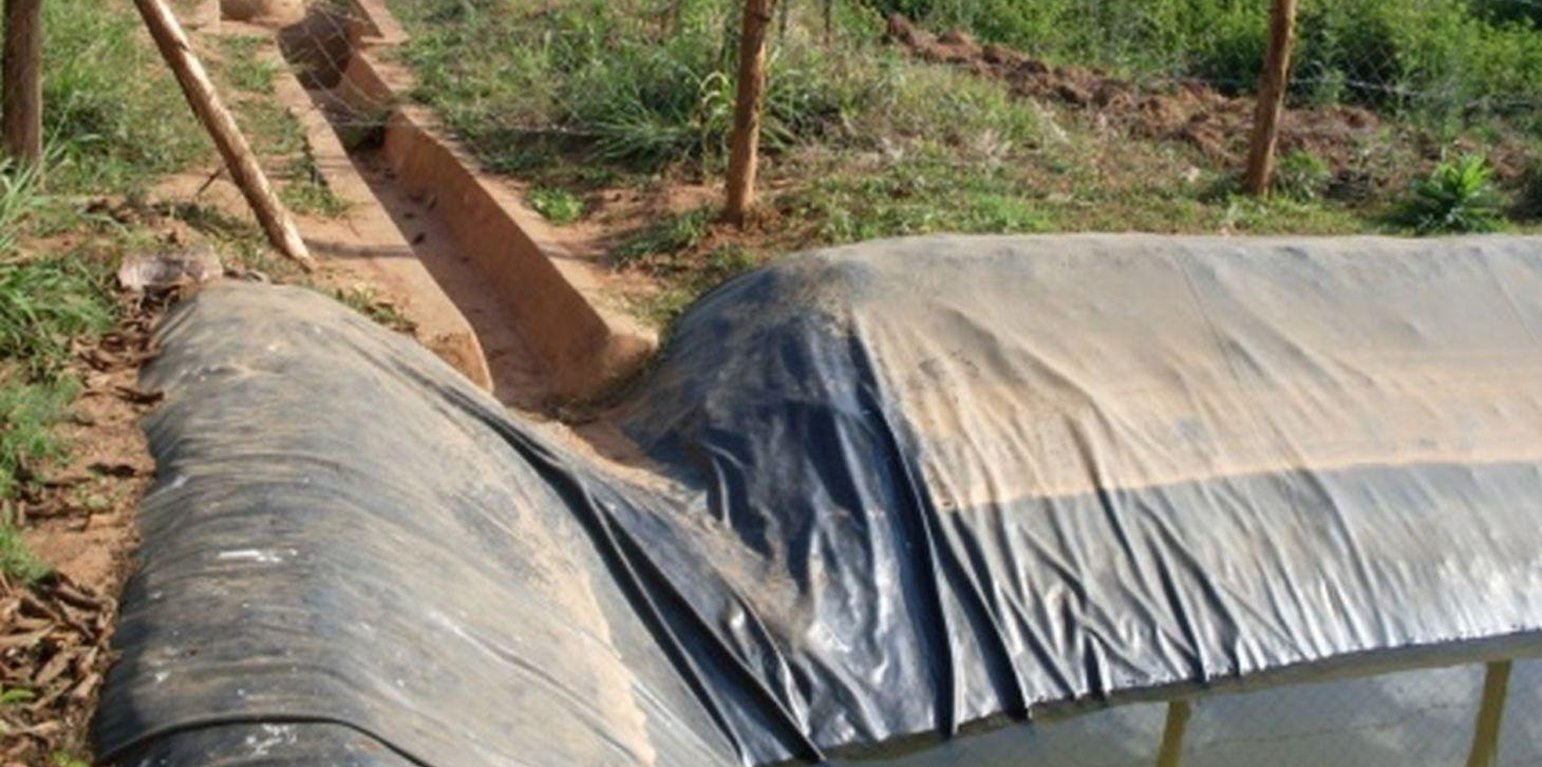
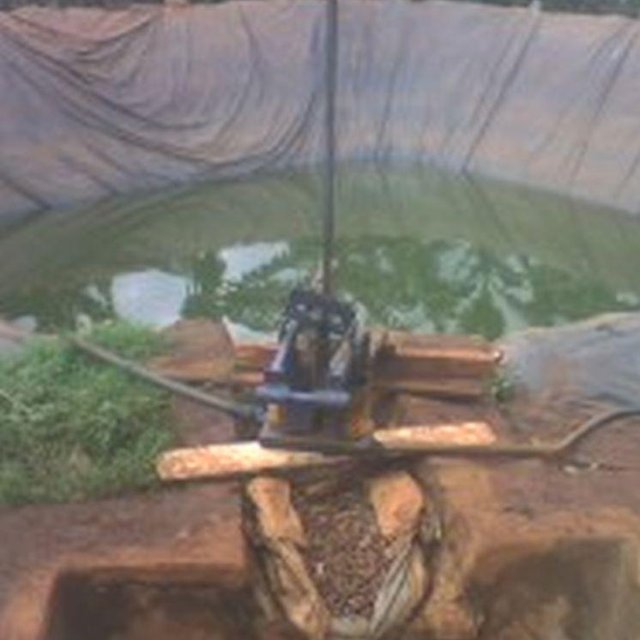
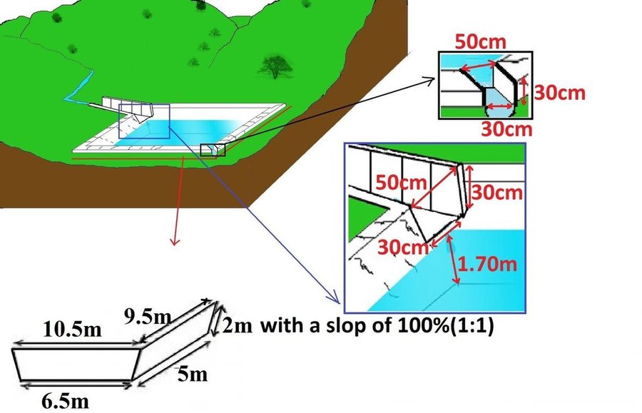
Rainwater harvesting initiatives were introduced in Rwanda in 2007, through a government-supported project on a pilot basis in three districts (Ruhango, Bugesera and Kirehe). By 2011, the technology had expanded at exponential rates such that the demand has exceeded the supply. Now the supply policy has shifted from government to private still there is a shortage of plastic lining. The typical design of each pond is trapezoidal in shape, measuring 10.5 by 9 meters top-width, 6.5 by 5 meters bottom width and 2 meters depth and a total storage volume about 120 m3. The plastic lining is factory–manufactured with standard shape and size to fit these dimensions. The ponds are made with this standard design to enable bulk purchase and supply of geo-membranes, to make use of economies of scale. The cost of the geo-membranes was subsidized by up to 100% by the government until 2010 but now only 20% are provided by the government. When this project was initiated, activities related to soil excavation was done by the government. However, with time the government pulled out and farmers are now covering the total cost of excavation and the government intervenes only for the technical compliance. The government provides technicians to train farmers on the safety and management of ponds. The volume of water harvested and stored in the ponds is on average 90 m3. However, water retention within the ponds over time differs with from farm to farm as affected by usage, evaporation and seepage losses. Treadle pumps are sometimes used to lift water by some of the farmers. Among most households, the water from the pond is used for domestic, livestock and supplemental irrigation, especially of horticultural crops. About 20% of the water is used for seedling and fruit production, 75% for livestock watering and 5% for domestic use. When the excavation of the pond is complete, the beds as well as sides of the pond have to be leveled and prepared for laying the lining plastic. Any rocks, large stones or other projections, which might damage the lining plastic, should be removed from the beds and sides of the excavated ponds.

Purpose of the Technology: Lining geomembrane plastic for water storage is designed to reduce seepage losses in ponds. This water is used by smallholder farmers to cope with the beginning of dry season and enhance crops to reach the maturity stage safely.

Establishment / maintenance activities and inputs: A periodical inspection is required for better life of the pond, thus timely maintenance hold the key of success for longer time. The maintenance includes inspection, repairing damages. Regular investigations are required on the pond sides, bottom, the inlet and the emergency outlet. In addition, the pond should be protected from intrusion of animals by constructing a fence around the pond. It is also important to remove aquatic vegetation, silt and sediment periodically that accumulate on the bottom of the pond.

Location

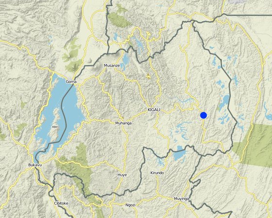
Location: Kayonza District (East provice), Rwanda, Rwanda

No. of Technology sites analysed:

Geo-reference of selected sites
  • 30.56245, -2.00774

Spread of the Technology: evenly spread over an area (approx. < 0.1 km2 (10 ha))

In a permanently protected area?:

Date of implementation: less than 10 years ago (recently)

Type of introduction
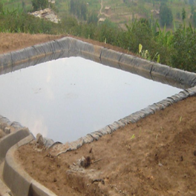
A lining geomembrane plastic is used to stop infiltration of the stored water into the soil (Kagabo Desire and Ngenzi Guy (Kabarondo))
Water pond coupled with a foot pump (Kagabo Desire and Ngenzi Guy (RAB))

Classification of the Technology

Main purpose
  • improve production
  • reduce, prevent, restore land degradation
  • conserve ecosystem
  • protect a watershed/ downstream areas – in combination with other Technologies
  • preserve/ improve biodiversity
  • reduce risk of disasters
  • adapt to climate change/ extremes and its impacts
  • mitigate climate change and its impacts
  • create beneficial economic impact
  • create beneficial social impact
  • access to water
Land use

  • Cropland
    • Annual cropping: cereals - maize, legumes and pulses - beans, vegetables - other
Water supply
  • rainfed
  • mixed rainfed-irrigated
  • full irrigation

Purpose related to land degradation
  • prevent land degradation
  • reduce land degradation
  • restore/ rehabilitate severely degraded land
  • adapt to land degradation
  • not applicable
Degradation addressed
  • soil erosion by water - Wg: gully erosion/ gullying, Wo: offsite degradation effects
  • water degradation - Ha: aridification
SLM group
  • water harvesting
SLM measures
  • structural measures - S5: Dams, pans, ponds

Technical drawing

Technical specifications
Surface runoff water storage pond have got a reservoir of 10.5m x 9.5m at top and 6.5m x 5m at bottom and a depth of 2m with side slope of 1:1.5. The capacity of one pond is estimated about 120m3.

Location: Kabarondo. Kayonza/West/Rwanda

Date: 2013

Technical knowledge required for field staff / advisors: high (The technology need skilled engineers)

Technical knowledge required for land users: moderate (It need moderately skilled labor to construct the technology under supervision of engineers.)

Main technical functions: control of concentrated runoff: retain / trap, water harvesting / increase water supply

Secondary technical functions: water spreading

Dam/ pan/ pond
Vertical interval between structures (m): 2
Spacing between structures (m): 20
Depth of ditches/pits/dams (m): 2
Width of ditches/pits/dams (m): 9.5
Length of ditches/pits/dams (m): 10.5

Construction material (earth): the original land is digging

Construction material (stone): stones are used to concrete the pond inlet and outlet

Construction material (concrete): Cements, sand

Construction material (other): fencing wire and waterproof steering(plastic sheet)

Lateral gradient along the structure: 0%

Specification of dams/ pans/ ponds: Capacity 120m3

Catchment area: 6ham2

Beneficial area: valleym2

Slope of dam wall inside: 50%;
Slope of dam wall outside: 50%

Dimensions of spillways: 0.8m x0.6mm

For water harvesting: the ratio between the area where the harvested water is applied and the total area from which water is collected is: 1:0.25
Author: Kagabo Desire and Ngenzi Guy, RAB, 5016 Kigali

Establishment and maintenance: activities, inputs and costs

Calculation of inputs and costs
  • Costs are calculated:
  • Currency used for cost calculation: Rwandan francs
  • Exchange rate (to USD): 1 USD = 640.0 Rwandan francs
  • Average wage cost of hired labour per day: 1000
Most important factors affecting the costs
The most factors that affects the cost is the construction materials and labor.
Establishment activities
  1. Surveying (Timing/ frequency: any time)
  2. Buying materials (Timing/ frequency: Any time after surveying)
  3. Construction of pond (Timing/ frequency: Dry season)
Establishment inputs and costs
Specify input Unit Quantity Costs per Unit (Rwandan francs) Total costs per input (Rwandan francs) % of costs borne by land users
Labour
Surveying persons/day/ha 4.0 45000.0 180000.0
Construction of pond persons/day/ha 180.0 1000.0 180000.0 80.0
Equipment
Tools pieces/ha 100.0 3000.0 300000.0 20.0
Construction material
Cements kg 300.0 200.0 60000.0
Plastic sheet m2 24.0 2500.0 60000.0
Stone m3 8.0 562.5 4500.0
Sand m3 8.0 390.625 3125.0
Fencing wire m2 24.0 625.0 15000.0
Total costs for establishment of the Technology 802'625.0
Total costs for establishment of the Technology in USD 1'254.1
Maintenance activities
  1. regular maintenance of Channels and all around the pond. (Timing/ frequency: Rainy season)
Maintenance inputs and costs
Specify input Unit Quantity Costs per Unit (Rwandan francs) Total costs per input (Rwandan francs) % of costs borne by land users
Labour
Regular maintenance persons/day/ha 10.0 1000.0 10000.0 100.0
Total costs for maintenance of the Technology 10'000.0
Total costs for maintenance of the Technology in USD 15.63

Natural environment

Average annual rainfall
  • < 250 mm
  • 251-500 mm
  • 501-750 mm
  • 751-1,000 mm
  • 1,001-1,500 mm
  • 1,501-2,000 mm
  • 2,001-3,000 mm
  • 3,001-4,000 mm
  • > 4,000 mm
Agro-climatic zone
  • humid
  • sub-humid
  • semi-arid
  • arid
Specifications on climate
Thermal climate class: tropics
Slope
  • flat (0-2%)
  • gentle (3-5%)
  • moderate (6-10%)
  • rolling (11-15%)
  • hilly (16-30%)
  • steep (31-60%)
  • very steep (>60%)
Landforms
  • plateau/plains
  • ridges
  • mountain slopes
  • hill slopes
  • footslopes
  • valley floors
Altitude
  • 0-100 m a.s.l.
  • 101-500 m a.s.l.
  • 501-1,000 m a.s.l.
  • 1,001-1,500 m a.s.l.
  • 1,501-2,000 m a.s.l.
  • 2,001-2,500 m a.s.l.
  • 2,501-3,000 m a.s.l.
  • 3,001-4,000 m a.s.l.
  • > 4,000 m a.s.l.
Technology is applied in
  • convex situations
  • concave situations
  • not relevant
Soil depth
  • very shallow (0-20 cm)
  • shallow (21-50 cm)
  • moderately deep (51-80 cm)
  • deep (81-120 cm)
  • very deep (> 120 cm)
Soil texture (topsoil)
  • coarse/ light (sandy)
  • medium (loamy, silty)
  • fine/ heavy (clay)
Soil texture (> 20 cm below surface)
  • coarse/ light (sandy)
  • medium (loamy, silty)
  • fine/ heavy (clay)
Topsoil organic matter content
  • high (>3%)
  • medium (1-3%)
  • low (<1%)
Groundwater table
  • on surface
  • < 5 m
  • 5-50 m
  • > 50 m
Availability of surface water
  • excess
  • good
  • medium
  • poor/ none
Water quality (untreated)
  • good drinking water
  • poor drinking water (treatment required)
  • for agricultural use only (irrigation)
  • unusable
Water quality refers to:
Is salinity a problem?
  • Yes
  • No

Occurrence of flooding
  • Yes
  • No
Species diversity
  • high
  • medium
  • low
Habitat diversity
  • high
  • medium
  • low

Characteristics of land users applying the Technology

Market orientation
  • subsistence (self-supply)
  • mixed (subsistence/ commercial)
  • commercial/ market
Off-farm income
  • less than 10% of all income
  • 10-50% of all income
  • > 50% of all income
Relative level of wealth
  • very poor
  • poor
  • average
  • rich
  • very rich
Level of mechanization
  • manual work
  • animal traction
  • mechanized/ motorized
Sedentary or nomadic
  • Sedentary
  • Semi-nomadic
  • Nomadic
Individuals or groups
  • individual/ household
  • groups/ community
  • cooperative
  • employee (company, government)
Gender
  • women
  • men
Age
  • children
  • youth
  • middle-aged
  • elderly
Area used per household
  • < 0.5 ha
  • 0.5-1 ha
  • 1-2 ha
  • 2-5 ha
  • 5-15 ha
  • 15-50 ha
  • 50-100 ha
  • 100-500 ha
  • 500-1,000 ha
  • 1,000-10,000 ha
  • > 10,000 ha
Scale
  • small-scale
  • medium-scale
  • large-scale
Land ownership
  • state
  • company
  • communal/ village
  • group
  • individual, not titled
  • individual, titled
Land use rights
  • open access (unorganized)
  • communal (organized)
  • leased
  • individual
Water use rights
  • open access (unorganized)
  • communal (organized)
  • leased
  • individual
Access to services and infrastructure
health

poor
x
good
education

poor
x
good
technical assistance

poor
x
good
employment (e.g. off-farm)

poor
x
good
markets

poor
x
good
energy

poor
x
good
roads and transport

poor
x
good
drinking water and sanitation

poor
x
good
financial services

poor
x
good

Impacts

Socio-economic impacts
Crop production
decreased
x
increased

Quantity before SLM: 200 kg
Quantity after SLM: 800 kg

risk of production failure
increased
x
decreased

Quantity before SLM: 50%
Quantity after SLM: 10%

farm income
decreased
x
increased

Quantity before SLM: 40%
Quantity after SLM: 80%
40% of income increases due to increase of agriculture

Socio-cultural impacts
food security/ self-sufficiency
reduced
x
improved

health situation
worsened
x
improved


The technology improved the productivity so that farmers had means to take health insurance

SLM/ land degradation knowledge
reduced
x
improved


Increases up to 15%

livelihood and human well-being
reduced
x
improved


It has increased income of household hence enhance life.

Ecological impacts
harvesting/ collection of water (runoff, dew, snow, etc)
reduced
x
improved


60% improved

soil loss
increased
x
decreased

pest/ disease control
decreased
x
increased

Quantity before SLM: 20%
Quantity after SLM: 50%
It increases the predominance of mosquito

Off-site impacts
downstream siltation
increased
x
decreased

Cost-benefit analysis

Benefits compared with establishment costs
Short-term returns
very negative
x
very positive

Long-term returns
very negative
x
very positive

Benefits compared with maintenance costs
Short-term returns
very negative
x
very positive

Long-term returns
very negative
x
very positive

It require light labor during the maintenance activities

Climate change

Gradual climate change
annual temperature increase

not well at all
x
very well
Climate-related extremes (disasters)
local rainstorm

not well at all
x
very well
local windstorm

not well at all
very well
Answer: not known
drought

not well at all
x
very well
general (river) flood

not well at all
x
very well

Adoption and adaptation

Percentage of land users in the area who have adopted the Technology
  • single cases/ experimental
  • 1-10%
  • 11-50%
  • > 50%
Of all those who have adopted the Technology, how many have done so without receiving material incentives?
  • 0-10%
  • 11-50%
  • 51-90%
  • 91-100%
Number of households and/ or area covered
260 household covering 90 percent of stated area
Has the Technology been modified recently to adapt to changing conditions?
  • Yes
  • No
To which changing conditions?
  • climatic change/ extremes
  • changing markets
  • labour availability (e.g. due to migration)

Conclusions and lessons learnt

Strengths: land user's view
Strengths: compiler’s or other key resource person’s view
  • Income generation

    How can they be sustained / enhanced? More financial support and trainings
  • Improvement of production

    How can they be sustained / enhanced? To make a regular maintenance of ponds
  • Soil erosion control

    How can they be sustained / enhanced? Divert more runoff to mitigate the soil erosion downstream and always clean the conveying channel.
  • Impermeable material

    How can they be sustained / enhanced? Acquisition of high quality plastics that can last many years
Weaknesses/ disadvantages/ risks: land user's viewhow to overcome
Weaknesses/ disadvantages/ risks: compiler’s or other key resource person’s viewhow to overcome
  • Occasional accidents To maintain fences around the pond and increase awareness about accidents around a pond, especially for parents (high risk for small kids)
  • Pond attract various insects and diseases (habitat for Mosquitoes) Mosquito nets are needed

References

Compiler
  • Iwona Piechowiak
Editors
Reviewer
  • David Streiff
  • Alexandra Gavilano
Date of documentation: Dec. 25, 2012
Last update: June 17, 2019
Resource persons
Full description in the WOCAT database
Linked SLM data
Documentation was faciliated by
Institution Project
Key references
  • Kagera TAMP project website: http://www.fao.org/nr/kagera/en/
This work is licensed under Creative Commons Attribution-NonCommercial-ShareaAlike 4.0 International