Rip-ploughing, oversowing
(South Africa)
Insaai (Afrikaans)
Description
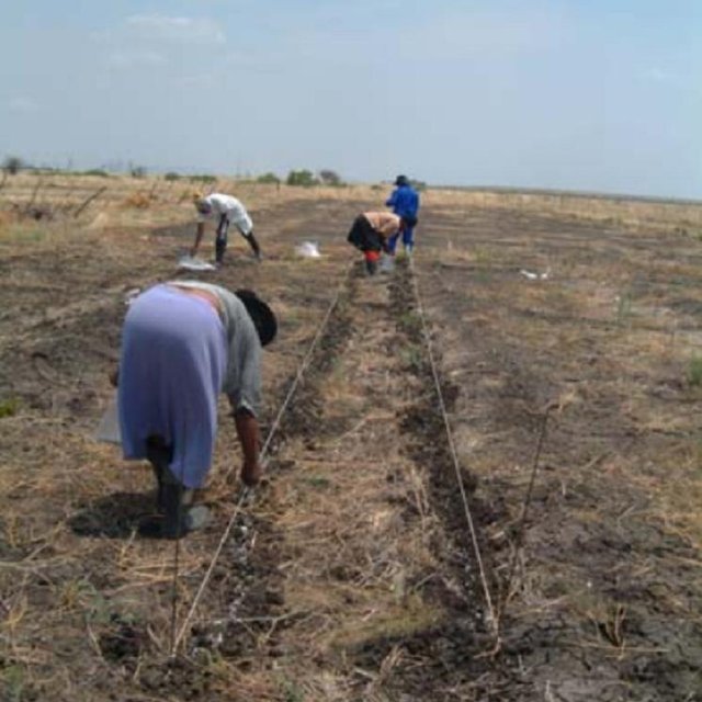
Ripploughing and oversowing (sodsowing) of extensive grazing land in order to improve productivity of a semi-arid rangeland.
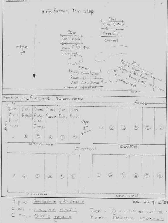
A pasture characterised by the unpalatable Cymbopogen plurinoides grass species was rip-ploughed to a depth of 20, 15, or 7 cm to uproot the unfavourable grass species.
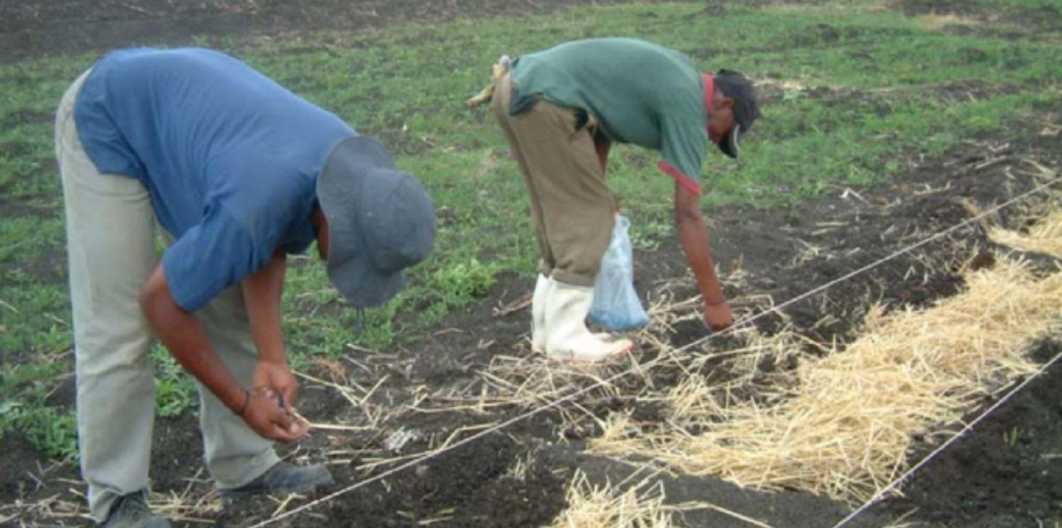
Coated and uncoated seeds of more palatable grass species were hand sown into the furrows and the soil kicked over the seeds.
Grazing has been excluded for the past four years, giving the sown-in grass species the opportunity to establish and credit the soil seed bank.
The purpose of the technology was threefold: First, the success of rip-ploughing as a restoration technology was researched. Secondly, the suitability of coated or uncoated seeds was established. Thirdly, the suitability of the technology for restoration purposes was researched. This was done in the summer of 1995/96. The frequency and density was measured in the following years up to 1999. The density was measured with a 1 x 1 square meter; and tillers, vegetative and reproductive plants were distinguished.
The purpose of the frequency measurement is to establish the percentage a grass species contributes to the grass community. The density measurement gives the amount of rooted plants in a square meter. Distinction between the life stages indicates the self-sustainability of a population. Seed bank analyses are also added.
Location
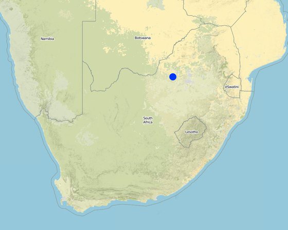
Location: Madikwe, Koster, Potchefstroom, North West Province, South Africa
No. of Technology sites analysed:
Geo-reference of selected sites
Spread of the Technology: evenly spread over an area (0.1 km²)
In a permanently protected area?:
Date of implementation: less than 10 years ago (recently)
Type of introduction
-
through land users' innovation
-
as part of a traditional system (> 50 years)
-
during experiments/ research
-
through projects/ external interventions
Coated and uncoated seeds were hand sown into furrows
Classification of the Technology
Main purpose
-
improve production
-
reduce, prevent, restore land degradation
-
conserve ecosystem
-
protect a watershed/ downstream areas – in combination with other Technologies
-
preserve/ improve biodiversity
-
reduce risk of disasters
-
adapt to climate change/ extremes and its impacts
-
mitigate climate change and its impacts
-
create beneficial economic impact
-
create beneficial social impact
Land use
-
Grazing land
- Semi-nomadic pastoralism
- Ranching
Water supply
-
rainfed
-
mixed rainfed-irrigated
-
full irrigation
Purpose related to land degradation
-
prevent land degradation
-
reduce land degradation
-
restore/ rehabilitate severely degraded land
-
adapt to land degradation
-
not applicable
Degradation addressed
-
soil erosion by water - Wt: loss of topsoil/ surface erosion
-
chemical soil deterioration - Cn: fertility decline and reduced organic matter content (not caused by erosion)
-
water degradation - Ha: aridification
SLM group
-
improved plant varieties/ animal breeds
Technical drawing
Technical specifications
Site plan for rip-ploughing and hand sowing of palatable grasses.
North West
Date: 1999
Technical knowledge required for field staff / advisors: low
Technical knowledge required for land users: moderate
Main technical functions: control of concentrated runoff: drain / divert, improvement of ground cover, increase of surface roughness, improvement of topsoil structure (compaction), increase in organic matter, increase of infiltration, increase / maintain water stored in soil
Secondary technical functions: control of raindrop splash, control of dispersed runoff: retain / trap, control of dispersed runoff: impede / retard, control of concentrated runoff: retain / trap, control of concentrated runoff: impede / retard, reduction of slope angle, reduction of slope length, water harvesting / increase water supply, water spreading, sediment retention / trapping, sediment harvesting, reduction in wind speed, increase in soil fertility
Scattered / dispersed
Vegetative material: G : grass
Number of plants per (ha): 100
Spacing between rows / strips / blocks (m): 0.8
Grass species: Anthephora pubescens, Digitaria erlantha, Chloris gayana, Cenchrus ciliaris, Panicum maximum
Slope (which determines the spacing indicated above): 8.00%
If the original slope has changed as a result of the Technology, the slope today is (see figure below): 8.00%
Change of land use type: Area close for plant establishment
Change of land use practices / intensity level: After plant establishment grazing occurs as in 2.4.3.3
Author: Sarone de Wet
Establishment and maintenance: activities, inputs and costs
Calculation of inputs and costs
- Costs are calculated: per Technology area (size and area unit: ha)
- Currency used for cost calculation: USD
- Exchange rate (to USD): 1 USD = n.a
- Average wage cost of hired labour per day: 8.30
Most important factors affecting the costs
Labour and transport; equipment (gasoline).
Establishment activities
-
Seedbed reparation (Timing/ frequency: Summer)
-
Sowing of seeds (Timing/ frequency: Summer)
-
Enclosing site (Timing/ frequency: Summer)
-
Debushing were necessary (Timing/ frequency: Early Summer)
-
Area enclosure (Timing/ frequency: From start for 2 years)
Establishment inputs and costs (per ha)
| Specify input |
Unit |
Quantity |
Costs per Unit (USD) |
Total costs per input (USD) |
% of costs borne by land users |
|
Labour
|
| Constructing seed beds and |
persons/day/ha |
36.0 |
8.3 |
298.8 |
|
|
Equipment
|
| Machine use |
ha |
1.0 |
10.0 |
10.0 |
|
| Total costs for establishment of the Technology |
308.8 |
|
| Total costs for establishment of the Technology in USD |
308.8 |
|
Maintenance activities
-
Grazing excluded (Timing/ frequency: /Continuously)
-
Grazing (Timing/ frequency: Spring (Apr-Sept) /After 2 y for a week; then after regrowth)
-
Rotation grazing (Timing/ frequency: Late summer after 2nd year / Once a year for winte)
Natural environment
Average annual rainfall
-
< 250 mm
-
251-500 mm
-
501-750 mm
-
751-1,000 mm
-
1,001-1,500 mm
-
1,501-2,000 mm
-
2,001-3,000 mm
-
3,001-4,000 mm
-
> 4,000 mm
Agro-climatic zone
-
humid
-
sub-humid
-
semi-arid
-
arid
Specifications on climate
430mm and 520 mm
Slope
-
flat (0-2%)
-
gentle (3-5%)
-
moderate (6-10%)
-
rolling (11-15%)
-
hilly (16-30%)
-
steep (31-60%)
-
very steep (>60%)
Landforms
-
plateau/plains
-
ridges
-
mountain slopes
-
hill slopes
-
footslopes
-
valley floors
Altitude
-
0-100 m a.s.l.
-
101-500 m a.s.l.
-
501-1,000 m a.s.l.
-
1,001-1,500 m a.s.l.
-
1,501-2,000 m a.s.l.
-
2,001-2,500 m a.s.l.
-
2,501-3,000 m a.s.l.
-
3,001-4,000 m a.s.l.
-
> 4,000 m a.s.l.
Technology is applied in
-
convex situations
-
concave situations
-
not relevant
Soil depth
-
very shallow (0-20 cm)
-
shallow (21-50 cm)
-
moderately deep (51-80 cm)
-
deep (81-120 cm)
-
very deep (> 120 cm)
Soil texture (topsoil)
-
coarse/ light (sandy)
-
medium (loamy, silty)
-
fine/ heavy (clay)
Soil texture (> 20 cm below surface)
-
coarse/ light (sandy)
-
medium (loamy, silty)
-
fine/ heavy (clay)
Topsoil organic matter content
-
high (>3%)
-
medium (1-3%)
-
low (<1%)
Groundwater table
-
on surface
-
< 5 m
-
5-50 m
-
> 50 m
Availability of surface water
-
excess
-
good
-
medium
-
poor/ none
Water quality (untreated)
-
good drinking water
-
poor drinking water (treatment required)
-
for agricultural use only (irrigation)
-
unusable
Is salinity a problem?
Occurrence of flooding
Characteristics of land users applying the Technology
Market orientation
-
subsistence (self-supply)
-
mixed (subsistence/ commercial)
-
commercial/ market
Off-farm income
-
less than 10% of all income
-
10-50% of all income
-
> 50% of all income
Relative level of wealth
-
very poor
-
poor
-
average
-
rich
-
very rich
Level of mechanization
-
manual work
-
animal traction
-
mechanized/ motorized
Sedentary or nomadic
-
Sedentary
-
Semi-nomadic
-
Nomadic
Individuals or groups
-
individual/ household
-
groups/ community
-
cooperative
-
employee (company, government)
Age
-
children
-
youth
-
middle-aged
-
elderly
Area used per household
-
< 0.5 ha
-
0.5-1 ha
-
1-2 ha
-
2-5 ha
-
5-15 ha
-
15-50 ha
-
50-100 ha
-
100-500 ha
-
500-1,000 ha
-
1,000-10,000 ha
-
> 10,000 ha
Scale
-
small-scale
-
medium-scale
-
large-scale
Land ownership
-
state
-
company
-
communal/ village
-
group
-
individual, not titled
-
individual, titled
Land use rights
-
open access (unorganized)
-
communal (organized)
-
leased
-
individual
Water use rights
-
open access (unorganized)
-
communal (organized)
-
leased
-
individual
Access to services and infrastructure
Impacts
Socio-economic impacts
farm income
Able to carry more livestock in a sustainable way
input constraints
Labourers expect more money
Socio-cultural impacts
SLM/ land degradation knowledge
Ecological impacts
soil moisture
Compared to none treated site
soil loss
Vegetation cover binds soil
palatability draw animals
If not controlled - overgrazing
Off-site impacts
downstream siltation
Vegetation bind soil; denser covering of soil
wind transported sediments
Cost-benefit analysis
Benefits compared with establishment costs
Short-term returns
very negative
very positive
Long-term returns
very negative
very positive
Benefits compared with maintenance costs
Short-term returns
very negative
very positive
Long-term returns
very negative
very positive
Adoption and adaptation
Percentage of land users in the area who have adopted the Technology
-
single cases/ experimental
-
1-10%
-
11-50%
-
> 50%
Of all those who have adopted the Technology, how many have done so without receiving material incentives?
-
0-10%
-
11-50%
-
51-90%
-
91-100%
Number of households and/ or area covered
30 households
Has the Technology been modified recently to adapt to changing conditions?
To which changing conditions?
-
climatic change/ extremes
-
changing markets
-
labour availability (e.g. due to migration)
Conclusions and lessons learnt
Strengths: land user's view
-
Vegetation cover
How can they be sustained / enhanced? Rotational grazing
Strengths: compiler’s or other key resource person’s view
-
Establishment of perennial grass cover
How can they be sustained / enhanced? Grazing management; not graze to seed production stage.
-
Increase of perennial grass production
How can they be sustained / enhanced? Grazing management
-
Find suitable seed mixtures for different habitats
How can they be sustained / enhanced? Literature study on habitat preferences
-
Seed bed preparation enhance establishment
How can they be sustained / enhanced? Know exact depth of sowing of seeds.
Weaknesses/ disadvantages/ risks: land user's viewhow to overcome
Weaknesses/ disadvantages/ risks: compiler’s or other key resource person’s viewhow to overcome
-
Implementation in communal areas mostly
Brainstorm on implementation without gasoline needed.
-
Communication with landuser
Contact on monthly basis built friendship
References
Reviewer
-
David Streiff
-
Alexandra Gavilano
Date of documentation: Jan. 15, 2011
Last update: June 20, 2019
Resource persons
-
Saroné De Wet - SLM specialist
-
Asterid Hattingh - None
Full description in the WOCAT database
Documentation was faciliated by
Key references
-
Veld management in South Africa, Tainton. 1985.: From researcher