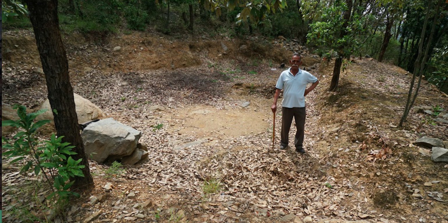
Recharge Ponds in Nakina Van Panchayat Community Forest (Hanspeter Liniger)

Recharge Ponds and Recharge Trenches (India)

Chaal or Khals (recharge pond) and Khanti (recharge trenches)

Description

Recharge ponds (Chaals or khals) and recharge trenches (khanti) are common methods to catch the surface runoff and increase the infiltration to recharge groundwater and aid in natural spring recharge in the middle mountain regions.

1. The recharge ponds and trenches have been applied in mountainous community forests. There have been about 60 trenches, 1 large and 4 small recharge ponds constructed in the specific sites in the community forest of Naikina. These are ideal areas to implement these technologies, as they encompass the microwatershed/springsheds of 3 springs.

a. Recharge ponds are circular or rectangular dugout structures which were constructed a natural depression area on sloping land. The standard size is usually as follows: Length =3 m, Width =3 m and Depth = 0.7 m, with site specific modifications. Water feeder channels which flow to the ponds helps to harvest additional surface flow. The walls are not vertical but have a 45 degree slope to prevent cave in.

b.Recharge trenches are small rectangular structures of typical dimensions: Length=1.5 m, Width= 1m , Depth= 0.7 m, constructed on sloping land in a staggered manner. The slope of the walls should be not more than 45 degrees, and the size of the trenches and their spacing depends on the slope of the land. In higher slope areas, one should construct smaller staggered trenches with closer spacing. These are generally made in high rainfall areas, as there is an increased danger of overflow. In staggered trenching, the trenches are located directly below one another in alternate rows and in a staggered fashion. These may be 2 m to 3 m long and the spacing between the rows may vary from 3 m to 5 m.

2. Aims/Objectives: The central focus of the technology is water conservation and harvesting of surplus monsoon runoff to recharge groundwater reservoirs, which is otherwise going un-utilized. Additionally, land degradation by water erosion is decreased due to slowing of runoff and increased soil infiltration. Water erosion after intense rainfall affects both onsite and offsite sites, causing soil displacement, increased frequency of landslides, damage to vegetation, agriculture land, and village settlements.

3. Methods: Due to decreased spring discharge in the dry season and high dependency on the springs for drinking water (humans and livestock), the community has implemented these technologies within in catchment areas of 3 essential springs (Bhind, Vaishnavi, and Bagawoti) in the last 3 years.

4. Stages of Implementation: Awareness building, community mobilization, and central planning was done by the head of the Forest Council (Gram Panchayat), Mr. Jagdamba Joshi. Recharge pond and trench construction was done over the course of a month by different villagers that were available to participate. They were incentivized to work with a small compensation of 5.30 USD (400 INR)/day. Activities and inputs included time and manual labor (about 3 days for the large recharge pond, 0.5-1 day for each of the small recharge ponds, and 4 days for 60 recharge trenches) and appropriate land-use planning and management. Primarily, the strategic construction of these technologies and selection in appropriate springshed recharge/catchment areas has led their success. The structures have been placed below the pine forest, (which generates high runoff) and reside in a restored broadleaf forest, which acts like a sponge to retain the runoff water flowing down from the pine forest above. The ponds lies in a natural, leveled depression with gentle slopes around. Broadleaf/oak dominated forest areas have been increasingly supported as technology construction sites, as the placement further improves of groundwater recharge.

To assure long-term effectiveness, maintenance and re-digging of the recharge ponds and trenches is carried out by villagers annually, pre-monsoon.

5. Gram Panchayat, Mr. Joshi has played a key role in informing the villagers of technology design, function and importance for supporting the community forest and subsequent spring recharge. He has previous knowledge of the application of these technologies through first-hand experiences working in the army. The villagers were solely responsible for construction with Mr. Joshi's guidance. The men were mainly responsible for making recharge ponds and the women dug trenches and removed weeds.

6) Technology benefits/impacts acknowledged by the community: moisture conservation, long-term groundwater recharge, spring recharge, reduction of soil-water erosion, improved infiltration and support for vegetation cover and broadleaf/oak forest.

Like: Relatively simple and inexpensive, little external inputs required, effective in short and long-term (provided site appropriate selection and regular seasonal rainfall)

Dislike: Drudgery, time consuming, maintenance required, distance (site of implementation may also be far from village).
Location

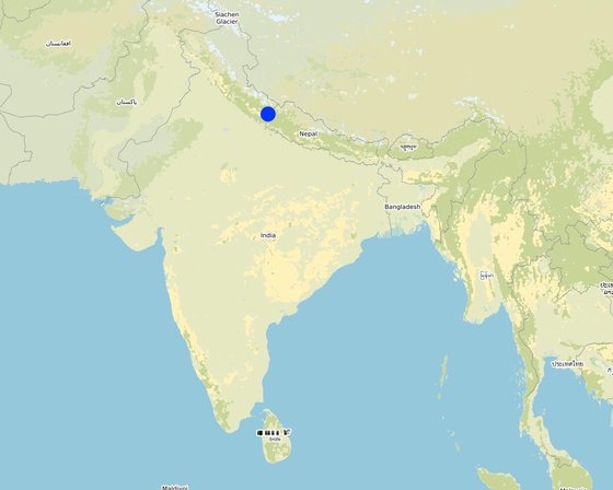
Location: Nakina Village, Pithoragarh Bloc, Uttarakhand, India

No. of Technology sites analysed: 2-10 sites

Geo-reference of selected sites
  • 80.1752, 29.62553
  • 80.17542, 29.62565
  • 80.17244, 29.62732
  • 80.17369, 29.627
  • 80.17399, 29.62706

Spread of the Technology: applied at specific points/ concentrated on a small area

In a permanently protected area?: Yes

Date of implementation: 2016

Type of introduction
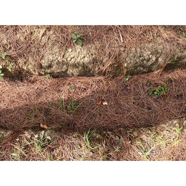
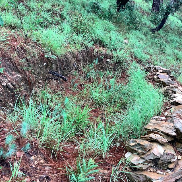
Recharge Trench (Jaclyn Bandy)
Small Recharge Pond in the Nakina Forest (Jaclyn Bandy)

Classification of the Technology

Main purpose
  • improve production
  • reduce, prevent, restore land degradation
  • conserve ecosystem
  • protect a watershed/ downstream areas – in combination with other Technologies
  • preserve/ improve biodiversity
  • reduce risk of disasters
  • adapt to climate change/ extremes and its impacts
  • mitigate climate change and its impacts
  • create beneficial economic impact
  • create beneficial social impact
Land use
Land use mixed within the same land unit: Yes

  • Forest/ woodlands
    • (Semi-)natural forests/ woodlands: subtropical mountain systems natural vegetation, Broadleaf/pine mixed forest. Management: Selective felling
    • Tree plantation, afforestation: subtropical dry forest plantation - Broadleaf. Varieties: Mixed varieties
    Tree types (deciduous): n.a.
    Products and services: Timber, Fuelwood, Nature conservation/ protection

Water supply
  • rainfed
  • mixed rainfed-irrigated
  • full irrigation

Purpose related to land degradation
  • prevent land degradation
  • reduce land degradation
  • restore/ rehabilitate severely degraded land
  • adapt to land degradation
  • not applicable
Degradation addressed
  • soil erosion by water - Wt: loss of topsoil/ surface erosion, Wg: gully erosion/ gullying, Wm: mass movements/ landslides, Wo: offsite degradation effects
  • water degradation - Hs: change in quantity of surface water, Hg: change in groundwater/aquifer level
SLM group
  • water harvesting
SLM measures
  • structural measures - S4: Level ditches, pits, S5: Dams, pans, ponds

Technical drawing

Technical specifications
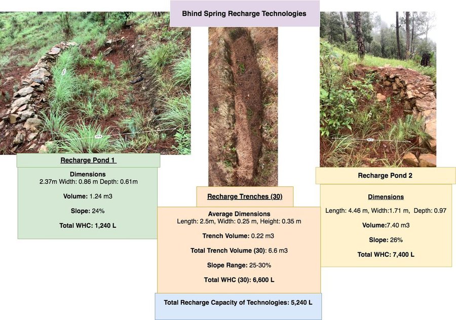
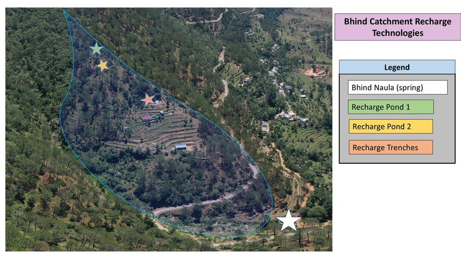
Bhind Catchment (Springshed) Recharge Technologies
Dimensions
Recharge Pond 1- Length: 2.37m Width: 0.86 m Depth: 0.61m
Pond 1 Volume- 1.24 m3
Slope: 24%

Recharge Pond 2- Length: 4.46 m, Width: 1.71 m, Depth: 0.97
Pond 2 Volume- 7.40 m3
Slope: 26%

Recharge Trench- Length: 2.5m, Width: 0.25 m, Height: 0.35 m
Trench Volume: 0.22 m3
Total Trench Volume (30): 6.6 m3

Spacing: Trenches are in different locations of the Bhind springshed, 20 functional trenches are aggregated within 1m of each other in a broadleaf forest just north on the cucumber farm. 10 trenches are located directly above the Cucumber farm.
Slope Range: 25-30%

Water Holding Capacity (L):
Total Capacity of Recharge Pond 1: 1,240 L
Total Capacity of Recharge Pond 2: 7,400 L
Total Capacity of Trenches (30): 6,600 L

Total WHC of Technologies: 15,240 L

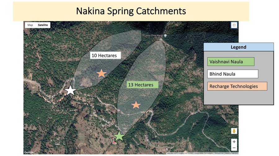
Total Catchment area of Bhind Springshed: ~10 Hectares
Author: Jaclyn Bandy
Bhind Catchment Recharge Technologies: Location Map
Author: Jaclyn Bandy
Nakina Spring Catchments (springsheds) and Technology Locations
Author: Jaclyn Bandy
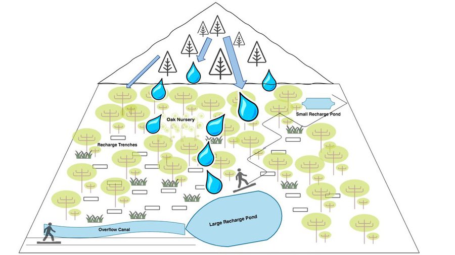
Vaishnavi Recharge Structures Diagram Map
Author: Jaclyn Bandy
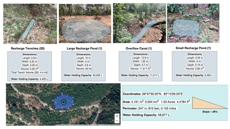
Technologies in Vaishinavi Springshed
Dimensions:
Large Recharge Pond- Length: 10m, Width: 5m, Depth: 0.8 m
Large Pond Volume: 40 cubic meters (m3)

Overflow Canal (narrow pond adjacent to large recharge pond)
Dimensions:
Overflow Canal- Length: 12.9 m, Width: 1.22 m, Depth: 0.7cm
Overflow Canal: 11.017 m3

Small Recharge Pond- Length: 2.34 m, Width: 2 m, Depth: 0.74 m
Small Pond Volume: 3.36 m3

Recharge Trench- Length: 2.5m, Width: 0.25 m, Height: 0.35 m
Trench Volume: 0.22 m3
Total Trench Volume (20): 4.4 m3

Spacing: trenches within 0.5m of each other and <1m spacing between trenches and broadleaf trees and other bushes

Slope: 26%

Water Holding Capacity (L):
Total Capacity of Large Pond: 40,000 L
Total Capacity of Overflow Canal: 11,017 L
Total Capacity of Small Pond: 3,460 L
Total Capacity of Trenches (20): 4,400 L

Total WHC of Technologies: 58,877 L
Total Area of Technologies: 0.5 Hectare

Total Area of Vaishnavi Catchment: ~13 Hectares
Author: Jaclyn Bandy

Establishment and maintenance: activities, inputs and costs

Calculation of inputs and costs
  • Costs are calculated: per Technology unit (unit: 2 Ponds, 1 Overflow Canal, 20 Recharge trenches volume, length: Total Trenches (20): 4.4 m3, Large Recharge Pond: 40 m3, Overflow Canal: 11.017 m3, Small Recharge Pond: 3.36 m3)
  • Currency used for cost calculation: INR
  • Exchange rate (to USD): 1 USD = 70.0 INR
  • Average wage cost of hired labour per day: 400 INR
Most important factors affecting the costs
-Amount of siltation accumulated in the recharge structures (more debris/soil accumulation requires more maintenance and labor days) -Labor availability
Establishment activities
  1. Plan designed by administrative committee of Van Panchayat (Timing/ frequency: Winter 2016)
  2. For technology construction, groups of men and women (8 total per group) were established with their planned working days (Timing/ frequency: Pre-monsoon 2016)
  3. Trenches and recharge ponds were dug on a rotation system by the groups on different days (Timing/ frequency: Pre-monsoon 2016)
  4. Compensation was given to participants upon completion of the project after 20 days work. (Timing/ frequency: Pre-monsoon 2016)
Establishment inputs and costs (per 2 Ponds, 1 Overflow Canal, 20 Recharge trenches)
Specify input Unit Quantity Costs per Unit (INR) Total costs per input (INR) % of costs borne by land users
Labour
Community manual labor person-days 120.0 400.0 48000.0 100.0
Equipment
pick pieces 5.0 300.0 1500.0 100.0
shovel pieces 5.0 500.0 2500.0 100.0
pharuwa (hoe) pieces 4.0 300.0 1200.0 100.0
khanti (digging bar) pieces 3.0 1500.0 4500.0 100.0
hammer pieces 3.0 2000.0 6000.0 100.0
small hammer pieces 3.0 300.0 900.0 100.0
chino (chisel) pieces 4.0 500.0 2000.0 100.0
Construction material
Rocks excavated on site
Total costs for establishment of the Technology 66'600.0
Total costs for establishment of the Technology in USD 951.43
Maintenance activities
  1. Monitoring of the area for any damages or maintenance required (Timing/ frequency: Weekly)
  2. Clearing of debris or filled sediment in pond/trenches/channel (Timing/ frequency: Pre monsoon)
Maintenance inputs and costs (per 2 Ponds, 1 Overflow Canal, 20 Recharge trenches)
Specify input Unit Quantity Costs per Unit (INR) Total costs per input (INR) % of costs borne by land users
Labour
Maintenance Labor person-days 4.0 1600.0 6400.0 100.0
Equipment
Communal equipment (see above for costs)
Total costs for maintenance of the Technology 6'400.0
Total costs for maintenance of the Technology in USD 91.43

Natural environment

Average annual rainfall
  • < 250 mm
  • 251-500 mm
  • 501-750 mm
  • 751-1,000 mm
  • 1,001-1,500 mm
  • 1,501-2,000 mm
  • 2,001-3,000 mm
  • 3,001-4,000 mm
  • > 4,000 mm
Agro-climatic zone
  • humid
  • sub-humid
  • semi-arid
  • arid
Specifications on climate
Average annual rainfall in mm: 1500.0
Monsoon- mid-June to mid-September; July and August are the rainiest months and the temperature is warm and moist; between 70-85% of the annual precipitation occurs in the monsoon season

Seasons
a. Winter or cold weather (mid Dec. - mid March)
b. Summer or hot weather (mid March - mid June)
c. Season of general rains (South - West monsoon season)
d. Season of retreating monsoon (mid September to mid November)
Name of the meteorological station: India Meteorological Department, Meteorological Centre Dehradun
The overall climatic condition in the Pithoragarh district is governed by the southwest monsoon. It has a sub-tropical to temperate climate, with three pronounced seasons; summer, winter, and monsoon. The hilly terrain of the Himalayan region has snow cover and is cold during winter with snowfall normally occurring during the months of December to March.

Temperature- The temperature ranges from 0°C to 10°C in winter and from 8°C to 33°C in summer season. However, there is no meteorological observatory in the district. The account of the climate is based mainly on the records of the observations in the neighboring districts where similar meteorological conditions prevail. Variations in temperature are considerable from place to place and depend upon elevation as well as aspect. As the insolation is intense at high altitudes, in summer temperatures are considerably higher in the open than in the shade.
Slope
  • flat (0-2%)
  • gentle (3-5%)
  • moderate (6-10%)
  • rolling (11-15%)
  • hilly (16-30%)
  • steep (31-60%)
  • very steep (>60%)
Landforms
  • plateau/plains
  • ridges
  • mountain slopes
  • hill slopes
  • footslopes
  • valley floors
Altitude
  • 0-100 m a.s.l.
  • 101-500 m a.s.l.
  • 501-1,000 m a.s.l.
  • 1,001-1,500 m a.s.l.
  • 1,501-2,000 m a.s.l.
  • 2,001-2,500 m a.s.l.
  • 2,501-3,000 m a.s.l.
  • 3,001-4,000 m a.s.l.
  • > 4,000 m a.s.l.
Technology is applied in
  • convex situations
  • concave situations
  • not relevant
Soil depth
  • very shallow (0-20 cm)
  • shallow (21-50 cm)
  • moderately deep (51-80 cm)
  • deep (81-120 cm)
  • very deep (> 120 cm)
Soil texture (topsoil)
  • coarse/ light (sandy)
  • medium (loamy, silty)
  • fine/ heavy (clay)
Soil texture (> 20 cm below surface)
  • coarse/ light (sandy)
  • medium (loamy, silty)
  • fine/ heavy (clay)
Topsoil organic matter content
  • high (>3%)
  • medium (1-3%)
  • low (<1%)
Groundwater table
  • on surface
  • < 5 m
  • 5-50 m
  • > 50 m
Availability of surface water
  • excess
  • good
  • medium
  • poor/ none
Water quality (untreated)
  • good drinking water
  • poor drinking water (treatment required)
  • for agricultural use only (irrigation)
  • unusable
Water quality refers to: ground water
Is salinity a problem?
  • Yes
  • No

Occurrence of flooding
  • Yes
  • No
Species diversity
  • high
  • medium
  • low
Habitat diversity
  • high
  • medium
  • low

Characteristics of land users applying the Technology

Market orientation
  • subsistence (self-supply)
  • mixed (subsistence/ commercial)
  • commercial/ market
Off-farm income
  • less than 10% of all income
  • 10-50% of all income
  • > 50% of all income
Relative level of wealth
  • very poor
  • poor
  • average
  • rich
  • very rich
Level of mechanization
  • manual work
  • animal traction
  • mechanized/ motorized
Sedentary or nomadic
  • Sedentary
  • Semi-nomadic
  • Nomadic
Individuals or groups
  • individual/ household
  • groups/ community
  • cooperative
  • employee (company, government)
Gender
  • women
  • men
Age
  • children
  • youth
  • middle-aged
  • elderly
Area used per household
  • < 0.5 ha
  • 0.5-1 ha
  • 1-2 ha
  • 2-5 ha
  • 5-15 ha
  • 15-50 ha
  • 50-100 ha
  • 100-500 ha
  • 500-1,000 ha
  • 1,000-10,000 ha
  • > 10,000 ha
Scale
  • small-scale
  • medium-scale
  • large-scale
Land ownership
  • state
  • company
  • communal/ village
  • group
  • individual, not titled
  • individual, titled
Land use rights
  • open access (unorganized)
  • communal (organized)
  • leased
  • individual
Water use rights
  • open access (unorganized)
  • communal (organized)
  • leased
  • individual
Access to services and infrastructure
health

poor
good
education

poor
good
technical assistance

poor
good
employment (e.g. off-farm)

poor
good
markets

poor
good
energy

poor
good
roads and transport

poor
good
drinking water and sanitation

poor
good
financial services

poor
good
Comments

The situation of infrastructure is difficult and inconsistent in the hill regions because of the terrain. The major infrastructural issues are drinking water and irrigation facilities, electricity, transportation and communication facilities and social infrastructure (housing and education). As for financial services, only the State Bank of India (SBI) is active in the hill regions where it is trying to achieve the objective of 100% financial inclusion. Some villages mentioned buying into into agricultural insurance in the past, however this was a temporary enterprise and they were never compensated after extreme climatic events that occurred and damaged over 70% of their crop. Though infrastructure and education has generally improved over the years, institutional and marketing networks in the region aimed at supporting hill-farmers are lacking.

Impacts

Socio-economic impacts
fodder production
decreased
increased

fodder quality
decreased
increased

forest/ woodland quality
decreased
increased

land management
hindered
simplified


Constructing these technologies in the forest and within spring catchment areas has supported the village to work collaboratively and increased overall insightfulness to on-and-offsite effects and potentials of SLM.

expenses on agricultural inputs
increased
decreased


Decreased the amount of supplementary fodder required for livestock. The amount of grasses, fodder, and fuelwood has increased with the help of strategic placement of recharge ponds and trenches.

workload
increased
decreased


Less time spent collecting forest resources, as the area where the technology is near the village and supports fodder/fuelwood growth (broadleaf forest/oak nursery area)

Socio-cultural impacts
food security/ self-sufficiency
reduced
improved


Improved self sufficiency of village, as the technology has helped increase their water availability.

health situation
worsened
improved


Water condition has improved. Their is less time spent collecting fodder in the forest, as these technologies have supported fodder tree and grass production.

land use/ water rights
worsened
improved


There is less friction between the villages of Bhurimuni and Nakina. Nakina did not have to go ask for permission to access the Bhurimuni Naula for water during the dry season.

cultural opportunities (eg spiritual, aesthetic, others)
reduced
improved


The improvements of forest resource security and resilience to disasters/climatic extremes have allowed the villagers to spend more of their time building up a communal gathering area for ceremonial events and festivals around the Vaishnavi Temple.

recreational opportunities
reduced
improved


There is more time for the women (1-2 hours saved) as the structural technologies have supported existing vegetation growth. This has reduced the time and distance required for gathering fodder an fuelwood.

community institutions
weakened
strengthened


The partnerships formed between land-users, the Nakina Van Panchayat, the Forest Department and external institutions are leading examples of necessary cooperation between all levels of governance for project harmonization.

SLM/ land degradation knowledge
reduced
improved


People are taking forest management seriously and making innovative plans for further SLM interventions, whether it be community-initiated or with the help of external institutions/agencies.

conflict mitigation
worsened
improved


Increased availability of resources has helped the overall morale of the village. This has further enhanced cooperation for interventions that require participation and effort in the community forest.

situation of socially and economically disadvantaged groups (gender, age, status, ehtnicity etc.)
worsened
improved

Ecological impacts
water quantity
decreased
increased


The technologies act as a water reservoir and improve water holding capacity of the soil by decreasing runoff velocity.

harvesting/ collection of water (runoff, dew, snow, etc)
reduced
improved

surface runoff
increased
decreased

excess water drainage
reduced
improved

groundwater table/ aquifer
lowered
recharge

evaporation
increased
decreased

soil moisture
decreased
increased

soil cover
reduced
improved

soil loss
increased
decreased

soil accumulation
decreased
increased

soil crusting/ sealing
increased
reduced

soil compaction
increased
reduced

soil organic matter/ below ground C
decreased
increased


Micro-catchments accumulate debris/silt washed down from upstream areas. When managed properly, this can function as a beneficial mulch to the soil, improving bioavailabiltiy of nutrients for plants.

vegetation cover
decreased
increased


Improved water availability and thus potential/support for vegetation growth and cover.

biomass/ above ground C
decreased
increased


Improves grasses and vegetation growth, and collects debris/silt from upstream areas.

plant diversity
decreased
increased


Micro-catchments provide water for native grasses, vegetation, and can help with the germination of seeds.

animal diversity
decreased
increased


Micro-catchments provide water and habitat for small animals/birds.

beneficial species (predators, earthworms, pollinators)
decreased
increased


Micro-catchments provide water, habitat, and protection for microorganisms and insect species. They support native grasses and vegetation.

habitat diversity
decreased
increased

landslides/ debris flows
increased
decreased


Decreased surface flow velocity

drought impacts
increased
decreased


Improved groundwater availability and enhanced spring recharge

impacts of cyclones, rain storms
increased
decreased


Erosion impacts from extreme rain storms is reduced by decreasing flow velocity

fire risk
increased
decreased


Area is protected and forest is further enhanced by improved groundwater availability

micro-climate
worsened
improved


Decreased surface temperature due to improved vegetation/biomass, soil cover and water availability.

Off-site impacts
water availability (groundwater, springs)
decreased
increased


Improved spring discharge in the peak dry season

reliable and stable stream flows in dry season (incl. low flows)
reduced
increased


Bhind and Vaishnavi Naulas (springs) have improved discharge in the peak dry season. According to villagers, there was little to no water available in May/June, and since 10 years the flow has returned due to improved forest management in combination with these structural technologies.

downstream flooding (undesired)
increased
reduced


impact of flash flood is minimized

downstream siltation
increased
decreased


Helped slow down sediment and runoff

groundwater/ river pollution
increased
reduced


No direct evidence, but statements from the locals indicate that there are less sediments in the spring water ( due to improved soil infiltration and buffering capacity)

buffering/ filtering capacity (by soil, vegetation, wetlands)
reduced
improved

damage on neighbours' fields
increased
reduced


Less damage from runoff

damage on public/ private infrastructure
increased
reduced


Decreased intensity of runoff on the roadside and settlement below

Cost-benefit analysis

Benefits compared with establishment costs
Short-term returns
very negative
very positive

Long-term returns
very negative
very positive

Benefits compared with maintenance costs
Short-term returns
very negative
very positive

Long-term returns
very negative
very positive

Due to these interventions, spring discharge has improved in the dry season. As villagers are highly reliant on these springs, this has had a huge impact on the community. Establishment and maintenance costs are extremely low compared to the benefits.

Climate change

Gradual climate change
annual temperature increase

not well at all
very well
annual rainfall decrease

not well at all
very well
Intensity of rainfall in wet season increase

not well at all
very well
Climate-related extremes (disasters)
local rainstorm

not well at all
very well
local thunderstorm

not well at all
very well
local hailstorm

not well at all
very well
local snowstorm

not well at all
very well
Answer: not known
local windstorm

not well at all
very well
heatwave

not well at all
very well
drought

not well at all
very well
forest fire

not well at all
very well
flash flood

not well at all
very well
landslide

not well at all
very well

Adoption and adaptation

Percentage of land users in the area who have adopted the Technology
  • single cases/ experimental
  • 1-10%
  • 11-50%
  • > 50%
Of all those who have adopted the Technology, how many have done so without receiving material incentives?
  • 0-10%
  • 11-50%
  • 51-90%
  • 91-100%
Number of households and/ or area covered
In combination with the efforts of the Uttarakhand Forrest Department, under the Tata Water Mission (an initiative of Tata Trusts) 312 villages (out of 1,724) in Pithoragarh district have successfully implemented springshed management projects. They adopted a catchment area approach by identifying sources of springs, understanding their history and reason for decreased discharge before identifying areas that need to be rejuvenated.
Has the Technology been modified recently to adapt to changing conditions?
  • Yes
  • No
To which changing conditions?
  • climatic change/ extremes
  • changing markets
  • labour availability (e.g. due to migration)
Water channels were made to direct runoff into the large recharge pond.

Conclusions and lessons learnt

Strengths: land user's view
  • Reduces erosion, improves catchment of runoff, increases groundwater availability and aids in spring recharge.
  • Supports soil quality and broadleaf forest growth through increased infiltration, improved soil moisture and water availability.
  • Reduces impact of landslides and further downstream damage to settlements (water erosion, siltation)
Strengths: compiler’s or other key resource person’s view
  • Views aligned with land user
Weaknesses/ disadvantages/ risks: land user's viewhow to overcome
  • Structural damage of technologies due to extreme hydrological events Maintenance after such events and application of vegetative measures to complement. Combine with conservation practices like mulching to aid infiltration and deceleration of runoff speed.
  • Function of technologies are lost when there is no rainfall In general, biological interventions are necessary to aid groundwater recharge in the area. However, due to increased vegetation cover, soil moisture and available organic matter can be conserved in times of drought.
Weaknesses/ disadvantages/ risks: compiler’s or other key resource person’s viewhow to overcome
  • Function of the technologies can be compromised with inappropriate design, site selection, or quantification of the area necessary for significant groundwater recharge (e.g. amount of recharge pond and trenches). Training and awareness about the limitations of this technology should be known and made aware by supporting agencies. Selection of catchment areas for springsheds and catchment calculations need to be assessed. Additionally, onsite experts should be provided during implementation.

References

Compiler
  • Jaclyn Bandy
Editors
Reviewer
  • Hanspeter Liniger
  • Rima Mekdaschi Studer
Date of documentation: July 18, 2019
Last update: June 27, 2021
Resource persons
Full description in the WOCAT database
Linked SLM data
Documentation was faciliated by
Institution Project
Links to relevant information which is available online
This work is licensed under Creative Commons Attribution-NonCommercial-ShareaAlike 4.0 International