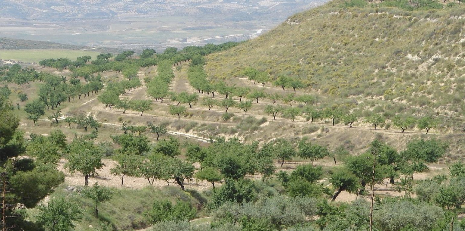
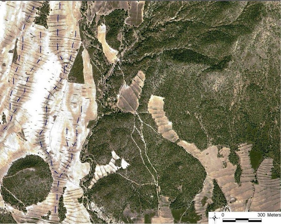
Vegetated earth-banked terraces in an almond orchard (Joris de Vente)

Vegetated earth-banked terraces (Spain)

Terrazas de tierra vegetadas (Spanish)

Description

Earth-banked terraces in cereal and almond cropland covered with drought-resistant shrubs.

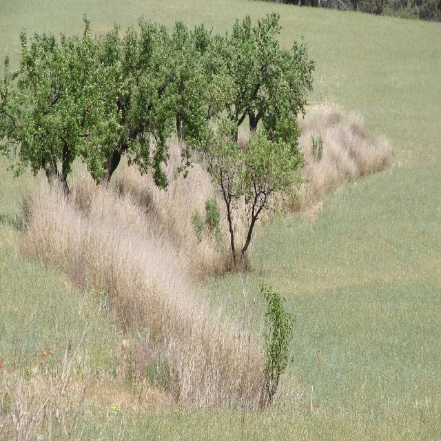
Earth-banked terraces are constructed by carefully removing a superficial soil layer (~10-20 cm) from one part of a field, concentrating it on the lower end of that field in order to reduce slope gradient and length. Another terrace is created directly downslope to form a cascade of terraces. Terrace risers have to be of restricted height (~50-150 cm) to prevent steep and unstable terraces. Stones from the fields can be used to reinforce the terrace ridge. After terrace construction, fields should be gently sloping (<3%) in the direction of the main slope. The distance between terraces must be enough to allow tractor movement during normal cultivation activities and it depends also on the slope gradient. The steeper the slope, the shorter is the distance between terraces. Terraces reduce the formation of gullies and retain water from upslope. The terraces are made with locally available machinery (tractor, small bulldozer). The terrace ridges are optimal locations to plant olives, almonds or fruit trees. Moreover, to be most effective, the terrace ridges are vegetated with shrubs adapted to semi-arid conditions and with a good surface cover (>~30%) throughout the year (e.g. Stipa tenacisima, Rosmarinus officinalis, Thymus vulgaris, Ulex parviflorus, Rhamnus lycioides, Pistacia lentiscus). Natural regeneration of vegetation is allowed without limitation on the terrace ridges, so no herbicide application or burning are carried out to remove weeds. Where possible, regeneration should be stimulated by planting the same adapted species in at least 25% of the terrace ridge. Optionally, in the other 75% of the terrace ridge, cereals or other leguminous species can be sown, but should not be harvested or used for grazing.

Purpose of the Technology: This technology reduces flooding, damage to infrastructure and siltation of water reservoirs, while maintaining (or slightly increasing) crop productivity. This is achieved by reducing runoff, soil erosion and hydraulic connectivity through a decreased slope gradient and an increased vegetation cover. The terrace ridge functions as a sink for runoff within fields and reduces runoff velocity. The vegetation leads to increased soil organic matter content below plants, producing an improved soil structure and a higher infiltration capacity. The use of stones from the fields to reinforce the terraces is optional, but facilitates crop production in the fields and makes the ridges more resistant to higher runoff velocities. The technology requires an initial investment in the construction of the terraces. Terraces can best be located on thalwegs and on areas where gully formation is often observed. Maintenance consists of filling up possible bank gullies developed in the terraces after important rainfall events and, if needed, substitute decayed shrubs with new ones.

Natural / human environment: The technology is generally applied on soils of shallow to medium depth (20 – 60 cm), and slopes are gentle to moderate (5-15%). The climate is semi-arid with a mean annual rainfall around 300 mm. Droughts, peaking in summer commonly last for more than 4-5 months. Annual potential evapotranspiration rates larger than 1000 mm are common. The production system is highly mechanized and market-oriented but depends strongly on agricultural subsidies. All cropland is privately-owned.

Location

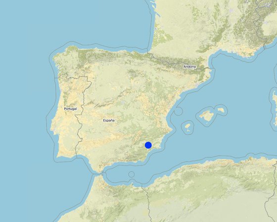
Location: Guadalentin catchment, Murcia, Spain

No. of Technology sites analysed:

Geo-reference of selected sites
  • -1.7076, 37.7931

Spread of the Technology: evenly spread over an area (approx. 10-100 km2)

In a permanently protected area?:

Date of implementation: more than 50 years ago (traditional)

Type of introduction
Vegetated earthen-terraces. Terrace slopes are vegetated with drought resistant shrub vegetation through natural regeneration, and some are used for almond trees. The photo lower right shows an aerial photograph (1997) of intensely terraced slopes with ea (Joris de Vente (Murcia, Spain))
Vegetated earth-banked terraces in a cereal field with almonds on the terrace ridge (Joris de Vente)

Classification of the Technology

Main purpose
  • improve production
  • reduce, prevent, restore land degradation
  • conserve ecosystem
  • protect a watershed/ downstream areas – in combination with other Technologies
  • preserve/ improve biodiversity
  • reduce risk of disasters
  • adapt to climate change/ extremes and its impacts
  • mitigate climate change and its impacts
  • create beneficial economic impact
  • create beneficial social impact
Land use
Land use mixed within the same land unit: Yes - Agroforestry

  • Cropland
    • Annual cropping
    • Tree and shrub cropping: tree nuts (brazil nuts, pistachio, walnuts, almonds, etc.)
    Number of growing seasons per year: 1
  • Grazing land
  • Forest/ woodlands
    • (Semi-)natural forests/ woodlands
Water supply
  • rainfed
  • mixed rainfed-irrigated
  • full irrigation

Purpose related to land degradation
  • prevent land degradation
  • reduce land degradation
  • restore/ rehabilitate severely degraded land
  • adapt to land degradation
  • not applicable
Degradation addressed
  • soil erosion by water - Wt: loss of topsoil/ surface erosion, Wg: gully erosion/ gullying, Wo: offsite degradation effects
  • water degradation - Ha: aridification
SLM group
  • improved ground/ vegetation cover
  • cross-slope measure
SLM measures
  • vegetative measures - V1: Tree and shrub cover, V2: Grasses and perennial herbaceous plants
  • structural measures - S1: Terraces

Technical drawing

Technical specifications
Quickbird satellite image showing the concentration of terraces along natural drainage lines (thalwegs) where runoff concentrates. Drainage lines are indicated with dotted lines.

Location: Torrealvillla. Murcia

Date: Satellite image 2003

Technical knowledge required for field staff / advisors: moderate (Design of the terraces and selection of the location requires some technical knowledge.)

Technical knowledge required for land users: low (Practical implementation of the terraces does not require a high level of knowledge)

Main technical functions: control of dispersed runoff: retain / trap, control of dispersed runoff: impede / retard, control of concentrated runoff: retain / trap, control of concentrated runoff: impede / retard, reduction of slope angle, increase of infiltration, increase / maintain water stored in soil

Secondary technical functions: reduction of slope length, improvement of ground cover, stabilisation of soil (eg by tree roots against land slides), increase in organic matter, water harvesting / increase water supply, sediment retention / trapping, sediment harvesting, spatial arrangement and diversification of land use

Aligned: -contour
Vegetative material: F : fruit trees / shrubs
Number of plants per (ha): 42
Vertical interval between rows / strips / blocks (m): 1
Spacing between rows / strips / blocks (m): 30-100
Vertical interval within rows / strips / blocks (m): 0.5-7
Width within rows / strips / blocks (m): 2

Vegetative measure: alligned: contour
Vegetative material: G : grass
Number of plants per (ha): >30% cover
Vertical interval between rows / strips / blocks (m): 1
Spacing between rows / strips / blocks (m): 30-100
Vertical interval within rows / strips / blocks (m): 0.5
Width within rows / strips / blocks (m): 2

Vegetative measure: Vegetative material: G : grass

Vegetative measure: Vegetative material: G : grass

Vegetative measure: Vegetative material: G : grass

Fruit trees / shrubs species: natural regeneration of shrubs with possible additional plantation of almond trees and/or woody shru

Grass species: Natural regeneration assisted by seeding of legiminous species and cereals

Slope (which determines the spacing indicated above): 10.00%

Terrace: forward sloping
Vertical interval between structures (m): 1
Spacing between structures (m): 30-100
Height of bunds/banks/others (m): 0.5-1.5
Width of bunds/banks/others (m): 2
Length of bunds/banks/others (m): 50-200

Construction material (stone): Only when many stones are present in the fields

Slope (which determines the spacing indicated above): 5-15%

If the original slope has changed as a result of the Technology, the slope today is: <3%

Lateral gradient along the structure: 0%

Vegetation is used for stabilisation of structures.
Author: Joris de Vente

Establishment and maintenance: activities, inputs and costs

Calculation of inputs and costs
  • Costs are calculated:
  • Currency used for cost calculation: EURO
  • Exchange rate (to USD): 1 USD = 0.63 EURO
  • Average wage cost of hired labour per day: 79.00
Most important factors affecting the costs
Price of fuel and labour are the most important determinants of the costs.
Establishment activities
  1. Plantation of shrubs and cereals or Leguminous species (optional) (Timing/ frequency: Autumn - winter)
  2. Construction of terraces (Timing/ frequency: autumn or winter)
Establishment inputs and costs
Specify input Unit Quantity Costs per Unit (EURO) Total costs per input (EURO) % of costs borne by land users
Labour
Labour ha 1.0 270.0 270.0 10.0
Equipment
Machine use ha 1.0 428.0 428.0 12.0
Plant material
shrub seedlings and seeds ha 1.0 218.0 218.0 10.0
Total costs for establishment of the Technology 916.0
Total costs for establishment of the Technology in USD 1'453.97
Maintenance activities
  1. Replace died shrubs (optional) (Timing/ frequency: autumn-winter)
  2. Filling up bank gullies in terraces (Timing/ frequency: twice a year or after heavy rainstorms)
Maintenance inputs and costs
Specify input Unit Quantity Costs per Unit (EURO) Total costs per input (EURO) % of costs borne by land users
Labour
Labour ha 1.0 28.0 28.0 10.0
Equipment
Machine use ha 1.0 24.0 24.0 10.0
Plant material
Shrub seedlings and seeds ha 1.0 22.0 22.0 10.0
Total costs for maintenance of the Technology 74.0
Total costs for maintenance of the Technology in USD 117.46

Natural environment

Average annual rainfall
  • < 250 mm
  • 251-500 mm
  • 501-750 mm
  • 751-1,000 mm
  • 1,001-1,500 mm
  • 1,501-2,000 mm
  • 2,001-3,000 mm
  • 3,001-4,000 mm
  • > 4,000 mm
Agro-climatic zone
  • humid
  • sub-humid
  • semi-arid
  • arid
Specifications on climate
Average annual rainfall in mm: 300.0
Dry period in summer during 3-4 months (June – August/September)
Thermal climate class: subtropics

Thermal climate class: temperate. The higher parts are generally somewhat colder
Slope
  • flat (0-2%)
  • gentle (3-5%)
  • moderate (6-10%)
  • rolling (11-15%)
  • hilly (16-30%)
  • steep (31-60%)
  • very steep (>60%)
Landforms
  • plateau/plains
  • ridges
  • mountain slopes
  • hill slopes
  • footslopes
  • valley floors
Altitude
  • 0-100 m a.s.l.
  • 101-500 m a.s.l.
  • 501-1,000 m a.s.l.
  • 1,001-1,500 m a.s.l.
  • 1,501-2,000 m a.s.l.
  • 2,001-2,500 m a.s.l.
  • 2,501-3,000 m a.s.l.
  • 3,001-4,000 m a.s.l.
  • > 4,000 m a.s.l.
Technology is applied in
  • convex situations
  • concave situations
  • not relevant
Soil depth
  • very shallow (0-20 cm)
  • shallow (21-50 cm)
  • moderately deep (51-80 cm)
  • deep (81-120 cm)
  • very deep (> 120 cm)
Soil texture (topsoil)
  • coarse/ light (sandy)
  • medium (loamy, silty)
  • fine/ heavy (clay)
Soil texture (> 20 cm below surface)
  • coarse/ light (sandy)
  • medium (loamy, silty)
  • fine/ heavy (clay)
Topsoil organic matter content
  • high (>3%)
  • medium (1-3%)
  • low (<1%)
Groundwater table
  • on surface
  • < 5 m
  • 5-50 m
  • > 50 m
Availability of surface water
  • excess
  • good
  • medium
  • poor/ none
Water quality (untreated)
  • good drinking water
  • poor drinking water (treatment required)
  • for agricultural use only (irrigation)
  • unusable
Water quality refers to:
Is salinity a problem?
  • Yes
  • No

Occurrence of flooding
  • Yes
  • No
Species diversity
  • high
  • medium
  • low
Habitat diversity
  • high
  • medium
  • low

Characteristics of land users applying the Technology

Market orientation
  • subsistence (self-supply)
  • mixed (subsistence/ commercial)
  • commercial/ market
Off-farm income
  • less than 10% of all income
  • 10-50% of all income
  • > 50% of all income
Relative level of wealth
  • very poor
  • poor
  • average
  • rich
  • very rich
Level of mechanization
  • manual work
  • animal traction
  • mechanized/ motorized
Sedentary or nomadic
  • Sedentary
  • Semi-nomadic
  • Nomadic
Individuals or groups
  • individual/ household
  • groups/ community
  • cooperative
  • employee (company, government)
Gender
  • women
  • men
Age
  • children
  • youth
  • middle-aged
  • elderly
Area used per household
  • < 0.5 ha
  • 0.5-1 ha
  • 1-2 ha
  • 2-5 ha
  • 5-15 ha
  • 15-50 ha
  • 50-100 ha
  • 100-500 ha
  • 500-1,000 ha
  • 1,000-10,000 ha
  • > 10,000 ha
Scale
  • small-scale
  • medium-scale
  • large-scale
Land ownership
  • state
  • company
  • communal/ village
  • group
  • individual, not titled
  • individual, titled
Land use rights
  • open access (unorganized)
  • communal (organized)
  • leased
  • individual
Water use rights
  • open access (unorganized)
  • communal (organized)
  • leased
  • individual
Access to services and infrastructure
health

poor
x
good
education

poor
x
good
technical assistance

poor
x
good
employment (e.g. off-farm)

poor
x
good
markets

poor
x
good
energy

poor
x
good
roads and transport

poor
x
good
drinking water and sanitation

poor
x
good
financial services

poor
x
good

Impacts

Socio-economic impacts
Crop production
decreased
x
increased


Depending on local conditions yield may be the same or increase slightly

land management
hindered
x
simplified


Field paths become shorter, so more tractor movement is required (not more kilometres!)

expenses on agricultural inputs
increased
x
decreased


Implementation of terraces is considered relatively expensive

farm income
decreased
x
increased


Depends on crop yield.

workload
increased
x
decreased


Less damage to fields due to less gully formation

Socio-cultural impacts
SLM/ land degradation knowledge
reduced
x
improved

conflict mitigation
worsened
x
improved


Less damage to neighbours fields by gullies and flooding

Improved livelihoods and human well-being
decreased
x
increased


There is less damage to fields and to infrastructure due to gully formation and flooding.

Ecological impacts
harvesting/ collection of water (runoff, dew, snow, etc)
reduced
x
improved


On the long term higher infiltration capacity of the soil

surface runoff
increased
x
decreased

groundwater table/ aquifer
lowered
x
recharge

soil moisture
decreased
x
increased

soil cover
reduced
x
improved


Vegetation on the terraces increases vegetation cover

soil loss
increased
x
decreased

soil organic matter/ below ground C
decreased
x
increased


Provided by the vegetation on the terraces

biomass/ above ground C
decreased
x
increased


Provided by the vegetation on the terraces

plant diversity
decreased
x
increased

animal diversity
decreased
x
increased


Terraces provide corridors connecting fields and provide shelter

beneficial species (predators, earthworms, pollinators)
decreased
x
increased

habitat diversity
decreased
x
increased

Off-site impacts
downstream flooding (undesired)
increased
x
reduced

downstream siltation
increased
x
decreased

buffering/ filtering capacity (by soil, vegetation, wetlands)
reduced
x
improved

damage on neighbours' fields
increased
x
reduced

damage on public/ private infrastructure
increased
x
reduced

Cost-benefit analysis

Benefits compared with establishment costs
Short-term returns
very negative
x
very positive

Long-term returns
very negative
x
very positive

Benefits compared with maintenance costs
Short-term returns
very negative
x
very positive

Long-term returns
very negative
x
very positive

Implementation of the terraces is relatively expensive. Additionally planting of shrubs is also relatively expensive and requires a subsidy. Once installed, maintenance is not expensive and pays off because of less damage to fields and infrastructure.

Climate change

Gradual climate change
annual temperature increase

not well at all
x
very well

Adoption and adaptation

Percentage of land users in the area who have adopted the Technology
  • single cases/ experimental
  • 1-10%
  • 11-50%
  • > 50%
Of all those who have adopted the Technology, how many have done so without receiving material incentives?
  • 0-10%
  • 11-50%
  • 51-90%
  • 91-100%
Has the Technology been modified recently to adapt to changing conditions?
  • Yes
  • No
To which changing conditions?
  • climatic change/ extremes
  • changing markets
  • labour availability (e.g. due to migration)

Conclusions and lessons learnt

Strengths: land user's view
  • The terraces prevent gully formation and damage to the fields and to their neighbours

    How can they be sustained / enhanced? maintenance is needed and should be promoted.
Strengths: compiler’s or other key resource person’s view
  • This technology is very effective at reducing surface runoff and erosion by reducing slope gradients and connectivity. In addition, it has a water harvesting effect. So it reduces on-site and off-site erosion problems and potentially increases water retention in the fields.

    How can they be sustained / enhanced? The technology can be enhanced by providing more info and publicity so that existing terraces are maintained.
Weaknesses/ disadvantages/ risks: land user's viewhow to overcome
  • It is considered relatively expensive to implement and particularly the optional planting of woody species is considered complicated in dry years Subsidies for terrace construction and planting of woody species as well as cooperation between farmers to reduce costs of maintenance when subsidies stop.
Weaknesses/ disadvantages/ risks: compiler’s or other key resource person’s viewhow to overcome
  • The technology does not significantly improve farm income and has a significant implementation cost. Provide information on all the advantages that include many costs for society (including floods, reservoir siltation etc.). The subsidy for implementation already solves the problem of implementation costs.

References

Compiler
  • Joris De Vente
Editors
Reviewer
  • Deborah Niggli
  • Alexandra Gavilano
Date of documentation: July 1, 2011
Last update: July 31, 2019
Resource persons
Full description in the WOCAT database
Linked SLM data
Documentation was faciliated by
Institution Project
Key references
  • Garcia-Fayos, P. and Gasque, M., 2002. Consequences of a severe drought on spatial patterns of woody plants in a two-phase mosaic steppe of Stipa tenacissima L. Journal of Arid Environments, 52(2): 199-208.: internet
  • Hooke, J.M., 2006. Human impacts on fluvial systems in the Mediterranean region. Geomorphology, 79(3-4): 311-335.: internet
  • Kirkby, M.J., Bracken, L.J. and Shannon, J., 2005. The influence of rainfall distribution and morphological factors on runoff delivery from dryland catchments in SE Spain. CATENA, 62(2-3): 136-156.: internet
Links to relevant information which is available online
This work is licensed under Creative Commons Attribution-NonCommercial-ShareaAlike 4.0 International