Irrigated agro-biodiversity system in arid high mountain area
(Tajikistan)
Description
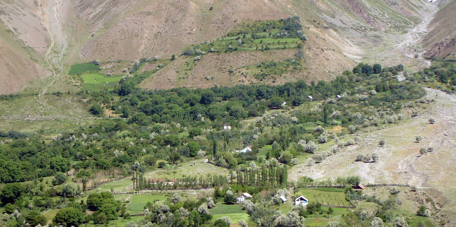
An individual farmer family, has changed an overgrazed pasture area on a steep slope in the upper part of the village into an irrigated agro-biodiversity system, by constructing an irrigation canal, by tilling and removing stones from the terraces for crop production and afforesting the surrounding area with fruit trees and bushes.
Establishment / maintenance activities and inputs: The site was established in 1989, with the construction of an irrigation canal. The canal brings water from a small watershed and the slowly melting snow fields within. In years with limited snowfall, the water is insufficient for irrigation throughout the summer months.It is a open, mud canal, 730 m long. When establishing new cropland, removal of stones from the plots is the most laborious part of the work. After an initial removal of stones, the land is tilled and appearing stones are again removed. This process is repeated several times.
Year round maintenance work is required to keep the canal functioning. Maintenance work on the cropland includes stone removal, manuring of potatoes fields, weeding and tilling.
Location
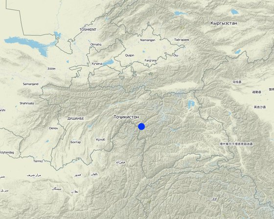
Location: Vanj / Udob / Trit, GBAO, Tajikistan
No. of Technology sites analysed:
Geo-reference of selected sites
Spread of the Technology: evenly spread over an area (approx. < 0.1 km2 (10 ha))
In a permanently protected area?:
Date of implementation: more than 50 years ago (traditional)
Type of introduction
-
through land users' innovation
-
as part of a traditional system (> 50 years)
-
during experiments/ research
-
through projects/ external interventions
-
Classification of the Technology
Main purpose
-
improve production
-
reduce, prevent, restore land degradation
-
conserve ecosystem
-
protect a watershed/ downstream areas – in combination with other Technologies
-
preserve/ improve biodiversity
-
reduce risk of disasters
-
adapt to climate change/ extremes and its impacts
-
mitigate climate change and its impacts
-
create beneficial economic impact
-
create beneficial social impact
Land use
Land use mixed within the same land unit: Yes - Agroforestry
-
Cropland
- Annual cropping: cereals - wheat (spring), cereals - wheat (winter), fodder crops - alfalfa, root/tuber crops - potatoes, vegetables, sea-buckthorn
- Perennial (non-woody) cropping
- Tree and shrub cropping: pome fruits (apples, pears, quinces, etc.), stone fruits (peach, apricot, cherry, plum, etc), tree nuts (brazil nuts, pistachio, walnuts, almonds, etc.)
Number of growing seasons per year: 1
-
Forest/ woodlandsProducts and services: Fruits and nuts
Water supply
-
rainfed
-
mixed rainfed-irrigated
-
full irrigation
Purpose related to land degradation
-
prevent land degradation
-
reduce land degradation
-
restore/ rehabilitate severely degraded land
-
adapt to land degradation
-
not applicable
Degradation addressed
-
soil erosion by water - Wt: loss of topsoil/ surface erosion, Wm: mass movements/ landslides
-
chemical soil deterioration - Cn: fertility decline and reduced organic matter content (not caused by erosion)
-
physical soil deterioration - Pc: compaction
-
biological degradation - Bc: reduction of vegetation cover, Bh: loss of habitats, Bq: quantity/ biomass decline, Bs: quality and species composition/ diversity decline, Bl: loss of soil life
SLM group
-
agroforestry
-
cross-slope measure
-
irrigation management (incl. water supply, drainage)
SLM measures
-
agronomic measures - A1: Vegetation/ soil cover, A2: Organic matter/ soil fertility
-
vegetative measures - V1: Tree and shrub cover, V2: Grasses and perennial herbaceous plants
-
structural measures - S1: Terraces
-
management measures - M1: Change of land use type, M2: Change of management/ intensity level, M3: Layout according to natural and human environment
Technical drawing
Technical specifications
Establishment and maintenance: activities, inputs and costs
Calculation of inputs and costs
- Costs are calculated:
- Currency used for cost calculation: Tajik Somoni
- Exchange rate (to USD): 1 USD = 4.4 Tajik Somoni
- Average wage cost of hired labour per day: 30.00
Most important factors affecting the costs
With regard to the establishment costs, the most determining factors are: the distance to the creek from where water is channeled away and the steepness of the slope and amount of stones when preparing the land for annual cropping. With regard to the maintenance costs it is the exposure of the water channel to rock fall and small land slides.
Establishment activities
-
Planting of willows, cherry, pears (Timing/ frequency: spring)
-
Construction of irrigation canal (Timing/ frequency: autumn)
-
Construction of on-farm water distribution network (Timing/ frequency: spring)
-
Alfa-alfa seeds (12kg/ha) (Timing/ frequency: for 4 years, then can produce own seeds)
Establishment inputs and costs
| Specify input |
Unit |
Quantity |
Costs per Unit (Tajik Somoni) |
Total costs per input (Tajik Somoni) |
% of costs borne by land users |
|
Labour
|
| Planting of willows, cherry, pears |
Persons/day |
1.0 |
|
|
100.0 |
| Construction irrigation canal |
Persons/day |
100.0 |
30.0 |
3000.0 |
100.0 |
| Construction of on-farm water distribution network |
Persons/day |
30.0 |
30.0 |
900.0 |
|
|
Plant material
|
| Alfa-alfa seeds |
kg/ha |
6.0 |
20.0 |
120.0 |
100.0 |
| Total costs for establishment of the Technology |
4'020.0 |
|
| Total costs for establishment of the Technology in USD |
913.64 |
|
Maintenance activities
-
Wheat (barley) sowing (Timing/ frequency: anually)
-
Wheat (barley) sowing (Timing/ frequency: None)
-
Tilling potato fields (Timing/ frequency: 3 times per growing season)
-
Irrigating wheat (barley, alfa-alfa) (Timing/ frequency: times per growing season)
-
Planting potato (Timing/ frequency: during planting)
-
Planting potato (Timing/ frequency: None)
-
Applying fertilizer to wheat fields (Timing/ frequency: 3 times per growing period)
-
Maintenance of canal and on-farm water distribution network (Timing/ frequency: spring and after rains)
Maintenance inputs and costs
| Specify input |
Unit |
Quantity |
Costs per Unit (Tajik Somoni) |
Total costs per input (Tajik Somoni) |
% of costs borne by land users |
|
Labour
|
| Sowing wheat with ochses |
Persons/day |
1.0 |
40.0 |
40.0 |
100.0 |
| Tilling with ochses |
Persons/day |
6.0 |
40.0 |
240.0 |
|
| Irrigating wheat, barley alfalfa |
Persons/day |
6.0 |
30.0 |
180.0 |
|
| Planting potatoe |
Persons/day |
8.0 |
30.0 |
240.0 |
|
|
Equipment
|
| Ochses for wheat sowing |
Ochses/ha |
2.0 |
50.0 |
100.0 |
100.0 |
| Ochses for potatoe tilling |
Ochses/ha |
6.0 |
30.0 |
180.0 |
100.0 |
| Donkey for carrying dung to the fields |
loads |
120.0 |
0.66666 |
80.0 |
|
| Labour: Going with donkeys |
Persons/day |
8.0 |
40.0 |
320.0 |
|
|
Plant material
|
| Wheat seeds |
kg |
200.0 |
1.2 |
240.0 |
|
|
Fertilizers and biocides
|
| Compost/manure |
tons |
12.0 |
50.0 |
600.0 |
|
| Poatoe seedling |
kg |
800.0 |
1.0 |
800.0 |
|
| Fertilizer for wheats |
kg |
140.0 |
0.58571 |
82.0 |
|
| Total costs for maintenance of the Technology |
3'102.0 |
|
| Total costs for maintenance of the Technology in USD |
705.0 |
|
Natural environment
Average annual rainfall
-
< 250 mm
-
251-500 mm
-
501-750 mm
-
751-1,000 mm
-
1,001-1,500 mm
-
1,501-2,000 mm
-
2,001-3,000 mm
-
3,001-4,000 mm
-
> 4,000 mm
Agro-climatic zone
-
humid
-
sub-humid
-
semi-arid
-
arid
Specifications on climate
Most of the precipitation consits of snow, the main rainfall period is March / April
Thermal climate class: temperate. high mountain area
A2240 m asl
gricultural areas need irrigation, which is supplied by snow and glacier melt
Slope
-
flat (0-2%)
-
gentle (3-5%)
-
moderate (6-10%)
-
rolling (11-15%)
-
hilly (16-30%)
-
steep (31-60%)
-
very steep (>60%)
Landforms
-
plateau/plains
-
ridges
-
mountain slopes
-
hill slopes
-
footslopes
-
valley floors
Altitude
-
0-100 m a.s.l.
-
101-500 m a.s.l.
-
501-1,000 m a.s.l.
-
1,001-1,500 m a.s.l.
-
1,501-2,000 m a.s.l.
-
2,001-2,500 m a.s.l.
-
2,501-3,000 m a.s.l.
-
3,001-4,000 m a.s.l.
-
> 4,000 m a.s.l.
Technology is applied in
-
convex situations
-
concave situations
-
not relevant
Soil depth
-
very shallow (0-20 cm)
-
shallow (21-50 cm)
-
moderately deep (51-80 cm)
-
deep (81-120 cm)
-
very deep (> 120 cm)
Soil texture (topsoil)
-
coarse/ light (sandy)
-
medium (loamy, silty)
-
fine/ heavy (clay)
Soil texture (> 20 cm below surface)
-
coarse/ light (sandy)
-
medium (loamy, silty)
-
fine/ heavy (clay)
Topsoil organic matter content
-
high (>3%)
-
medium (1-3%)
-
low (<1%)
Groundwater table
-
on surface
-
< 5 m
-
5-50 m
-
> 50 m
Availability of surface water
-
excess
-
good
-
medium
-
poor/ none
Water quality (untreated)
-
good drinking water
-
poor drinking water (treatment required)
-
for agricultural use only (irrigation)
-
unusable
Water quality refers to:
Is salinity a problem?
Occurrence of flooding
Characteristics of land users applying the Technology
Market orientation
-
subsistence (self-supply)
-
mixed (subsistence/ commercial)
-
commercial/ market
Off-farm income
-
less than 10% of all income
-
10-50% of all income
-
> 50% of all income
Relative level of wealth
-
very poor
-
poor
-
average
-
rich
-
very rich
Level of mechanization
-
manual work
-
animal traction
-
mechanized/ motorized
Sedentary or nomadic
-
Sedentary
-
Semi-nomadic
-
Nomadic
Individuals or groups
-
individual/ household
-
groups/ community
-
cooperative
-
employee (company, government)
Age
-
children
-
youth
-
middle-aged
-
elderly
Area used per household
-
< 0.5 ha
-
0.5-1 ha
-
1-2 ha
-
2-5 ha
-
5-15 ha
-
15-50 ha
-
50-100 ha
-
100-500 ha
-
500-1,000 ha
-
1,000-10,000 ha
-
> 10,000 ha
Scale
-
small-scale
-
medium-scale
-
large-scale
Land ownership
-
state
-
company
-
communal/ village
-
group
-
individual, not titled
-
individual, titled
Land use rights
-
open access (unorganized)
-
communal (organized)
-
leased
-
individual
Water use rights
-
open access (unorganized)
-
communal (organized)
-
leased
-
individual
Access to services and infrastructure
employment (e.g. off-farm)
drinking water and sanitation
Cost-benefit analysis
Benefits compared with establishment costs
Benefits compared with maintenance costs
Climate change
Gradual climate change
annual temperature increase
not well at all
very well
Climate-related extremes (disasters)
not well at all
very well
not well at all
very well
not well at all
very well
not well at all
very well
Other climate-related consequences
not well at all
very well
Adoption and adaptation
Percentage of land users in the area who have adopted the Technology
-
single cases/ experimental
-
1-10%
-
11-50%
-
> 50%
Of all those who have adopted the Technology, how many have done so without receiving material incentives?
-
0-10%
-
11-50%
-
51-90%
-
91-100%
Number of households and/ or area covered
1 Household
Has the Technology been modified recently to adapt to changing conditions?
To which changing conditions?
-
climatic change/ extremes
-
changing markets
-
labour availability (e.g. due to migration)
Conclusions and lessons learnt
Strengths: land user's view
Strengths: compiler’s or other key resource person’s view
Weaknesses/ disadvantages/ risks: land user's viewhow to overcome
Weaknesses/ disadvantages/ risks: compiler’s or other key resource person’s viewhow to overcome
References
Reviewer
-
David Streiff
-
Alexandra Gavilano
Date of documentation: Jan. 25, 2011
Last update: Aug. 4, 2019
Resource persons
-
Gulniso Nekushoeva - SLM specialist
-
Bettina Wolfgramm - SLM specialist
-
Pjotr M Sosin - SLM specialist
Full description in the WOCAT database
Documentation was faciliated by
Institution
- CDE Centre for Development and Environment (CDE Centre for Development and Environment) - Switzerland
- Golden Valley agricultural research trust (Golden Valley agricultural research trust) - Zambia
- Tajik Soil Insitute (Tajik Soil Institute) - Tajikistan
Project