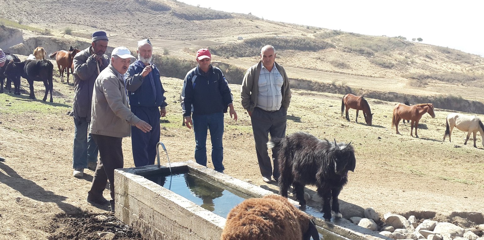
Herders and animals coming to drink at the water point in upper pasture zone of Dehbaland village. (Nicole Stolz)

Water points for livestock in daily pastures (Tajikistan)

Нуқтаи обнушии чорво

Description

Water points for daily use in pastures, reducing erosion and enhancing productivity of cattle and other livestock.

Bringing water from springs or other sources to water points in pastures greatly increases livestock productivity and improves reproductive performance. Difficult and distant access to water exhausts the animals, reducing production of meat and milk and reproductive capacities by up to 50%.
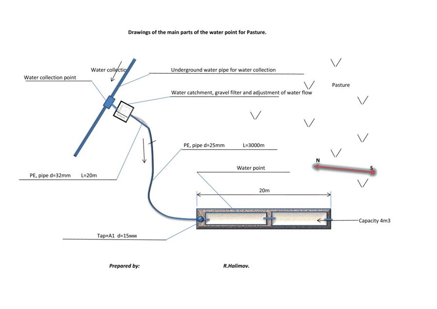
By providing water points in pastures, negative effects on livestock productivity can be reduced to a minimum. In order to implement the technology, water sources with perennial flow have to be identified with the shortest possible distance to and from the different grazing grounds. As a next step, in Tajikistan, water and land ownership and user rights must be regulated. Rights to pasture users are either given by the community or individual land and water owners. If the water source and a location for construction are found within a reasonable distance of the different pasture grounds, a drinking water system for livestock can be designed and constructed. Construction involves spring water collection , laying of pipes
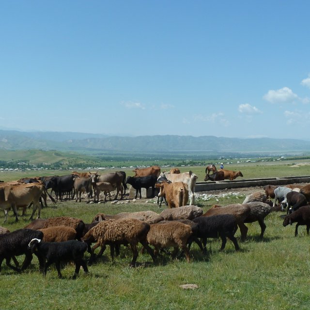
and finally installation of the water point. Besides the direct benefits (i.e. increased productivity and reproduction), the water points in the pastures reduce erosion from cattle tracks in often critical locations such as steep slopes surrounding springs. Water points also protect springs from being destroyed or spoiled by the animals. Thus the technology has a risk reduction benefit. A potential negative effect of the technology is a reduction of biodiversity, as extracting water from catchment springs may result in fewer natural fauna and flora in the micro-environments around the springs.

Location

Location: Muminabad, Dehbaland, Khatlon, Tajikistan

No. of Technology sites analysed: 10-100 sites

Geo-reference of selected sites
  • 70.07469, 38.04565
  • 70.05, 38.05
  • 70.06, 38.09
  • 70.09, 38.05

Spread of the Technology: applied at specific points/ concentrated on a small area

In a permanently protected area?:

Date of implementation: 2014

Type of introduction
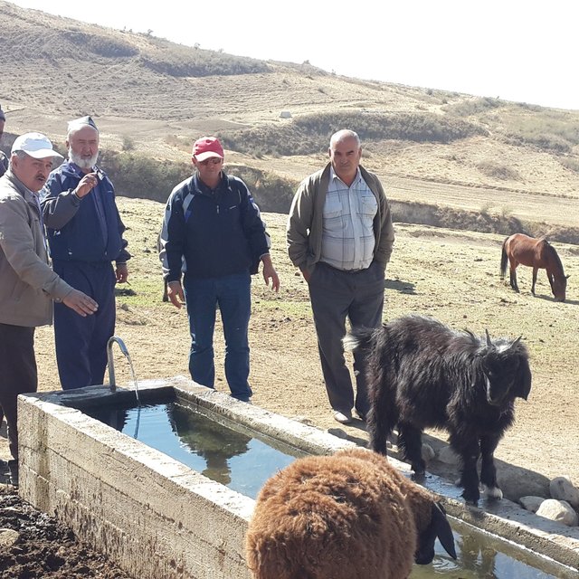
Water point in upper pasture of Dehbaland village (Nicole Stolz)
Animals drinking at a water point (Nicole Stolz)

Classification of the Technology

Main purpose
  • improve production
  • reduce, prevent, restore land degradation
  • conserve ecosystem
  • protect a watershed/ downstream areas – in combination with other Technologies
  • preserve/ improve biodiversity
  • reduce risk of disasters
  • adapt to climate change/ extremes and its impacts
  • mitigate climate change and its impacts
  • create beneficial economic impact
  • create beneficial social impact
Land use

  • Grazing land
    • Semi-nomadic pastoralism

Water supply
  • rainfed
  • mixed rainfed-irrigated
  • full irrigation

Purpose related to land degradation
  • prevent land degradation
  • reduce land degradation
  • restore/ rehabilitate severely degraded land
  • adapt to land degradation
  • not applicable
Degradation addressed
  • soil erosion by water - Wt: loss of topsoil/ surface erosion, Wg: gully erosion/ gullying
  • soil erosion by wind - Et: loss of topsoil
  • physical soil deterioration - Pc: compaction, Pu: loss of bio-productive function due to other activities
SLM group
  • pastoralism and grazing land management
  • surface water management (spring, river, lakes, sea)
SLM measures
  • structural measures - S7: Water harvesting/ supply/ irrigation equipment

Technical drawing

Technical specifications
Water is collected in underground pipes and from surface runoff, passes through a filter which additionally regulates the flow and is led to the water point structure. The length of the tubes (see drawing) allows for collecting water from a surface of several hectars. The structure is made of concrete and consists of two basins, holding together approx. 4m3 of water.
Author: R. Halimov

Establishment and maintenance: activities, inputs and costs

Calculation of inputs and costs
  • Costs are calculated: per Technology unit (unit: one water point volume, length: 18m, 4,5m3)
  • Currency used for cost calculation: Tajik Somoni
  • Exchange rate (to USD): 1 USD = 8.0 Tajik Somoni
  • Average wage cost of hired labour per day: 45 Somoni (5.5 USD per day)
Most important factors affecting the costs
Cost for pipes and cement, i.e. the distance of the next suitable spring to the pasture area; land ownership: state owned land rented to the Pasture Union
Establishment activities
  1. Identify water sources (spring detection) (Timing/ frequency: early spring and late autumne (observe at least over two years))
  2. Identify where a potential water point should be placed in the pasture area (Timing/ frequency: N/A)
  3. Identify the land ownership (Timing/ frequency: N/A)
  4. Design of the system (Timing/ frequency: N/A)
  5. Tapping and protecting the spring (Timing/ frequency: summer)
  6. Digging trenches and lay pipes (Timing/ frequency: Spring)
  7. Connecting the tubes to spring catchment (Timing/ frequency: N/A)
  8. Construct water point (Timing/ frequency: N/A)
Establishment inputs and costs (per one water point)
Specify input Unit Quantity Costs per Unit (Tajik Somoni) Total costs per input (Tajik Somoni) % of costs borne by land users
Labour
Labour person/days 77.0 45.0 3465.0 20.0
Equipment
Material Transport Dushanbe-Muminabad trips (truck with diver) 1.0 3050.0 3050.0
Transport in the district Center to construction place trips (truck with driver) 3.0 150.0 450.0
Plant material
Tubes m 1820.0 4.0 7280.0
Cement kg 1800.0 1.06 1908.0
Gravel m3 6.0 180.0 1080.0
Construction material
Tubes m 1820.0 4.0 7280.0
Cement kg 1800.0 1.06 1908.0
Gravel m3 6.0 180.0 1080.0
Total costs for establishment of the Technology 27'501.0
Total costs for establishment of the Technology in USD 3'437.63
Maintenance activities
  1. Close/open water point during winter time / spring (Timing/ frequency: twice per year)
  2. Small repairs (Timing/ frequency: twice per year)
Maintenance inputs and costs (per one water point)
Specify input Unit Quantity Costs per Unit (Tajik Somoni) Total costs per input (Tajik Somoni) % of costs borne by land users
Labour
Clean outlet of water point to reduce erosion days 2.0 45.0 90.0
Control spring catchment (illegal cutting of trees, any other changes in vegetation to assess output of spring) and line days 2.0 45.0 90.0
Control water line - walk along the tubes and control for leackeges) days 1.0 45.0 45.0
Equipment
showel item 1.0 150.0 150.0
Construction material
Water Tab item 1.0 500.0 500.0 100.0
Gravel bed around water point kg 20.0 20.0 400.0
Replacement of tubes m 200.0 4.0 800.0
Total costs for maintenance of the Technology 2'075.0
Total costs for maintenance of the Technology in USD 259.38

Natural environment

Average annual rainfall
  • < 250 mm
  • 251-500 mm
  • 501-750 mm
  • 751-1,000 mm
  • 1,001-1,500 mm
  • 1,501-2,000 mm
  • 2,001-3,000 mm
  • 3,001-4,000 mm
  • > 4,000 mm
Agro-climatic zone
  • humid
  • sub-humid
  • semi-arid
  • arid
Specifications on climate
Average annual rainfall in mm: 800.0
Spring and autumne rainfall
continental climate
Slope
  • flat (0-2%)
  • gentle (3-5%)
  • moderate (6-10%)
  • rolling (11-15%)
  • hilly (16-30%)
  • steep (31-60%)
  • very steep (>60%)
Landforms
  • plateau/plains
  • ridges
  • mountain slopes
  • hill slopes
  • footslopes
  • valley floors
Altitude
  • 0-100 m a.s.l.
  • 101-500 m a.s.l.
  • 501-1,000 m a.s.l.
  • 1,001-1,500 m a.s.l.
  • 1,501-2,000 m a.s.l.
  • 2,001-2,500 m a.s.l.
  • 2,501-3,000 m a.s.l.
  • 3,001-4,000 m a.s.l.
  • > 4,000 m a.s.l.
Technology is applied in
  • convex situations
  • concave situations
  • not relevant
Soil depth
  • very shallow (0-20 cm)
  • shallow (21-50 cm)
  • moderately deep (51-80 cm)
  • deep (81-120 cm)
  • very deep (> 120 cm)
Soil texture (topsoil)
  • coarse/ light (sandy)
  • medium (loamy, silty)
  • fine/ heavy (clay)
Soil texture (> 20 cm below surface)
  • coarse/ light (sandy)
  • medium (loamy, silty)
  • fine/ heavy (clay)
Topsoil organic matter content
  • high (>3%)
  • medium (1-3%)
  • low (<1%)
Groundwater table
  • on surface
  • < 5 m
  • 5-50 m
  • > 50 m
Availability of surface water
  • excess
  • good
  • medium
  • poor/ none
Water quality (untreated)
  • good drinking water
  • poor drinking water (treatment required)
  • for agricultural use only (irrigation)
  • unusable
Water quality refers to:
Is salinity a problem?
  • Yes
  • No

Occurrence of flooding
  • Yes
  • No
Species diversity
  • high
  • medium
  • low
Habitat diversity
  • high
  • medium
  • low

Characteristics of land users applying the Technology

Market orientation
  • subsistence (self-supply)
  • mixed (subsistence/ commercial)
  • commercial/ market
Off-farm income
  • less than 10% of all income
  • 10-50% of all income
  • > 50% of all income
Relative level of wealth
  • very poor
  • poor
  • average
  • rich
  • very rich
Level of mechanization
  • manual work
  • animal traction
  • mechanized/ motorized
Sedentary or nomadic
  • Sedentary
  • Semi-nomadic
  • Nomadic
Individuals or groups
  • individual/ household
  • groups/ community
  • cooperative
  • employee (company, government)
Gender
  • women
  • men
Age
  • children
  • youth
  • middle-aged
  • elderly
Area used per household
  • < 0.5 ha
  • 0.5-1 ha
  • 1-2 ha
  • 2-5 ha
  • 5-15 ha
  • 15-50 ha
  • 50-100 ha
  • 100-500 ha
  • 500-1,000 ha
  • 1,000-10,000 ha
  • > 10,000 ha
Scale
  • small-scale
  • medium-scale
  • large-scale
Land ownership
  • state
  • company
  • communal/ village
  • group
  • individual, not titled
  • individual, titled
Land use rights
  • open access (unorganized)
  • communal (organized)
  • leased
  • individual
Water use rights
  • open access (unorganized)
  • communal (organized)
  • leased
  • individual
Access to services and infrastructure
health

poor
good
education

poor
good
technical assistance

poor
good
employment (e.g. off-farm)

poor
good
markets

poor
good
energy

poor
good
roads and transport

poor
good
drinking water and sanitation

poor
good
financial services

poor
good

Impacts

Socio-economic impacts
animal production
decreased
increased

Quantity before SLM: 0
Quantity after SLM: 50%
more meat, milk (avarage 1 l before, after 3 liter) and higher productivity (every second year, now every year)

water availability for livestock
decreased
increased

Quantity before SLM: 0
Quantity after SLM: permanently availible
There is no water availible before the intervention in the pasture area, but animals need to walk for several km to reach water down in the valley or even back at the villages

water quality for livestock
decreased
increased


Animals have access to improved water quality (i.e. tab water).

farm income
decreased
increased

Quantity before SLM: None
Quantity after SLM: 30% increase
Animals are healthier. Farmers have more milk and meat due to improved access to water and less movement during the day.

workload
increased
decreased


Work for herders got easier, as they have to walk less with the animals to find water.

Socio-cultural impacts
Ecological impacts
surface runoff
increased
decreased


Negative side effect, as water beyond the need of animals runs off unused.

landslides/ debris flows
increased
decreased


Erosion reduced due to improved land cover as anmials do not go into spring atchments. Reduced movements of animals reduce as well trampling and loss of vegetation cover in watershed areas.

drought impacts
increased
decreased


Tabbed water remains accesible in droughts.

Off-site impacts

Cost-benefit analysis

Benefits compared with establishment costs
Short-term returns
very negative
very positive

Long-term returns
very negative
very positive

Benefits compared with maintenance costs
Short-term returns
very negative
very positive

Long-term returns
very negative
very positive

Land users did not bear the full costs they benefit strongly from the beginning

Climate change

Gradual climate change
annual rainfall decrease

not well at all
very well
Climate-related extremes (disasters)
cold wave

not well at all
very well

Adoption and adaptation

Percentage of land users in the area who have adopted the Technology
  • single cases/ experimental
  • 1-10%
  • 11-50%
  • > 50%
Of all those who have adopted the Technology, how many have done so without receiving material incentives?
  • 0-10%
  • 11-50%
  • 51-90%
  • 91-100%
Number of households and/ or area covered
20 water points have been established that are used by more than one village herds
Has the Technology been modified recently to adapt to changing conditions?
  • Yes
  • No
To which changing conditions?
  • climatic change/ extremes
  • changing markets
  • labour availability (e.g. due to migration)

Conclusions and lessons learnt

Strengths: land user's view
  • Improved water management has improved livestock production by controlled grazing and access to water at daily pasture points.
  • Transporting livestock from steep valley locations to water drinking points was previously labour intensive, a farming activity which has improved due to dedicated water points.
  • Water quality at drinking points is good enough to be used by farmer and herders as well.
Strengths: compiler’s or other key resource person’s view
  • Erosion by livestock has been reduced as livestock grazing is more controlled and distributed compared to before the project interventions.
Weaknesses/ disadvantages/ risks: land user's viewhow to overcome
  • Water points and farms are remote, and construction requires machinery and a challenging transport of materials to upper pasture zones.
Weaknesses/ disadvantages/ risks: compiler’s or other key resource person’s viewhow to overcome
  • Investment costs are still considered to be too high to be fully borne by pasture users Pasture User Union have been formed which collects fees. The unions help to save money for technology investments.

References

Compiler
  • Nicole Stolz
Editors
  • Boris Orlowsky
  • Sa'dy Odinashoev
Reviewer
  • Nicole Harari
  • Alexandra Gavilano
  • Alvin Chandra
Date of documentation: Oct. 11, 2016
Last update: Aug. 4, 2019
Resource persons
Full description in the WOCAT database
Linked SLM data
Documentation was faciliated by
Institution Project
Key references
  • n/a:
Links to relevant information which is available online
This work is licensed under Creative Commons Attribution-NonCommercial-ShareaAlike 4.0 International