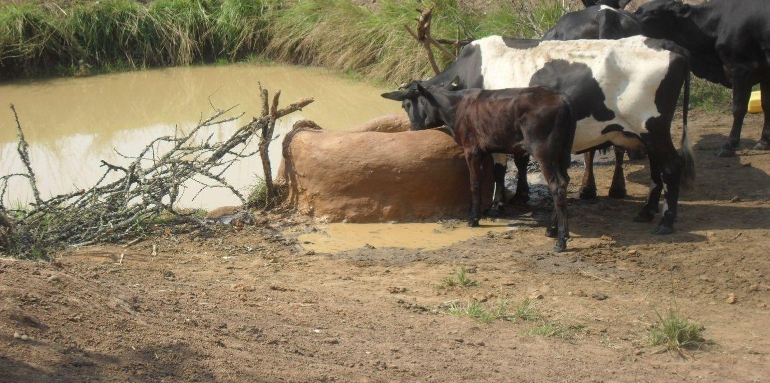
Cattle drinking water from the trough (Allan Bubelwa (Box 38 Kyaka, Missenyi, Tanzania))

Indigenous water collecting pond and livestock watering trough (Tanzania, United Republic of)

elyeshero ne elyato (Haya tribe)

Description

Construction of indigenous water pond and a livestock watering trough along an underground water source.

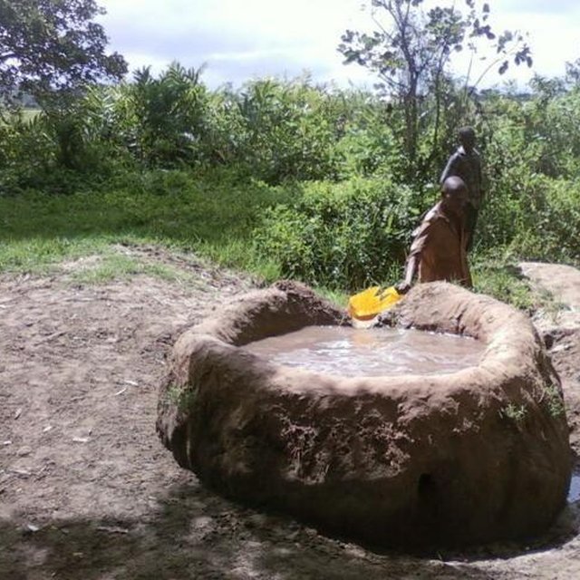
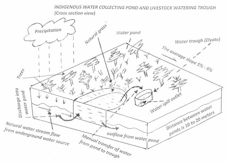
This technology is used during the dry seasons and where ground water level is high and there is natural water stream flowing from underground water source. Water pond is excavated along the naturally flowing water stream and is recharged by natural ground water. The size of the pond will vary depending on the area available, groundwater table, slope and soil characteristic. Groundwater collection ponds described in this technology on average are 4m long, 3m wide and 1m deep of 12m3 (12 000 liter) capacity and the slope is moderate 5% to 8% and soil characteristics is clay loam with deep soil. Water troughs (Elyato by local name) are constructed adjacent to the water pond to allow livestock to access clean drinking water. The number of troughs per pond is usually 1 to 2. Materials used in construction of water trough include clay, red termite mound soil, grass and wooden poles. The number of ponds needed usually depends on the expected number of animals and are arranged at irregular intervals ranging from 10 to 20 meters apart. The average size of a water trough is 0.14 m3 and can cater for 5 cattle at a time. The Pond is stabilized by naturally growing grass on its banks. Common pond stabilizer species are Leodicatiar digitalia and Hyperrhenia rufa. Management of the natural water source is through preventive village/customary by-laws which prohibit tree and grass cutting around the water source. The dominant indicator tree species normally found are Erythrina abysinica, Ficus thorgii and Phoenix recrinata. The animal watering troughs are usually used in the dry period. Before watering the troughs are coated (smeared) with red termite mound soil (normally hand carried by herders) to provide a good taste which is attractive to animals. Water is transferred from the pond to the water trough manually using cans or buckets. Animals drink directly from the troughs. This water from the trough is rich in iron (Fe) from red termite mound soil. The troughs are constructed with outlets used to spill out water immediately after drinking in order to prevent their damage through excessive water saturation.

Purpose of the Technology: This technology is preferred by livestock keepers as it provides for animals to drink clean and mineralized water and for health improvement. User fee payed to land owners also enable them to expand and diversify there income sources.

Establishment / maintenance activities and inputs: Establishment: Land clearing, excavation and shaping of water pond and construction of animal watering trough.
Maintenance: repair of water pond and water trough (de-siltation, grass slashing and gap refilling).
Inputs: labour, implements (machete, spade, hand hoe, sickle), clay, red termite mound soil, wooden poles, buckets, grass and tying rope. Average establishment cost for one pond and its water trough is 41.27 American dollars. Average annual maintenance and recurrent costs (filling and emptying of water trough) for one pond and its water trough stands at 458.76 dollars and labour is a core cost determinant factor.

Natural / human environment: Natural environment: Extensive grazing land. The technology is largely structural (excavation and shaping of water ponds and construction of water troughs) supported by the use of by-laws which prohibit destruction of the protective natural and indicative trees and grasses around. The technology is common in sub-humid climatic zone.
Social economic environment: Level of mechanization is handy tools with subsistence production systems on individual fields.

Location

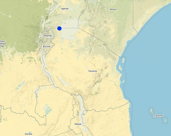
Location: Missenyi District (Minziro), Tanzania, Tanzania, United Republic of

No. of Technology sites analysed:

Geo-reference of selected sites
  • 31.52599, -1.03747

Spread of the Technology: evenly spread over an area (approx. < 0.1 km2 (10 ha))

In a permanently protected area?:

Date of implementation: more than 50 years ago (traditional)

Type of introduction
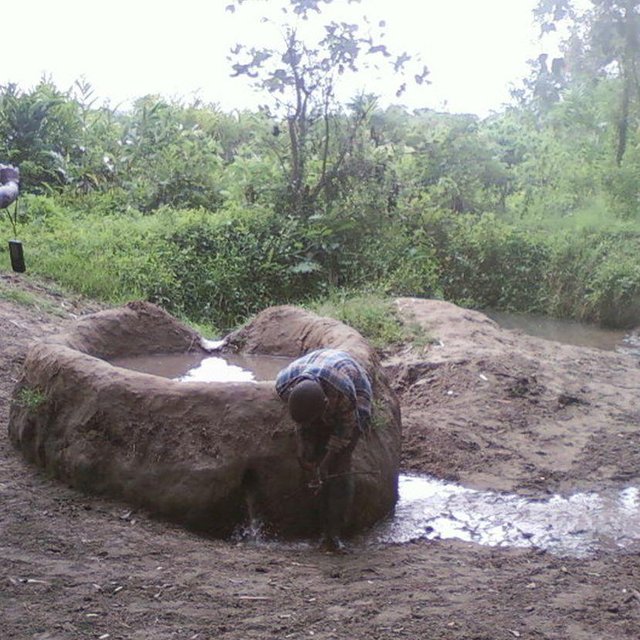
Empting of water trough emediately after animals drink to prevent wetting. (Allan Bubelwa (Box 38 Kyaka, Missenyi, Kagera, Tanzania.))
A livestock keeper transferring water from the water pond to the trough ready for animals to drink. (Allan Bubelwa (Box 38 Kyaka, Missenyi, Tanzania))

Classification of the Technology

Main purpose
  • improve production
  • reduce, prevent, restore land degradation
  • conserve ecosystem
  • protect a watershed/ downstream areas – in combination with other Technologies
  • preserve/ improve biodiversity
  • reduce risk of disasters
  • adapt to climate change/ extremes and its impacts
  • mitigate climate change and its impacts
  • create beneficial economic impact
  • create beneficial social impact
Land use
Land use mixed within the same land unit: Yes - Agro-pastoralism (incl. integrated crop-livestock)

  • CroplandNumber of growing seasons per year: 2
  • Grazing land
    • Semi-nomadic pastoralism
    Animal type: cattle - dairy, goats, sheep
  • Forest/ woodlands
Water supply
  • rainfed
  • mixed rainfed-irrigated
  • full irrigation

Purpose related to land degradation
  • prevent land degradation
  • reduce land degradation
  • restore/ rehabilitate severely degraded land
  • adapt to land degradation
  • not applicable
Degradation addressed
  • physical soil deterioration - Pc: compaction
  • biological degradation - Bc: reduction of vegetation cover
  • water degradation - Hp: decline of surface water quality
SLM group
  • n.a.
SLM measures
  • vegetative measures - V1: Tree and shrub cover, V2: Grasses and perennial herbaceous plants
  • structural measures - S11: Others
  • management measures - M7: Others

Technical drawing

Technical specifications
Water pond and water trough cross section view.
The water pond has an average internal capacity of size of 12m3 (4m length, 3m width and 1m depth).
Water troughs are constructed on the side of the water ponds. The water trough outside height is 0.2 - 0.4m above ground, inner depth is 0.5m, and diameter varies from 0.6 to 1m. It is made of cylindrical walls whose average width is 0.1m.
The average slope of the water catchment is 5% to 8%.

Location: Minziro village, Minziro ward, Missenyi division. Missenyi Dist, Kagera Reg, United Rep of Tanzania

Technical knowledge required for land users: moderate (At least primary school leaver with the basic indigenous technical knowledge.)

Main technical functions: control of dispersed runoff: retain / trap, control of concentrated runoff: retain / trap, water harvesting / increase water supply, improvement of water quality, buffering / filtering water

Secondary technical functions: improvement of ground cover, improvement of surface structure (crusting, sealing), stabilisation of soil (eg by tree roots against land slides), increase / maintain water stored in soil, increase of groundwater level / recharge of groundwater, water spreading, sediment retention / trapping, sediment harvesting, increase of biomass (quantity), control of fires, spatial arrangement and diversification of land use

Dam/ pan/ pond
Vertical interval between structures (m): 0
Spacing between structures (m): 10 to 20
Depth of ditches/pits/dams (m): 1
Width of ditches/pits/dams (m): 3
Length of ditches/pits/dams (m): 4
Height of bunds/banks/others (m): 0.3
Width of bunds/banks/others (m): 0.3
Length of bunds/banks/others (m): 4

Structural measure: water trough
Depth of ditches/pits/dams (m): 0.5
Width of ditches/pits/dams (m): 0.6 to 1
Length of ditches/pits/dams (m): 0.6 to 1
Height of bunds/banks/others (m): 0.2
Width of bunds/banks/others (m): 0.1
Length of bunds/banks/others (m): 0.6

Construction material (earth): mostry used clay soil and red termite mound soil.

Construction material (wood): for water pond and trough stabilization

Slope (which determines the spacing indicated above): 8%

If the original slope has changed as a result of the Technology, the slope today is: 8%

Lateral gradient along the structure: 5%

Specification of dams/ pans/ ponds: Capacity 10.6m3

Catchment area: 4 acresm2

For water harvesting: the ratio between the area where the harvested water is applied and the total area from which water is collected is: 1:4

Vegetation is used for stabilisation of structures.
Author: Allan Bubelwa, Box 38 Kyaka Missenyi

Establishment and maintenance: activities, inputs and costs

Calculation of inputs and costs
  • Costs are calculated:
  • Currency used for cost calculation: Tanzanian shillings
  • Exchange rate (to USD): 1 USD = 1600.0 Tanzanian shillings
  • Average wage cost of hired labour per day: 3.13
Most important factors affecting the costs
Labour is the most determinant factor affecting the costs
Establishment activities
  1. Land preparation for pond excavation (Timing/ frequency: During dry season)
  2. Construction of pond (Timing/ frequency: During dry period)
  3. Construction of water trough (Timing/ frequency: During dry season)
Establishment inputs and costs
Specify input Unit Quantity Costs per Unit (Tanzanian shillings) Total costs per input (Tanzanian shillings) % of costs borne by land users
Labour
Land preparation for pond excavation person/day 1.0 1.25 1.25 100.0
Construction of pond person/day 1.0 21.88 21.88 100.0
Construction of water trough person/day 1.0 3.13 3.13 100.0
Equipment
Tools piece 1.0 3.13 3.13 100.0
Tools piece 3.0 9.38 28.14 100.0
Construction material
Wood pieces 2.0 1.25 2.5 100.0
Earth kg 20.0 1.25 25.0 100.0
Total costs for establishment of the Technology 85.03
Total costs for establishment of the Technology in USD 0.05
Maintenance activities
  1. Desiltation (Timing/ frequency: During dry season)
  2. Wall and bank strengthening and repair (reshaping and grass slashing/gap filling) (Timing/ frequency: During dry season)
  3. Water trough repairing (Timing/ frequency: dry season)
  4. Filling to and emptying water from water trough and collection and application of red termite mound soil. (Timing/ frequency: None)
Maintenance inputs and costs
Specify input Unit Quantity Costs per Unit (Tanzanian shillings) Total costs per input (Tanzanian shillings) % of costs borne by land users
Labour
Desiltation person days 5.0 6.25 31.25 100.0
Wall and bank strengthening and repair (reshaping and grass slashing/gap filling) person days 5.0 6.25 31.25 100.0
Water trough repairing person days 8.0 10.0 80.0 100.0
Filling to and emptying water from water trough and collection and application of red termite mound soil. person days 450.0 1.25 562.5 100.0
Equipment
Tools pieces 2.0 5.0 10.0 100.0
Water can pieces 2.0 1.88 3.76 100.0
Construction material
Wood pieces 6.0 3.75 22.5 100.0
Earth kg 60.0 3.75 225.0 100.0
Total costs for maintenance of the Technology 966.26
Total costs for maintenance of the Technology in USD 0.6

Natural environment

Average annual rainfall
  • < 250 mm
  • 251-500 mm
  • 501-750 mm
  • 751-1,000 mm
  • 1,001-1,500 mm
  • 1,501-2,000 mm
  • 2,001-3,000 mm
  • 3,001-4,000 mm
  • > 4,000 mm
Agro-climatic zone
  • humid
  • sub-humid
  • semi-arid
  • arid
Specifications on climate
Thermal climate class: tropics. all months temperature is above 18

Thermal climate class: subtropics

Thermal climate class: temperate

Thermal climate class: boreal

Thermal climate class: polar/arctic
Slope
  • flat (0-2%)
  • gentle (3-5%)
  • moderate (6-10%)
  • rolling (11-15%)
  • hilly (16-30%)
  • steep (31-60%)
  • very steep (>60%)
Landforms
  • plateau/plains
  • ridges
  • mountain slopes
  • hill slopes
  • footslopes
  • valley floors
Altitude
  • 0-100 m a.s.l.
  • 101-500 m a.s.l.
  • 501-1,000 m a.s.l.
  • 1,001-1,500 m a.s.l.
  • 1,501-2,000 m a.s.l.
  • 2,001-2,500 m a.s.l.
  • 2,501-3,000 m a.s.l.
  • 3,001-4,000 m a.s.l.
  • > 4,000 m a.s.l.
Technology is applied in
  • convex situations
  • concave situations
  • not relevant
Soil depth
  • very shallow (0-20 cm)
  • shallow (21-50 cm)
  • moderately deep (51-80 cm)
  • deep (81-120 cm)
  • very deep (> 120 cm)
Soil texture (topsoil)
  • coarse/ light (sandy)
  • medium (loamy, silty)
  • fine/ heavy (clay)
Soil texture (> 20 cm below surface)
  • coarse/ light (sandy)
  • medium (loamy, silty)
  • fine/ heavy (clay)
Topsoil organic matter content
  • high (>3%)
  • medium (1-3%)
  • low (<1%)
Groundwater table
  • on surface
  • < 5 m
  • 5-50 m
  • > 50 m
Availability of surface water
  • excess
  • good
  • medium
  • poor/ none
Water quality (untreated)
  • good drinking water
  • poor drinking water (treatment required)
  • for agricultural use only (irrigation)
  • unusable
Water quality refers to:
Is salinity a problem?
  • Yes
  • No

Occurrence of flooding
  • Yes
  • No
Species diversity
  • high
  • medium
  • low
Habitat diversity
  • high
  • medium
  • low

Characteristics of land users applying the Technology

Market orientation
  • subsistence (self-supply)
  • mixed (subsistence/ commercial)
  • commercial/ market
Off-farm income
  • less than 10% of all income
  • 10-50% of all income
  • > 50% of all income
Relative level of wealth
  • very poor
  • poor
  • average
  • rich
  • very rich
Level of mechanization
  • manual work
  • animal traction
  • mechanized/ motorized
Sedentary or nomadic
  • Sedentary
  • Semi-nomadic
  • Nomadic
Individuals or groups
  • individual/ household
  • groups/ community
  • cooperative
  • employee (company, government)
Gender
  • women
  • men
Age
  • children
  • youth
  • middle-aged
  • elderly
Area used per household
  • < 0.5 ha
  • 0.5-1 ha
  • 1-2 ha
  • 2-5 ha
  • 5-15 ha
  • 15-50 ha
  • 50-100 ha
  • 100-500 ha
  • 500-1,000 ha
  • 1,000-10,000 ha
  • > 10,000 ha
Scale
  • small-scale
  • medium-scale
  • large-scale
Land ownership
  • state
  • company
  • communal/ village
  • group
  • individual, not titled
  • individual, titled
Land use rights
  • open access (unorganized)
  • communal (organized)
  • leased
  • individual
Water use rights
  • open access (unorganized)
  • communal (organized)
  • leased
  • individual
Access to services and infrastructure
health

poor
x
good
education

poor
x
good
technical assistance

poor
x
good
employment (e.g. off-farm)

poor
x
good
markets

poor
x
good
roads and transport

poor
x
good
drinking water and sanitation

poor
x
good

Impacts

Socio-economic impacts
animal production
decreased
x
increased

product diversity
decreased
x
increased

energy generation (e.g. hydro, bio)
decreased
x
increased

drinking water availability
decreased
x
increased

diversity of income sources
decreased
x
increased

economic disparities
increased
x
decreased

Socio-cultural impacts
community institutions
weakened
x
strengthened

national institutions
weakened
x
strengthened

SLM/ land degradation knowledge
reduced
x
improved

Ecological impacts
water quantity
decreased
x
increased

water quality
decreased
x
increased

harvesting/ collection of water (runoff, dew, snow, etc)
reduced
x
improved

surface runoff
increased
x
decreased

groundwater table/ aquifer
lowered
x
recharge

evaporation
increased
x
decreased

soil moisture
decreased
x
increased

nutrient cycling/ recharge
decreased
x
increased

biomass/ above ground C
decreased
x
increased

habitat diversity
decreased
x
increased

pest/ disease control
decreased
x
increased

emission of carbon and greenhouse gases
increased
x
decreased

fire risk
increased
x
decreased

wind velocity
increased
x
decreased

Off-site impacts
reliable and stable stream flows in dry season (incl. low flows)
reduced
x
increased

downstream flooding (undesired)
increased
x
reduced

buffering/ filtering capacity (by soil, vegetation, wetlands)
reduced
x
improved

damage on neighbours' fields
increased
x
reduced

Cost-benefit analysis

Benefits compared with establishment costs
Short-term returns
very negative
x
very positive

Long-term returns
very negative
x
very positive

Benefits compared with maintenance costs
Short-term returns
very negative
x
very positive

Long-term returns
very negative
x
very positive

The technology requires low establishment and maintenance cost and benefit surpass the costs.

Climate change

Gradual climate change
annual temperature increase

not well at all
x
very well
Climate-related extremes (disasters)
local rainstorm

not well at all
x
very well
local windstorm

not well at all
x
very well
drought

not well at all
x
very well
general (river) flood

not well at all
x
very well
Other climate-related consequences
reduced growing period

not well at all
very well
Answer: not known

Adoption and adaptation

Percentage of land users in the area who have adopted the Technology
  • single cases/ experimental
  • 1-10%
  • 11-50%
  • > 50%
Of all those who have adopted the Technology, how many have done so without receiving material incentives?
  • 0-10%
  • 11-50%
  • 51-90%
  • 91-100%
Has the Technology been modified recently to adapt to changing conditions?
  • Yes
  • No
To which changing conditions?
  • climatic change/ extremes
  • changing markets
  • labour availability (e.g. due to migration)

Conclusions and lessons learnt

Strengths: land user's view
  • Income generation due to water use fee.

    How can they be sustained / enhanced? improve service to water users. .
Strengths: compiler’s or other key resource person’s view
  • Reduce conflict between livestock keepers and domestic water users.

    How can they be sustained / enhanced? Bylaws reinforcement, Area enclosure and Demarcation
  • Improve accessibility of water to animals (improved animal water intake)

    How can they be sustained / enhanced? sensitization on regular maintenance.
Weaknesses/ disadvantages/ risks: land user's viewhow to overcome
  • Not durable and requires frequent and regular maintenance Sensitize on regular maintenance.
Weaknesses/ disadvantages/ risks: compiler’s or other key resource person’s viewhow to overcome
  • not durable Sensitize on regular maintenance.
  • high labor demand to fill the troughs Use simple leverage pump

References

Compiler
  • ALLAN BUBELWA
Editors
Reviewer
  • Donia Mühlematter
  • Fabian Ottiger
  • Alexandra Gavilano
Date of documentation: April 23, 2013
Last update: Aug. 6, 2019
Resource persons
Full description in the WOCAT database
Linked SLM data
Documentation was faciliated by
Institution Project
Key references
  • Kagera TAMP project website: http://www.fao.org/nr/kagera/en/
This work is licensed under Creative Commons Attribution-NonCommercial-ShareaAlike 4.0 International