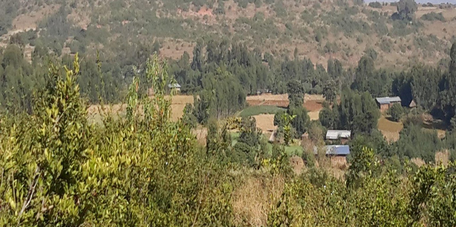
Area closures at the upstream of Debre Yacob watershed (Gizaw Desta (WLRC))

Area closure on degraded lands (Ethiopia)

Yetrakot Meret mekelel (Amharic)

Description

Area closure on degraded lands is a land management practice used to rehabilitate and conserve the natural resource bases, and enhance its natural regeneration and restoring capacity and productive functions by excluding animal and human interferences through community consultation and collective actions.

Area closure is a land management practice that helps to rehabilitate degraded lands, restore the biophysical conditions like soil, vegetation and hydrology by avoiding the interference of animals and human. Because of over grazing and erosion impact, areas delineated for closure are usually degraded shrub or pasture lands that served for grazing. First of all, implementing area closure requires continuous dialogue and discussion with community to reach consensus to close. The community wants to make sure they have benefited from the technology as the land was serving for grazing. They should take the responsibility and create sense of ownership to implement conservation measures, protect and maintain closure areas, and regulate utilization of benefits gained out of it. Questions raised from the community must be discussed thoroughly ahead of the implementation. What part of the degraded land? For what purpose the area is closed? Who are the users? Who are responsible to protect and manage the developed resourcess? How is the benefit sharing among identified users? Commonly, the shared benefits from area closures are hay for livestock through cut-and-carry system, timbers from plantations, and honey production.
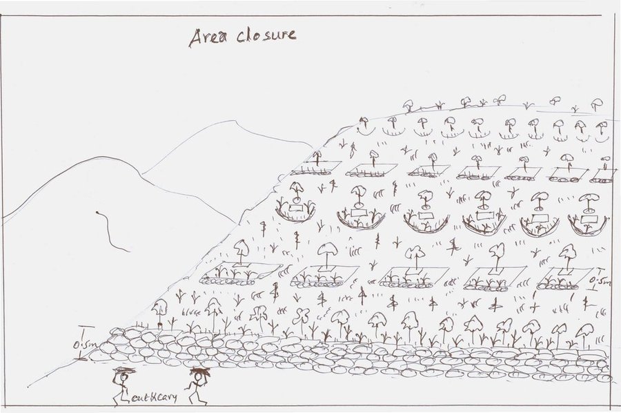
Depending on the soil, rainfall and slope conditions different structural and vegetative measures are integrated to enhance the fast regeneration of plant species, restore the soil and increase water availability. It includes enrichment used to rehabilitate and increase the vegetation cover, vegetative and structural measures to retain the soil and water on its place. Structures such as hillside terrace often integrated with grass or shrub hedgerows is used to control soil erosion. In-situ water harvesting structures such as trenches or half moon or eye brow are used to harvest and infiltrate rain or runoff water to increase regeneration and survival of planted trees. Trees and/or shrub species that have high rehabilitation and multipurpose values are used as enrichment plantations. Closed areas need collective action to protect, maintain and manage the common resources. Collective user rights have to be entitled to bring equity on resource sharing and minimize social conflicts.

The purposes of area closure are: 1) rehabilitate degraded lands, 2) protect and restore the natural resource base, and 3) change into productive land and enhance economic and environmental functions of rehabilitated lands.

Implementation of area closure begins with the selection and demarcation of area through genuine participation of land users. After identifying the area to be closed, at establishment stage construction of ditches and terraces is made using stones combined with grasses or shrubs of multipurpose value such as Vetiver grass, Dinsho grass, Bana grass, susbania, etc. Depending on site conditions, enrichment tree species which have rehabilitation and soil restoration purposes are planted in the form of wood lot or scattered tree plantation. Among the common species, A. albida, A. saligna, A. decurrense, Gravilia robusta, etc. are used to rehabilitate and serve as fuel wood and timber. In moisture stress areas structures like trench, level bunds, and half moon should be constructed to increase survival rate of planted tree/shrub species whereas in areas having sufficient moisture these structures, depending on the landforms and soil drainage conditions, help to increase infiltration and recharging of ground water in downstream areas. Therefore, site selection and demarcation, construction of soil conservation and moisture conservation structures, and seedling management and plantation of multipurpose trees, shrubs and grasses are the activities accomplished at establishment stage of area closure. The required inputs are stones, seeds/seedlings, grass cuttings/splits, hand tools, and collective labor. For recurrent maintenance activities, seedlings and cuttings for re-plantation purpose or replace dead seedlings, stones to repair damage stone terraces and moisture conservation structures. Harvesting and transporting of area closure products such as grass and timber become a recurrent activity. Person days per hectare per year required for plantation (preparation of holes and planting) is 11.5, for harvesting and transporting harvested grass is 30, and for terrace construction is 26.5.

Area closure management is commonly practiced on degraded hills where soil is highly depleted, its water holding capacity is low, and vegetation is denuded. Usually degraded lands are used to serve for communal grazing system. The degree of land degradation becomes severe where there are high livestock and human population pressure. Management of closure area and the benefit sharing has to be regulated using agreed bylaws.

The living condition depends on subsistence crop-livestock mixed farming. On average households have 5-6 family size. Crop production is meant for home consumption with small surplus for local market. The services related to water supply, energy supply, and infrastructure are low. Besides it is an asset, animals often used to cope shocks during drought periods.

Location

Location: Mecha / Yilmana Densa / Bahir Dar Zuria, Amhara National Regional State, Ethiopia

No. of Technology sites analysed:

Geo-reference of selected sites
  • n.a.

Spread of the Technology: evenly spread over an area (approx. 1-10 km2)

In a permanently protected area?:

Date of implementation: less than 10 years ago (recently)

Type of introduction
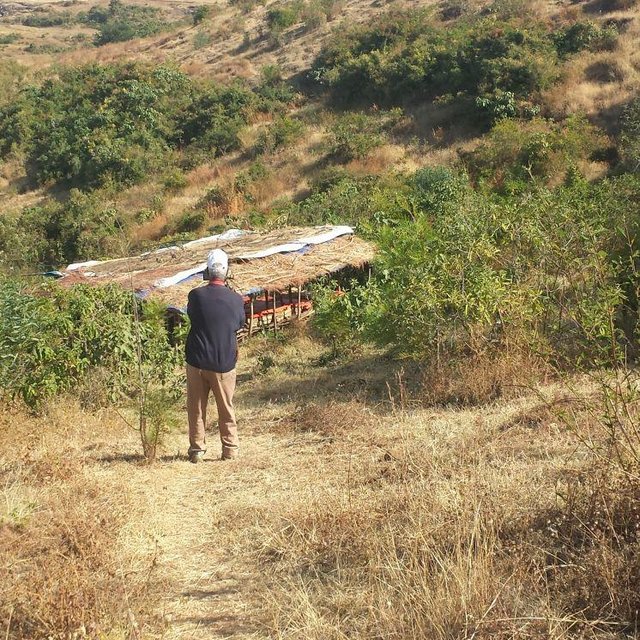
Area closure integrated with apiculture for youths' income generation (Gizaw Desta (WLRC))

Classification of the Technology

Main purpose
  • improve production
  • reduce, prevent, restore land degradation
  • conserve ecosystem
  • protect a watershed/ downstream areas – in combination with other Technologies
  • preserve/ improve biodiversity
  • reduce risk of disasters
  • adapt to climate change/ extremes and its impacts
  • mitigate climate change and its impacts
  • create beneficial economic impact
  • create beneficial social impact
Land use
Land use mixed within the same land unit: Yes - Agro-pastoralism (incl. integrated crop-livestock)

  • Cropland
    • Perennial (non-woody) cropping
    • Tree and shrub cropping
    Number of growing seasons per year: 1
  • Grazing land
    • Semi-nomadic pastoralism
    • Cut-and-carry/ zero grazing
  • Forest/ woodlandsProducts and services: Timber, Fuelwood, Grazing/ browsing

Water supply
  • rainfed
  • mixed rainfed-irrigated
  • full irrigation

Purpose related to land degradation
  • prevent land degradation
  • reduce land degradation
  • restore/ rehabilitate severely degraded land
  • adapt to land degradation
  • not applicable
Degradation addressed
  • soil erosion by water - Wt: loss of topsoil/ surface erosion, Wo: offsite degradation effects
  • chemical soil deterioration - Cn: fertility decline and reduced organic matter content (not caused by erosion)
  • biological degradation - Bc: reduction of vegetation cover, Bh: loss of habitats
SLM group
  • area closure (stop use, support restoration)
SLM measures
  • vegetative measures - V1: Tree and shrub cover, V2: Grasses and perennial herbaceous plants
  • structural measures - S2: Bunds, banks, S3: Graded ditches, channels, waterways, S4: Level ditches, pits
  • management measures - M1: Change of land use type, M2: Change of management/ intensity level

Technical drawing

Technical specifications
Integrated practices of area closure including hillside bunds, trenches, micro-basins, and trees/shrubs
Location: Debre Yacob Learning Watershed. Mecha/West Gojam/Amhara
Date: 2014-5-23

Technical knowledge required for field staff / advisors: moderate (Field staffs need to acquire technical knowledge on how to integrate different practices and strategies depending on the conditions and degree of degradation.)
Technical knowledge required for land users: low (Land users require low knowledge. Once they implement practices in the closure area, they are able to coordinate and respect the bylaws and equitable distribution of benefits.)

Main technical functions: control of raindrop splash, control of dispersed runoff: retain / trap, control of concentrated runoff: impede / retard, improvement of ground cover, increase of biomass (quantity)
Secondary technical functions: control of concentrated runoff: drain / divert, improvement of topsoil structure (compaction), increase in organic matter, increase / maintain water stored in soil

Aligned: -contour
Vegetative material: T : trees / shrubs, G : grass
Number of plants per (ha): 4000-6000
Spacing between rows / strips / blocks (m): 5
Vertical interval within rows / strips / blocks (m): 0.5-1.0
Width within rows / strips / blocks (m): 0.5

Scattered / dispersed
Vegetative material: T : trees / shrubs
Number of plants per (ha): 160

In blocks
Vegetative material: T : trees / shrubs
Spacing between rows / strips / blocks (m): 2
Vertical interval within rows / strips / blocks (m): 2

Trees/ shrubs species: Gravilia, Susbania, Acacia decurrence
Grass species: Napier
Slope (which determines the spacing indicated above): 20-30%
Gradient along the rows / strips: 0.5%

Diversion ditch/ drainage
Depth of ditches/pits/dams (m): 0.3-0.7
Width of ditches/pits/dams (m): 1.2-2.8
Length of ditches/pits/dams (m): 100-250

Waterway
Depth of ditches/pits/dams (m): 0.3
Width of ditches/pits/dams (m): 1.5-2.0

Bund/ bank: level
Spacing between structures (m): 5
Height of bunds/banks/others (m): 0.5
Width of bunds/banks/others (m): 1-1.5

Slope (which determines the spacing indicated above): 15-35%
Vegetation is used for stabilisation of structures.

Change of land use type: Initially, the land is highly degraded and waste land. After an increase in vegetation cover and biomass, its use is thus changed from waste/shrub land/open grazing to cut-and-carry grazing system
Change of land use practices / intensity level: The land use management is changed from open access /communal grazing or shrub land to regulated or organized form of land use management
Author: Bekure Melese, WLRC

Establishment and maintenance: activities, inputs and costs

Calculation of inputs and costs
  • Costs are calculated:
  • Currency used for cost calculation: ETB
  • Exchange rate (to USD): 1 USD = 20.0 ETB
  • Average wage cost of hired labour per day: 2.50
Most important factors affecting the costs
The costs of area closure affected by the labour availability, regeneration capacity of trees on the degraded lands
Establishment activities
  1. Preparation of seedlings (Timing/ frequency: March-May)
  2. Transporting seedlings (Timing/ frequency: July)
  3. Transporting grass splits (Timing/ frequency: July)
  4. Sowing seeds on bunds (Timing/ frequency: July)
  5. Planting of trees and shrubs (Timing/ frequency: July)
  6. Planting of grass splits or cuttings (Timing/ frequency: July)
  7. Construction of bunds or terraces (Timing/ frequency: February-April)
  8. Construction of cutoff drains and ditches (Timing/ frequency: Fegruary-April)
  9. Construction of waterways (Timing/ frequency: February-April)
  10. Surveying or layout of structures (Timing/ frequency: January-March)
  11. Consultation of the community (Timing/ frequency: None)
  12. Establish bylaws to control free grazing (Timing/ frequency: None)
  13. Establish user groups and arrange equitable benefit sharing (Timing/ frequency: None)
Establishment inputs and costs
Specify input Unit Quantity Costs per Unit (ETB) Total costs per input (ETB) % of costs borne by land users
Labour
labour ha 1.0 1766.0 1766.0 80.0
Equipment
tools ha 1.0 300.6 300.6 50.0
Plant material
seedlings ha 1.0 405.6 405.6 100.0
seeds ha 1.0 20.0 20.0 100.0
Construction material
stone ha 1.0 1300.0 1300.0 100.0
Total costs for establishment of the Technology 3'792.2
Total costs for establishment of the Technology in USD 189.61
Maintenance activities
  1. Preparation of seedlings (Timing/ frequency: March-May)
  2. Seedling transportation (Timing/ frequency: July)
  3. Grass split transportation (Timing/ frequency: July)
  4. Planting seedlings (Timing/ frequency: July)
  5. Planting grass splits (Timing/ frequency: July)
  6. Maintenance of bunds / cutoff drains (Timing/ frequency: None)
  7. Enforcing bylaws (Timing/ frequency: Throught the year)
  8. Benefit sharing among user groups (Timing/ frequency: Throughout the year)
Maintenance inputs and costs
Specify input Unit Quantity Costs per Unit (ETB) Total costs per input (ETB) % of costs borne by land users
Labour
labour ha 1.0 624.0 624.0 29.0
Plant material
seedlings ha 1.0 250.0 250.0 100.0
Total costs for maintenance of the Technology 874.0
Total costs for maintenance of the Technology in USD 43.7

Natural environment

Average annual rainfall
  • < 250 mm
  • 251-500 mm
  • 501-750 mm
  • 751-1,000 mm
  • 1,001-1,500 mm
  • 1,501-2,000 mm
  • 2,001-3,000 mm
  • 3,001-4,000 mm
  • > 4,000 mm
Agro-climatic zone
  • humid
  • sub-humid
  • semi-arid
  • arid
Specifications on climate
Thermal climate class: subtropics
Slope
  • flat (0-2%)
  • gentle (3-5%)
  • moderate (6-10%)
  • rolling (11-15%)
  • hilly (16-30%)
  • steep (31-60%)
  • very steep (>60%)
Landforms
  • plateau/plains
  • ridges
  • mountain slopes
  • hill slopes
  • footslopes
  • valley floors
Altitude
  • 0-100 m a.s.l.
  • 101-500 m a.s.l.
  • 501-1,000 m a.s.l.
  • 1,001-1,500 m a.s.l.
  • 1,501-2,000 m a.s.l.
  • 2,001-2,500 m a.s.l.
  • 2,501-3,000 m a.s.l.
  • 3,001-4,000 m a.s.l.
  • > 4,000 m a.s.l.
Technology is applied in
  • convex situations
  • concave situations
  • not relevant
Soil depth
  • very shallow (0-20 cm)
  • shallow (21-50 cm)
  • moderately deep (51-80 cm)
  • deep (81-120 cm)
  • very deep (> 120 cm)
Soil texture (topsoil)
  • coarse/ light (sandy)
  • medium (loamy, silty)
  • fine/ heavy (clay)
Soil texture (> 20 cm below surface)
  • coarse/ light (sandy)
  • medium (loamy, silty)
  • fine/ heavy (clay)
Topsoil organic matter content
  • high (>3%)
  • medium (1-3%)
  • low (<1%)
Groundwater table
  • on surface
  • < 5 m
  • 5-50 m
  • > 50 m
Availability of surface water
  • excess
  • good
  • medium
  • poor/ none
Water quality (untreated)
  • good drinking water
  • poor drinking water (treatment required)
  • for agricultural use only (irrigation)
  • unusable
Water quality refers to:
Is salinity a problem?
  • Yes
  • No

Occurrence of flooding
  • Yes
  • No
Species diversity
  • high
  • medium
  • low
Habitat diversity
  • high
  • medium
  • low

Characteristics of land users applying the Technology

Market orientation
  • subsistence (self-supply)
  • mixed (subsistence/ commercial)
  • commercial/ market
Off-farm income
  • less than 10% of all income
  • 10-50% of all income
  • > 50% of all income
Relative level of wealth
  • very poor
  • poor
  • average
  • rich
  • very rich
Level of mechanization
  • manual work
  • animal traction
  • mechanized/ motorized
Sedentary or nomadic
  • Sedentary
  • Semi-nomadic
  • Nomadic
Individuals or groups
  • individual/ household
  • groups/ community
  • cooperative
  • employee (company, government)
Gender
  • women
  • men
Age
  • children
  • youth
  • middle-aged
  • elderly
Area used per household
  • < 0.5 ha
  • 0.5-1 ha
  • 1-2 ha
  • 2-5 ha
  • 5-15 ha
  • 15-50 ha
  • 50-100 ha
  • 100-500 ha
  • 500-1,000 ha
  • 1,000-10,000 ha
  • > 10,000 ha
Scale
  • small-scale
  • medium-scale
  • large-scale
Land ownership
  • state
  • company
  • communal/ village
  • group
  • individual, not titled
  • individual, titled
Land use rights
  • open access (unorganized)
  • communal (organized)
  • leased
  • individual
Water use rights
  • open access (unorganized)
  • communal (organized)
  • leased
  • individual
Access to services and infrastructure
health

poor
good
education

poor
good
technical assistance

poor
good
employment (e.g. off-farm)

poor
good
markets

poor
good
energy

poor
good
roads and transport

poor
good
drinking water and sanitation

poor
good
financial services

poor
good

Impacts

Socio-economic impacts
fodder production
decreased
increased


Mainly serve for grass harvest

animal production
decreased
increased


Cut and carry improve the production

production area (new land under cultivation/ use)
decreased
increased


By improving the land use management, production area for pasture increased

diversity of income sources
decreased
increased


People try to diverse apiculture production in closed areas

workload
increased
decreased


Labor requirement to harvest and transport fodder and pasture increase

Socio-cultural impacts
community institutions
weakened
strengthened


Establishment of user groups and watershed users association

SLM/ land degradation knowledge
reduced
improved


Increase the level of awareness that area closure can shortly reverse land degradation

conflict mitigation
worsened
improved


Reduce conflict arise due to pasture shortage

situation of socially and economically disadvantaged groups (gender, age, status, ehtnicity etc.)
worsened
improved


Some rural unemployed youths get employed in apiculture production and fruit production

contribution to human well-being
decreased
increased


The livestock production is moderately improved due to increase in biomass/ pasture harvest

Ecological impacts
water quantity
decreased
increased

surface runoff
increased
decreased

groundwater table/ aquifer
lowered
recharge

soil moisture
decreased
increased

soil cover
reduced
improved

soil loss
increased
decreased

biomass/ above ground C
decreased
increased

plant diversity
decreased
increased

habitat diversity
decreased
increased

fire risk
increased
decreased

Off-site impacts
reliable and stable stream flows in dry season (incl. low flows)
reduced
increased

Quantity before SLM: End of Nov
Quantity after SLM: Mar-April
Because of high vegetation cover, the recharrging capacity improved resulting in prolonging the stream flow/baseflow

downstream flooding (undesired)
increased
reduced

downstream siltation
increased
decreased

Cost-benefit analysis

Benefits compared with establishment costs
Short-term returns
very negative
very positive

Long-term returns
very negative
very positive

Benefits compared with maintenance costs
Short-term returns
very negative
very positive

Long-term returns
very negative
very positive

Short term economic benefits can be attained by harvesting forage biomass for livestock while in the long term downstream agricultural productivity can be improved as they witnessed the change in stream flows to be used for irrigation. This is very much pronounced in Aba Gerima watershed where farmers in the downstream get to access more water.

Climate change

Climate-related extremes (disasters)
local rainstorm

not well at all
very well
drought

not well at all
very well
general (river) flood

not well at all
very well

Adoption and adaptation

Percentage of land users in the area who have adopted the Technology
  • single cases/ experimental
  • 1-10%
  • 11-50%
  • > 50%
Of all those who have adopted the Technology, how many have done so without receiving material incentives?
  • 0-10%
  • 11-50%
  • 51-90%
  • 91-100%
Has the Technology been modified recently to adapt to changing conditions?
  • Yes
  • No
To which changing conditions?
  • climatic change/ extremes
  • changing markets
  • labour availability (e.g. due to migration)

Conclusions and lessons learnt

Strengths: land user's view
  • Increase in vegetation cover and biomass production for livestock feed
  • Increase the duration and flow of streams
  • Decrease erosion
  • Decrease transmission of animal disease often a problem during open grazing system
Strengths: compiler’s or other key resource person’s view
  • Increase the fodder and grass biomass production for livestock feed
  • Increase the regeneration of lost plant diversities
  • Create alternative livelihood options (off farm activities like honey production, timber, tree or fodder seed production)
  • Enhance the micro-climatic conditions and on-site vegetation cover, organic matter, and soil water holding capacity. In addition it improves off-site surface and subsurface water flows
Weaknesses/ disadvantages/ risks: land user's viewhow to overcome
  • Land users' perceived that implementation of the technology decreases open access to communal pasture lands to maximize their benefit Awareness creation activities has to be provided
  • Shortage of labor to harvest and transport forages to feed animals Cost effective technologies to prepare feed, handle and transport forage has to be introduced and adopted. It can be overcomed by organizing service provider groups.
  • The amount of pasture/fodder produced and shared among users is much less than the feed requirement of all animals hold by a household Introduce fodder species producing high biomass and high quality fodder; decrease livestock number per household.
Weaknesses/ disadvantages/ risks: compiler’s or other key resource person’s viewhow to overcome
  • Labor constraint for cut-and -carry for stall feeding It can be sustained through organizing service providers groups
  • Stall feeding restricted the cross breeding of animals in the village easily accessible during open grazing Artificial insemination and bull services and synchronization breeding system has to be promoted

References

Compiler
  • Gizaw Desta Gessesse
Editors
Reviewer
  • Deborah Niggli
  • Alexandra Gavilano
Date of documentation: May 9, 2014
Last update: Sept. 9, 2019
Resource persons
Full description in the WOCAT database
Linked SLM data
Documentation was faciliated by
Institution Project
Key references
  • Sustaining the win-win benefits of improved grazing land management in EthiopiaPost written by Wolde Mekuria, WLE. March 30, 2015: WLE post
  • http://www.bioone.org/doi/pdf/10.1659/0276-4741(2005)025%5B0044%3ATROCIC%5D2.0.CO%3B2:
  • Vegetation Improvement in Communal Closed Areas in Tigray, Ethiopia.Sarah Tewolde-Berhan 1,4, Ralph Mitlöhner 2, Bart Muys3 , and Mitiku Haile 4:
  • Natural Regeneration Practice in Degraded High Lands of Ethiopia Through Area Enclosure Wondie Mebrat, Department of Biology, Adigrat University, Adigrat, Tigray, Ethiopia, 2015:
  • Area Closure: Rehabilitation of Degraded Lands and Grasslands and its Multiple Benefits. WLRC Brief No. 2. June 2015: www.wlrc-eth.org
This work is licensed under Creative Commons Attribution-NonCommercial-ShareaAlike 4.0 International