An integrated gully rehabilitation and management techniques (Gizaw Desta (WLRC))

Gully erosion management (Ethiopia)

Borebore lemat (Amharic)

Description

Gully erosion management is the application of combination of practices to control excess or concentrated runoff generation in the gully upstream catchment area, divert excess runoff upstream of gully heads and control further development of gully using appropriate structural and vegetative measures in the head, bed and sides of the gully and eventually convert into productive land through the consultation and involvement of local community.

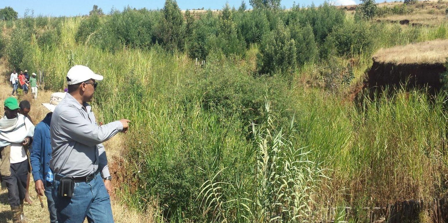
Gully erosion occurs on cultivated and grazing/pasture lands. Gully erosion management is a practice aimed to rehabilitate and protect further development of gullies and change into productive land. It involves both runoff management and erosion control activities. Gully management and treatment is different at upstream catchment area, gully head and gully section. Proper land management practices and slope treatment measures such as terraces, infiltration ditches and grass or shrub hedgerows are taking place on upstream catchment of the gully in order to reduce the rate of surface runoff. The excess runoff above the gully head is safely drained using cutoff drains into natural or properly vegetated waterways in order to reduce the surface water entering into the gully and protect the constructed physical and biological measures being washed away. Before treating gully sections, for the purpose of stability of structures and quick healing, the gully should be reshaped and planted with grass sod. Gully wall reshaping is cutting off steep slopes of active gully flanks in to gentle slope of minimum at 45% slope, up to two-third of the total depth of the gully and constructing small trenches along contours for re-vegetating slanted part of the gully walls and beds. If the gully is wide and has meandering nature with huge accumulation of runoff flowing down, it requires constructing of retaining walls, to protect displaced (not yet stabilized) soils and soil materials and the sidewalls of the reshaped gully. Stabilization of gully sections involves the use of structural and vegetative measures in the head, floor and side of the gully. The construction of physical structures inside the gully section is followed by establishment of biological measures.

Purposes of gully erosion management are: 1) rehabilitate the land damaged due to gully erosion, 2) prevent further expansion and development of gully erosion, and 3) convert the land lost by gully erosion to productive land.

Gully erosion management begins with assessment and mapping of gully erosion that helps to have an overview of erosion, to document extent of damage, to identify the nature and causes of gully formation, and gives relevant information to design appropriate measures. At establishment stage, gully management requires: catchment treatment using different land treatment measures; runoff diversion by cutoff drain; and stabilization of gully sections by physical structures and vegetative measures. Stones for the construction of terraces, cutoff drains and waterways are required. Depending on the nature of gully and available material for construction, either stones, sand bags, brush woods, bamboo mat, gabion or concrete (sand, gravel and cement) are needed for constructing check-dams in a gully section. Different tree/shrub seedlings, grass cuttings, and seedlings of fruit trees are required to reinforce and stabilize the gully sections. The respective labor requirement for stone collection, construction of retaining wall, and gully reshaping is 0.5m3/person day, 5m/person day, and 1m3/person day. Approximately 0.25, 0.50, 0.50, 0.50 , and 1.0 m3/person day is required to construct gabion, loose stone, arc weir, sand bag, and bamboo mat check-dams respectively. About 3.0 m/person day is needed to construct brushwood check dams. The treated gullies should be checked regularly. The maintenance requirement is closely monitored and immediate repair is essential to avoid further damage and eventual collapse of structures. The inputs important for maintenance include stones or other materials for check dams, seedlings to replant areas covered with non-survived seedlings.

Gully erosion is prevalent in areas where excess runoff occurs in high rainfall areas associated with moderate to high erodible soils. It occurs in range of wet highland to moist Kolla areas where annual rainfall exceeds 900mm. Its occurrence is more frequent in heavy clay soils (Vertisols) characterized by low infiltration and in clay soils (like Nitosols) characterized by low organic matter. Often, gully formation occurs on overgrazed pasture lands and inappropriately managed crop lands. Gully erosion control requires mobilization of high input or materials and labor. Larger gullies need to be rehabilitated and treated through community labor mobilization. Subsequent maintenance activities, monitoring and benefit sharing should be made by the user groups who are entitled to utilize the benefits.

The living condition depends on subsistence crop-livestock mixed farming. On average households have 5-6 family size. Crop production is meant for home consumption with small surplus for local market. The services related to water supply, energy supply, and infrastructure are low. Besides it is an asset, animals often used to cope shocks during drought periods.

Location

Location: Dembecha/Mecha/Yilmana Densa, Amhara National Regional State (ANRS), Ethiopia

No. of Technology sites analysed:

Geo-reference of selected sites
  • n.a.

Spread of the Technology: evenly spread over an area (approx. 10-100 km2)

In a permanently protected area?:

Date of implementation: less than 10 years ago (recently)

Type of introduction
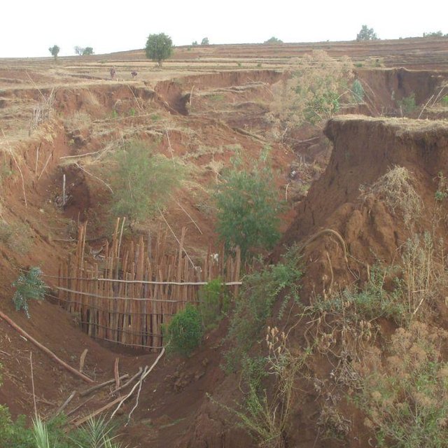
An integrated gully rehabilitation and management techniques (Bekure Melese (WLRC))

Classification of the Technology

Main purpose
  • improve production
  • reduce, prevent, restore land degradation
  • conserve ecosystem
  • protect a watershed/ downstream areas – in combination with other Technologies
  • preserve/ improve biodiversity
  • reduce risk of disasters
  • adapt to climate change/ extremes and its impacts
  • mitigate climate change and its impacts
  • create beneficial economic impact
  • create beneficial social impact
Land use

  • Cropland
    • Annual cropping
    • Perennial (non-woody) cropping
    Number of growing seasons per year: 1
  • Grazing land
    • Semi-nomadic pastoralism
    • Cut-and-carry/ zero grazing
    • free grazing
  • Forest/ woodlandsProducts and services: Timber, Fuelwood

Water supply
  • rainfed
  • mixed rainfed-irrigated
  • full irrigation

Purpose related to land degradation
  • prevent land degradation
  • reduce land degradation
  • restore/ rehabilitate severely degraded land
  • adapt to land degradation
  • not applicable
Degradation addressed
  • soil erosion by water - Wg: gully erosion/ gullying, Wo: offsite degradation effects
  • biological degradation - Bc: reduction of vegetation cover
SLM group
  • area closure (stop use, support restoration)
SLM measures
  • vegetative measures - V1: Tree and shrub cover, V2: Grasses and perennial herbaceous plants
  • structural measures - S2: Bunds, banks, S3: Graded ditches, channels, waterways, S4: Level ditches, pits, S6: Walls, barriers, palisades, fences, S11: Others

Technical drawing

Technical specifications

Establishment and maintenance: activities, inputs and costs

Calculation of inputs and costs
  • Costs are calculated:
  • Currency used for cost calculation: ETB
  • Exchange rate (to USD): 1 USD = 20.0 ETB
  • Average wage cost of hired labour per day: 2.50
Most important factors affecting the costs
The costs for gully erosion management is dependent upon labor, material and transport costs, workability of the soil and maintenance costs.
Establishment activities
  1. Seedling preparation (Timing/ frequency: January-June)
  2. Seedling Transportation (Timing/ frequency: June-July)
  3. Grass split transportation (Timing/ frequency: June -July)
  4. Plantation of biological measures inside the gully (Timing/ frequency: July)
  5. Surveying (Timing/ frequency: Dry season)
  6. Reshaping of gully (Timing/ frequency: Dry season)
  7. Construction of cutoff drains (Timing/ frequency: Dry season)
  8. Construction of waterways (Timing/ frequency: Dry season)
  9. Construction of stone check dams (Timing/ frequency: Dry season)
Establishment inputs and costs
Specify input Unit Quantity Costs per Unit (ETB) Total costs per input (ETB) % of costs borne by land users
Labour
labour ha 1.0 8319.0 8319.0 99.0
Equipment
animal traction ha 1.0 9.0 9.0 100.0
tools ha 1.0 901.8 901.8 50.0
Plant material
grass ha 1.0 20.0 20.0
seeds ha 1.0 24.0 24.0
seedlings ha 1.0 63.45 63.45
Fertilizers and biocides
compost/manure ha 1.0 15.86 15.86
Construction material
stone ha 1.0 1405.0 1405.0 91.0
wood ha 1.0 27.6 27.6
earth ha 1.0 91.2 91.2
Total costs for establishment of the Technology 10'876.91
Total costs for establishment of the Technology in USD 543.85
Maintenance activities
  1. Seedling preparation (Timing/ frequency: January-June)
  2. Seedling and grass split transportation (Timing/ frequency: July)
  3. Replanting seedlings and grass splits (Timing/ frequency: July)
  4. Maintenance of cutoff drains/waterways (Timing/ frequency: Dry season (Jan-Apr))
  5. Maintenance of check dams (Timing/ frequency: Dry season (Jan-Apr))
Maintenance inputs and costs
Specify input Unit Quantity Costs per Unit (ETB) Total costs per input (ETB) % of costs borne by land users
Labour
labour ha 1.0 902.0 902.0 67.0
Equipment
animal traction ha 1.0 4.5 4.5
Plant material
grass ha 1.0 10.3 10.3
seedlings ha 1.0 33.0 33.0
Fertilizers and biocides
compost/manure ha 1.0 8.5 8.5
Construction material
stone ha 1.0 50.0 50.0 41.0
wood ha 1.0 14.4 14.4
earth ha 1.0 45.6 45.6
Total costs for maintenance of the Technology 1'068.3
Total costs for maintenance of the Technology in USD 53.41

Natural environment

Average annual rainfall
  • < 250 mm
  • 251-500 mm
  • 501-750 mm
  • 751-1,000 mm
  • 1,001-1,500 mm
  • 1,501-2,000 mm
  • 2,001-3,000 mm
  • 3,001-4,000 mm
  • > 4,000 mm
Agro-climatic zone
  • humid
  • sub-humid
  • semi-arid
  • arid
Specifications on climate
Monsoon, 5-6 months rain and 6-7 dry months
Thermal climate class: subtropics. The lowest temperature is above 5°C but below 18°C between November to January
Slope
  • flat (0-2%)
  • gentle (3-5%)
  • moderate (6-10%)
  • rolling (11-15%)
  • hilly (16-30%)
  • steep (31-60%)
  • very steep (>60%)
Landforms
  • plateau/plains
  • ridges
  • mountain slopes
  • hill slopes
  • footslopes
  • valley floors
Altitude
  • 0-100 m a.s.l.
  • 101-500 m a.s.l.
  • 501-1,000 m a.s.l.
  • 1,001-1,500 m a.s.l.
  • 1,501-2,000 m a.s.l.
  • 2,001-2,500 m a.s.l.
  • 2,501-3,000 m a.s.l.
  • 3,001-4,000 m a.s.l.
  • > 4,000 m a.s.l.
Technology is applied in
  • convex situations
  • concave situations
  • not relevant
Soil depth
  • very shallow (0-20 cm)
  • shallow (21-50 cm)
  • moderately deep (51-80 cm)
  • deep (81-120 cm)
  • very deep (> 120 cm)
Soil texture (topsoil)
  • coarse/ light (sandy)
  • medium (loamy, silty)
  • fine/ heavy (clay)
Soil texture (> 20 cm below surface)
  • coarse/ light (sandy)
  • medium (loamy, silty)
  • fine/ heavy (clay)
Topsoil organic matter content
  • high (>3%)
  • medium (1-3%)
  • low (<1%)
Groundwater table
  • on surface
  • < 5 m
  • 5-50 m
  • > 50 m
Availability of surface water
  • excess
  • good
  • medium
  • poor/ none
Water quality (untreated)
  • good drinking water
  • poor drinking water (treatment required)
  • for agricultural use only (irrigation)
  • unusable
Water quality refers to:
Is salinity a problem?
  • Yes
  • No

Occurrence of flooding
  • Yes
  • No
Species diversity
  • high
  • medium
  • low
Habitat diversity
  • high
  • medium
  • low

Characteristics of land users applying the Technology

Market orientation
  • subsistence (self-supply)
  • mixed (subsistence/ commercial)
  • commercial/ market
Off-farm income
  • less than 10% of all income
  • 10-50% of all income
  • > 50% of all income
Relative level of wealth
  • very poor
  • poor
  • average
  • rich
  • very rich
Level of mechanization
  • manual work
  • animal traction
  • mechanized/ motorized
Sedentary or nomadic
  • Sedentary
  • Semi-nomadic
  • Nomadic
Individuals or groups
  • individual/ household
  • groups/ community
  • cooperative
  • employee (company, government)
Gender
  • women
  • men
Age
  • children
  • youth
  • middle-aged
  • elderly
Area used per household
  • < 0.5 ha
  • 0.5-1 ha
  • 1-2 ha
  • 2-5 ha
  • 5-15 ha
  • 15-50 ha
  • 50-100 ha
  • 100-500 ha
  • 500-1,000 ha
  • 1,000-10,000 ha
  • > 10,000 ha
Scale
  • small-scale
  • medium-scale
  • large-scale
Land ownership
  • state
  • company
  • communal/ village
  • group
  • individual, not titled
  • individual, titled
Land use rights
  • open access (unorganized)
  • communal (organized)
  • leased
  • individual
Water use rights
  • open access (unorganized)
  • communal (organized)
  • leased
  • individual
Access to services and infrastructure
health

poor
good
education

poor
good
technical assistance

poor
good
employment (e.g. off-farm)

poor
good
markets

poor
good
energy

poor
good
roads and transport

poor
good
drinking water and sanitation

poor
good
financial services

poor
good

Impacts

Socio-economic impacts
fodder production
decreased
increased


Gullies are treated for purpose of improved grass and legume fodder production like napier, susbania, local grasses

product diversity
decreased
increased


Honey, fruits can be diversified under intensive gully development

diversity of income sources
decreased
increased


High fodder biomass provide an opportunity to do fattening; sometimes used to grow fruits;

workload
increased
decreased


Under low productive soil where recovery rate is slow, establishment and maintenance cost of labor is high

Socio-cultural impacts
community institutions
weakened
strengthened


Watershed committee and user groups are established

SLM/ land degradation knowledge
reduced
improved


Awareness of the community on gully management increased

conflict mitigation
worsened
improved


Gullies are stabilized and no more conflict

contribution to human well-being
decreased
increased


Land users are organized into user groups and harvest the biomass (grass and fodder) for livestock feed which result in increased livestock productivity. Some land users attempt to fatten cattle and gain benefit.

Ecological impacts
surface runoff
increased
decreased


Significant reduction of damage due to runoff

excess water drainage
reduced
improved


Cutoff drains used to drain excess runoff upstream

groundwater table/ aquifer
lowered
recharge

soil cover
reduced
improved


Plantation of gullies increase cover and biomass production

soil loss
increased
decreased


Check dams significantly reduce the soil loss from gullies

biomass/ above ground C
decreased
increased

Off-site impacts
reliable and stable stream flows in dry season (incl. low flows)
reduced
increased


Stream size and duration has improved

downstream siltation
increased
decreased

damage on public/ private infrastructure
increased
reduced


Reduction of damage on houses

Cost-benefit analysis

Benefits compared with establishment costs
Short-term returns
very negative
very positive

Long-term returns
very negative
very positive

Benefits compared with maintenance costs
Short-term returns
very negative
very positive

Long-term returns
very negative
very positive

The short term economic benefits of management of gully erosion include grass and fodder production for livestock feed. While the long term benefits may include product diversification like fruit, fodder, and grass production.

Climate change

Climate-related extremes (disasters)
local rainstorm

not well at all
very well
drought

not well at all
very well
general (river) flood

not well at all
very well

Adoption and adaptation

Percentage of land users in the area who have adopted the Technology
  • single cases/ experimental
  • 1-10%
  • 11-50%
  • > 50%
Of all those who have adopted the Technology, how many have done so without receiving material incentives?
  • 0-10%
  • 11-50%
  • 51-90%
  • 91-100%
Has the Technology been modified recently to adapt to changing conditions?
  • Yes
  • No
To which changing conditions?
  • climatic change/ extremes
  • changing markets
  • labour availability (e.g. due to migration)

Conclusions and lessons learnt

Strengths: land user's view
  • It increases fodder production
  • It protects further expansion and damage of settlement areas and infrastructures
  • It increases the flow of streams
Strengths: compiler’s or other key resource person’s view
  • Gully erosion management provides an immediate fodder for cut-and-carry grazing system and encourages zero grazing
  • It controls erosion and sediment transport as well it increases stream flows to downstream and subsequently changed to productive area
  • It reduces conflict among adjacent land holders due to formation of gullies
  • It does not only reduce degradation but also stabilize the soil, water and vegetation system in the area
  • It increases the awareness level of farmers about land degradation and its causes
Weaknesses/ disadvantages/ risks: land user's viewhow to overcome
  • It is labor intensive and sometimes harbor rodents and pests Apply traditional collective action mechanisms
Weaknesses/ disadvantages/ risks: compiler’s or other key resource person’s viewhow to overcome
  • It requires high labor for regular monitoring and maintenance of structures and protect from damage by excessive runoff Establish by laws and procedures for collective actions among the user groups

References

Compiler
  • Gizaw Desta Gessesse
Editors
Reviewer
  • Alexandra Gavilano
  • Deborah Niggli
Date of documentation: May 8, 2014
Last update: Sept. 9, 2019
Resource persons
Full description in the WOCAT database
Linked SLM data
Documentation was faciliated by
Institution Project
Key references
  • Gully Rehabilitation: What Does it Costs to Heal Gullies and Make Productive? WLRC Brief No. 3. June 2015: www.wlrc-eth.org
This work is licensed under Creative Commons Attribution-NonCommercial-ShareaAlike 4.0 International