Stone Wall Fencing and Firebreak for Forest Protection (Hanspeter Liniger)

Stone Wall Fencing and Firebreak for Forest Protection (India)

Description

A rubble stone wall demarcates the community forest of Nakina Village and acts as a protective barrier against wildfire, wildlife, grazing, and human encroachment. The stone wall fencing is complemented by a firebreak, which is a gap of 2 meters. Firebreak establishment requires the removal of pine needles and debris from the border of the wall, so as to reduce the fuel load and possibility of fire spreading to the community forest.

1. The technology has applied in the natural environment (Nakina Van Panchayat)
2. Characteristics of the technology:-
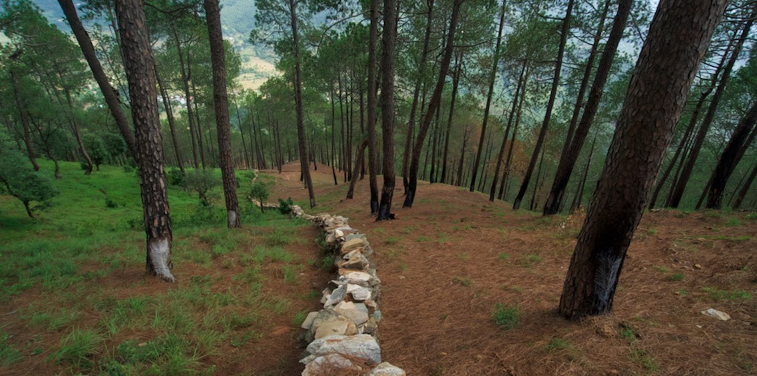
It is a dry stone wall in the community forest.
The wall (3.15km, 1m height, 80 cm width) is 40 years old and is being regularly maintained. The community is currently extending it to 4km.
3. Purpose and function of the technology:-
To protect the forest from forest fires.
To protect the fodder grasses from grazing animals
To protect the community forest from encroachment
To make a margin between two community forests.
4. Major activities and inputs needed to establish and maintain the technology:
Obtaining funding and external support to make the stone wall from other agencies (JICA, Forest Department)
The Forest department and Nakina Van Panchayat were the implementing agencies, and received approval from the District Magistrate to build the wall.
Nakina Van Panchayat organized the community people to construct the wall, paying each person 400 INR ($5.20 USD) a day for their work.
The community pooled their own construction materials and rocks were gathered on site.

5. Benefits and impacts of the Technology:
-Helps to protect forest fires from spreading to the Nakina community forest (physical barrier)
-Protect the fodder grasses from grazing animals
-Avoid conflict between two community forests and deter outsiders from crossing the wall

6. Impacts of the technology:
The wall is successful in protecting the forest from wildfire and it inhibits wildlife/livestock movements or passage.
The people of Nakina village are restricted to a particular area to collect fodder and forest products, which helps them regulate and realize their specific resource demands. This helps them avoid overexploitation of forest resources and set limits.

People views about the technology:-
Like: People are very positive about this technology and they believe that extending its length from 3.15km to 4km will further benefit the forest.
Dislike: The aesthetic of the forest is slightly compromised due to the construction wall.
During construction period, the people realized that some noise pollution from breaking stones could have disturbed neighbors grazing their livestock or other wildlife

Location

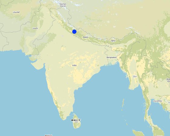
Location: Naikina Village, Pithoragarh Bloc, Uttarakhand, India

No. of Technology sites analysed: single site

Geo-reference of selected sites
  • 80.16771, 29.63052
  • 80.16874, 29.63098
  • 80.16846, 29.62902
  • 80.17011, 29.63045

Spread of the Technology: evenly spread over an area (approx. 0.1-1 km2)

In a permanently protected area?: Yes

Date of implementation: 10-50 years ago

Type of introduction
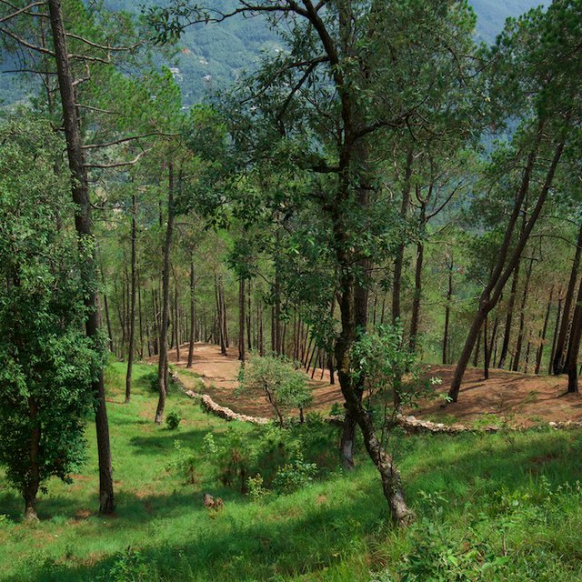
Stone Wall: Lush fodder in the protected Nakina Forest (Hanspeter Liniger)
Aerial view of Community Forest Demarcation (Hanspeter Liniger)

Classification of the Technology

Main purpose
  • improve production
  • reduce, prevent, restore land degradation
  • conserve ecosystem
  • protect a watershed/ downstream areas – in combination with other Technologies
  • preserve/ improve biodiversity
  • reduce risk of disasters
  • adapt to climate change/ extremes and its impacts
  • mitigate climate change and its impacts
  • create beneficial economic impact
  • create beneficial social impact
Land use
Land use mixed within the same land unit: Yes - Silvo-pastoralism

  • Grazing land
    • Cut-and-carry/ zero grazing
    Animal type: cattle - dairy, goats
    Is integrated crop-livestock management practiced? Yes
    Products and services: meat, milk
      SpeciesCount
      cattle - dairyn.a.
      goatsn.a.
    • Forest/ woodlands
      • Tree plantation, afforestation: subtropical dry forest plantation - Broadleaf. Varieties: Monoculture local variety
      Tree types (deciduous): n.a.
      Products and services: Timber, Fuelwood, Grazing/ browsing

    Water supply
    • rainfed
    • mixed rainfed-irrigated
    • full irrigation

    Purpose related to land degradation
    • prevent land degradation
    • reduce land degradation
    • restore/ rehabilitate severely degraded land
    • adapt to land degradation
    • not applicable
    Degradation addressed
    • soil erosion by water - Wt: loss of topsoil/ surface erosion, Wg: gully erosion/ gullying, Wm: mass movements/ landslides
    • biological degradation - Bc: reduction of vegetation cover, Bh: loss of habitats, Bq: quantity/ biomass decline, Bf: detrimental effects of fires, Bs: quality and species composition/ diversity decline, Bl: loss of soil life
    SLM group
    • natural and semi-natural forest management
    SLM measures
    • structural measures - S6: Walls, barriers, palisades, fences
    • management measures - M1: Change of land use type, M2: Change of management/ intensity level

    Technical drawing

    Technical specifications
    Length: 3.15 km
    315 m (l) x 0.75 (w) x 0.5 m (h) = 118 m3

    Firebreak: 2m of littler is cleared on each side of the wall (1x per year during the dry season, after pine needles drop in April/May)
    Author: Jaclyn Bandy

    Establishment and maintenance: activities, inputs and costs

    Calculation of inputs and costs
    • Costs are calculated: per Technology unit (unit: Protective stone wall volume, length: 3.15 km)
    • Currency used for cost calculation: INR
    • Exchange rate (to USD): 1 USD = 70.0 INR
    • Average wage cost of hired labour per day: 400 INR / person
    Most important factors affecting the costs
    Labor availability, extent of structural damage to the wall
    Establishment activities
    1. Agreement between Nakina Van Panchayat, JICA and Forest Department for project implementation (Timing/ frequency: Winter)
    2. Wall Preparation: Site demarcation, clearing of brush, vegetation, collection of stones (Timing/ frequency: Winter)
    3. Random rubble stones of all shapes and sizes are chiseled; inconvenient edges are chipped off (Timing/ frequency: Winter)
    4. Stones are piled on top of one another without mortar, and laid in irregular horizontal courses. (Timing/ frequency: Winter)
    5. Regular monitoring by administrative committee on the construction site (Timing/ frequency: Year round)
    6. Clearing dry pine needles around the dry stone (2m on each side of the wall) annually in the dry season. (Timing/ frequency: April/May)
    Establishment inputs and costs (per Protective stone wall)
    Specify input Unit Quantity Costs per Unit (INR) Total costs per input (INR) % of costs borne by land users
    Labour
    Unskilled, semi-skilled work (community) person/day 4200.0 400.0 1680000.0 100.0
    Skilled (technical experts, trained construction workers) person/day 50.0 2000.0 100000.0 100.0
    Equipment
    Pick pieces 15.0 300.0 4500.0 100.0
    shovel pieces 20.0 500.0 10000.0 100.0
    pharuwa (hoe) pieces 15.0 300.0 4500.0 100.0
    khanti (digging bar) pieces 10.0 1500.0 15000.0 100.0
    hammer (5kg) pieces 10.0 2000.0 20000.0 100.0
    chino (chisel) pieces 10.0 500.0 5000.0 100.0
    Khukuri (knife) pieces 10.0 250.0 2500.0 100.0
    Small hammer (0.5-1kg) pieces 15.0 300.0 4500.0 100.0
    Total costs for establishment of the Technology 1'846'000.0
    Total costs for establishment of the Technology in USD 26'371.43
    Maintenance activities
    1. Maintaining small damages to wall structure (Timing/ frequency: Year-round)
    2. Emergency tending to large sites of damage (Timing/ frequency: Monsoon)
    3. Frequent visitations during the dry season/fire season (Timing/ frequency: Pre monsoon)
    4. Firebreak establishment: clearing of pine needs 2m on each side of the wall (Timing/ frequency: Peak Dry season)
    Maintenance inputs and costs (per Protective stone wall)
    Specify input Unit Quantity Costs per Unit (INR) Total costs per input (INR) % of costs borne by land users
    Labour
    Unskilled/semiskilled person-days 100.0 400.0 40000.0 100.0
    Skilled person-days 10.0 2000.0 20000.0 100.0
    Equipment
    Picks pieces 10.0 300.0 3000.0 100.0
    Shovel pieces 10.0 500.0 5000.0 100.0
    pharuwa (hoe) pieces 7.0 300.0 2100.0 100.0
    khanti (digging bar) pieces 7.0 1500.0 10500.0 100.0
    hammer pieces 5.0 2000.0 10000.0 100.0
    chino (chisel) pieces 9.0 500.0 4500.0 100.0
    khukuri (knife) pieces 5.0 250.0 1250.0 100.0
    small hammer pieces 15.0 300.0 4500.0 100.0
    Total costs for maintenance of the Technology 100'850.0
    Total costs for maintenance of the Technology in USD 1'440.71

    Natural environment

    Average annual rainfall
    • < 250 mm
    • 251-500 mm
    • 501-750 mm
    • 751-1,000 mm
    • 1,001-1,500 mm
    • 1,501-2,000 mm
    • 2,001-3,000 mm
    • 3,001-4,000 mm
    • > 4,000 mm
    Agro-climatic zone
    • humid
    • sub-humid
    • semi-arid
    • arid
    Specifications on climate
    Average annual rainfall in mm: 1500.0
    Monsoon- mid-June to mid-September; July and August are the rainiest months and the temperature is warm and moist; between 70-85% of the annual precipitation occurs in the monsoon season
    Name of the meteorological station: India Meteorological Department, Meteorological Centre Dehradun
    The overall climatic condition in the Pithoragarh district is governed by the southwest monsoon. It has a sub-tropical to temperate climate, with three pronounced seasons; summer, winter, and monsoon. The hilly terrain of the Himalayan region has snow cover and is cold during winter with snowfall normally occurring during the months of December to March.

    Temperature- The temperature ranges from 0°C to 10°C in winter and from 8°C to 33°C in summer season. However, there is no meteorological observatory in the district. The account of the climate is based mainly on the records of the observations in the neighboring districts where similar meteorological conditions prevail. Variations in temperature are considerable from place to place and depend upon elevation as well as aspect. As the insolation is intense at high altitudes, in summer temperatures are considerably higher in the open than in the shade.
    Slope
    • flat (0-2%)
    • gentle (3-5%)
    • moderate (6-10%)
    • rolling (11-15%)
    • hilly (16-30%)
    • steep (31-60%)
    • very steep (>60%)
    Landforms
    • plateau/plains
    • ridges
    • mountain slopes
    • hill slopes
    • footslopes
    • valley floors
    Altitude
    • 0-100 m a.s.l.
    • 101-500 m a.s.l.
    • 501-1,000 m a.s.l.
    • 1,001-1,500 m a.s.l.
    • 1,501-2,000 m a.s.l.
    • 2,001-2,500 m a.s.l.
    • 2,501-3,000 m a.s.l.
    • 3,001-4,000 m a.s.l.
    • > 4,000 m a.s.l.
    Technology is applied in
    • convex situations
    • concave situations
    • not relevant
    Soil depth
    • very shallow (0-20 cm)
    • shallow (21-50 cm)
    • moderately deep (51-80 cm)
    • deep (81-120 cm)
    • very deep (> 120 cm)
    Soil texture (topsoil)
    • coarse/ light (sandy)
    • medium (loamy, silty)
    • fine/ heavy (clay)
    Soil texture (> 20 cm below surface)
    • coarse/ light (sandy)
    • medium (loamy, silty)
    • fine/ heavy (clay)
    Topsoil organic matter content
    • high (>3%)
    • medium (1-3%)
    • low (<1%)
    Groundwater table
    • on surface
    • < 5 m
    • 5-50 m
    • > 50 m
    Availability of surface water
    • excess
    • good
    • medium
    • poor/ none
    Water quality (untreated)
    • good drinking water
    • poor drinking water (treatment required)
    • for agricultural use only (irrigation)
    • unusable
    Water quality refers to: ground water
    Is salinity a problem?
    • Yes
    • No

    Occurrence of flooding
    • Yes
    • No
    Species diversity
    • high
    • medium
    • low
    Habitat diversity
    • high
    • medium
    • low

    Characteristics of land users applying the Technology

    Market orientation
    • subsistence (self-supply)
    • mixed (subsistence/ commercial)
    • commercial/ market
    Off-farm income
    • less than 10% of all income
    • 10-50% of all income
    • > 50% of all income
    Relative level of wealth
    • very poor
    • poor
    • average
    • rich
    • very rich
    Level of mechanization
    • manual work
    • animal traction
    • mechanized/ motorized
    Sedentary or nomadic
    • Sedentary
    • Semi-nomadic
    • Nomadic
    Individuals or groups
    • individual/ household
    • groups/ community
    • cooperative
    • employee (company, government)
    Gender
    • women
    • men
    Age
    • children
    • youth
    • middle-aged
    • elderly
    Area used per household
    • < 0.5 ha
    • 0.5-1 ha
    • 1-2 ha
    • 2-5 ha
    • 5-15 ha
    • 15-50 ha
    • 50-100 ha
    • 100-500 ha
    • 500-1,000 ha
    • 1,000-10,000 ha
    • > 10,000 ha
    Scale
    • small-scale
    • medium-scale
    • large-scale
    Land ownership
    • state
    • company
    • communal/ village
    • group
    • individual, not titled
    • individual, titled
    Land use rights
    • open access (unorganized)
    • communal (organized)
    • leased
    • individual
    Water use rights
    • open access (unorganized)
    • communal (organized)
    • leased
    • individual
    Access to services and infrastructure
    health

    poor
    good
    education

    poor
    good
    technical assistance

    poor
    good
    employment (e.g. off-farm)

    poor
    good
    markets

    poor
    good
    energy

    poor
    good
    roads and transport

    poor
    good
    drinking water and sanitation

    poor
    good
    financial services

    poor
    good
    Comments

    The situation of infrastructure is difficult and inconsistent in the hill regions because of the terrain. The major infrastructural issues are drinking water and irrigation facilities, electricity, transportation and communication facilities and social infrastructure (housing and education). As for financial services, only the State Bank of India (SBI) is active in the hill regions where it is trying to achieve the objective of 100% financial inclusion. Some villages mentioned buying into into agricultural insurance in the past, however this was a temporary enterprise and they were never compensated after extreme climatic events that occurred and damaged over 70% of their crop. Though infrastructure and education has generally improved over the years, institutional and marketing networks in the region aimed at supporting hill-farmers are lacking.

    Impacts

    Socio-economic impacts
    fodder production
    decreased
    increased

    Quantity before SLM: 2 ton/hectare
    Quantity after SLM: 10 ton/hectare

    fodder quality
    decreased
    increased


    More broadleaf species

    wood production
    decreased
    increased


    Fuelwood from broadleaved species is more plentiful

    forest/ woodland quality
    decreased
    increased


    Less pine encroachment and fire damage, tree lopping for fodder decreased by 15%

    non-wood forest production
    decreased
    increased


    Resin collection has increased, pines residing in the protected forest are not damaged by the fire

    production area (new land under cultivation/ use)
    decreased
    increased


    Rehabilitated areas that had previously been barren or overgrazed

    land management
    hindered
    simplified


    Less dispute over land resources with a clear demarcation

    water availability for livestock
    decreased
    increased

    expenses on agricultural inputs
    increased
    decreased


    Less damage to plantation and fodder grasses, improved survivability of saplings and decreased costs of supplementary fodder

    economic disparities
    increased
    decreased


    Decreased fodder availability gap during dry season

    workload
    increased
    decreased


    Women have saved approximately 1-2 hours in fodder collection

    Socio-cultural impacts
    food security/ self-sufficiency
    reduced
    improved


    Milk production of the livestock has increased due to improved fodder availability/quality

    land use/ water rights
    worsened
    improved

    cultural opportunities (eg spiritual, aesthetic, others)
    reduced
    improved


    Improved forest quality and aesthetic of forest surrounding the temple

    recreational opportunities
    reduced
    improved

    community institutions
    weakened
    strengthened

    SLM/ land degradation knowledge
    reduced
    improved


    Increased attention to landscape features and execution of SLM interventions within the community and Van Panchayat

    conflict mitigation
    worsened
    improved

    situation of socially and economically disadvantaged groups (gender, age, status, ehtnicity etc.)
    worsened
    improved

    Ecological impacts
    water quantity
    decreased
    increased


    Improved infiltration and soil WHC

    harvesting/ collection of water (runoff, dew, snow, etc)
    reduced
    improved

    surface runoff
    increased
    decreased

    groundwater table/ aquifer
    lowered
    recharge

    evaporation
    increased
    decreased

    soil moisture
    decreased
    increased

    soil cover
    reduced
    improved

    soil loss
    increased
    decreased

    soil accumulation
    decreased
    increased

    soil crusting/ sealing
    increased
    reduced

    soil compaction
    increased
    reduced

    nutrient cycling/ recharge
    decreased
    increased

    soil organic matter/ below ground C
    decreased
    increased

    vegetation cover
    decreased
    increased

    biomass/ above ground C
    decreased
    increased

    plant diversity
    decreased
    increased

    invasive alien species
    increased
    reduced

    beneficial species (predators, earthworms, pollinators)
    decreased
    increased

    habitat diversity
    decreased
    increased

    landslides/ debris flows
    increased
    decreased

    drought impacts
    increased
    decreased

    impacts of cyclones, rain storms
    increased
    decreased

    fire risk
    increased
    decreased

    micro-climate
    worsened
    improved

    Off-site impacts
    water availability (groundwater, springs)
    decreased
    increased

    reliable and stable stream flows in dry season (incl. low flows)
    reduced
    increased

    buffering/ filtering capacity (by soil, vegetation, wetlands)
    reduced
    improved

    Cost-benefit analysis

    Benefits compared with establishment costs
    Short-term returns
    very negative
    very positive

    Long-term returns
    very negative
    very positive

    Benefits compared with maintenance costs
    Short-term returns
    very negative
    very positive

    Long-term returns
    very negative
    very positive

    The work load is quite high for establishment and maintenance of the wall, especially when there is significant damage. Although upkeep can be demanding, the community sees the benefit of their efforts. This is especially recognized when the wall is secure from all sides and the firebreak is established before the fire season begins.

    Climate change

    Gradual climate change
    annual temperature increase

    not well at all
    very well
    Rainfall intensity increase

    not well at all
    very well
    Climate-related extremes (disasters)
    local thunderstorm

    not well at all
    very well
    local hailstorm

    not well at all
    very well
    drought

    not well at all
    very well
    forest fire

    not well at all
    very well
    flash flood

    not well at all
    very well
    landslide

    not well at all
    very well

    Adoption and adaptation

    Percentage of land users in the area who have adopted the Technology
    • single cases/ experimental
    • 1-10%
    • 11-50%
    • > 50%
    Of all those who have adopted the Technology, how many have done so without receiving material incentives?
    • 0-10%
    • 11-50%
    • 51-90%
    • 91-100%
    Has the Technology been modified recently to adapt to changing conditions?
    • Yes
    • No
    To which changing conditions?
    • climatic change/ extremes
    • changing markets
    • labour availability (e.g. due to migration)
    The wall is being extended from 3.15 km long to 4 km. The reasoning behind this is that the community believes that it will help protect the forest at a greater scale from wildfire, as the frequency is increasing due to climate change, neglect of forest management and historical pine plantations.

    Conclusions and lessons learnt

    Strengths: land user's view
    • Provides protection of the forest from forest fires and livestock grazing
    • More fuelwood and fodder is made available through this protective border
    • Because of determent from grazing and other intruders (human/wildlife), saplings and grasses are protected. This has improved the health of the forest, increased groundwater availability and improved spring recharge due to slowing surface runoff and better infiltration rates within the forest.
    Strengths: compiler’s or other key resource person’s view
    • In agreement with the landuser
    Weaknesses/ disadvantages/ risks: land user's viewhow to overcome
    • Height of the wall can be too short to act as an effective barrier for intense forest fires. The lack of height can compromised by clearing the pine needles and creating a firebreak on both sides of the wall one additional meter. Placement of vegetation where dryer areas exist (or near grassy meadows) may also act as an effective biological barrier against the fires.
    • Parts of the wall on steep slopes often get damaged or destroyed Avoid building the wall on steep slopes. If there are vulnerable areas, other reinforcement or alternative building technique maybe necessary. For example, building with the incline of the slope into the mountain side, so that the wall acts as more of a retaining structure.
    Weaknesses/ disadvantages/ risks: compiler’s or other key resource person’s viewhow to overcome
    • The stone wall's function is only as good as its construction. Some parts of the wall appear to be built in a secure, durable manner whereas other parts could be easily perturbed by pressure or vibration. Proper training on engineering a stable wall would benefit the technology and reduce maintenance. Perhaps an external technical person could supervise wall-restoration and make periodic checks. Emphasizing the importance of diligent work on construction can be encouraged and incentivized with a higher wage (e.g. 600 INR instead of 400).
    • Stone walls have inherent weaknesses against the lateral forces of earthquake. Poorly constructed walls having inadequate interlocking between the inside and the outside faces begin to separate,
      resulting in to rapid weakening of the wall. Assure sure that the measures required to counter these weaknesses are taken during the construction so that in the event of a potentially destructive earthquake, the structure is able to withstand its impact without suffering much damage. It is best to build in areas that have firm soil or rock underneath the topsoil. Soft soils can amplify wall movement during an earthquake.

    References

    Compiler
    • Jaclyn Bandy
    Editors
    Reviewer
    • Hanspeter Liniger
    Date of documentation: July 26, 2019
    Last update: June 27, 2021
    Resource persons
    Full description in the WOCAT database
    Linked SLM data
    Documentation was faciliated by
    Institution Project
    Key references
    • A TUTORIAL: Improving the Seismic Performance of Stone Masonry Buildings, Jitendra Bothara, Svetlana Brzevm, 2011, ISBN: 978-1-932884-48-7: https://www.academia.edu/20998004/A_TUTORIAL_Improving_the_Seismic_Performance_of_Stone_Masonry_Buildings
    Links to relevant information which is available online
    This work is licensed under Creative Commons Attribution-NonCommercial-ShareaAlike 4.0 International