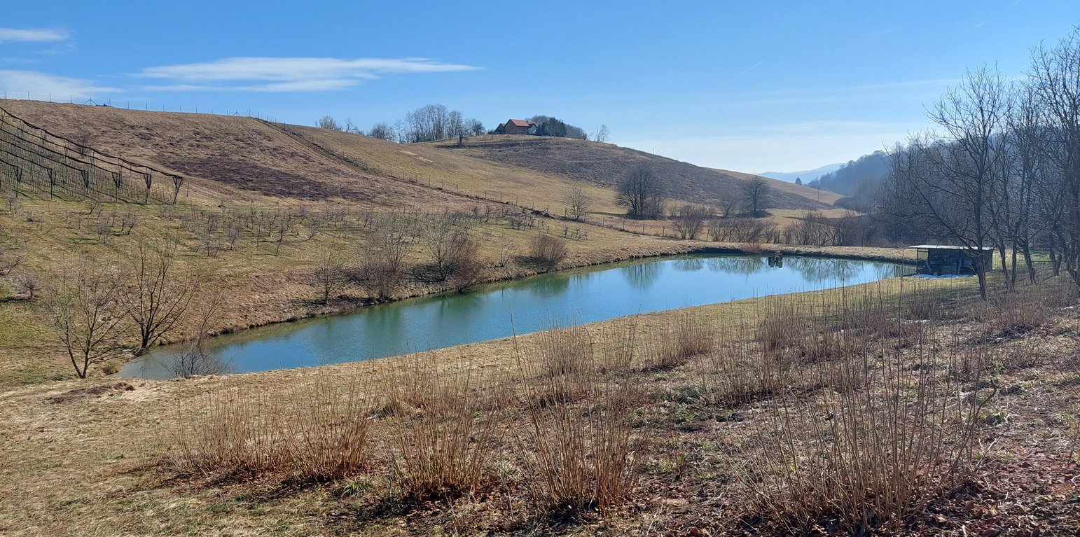
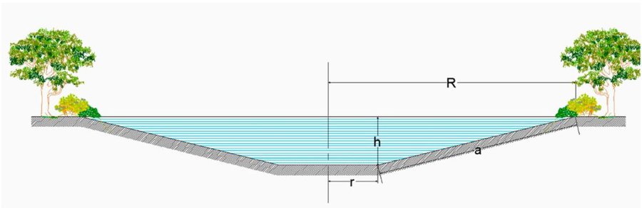
Retention pond in demonstration plantation centre Maribor. (Gregor Kramberger)

Retention ponds (Slovenia)

Mokri zadrževalniki vode

Description

Retention ponds (e.g. flood storage reservoirs, shallow impoundments) are water bodies, storing water to attenuate surface runoff during rainfall events. They provide storage as well as improving water quality. Retention ponds may also be used for irrigation of farmland.

“Retention ponds” comprise both simple, small ponds (up to 2000 m3, up to 4 m deep) and larger, more complex reservoirs (greater than 2000 m3). Retention ponds are designed to provide storage capacity to attenuate surface runoff during rainfall events. Each consists of a permanent ponded area with landscaped banks. Retention ponds achieve both storm water attenuation and water quality treatment through supplementary storage capacity of runoff. Water is then released at a controlled rate once the risk of flooding has passed. The technology can be applied in a natural or human environment. Before construction of a pond it is essential to follow legislation, which covers conditions and restrictions for the given location. Once a site is selected, technical documentation is prepared: first the conceptual design, then documentation for obtaining opinion, consent and a building permit. Later there is also project documentation for implementation. If the water is to be used for other purposes as well (e.g. for irrigation), it is necessary to plan for usage and environmental impact. Retention and still water promotes pollutant removal through sedimentation, while aquatic vegetation and biological uptake mechanisms offer additional treatment. Retention ponds are effective in removing urban pollutants and improving water quality.
They are created either by using an existing natural depression, or by excavating a new depression, or by constructing embankments. Existing natural water bodies should not be used however, due to the risk that pollution events and poorer water quality might disturb/damage the natural ecology of the system. A great benefit of retention ponds is that they hold water when there is an excess of it, which can be used later when water is not available (e.g. for irrigation). Irrigation users are farmers, so they see the advantage of using a retention system. In addition to irrigation, water has also been needed in recent years for anti-frost systems (sprinkling a consistent layer of water on the crop during an entire frost event until temperatures are back to safe levels). Disadvantages are mainly restrictions in some areas (e.g. protected areas), preparation of demanding documentation and bureaucracy, and lengthy procedures for obtaining permits.

Location

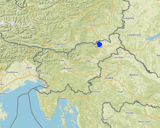
Location: Pesnica, Podravska region, Slovenia, Slovenia

No. of Technology sites analysed: 2-10 sites

Geo-reference of selected sites
  • 15.6842, 46.61512
  • 15.65148, 46.59821
  • 15.63917, 46.63365

Spread of the Technology: applied at specific points/ concentrated on a small area

In a permanently protected area?: No

Date of implementation: 10-50 years ago

Type of introduction
Pond where water accumulates along the stream Kobiljski potok. (Gregor Kramberger)
The pond along the Pesnica river is also intended for recreation and tourism. (Gregor Kramberger)

Classification of the Technology

Main purpose
  • improve production
  • reduce, prevent, restore land degradation
  • conserve ecosystem
  • protect a watershed/ downstream areas – in combination with other Technologies
  • preserve/ improve biodiversity
  • reduce risk of disasters
  • adapt to climate change/ extremes and its impacts
  • mitigate climate change and its impacts
  • create beneficial economic impact
  • create beneficial social impact
Land use
Land use mixed within the same land unit: No

  • Waterways, waterbodies, wetlands - Ponds, dams
    Main products/ services: Retention of water, collection of water. Retention ponds are ponds or basins designed with additional storage capacity to attenuate surface runoff during rainfall events. In dry years, the water can be used for agriculture, e.g. for irrigation.

Water supply
  • rainfed
  • mixed rainfed-irrigated
  • full irrigation

Purpose related to land degradation
  • prevent land degradation
  • reduce land degradation
  • restore/ rehabilitate severely degraded land
  • adapt to land degradation
  • not applicable
Degradation addressed
  • soil erosion by water - Wt: loss of topsoil/ surface erosion, Wg: gully erosion/ gullying, Wo: offsite degradation effects
  • biological degradation - Bc: reduction of vegetation cover, Bh: loss of habitats, Bq: quantity/ biomass decline, Bs: quality and species composition/ diversity decline, Bp: increase of pests/ diseases, loss of predators
  • water degradation - Ha: aridification, Hs: change in quantity of surface water, Hg: change in groundwater/aquifer level, Hp: decline of surface water quality, Hq: decline of groundwater quality
SLM group
  • water harvesting
  • irrigation management (incl. water supply, drainage)
  • surface water management (spring, river, lakes, sea)
SLM measures
  • structural measures - S5: Dams, pans, ponds

Technical drawing

Technical specifications
Water retention pond – excavation scheme. R is the top radius of pond, while r is the base radius; h is the height and a refers to the bank slope. Storage volume is estimated by radius r and height h (Figure). We consider potential storage volumes of 5,000 m3 to 10,000 m3.
Prior to start of construction, detention/retention ponds should be designed by a registered design professional. Plans and specifications should be referred to by field personnel throughout the construction process. When placing a detention/retention pond in a space in the first phase it is necessary to produce a conceptual design of the intended construction of a pond, which must show the purpose and goals of the retaining wall, the size of the pond, the location, a list of plots that are encroached upon, distances from neighboring land and neighboring buildings, anticipated activities in the impoundment area, impoundment volume, barrier size data, including stability assessment, and geotechnical data (Hočuršćak 2017). When planning construction of the pond, attention should be paid primarily to the impact on the actual use of space from the point of view of water management regulations, which defines the area of use and activity restrictions, due to the possible negative impact on water and coastal lands, aquatic habitats and the ecosystem created by the construction of the reservoir. After talking with the designer, in order to obtain a water permit and consent from the authorities, it is necessary to prepare technical documentation for the installation and construction, which must also include the basis for monitoring operation and maintenance (Hočuršćak 2017). The technical documentation (dimensioning of the reservoir) may differ from the microlocation and purpose or use of the measure, e.g. if pool is intended only to contain high water, sediment or debris laoding, will it be inhabited by aquatic animals, will water be used for irrigation, drinking, etc. We also consider the shape and size of the area to identify those better suited for allocating ponds also in terms of space availability. For example, it is necessary to exclude locations with a greater slope and distance from the river considering higher slope and distance is more difficult and costly to construct. We also exclude locations where the construction of a pond is not possible because they are too narrow or too small. We should consider water retention ponds as elements of a green infrastructure network together with other natural elements (e.g. vegetated riparian zones) and protected areas (e.g. Natura, 2000 sites) with a pond design that embeds features that enhance their ecological functionality. These include mild-sloped sides with vegetated buffers along the shorelines and vegetated floating islands that facilitate the nesting of birds. We refer to excavated ponds, with no weirs or dams, since inline ponds are more costly and may have negative ecological impacts (A. Staccione et al. 2021).

Presentation of the water reservoir at the Sadjarski Center Maribor (translated: Fruit Growing Center Maribor):
The Sadjarski Center Maribor is located on a sloping terrain, which is pedologically and configuratively quite diverse, with slopes ranging from 5-15%. The soil structure is clayey loam with a basaltic substrate. In the lower, flatter part, the soil was waterlogged, which was resolved through drainage systems. These drains are directed towards a drainage ditch, which serves as the foundation for the pond and is fed by two smaller springs. The intake point is located at the lowest point and at the southernmost part of the complex. It covers an area of 3000 m2 and has a depth of up to 3.8 m. Its capacity is 5500 m3 of water when fully filled. At its southern part, there is a concrete overflow structure (spillway) with a height of 3.8 m, which is used to drain excess water and regulate the water level. A concrete pipe, 20 m in length and 80 cm in diameter, is connected to it for the discharge of excess water. On the western side, a concrete pumping platform with a canopy and an oil trap has been constructed. It houses a 185 kW (252 HP) DAF diesel generator and a Capprari flow pump with a capacity of 300 l/min (18.0 m3/h). The pumping unit is used for filling the reservoir of the irrigation fertigation system.
Author: A. Staccione et al.

Establishment and maintenance: activities, inputs and costs

Calculation of inputs and costs
  • Costs are calculated: per Technology unit (unit: pond volume, length: 5500)
  • Currency used for cost calculation: EUR
  • Exchange rate (to USD): 1 USD = 0.97 EUR
  • Average wage cost of hired labour per day: 90.90
Most important factors affecting the costs
Construction costs are affected by the shape, size, depth and microlocation of the pond layout. In addition, the cost is also influenced by the purpose of use (e.g. if pool is intended only to contain high water, sediment or debris laoding, will it be inhabited by aquatic animals, will water be used for irrigation, drinking, etc.). Geomechanically conditions are also important, because ponds and reservoirs can affect slope stability and induce landslides. The value of the investment can vary greatly depending on the design of the pond, location, water content of the area, soil structure, climate conditions,... so it is impossible to determine the exact values for pond construction, but we can only give an estimation.
Establishment activities
  1. Costs of obtaining construction, technical and project documentation (Timing/ frequency: 1-2 years before before starting construction)
  2. Construction of a pond (Timing/ frequency: 1st year)
  3. Costs of supervision of construction and craftsmanship (Timing/ frequency: 1st year)
Total establishment costs (estimation)
73600.0
Maintenance activities
  1. Energy for pumping (Timing/ frequency: annually)
  2. water fee (Timing/ frequency: annually)
  3. Maintenance costs (vegetation management, inspections, infrastructure maintenance, mulching, invasive species removal, pumping the entire pond for cleaning and sediment removal, sludge cleaning, monitoring, bank stabilization, replacement of damaged parts, and sealing, etc.) (Timing/ frequency: annually)
Total maintenance costs (estimation)
3000.0

Natural environment

Average annual rainfall
  • < 250 mm
  • 251-500 mm
  • 501-750 mm
  • 751-1,000 mm
  • 1,001-1,500 mm
  • 1,501-2,000 mm
  • 2,001-3,000 mm
  • 3,001-4,000 mm
  • > 4,000 mm
Agro-climatic zone
  • humid
  • sub-humid
  • semi-arid
  • arid
Specifications on climate
Average annual rainfall in mm: 1080.0
The most precipitation falls in summer, the months with the highest average precipitation are June and August, the least precipitation falls in winter, in January and February at least, and in principle more precipitation falls in autumn than in spring.
Name of the meteorological station: Jareninski vrh (1981 – 2010)
Mean annual temperature in year 2014 Jareninski vrh is 11,9°C.
Slope
  • flat (0-2%)
  • gentle (3-5%)
  • moderate (6-10%)
  • rolling (11-15%)
  • hilly (16-30%)
  • steep (31-60%)
  • very steep (>60%)
Landforms
  • plateau/plains
  • ridges
  • mountain slopes
  • hill slopes
  • footslopes
  • valley floors
Altitude
  • 0-100 m a.s.l.
  • 101-500 m a.s.l.
  • 501-1,000 m a.s.l.
  • 1,001-1,500 m a.s.l.
  • 1,501-2,000 m a.s.l.
  • 2,001-2,500 m a.s.l.
  • 2,501-3,000 m a.s.l.
  • 3,001-4,000 m a.s.l.
  • > 4,000 m a.s.l.
Technology is applied in
  • convex situations
  • concave situations
  • not relevant
Soil depth
  • very shallow (0-20 cm)
  • shallow (21-50 cm)
  • moderately deep (51-80 cm)
  • deep (81-120 cm)
  • very deep (> 120 cm)
Soil texture (topsoil)
  • coarse/ light (sandy)
  • medium (loamy, silty)
  • fine/ heavy (clay)
Soil texture (> 20 cm below surface)
  • coarse/ light (sandy)
  • medium (loamy, silty)
  • fine/ heavy (clay)
Topsoil organic matter content
  • high (>3%)
  • medium (1-3%)
  • low (<1%)
Groundwater table
  • on surface
  • < 5 m
  • 5-50 m
  • > 50 m
Availability of surface water
  • excess
  • good
  • medium
  • poor/ none
Water quality (untreated)
  • good drinking water
  • poor drinking water (treatment required)
  • for agricultural use only (irrigation)
  • unusable
Water quality refers to: surface water
Is salinity a problem?
  • Yes
  • No

Occurrence of flooding
  • Yes
  • No
Species diversity
  • high
  • medium
  • low
Habitat diversity
  • high
  • medium
  • low

Characteristics of land users applying the Technology

Market orientation
  • subsistence (self-supply)
  • mixed (subsistence/ commercial)
  • commercial/ market
Off-farm income
  • less than 10% of all income
  • 10-50% of all income
  • > 50% of all income
Relative level of wealth
  • very poor
  • poor
  • average
  • rich
  • very rich
Level of mechanization
  • manual work
  • animal traction
  • mechanized/ motorized
Sedentary or nomadic
  • Sedentary
  • Semi-nomadic
  • Nomadic
Individuals or groups
  • individual/ household
  • groups/ community
  • cooperative
  • employee (company, government)
Gender
  • women
  • men
Age
  • children
  • youth
  • middle-aged
  • elderly
Area used per household
  • < 0.5 ha
  • 0.5-1 ha
  • 1-2 ha
  • 2-5 ha
  • 5-15 ha
  • 15-50 ha
  • 50-100 ha
  • 100-500 ha
  • 500-1,000 ha
  • 1,000-10,000 ha
  • > 10,000 ha
Scale
  • small-scale
  • medium-scale
  • large-scale
Land ownership
  • state
  • company
  • communal/ village
  • group
  • individual, not titled
  • individual, titled
Land use rights
  • open access (unorganized)
  • communal (organized)
  • leased
  • individual
Water use rights
  • open access (unorganized)
  • communal (organized)
  • leased
  • individual
Access to services and infrastructure
health

poor
good
education

poor
good
technical assistance

poor
good
employment (e.g. off-farm)

poor
good
markets

poor
good
energy

poor
good
roads and transport

poor
good
drinking water and sanitation

poor
good
financial services

poor
good

Impacts

Socio-economic impacts
Crop production
decreased
increased


Irrigation has avoided reduction in production due to drought and frost

crop quality
decreased
increased


Improved fruit health (protection against drought and frost)

risk of production failure
increased
decreased


Protection against drought and frost

production area (new land under cultivation/ use)
decreased
increased


Change of land use (from agricultural land to water body).

land management
hindered
simplified


Increased the complexity of management.

irrigation water quality
decreased
increased

demand for irrigation water
increased
decreased

farm income
decreased
increased


Production and income stability.

diversity of income sources
decreased
increased


Possible diversification on farm (tourism and recreation).

workload
increased
decreased


Demanding maintenance and increased complexity of management.

Socio-cultural impacts
food security/ self-sufficiency
reduced
improved


Lower risk of production failure, stability in business, motivation to do business in agriculture

recreational opportunities
reduced
improved


Possible additional activities on farm.

community institutions
weakened
strengthened


An example of good practice for the community.

SLM/ land degradation knowledge
reduced
improved


With positive effects more interest of the farmer in sustainable production.

Ecological impacts
water quantity
decreased
increased


Water available in dry months.

harvesting/ collection of water (runoff, dew, snow, etc)
reduced
improved

surface runoff
increased
decreased

excess water drainage
reduced
improved

evaporation
increased
decreased

soil moisture
decreased
increased


Increased in case of irrigation

soil loss
increased
decreased

nutrient cycling/ recharge
decreased
increased

vegetation cover
decreased
increased

plant diversity
decreased
increased


Planting species near/around the pond.

invasive alien species
increased
reduced


Danger in case of improper maintenance.

animal diversity
decreased
increased


For a green reservoir, a lot of green infrastructure is placed next to it, which serves as protection for animals and plants (beneficial).

beneficial species (predators, earthworms, pollinators)
decreased
increased

habitat diversity
decreased
increased

flood impacts
increased
decreased

landslides/ debris flows
increased
decreased

drought impacts
increased
decreased

fire risk
increased
decreased


Proximity to water.

micro-climate
worsened
improved


It affects the microclimate, more humidity, slower temperature fluctuations

Off-site impacts
water availability (groundwater, springs)
decreased
increased


It is slightly increased as the ponds provide water during dry periods.

reliable and stable stream flows in dry season (incl. low flows)
reduced
increased


Improved mainly due to water retention during wet seasons for use in dry periods.

downstream flooding (undesired)
increased
reduced


Reduced due to the capacity of ponds to retain excess water during times when rivers may flood.

downstream siltation
increased
decreased


The reservoir also enables sediment retention, preventing sediment from reaching downstream watercourses.

groundwater/ river pollution
increased
reduced


Many studies indicate that ponds can trap harmful substances, causing them to settle or undergo processes (acting as natural purification systems, especially when appropriate plant species are involved). This helps maintain cleaner downstream flows in terms of pollutants.

buffering/ filtering capacity (by soil, vegetation, wetlands)
reduced
improved


The pond's ability to retain pollutants also contributes to its buffering and filtering capacity.

Cost-benefit analysis

Benefits compared with establishment costs
Short-term returns
very negative
very positive

Long-term returns
very negative
very positive

Benefits compared with maintenance costs
Short-term returns
very negative
very positive

Long-term returns
very negative
very positive

The costs of establishing a retention pond are indeed very high, and it is a substantial investment. However, especially in the case of agricultural land irrigation, the benefits can be quite favorable, particularly in terms of drought protection or frost prevention. In the long run, the investment yields significant advantages, as it enables resilience to climate change. Farmers can also receive support through rural development programs, which provide 30-50% project funding. Although the maintenance costs can be considerable, they are necessary and offer substantial benefits to farmers who irrigate their crops or protect them from frost. From land users' perspective it's positive, if they have improved production results.

Climate change

Gradual climate change
seasonal temperature increase

not well at all
very well
Season: summer
annual rainfall decrease

not well at all
very well
seasonal rainfall increase

not well at all
very well
Season: spring
Climate-related extremes (disasters)
local rainstorm

not well at all
very well
heatwave

not well at all
very well
drought

not well at all
very well
general (river) flood

not well at all
very well
Other climate-related consequences
extended growing period

not well at all
very well

Adoption and adaptation

Percentage of land users in the area who have adopted the Technology
  • single cases/ experimental
  • 1-10%
  • 11-50%
  • > 50%
Of all those who have adopted the Technology, how many have done so without receiving material incentives?
  • 0-10%
  • 11-50%
  • 51-90%
  • 91-100%
Has the Technology been modified recently to adapt to changing conditions?
  • Yes
  • No
To which changing conditions?
  • climatic change/ extremes
  • changing markets
  • labour availability (e.g. due to migration)

Conclusions and lessons learnt

Strengths: land user's view
  • Retention ponds are simple if space is provided.
  • They collect water for use in drought conditions.
  • Retention ponds manage storm water quantity and quality, lessening the transfer of pollutants and chemicals into nearby water bodies.
  • Improved storm water collection and flood control.
  • Retention ponds provide habitats for animals, organisms, and insects (biodiversity).
Strengths: compiler’s or other key resource person’s view
  • Local farm water retention systems allow for the detainment of water captured during spring runoff as well as during precipitation events, either directly or due to transport by surface runoff. This provides water storage that can be drawn on when groundwater supplies become depleted.
  • Retention ponds are designed to hold excess storm water runoff and release it slowly to avoid flooding downstream areas. They also serve to reduce downstream peak flow and aid in retaining flood waters which reduces associated flood risks downstream. If water is released from the reservoir, they serve to replenish groundwater stores downstream.
  • Surface water retention systems have shown success in reducing nutrient and sediment loading in various locations worldwide.
  • Under drought conditions these systems enable farmers to draw water from the reservoirs to support crop irrigation. The main value of water retention ponds is related to agricultural water demand in the dry season. They are considered the only effective way to preserve agricultural productivity. The ponds can increase the monetary value of agricultural land that can cope with water needs.
  • In addition to the primary function of retaining high waters, they often also serve a multipurpose use, such as: supply of drinking water, irrigation of agricultural land, protection against erosion, aquaculture, fishing, energy source, preservation of landscape and biodiversity, tourism, recreation and others.
  • Biomass production is another benefit of multi-purpose surface water retention system – cattails bioproduction and nutrient management.
  • In the case of construction of the so-called of a "green" water reservoir, green infrastructure solutions can provide protection for various species of animals and plants, which promotes biodiversity.
Weaknesses/ disadvantages/ risks: land user's viewhow to overcome
  • Anaerobic conditions can occur without regular inflow. Proper planning and dimensioning of the pond, location and water level are necessary. It is necessary to ensure adequate flow and depth of the pond.
  • May not be suitable for steep sites, due to requirement for high embankments. The construction of the pond is planned at a suitable location.
  • Colonisation by invasive species could increase maintenance and pose a danger to cultivated areas. Regular maintenance and cleaning of the pond bank is necessary.
  • Safety risk in case of slipping and falling into the pond. It is necessary to fence and isolate the access to the pond.
Weaknesses/ disadvantages/ risks: compiler’s or other key resource person’s viewhow to overcome
  • Large investments in the irrigation system and access to funds for irrigation infrastructure can be difficult to attain. The size and holding capacity of retention systems also need to be considered to maximize benefits while limiting the initial costs of building a surface water retention system.
  • The construction requires a lot of technical preparation, planning, documentation and there are many bureaucratic obstacles to comply with the spatial acts of the municipality and to fulfil the requirements of the spatial planning authorities, which also includes large initial costs. The preparation and management of the project should be entrusted to a professional service. Check the conditions ahead of time and plan strategically several years ahead.
  • While irrigation provides an economic gain during drought years, it also increases operational costs for water supplies. Strategies need to provide drought proofing of crops as well as limiting damages caused by floods in non-drought years to reduce risk to farmers and the region.
  • Experts identified some barriers for greener pond implementation, especially related to reduced efficiency. The higher surface required can cause loss of water stored during summer from the higher rate of evaporation. Another risk is associated with vegetation close to the pond banks which can reduce impermeabilization and increase water infiltration due to root growth in the soil. Good technical plan with solutions and compromises for best results with natural (green) benefits. Considering the benefits brought by green systems.
  • Unregulated relations between active/potential users, both in the delimitation of water rights, especially in times of water shortage, and in cases of regulating obligations for the proper operation and maintenance. Collective investments with a good long-term plan for operation and maintenance. Organized management of users from the organization (e.g. municipality, etc.).

References

Compiler
  • Gregor Kramberger
Editors
Reviewer
  • William Critchley
  • Rima Mekdaschi Studer
Date of documentation: June 22, 2021
Last update: July 11, 2023
Resource persons
Full description in the WOCAT database
Linked SLM data
Documentation was faciliated by
Institution Project
Key references
  • An economic assessment of local farm multi-purpose surface water retention systems in a Canadian Prairie setting; Pamela Berry, Fuad Yassin, Kenneth Belcher, Karl-Erich Lindenschmidt, Appl Water Sci (2017) 7:4461–4478.: Web
  • Natural water retention ponds for water management in agriculture: A potential scenario in Northern Italy; Andrea Staccione, Davide Broccoli, Paolo Mazzoli, Stefano Bagli, Jaroslav Mysiak; Journal of Environmental Management 292 (2021) 112849.: Web
  • Natural Water Retention Measures; Report: Individual NWRM - Retention ponds.: Web
  • Vodnogospodarske podlage za nadzor obratovanja in vzdrževanja manjših zadrževalnikov. Miljenko Hočuršćak. Aktualni projekti s področja upravljanja z vodami in urejanje voda. 28. Mišičev vodarski dan 2017.: Web
This work is licensed under Creative Commons Attribution-NonCommercial-ShareaAlike 4.0 International