Rehabilitation of eroded land in the Mount Fletcher dam catchment, South Africa (J. Buckle)

Pitting to restore degraded catchment of Mount Fletcher Dam (South Africa)

Pits

Description

To improve infiltration and vegetation cover, by creating small pits on bare soil, which capture runoff and reduce erosion.

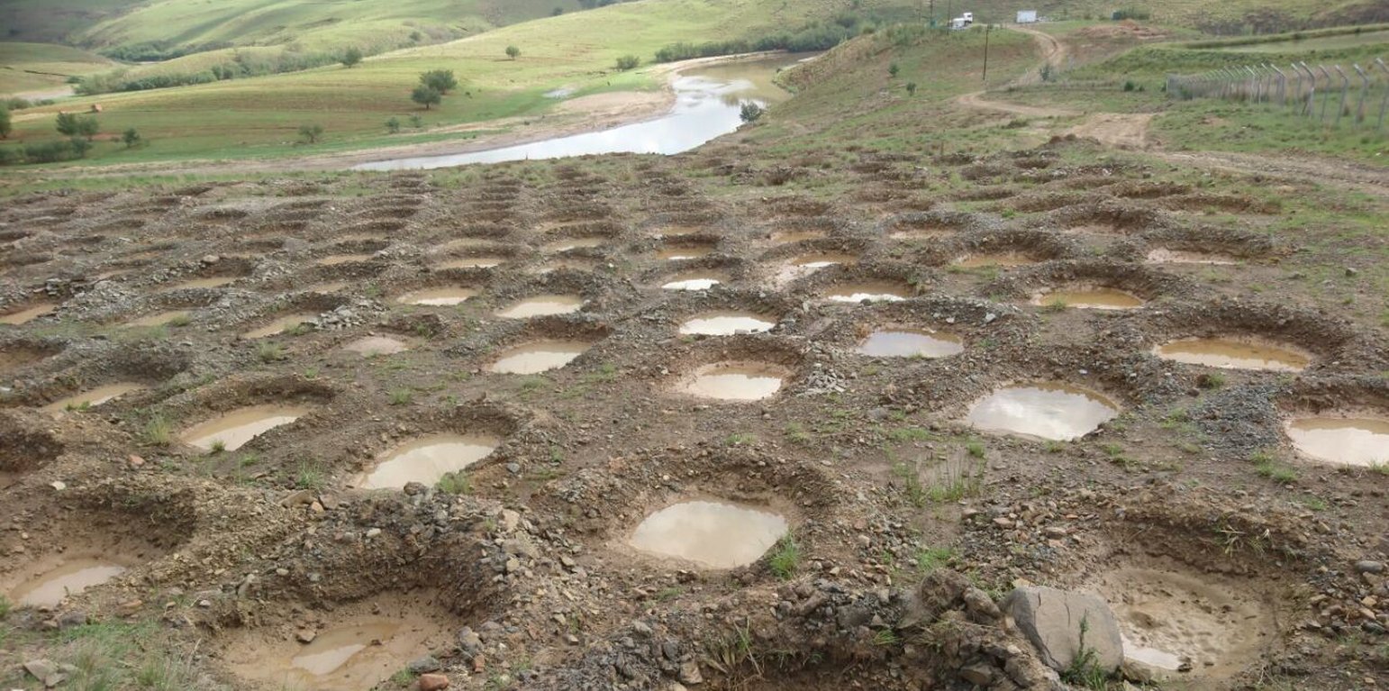
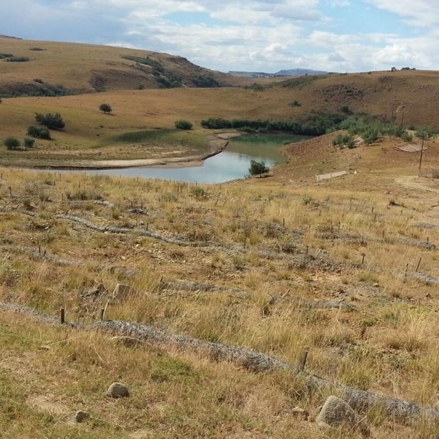
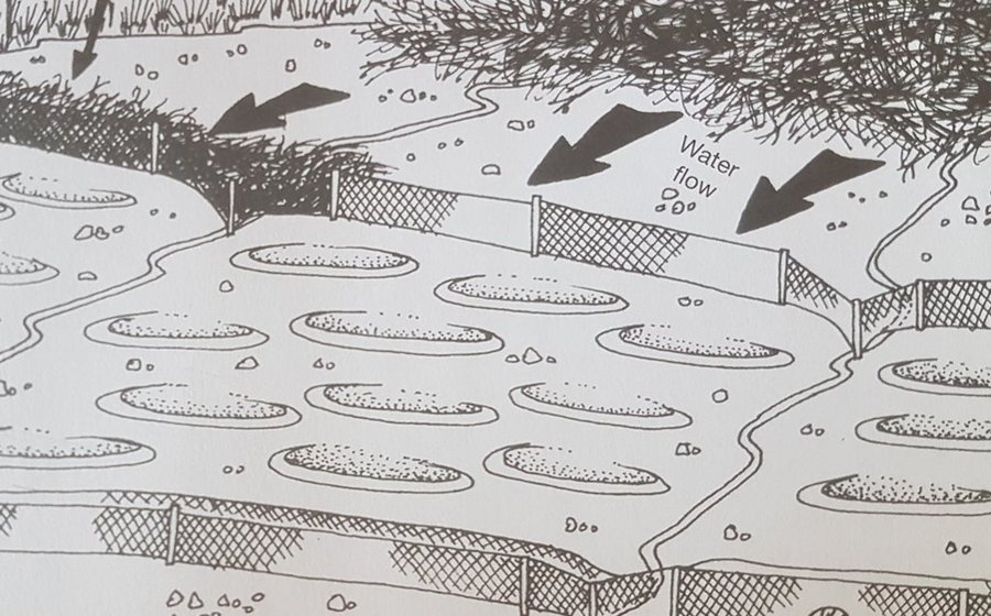
This project on pitting was implemented on the banks of the Mount Fletcher dam in the Eastern Cape of South Africa. The rehabilitation was funded by the Department of Environmental Affairs as part of the “Working on Ecosystems” programme. The programme also focuses on creating jobs and improving skill levels within local communities. The average annual rainfall in the area is 600 to 800 mm and occurs mainly in summer as thunderstorms. Severe sheet and rill erosion occur in the dam’s catchment. Combined with overgrazing and veld fires on the highly erodible soils, the catchment is severely degraded. Due to the degradation, high loads of sediment have resulted in severe siltation of the Mount Fletcher dam. The pitting technology can help. It is suitable for any low gradient, degraded, landscape as long as duplex soils are not present - due to piping on these soils. The main purpose of pitting is to enhance infiltration of runoff water by capturing, and ponding, it on capped/crusted bare soils. Simultaneously soil loss, due to sheet and rill erosion, is reduced. Secondary benefits of ponding runoff include trapping of sediment and subsequent improvement of vegetation cover. Pitting is combined with brush packing (laying cut bush on the soil’s surface) or mulching, and the construction of silt fences (low barriers across the slope) to further improve sediment trapping. This technology commences with the digging of small pits (70 cm surface diameter and 30 cm deep ) by hand or mechanical implements. The excavated soil is piled up to form a ridge on the down-slope. Pits are placed 2 meters apart in rows 1 meter apart. Re-seeding in pits with commercially available grass seed mixes can be used to enhance vegetation cover. Brush packing over the ponds with local woody (preferably thorny branches) material is recommended (if available locally) to provide protection against grazing and to create a micro-climate for vegetation growth. In between and above the pits silt fences or fiber rolls (can be used to slow water runoff (placed 10 m apart, across the slope).
Silt fences and fiber rolls are temporary sediment control devices used on rehabilitation sites to reduce sediment movement downhill. A typical fence consists of a piece of synthetic filter fabric (also called a geotextile) stretched between a series of wooden or metal fence stakes along a horizontal contour level. A fiber roll is made of wood fiber, straw, coconut fiber or similar material formed into a tubular roll also fixed by wooden or metal stakes.
Maintenance of the structures will include the creation of more pits and repair of silt fences and/or fiber rolls where needed. Further brush packing might be required after 6 months.

Location

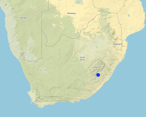
Location: Near the town of Mount Fletcher on the banks of the Mount Fletcher dam, Eastern Cape, South Africa

No. of Technology sites analysed: 10-100 sites

Geo-reference of selected sites
  • 28.47735, -30.62379

Spread of the Technology: evenly spread over an area (approx. 0.1-1 km2)

In a permanently protected area?:

Date of implementation: 2016

Type of introduction
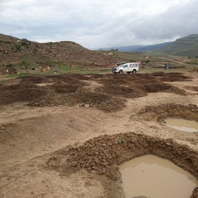
Runoff water ponded in pits after a thunderstorm (J Buckle)
Fibre rolls constructed between pits to slowdown water runoff (J Buckle)

Classification of the Technology

Main purpose
  • improve production
  • reduce, prevent, restore land degradation
  • conserve ecosystem
  • protect a watershed/ downstream areas – in combination with other Technologies
  • preserve/ improve biodiversity
  • reduce risk of disasters
  • adapt to climate change/ extremes and its impacts
  • mitigate climate change and its impacts
  • create beneficial economic impact
  • create beneficial social impact
Land use

  • Grazing land
    • Semi-nomadic pastoralism
    Animal type: cattle - dairy, goats, sheep
    Products and services: meat, milk
Water supply
  • rainfed
  • mixed rainfed-irrigated
  • full irrigation

Purpose related to land degradation
  • prevent land degradation
  • reduce land degradation
  • restore/ rehabilitate severely degraded land
  • adapt to land degradation
  • not applicable
Degradation addressed
  • soil erosion by water - Wt: loss of topsoil/ surface erosion, Wo: offsite degradation effects
  • physical soil deterioration - Pk: slaking and crusting
SLM group
  • pastoralism and grazing land management
  • improved ground/ vegetation cover
  • surface water management (spring, river, lakes, sea)
SLM measures
  • vegetative measures - V2: Grasses and perennial herbaceous plants
  • structural measures - S4: Level ditches, pits, S11: Others
  • management measures - M2: Change of management/ intensity level

Technical drawing

Technical specifications
Pitting can be used to restore degraded bare landscapes on slopes up to 30 percent, though not on highly erodible duplex soils. The pits are dug 30 cm deep, with a surface diameter of 70 cm, and sited 2 m apart in rows 1 meter apart. Silt fences or fiber rolls are located 10 m apart across the slope. Brush packing is recommended for protection.
Author: K. Coetzee

Establishment and maintenance: activities, inputs and costs

Calculation of inputs and costs
  • Costs are calculated: per Technology area (size and area unit: 2 hectares)
  • Currency used for cost calculation: Rand
  • Exchange rate (to USD): 1 USD = 12.0 Rand
  • Average wage cost of hired labour per day: 140 (excluding transport)
Most important factors affecting the costs
Labor availability, soil hardness, availability of material, transport cost.
Establishment activities
  1. Dig pits (5000/2ha) (Timing/ frequency: 2 to 3 months before onset of summer rains)
  2. Install silt fences or fibre rolls (Timing/ frequency: 2 to 3 months before onset of summer rains)
  3. Add grass seed mix in ponds and cover with layer of soil (Timing/ frequency: 2 to 3 months before onset of summer rains)
  4. Brush packing between pits (Timing/ frequency: 2 to 3 months before onset of summer rains)
Establishment inputs and costs (per 2 hectares)
Specify input Unit Quantity Costs per Unit (Rand) Total costs per input (Rand) % of costs borne by land users
Labour
Unskilled labour (including transport) per day 160.0 240.0 38400.0
Equipment
Picks, spades, hand compactor, pliers, hopper, bow saws, hammer, wheel barrow (renting the equipment) per day 14.0 20.0 280.0
Plant material
Grass seed kilogram 2.0 75.0 150.0
Construction material
Silt fences or fibre rolls per meter 2000.0 15.0 30000.0
1.0
Total costs for establishment of the Technology 68'830.0
Total costs for establishment of the Technology in USD 5'735.83
Maintenance activities
  1. Add more ponds if necessary (Timing/ frequency: After floods)
  2. Restore silt fences (Timing/ frequency: After floods)
  3. Brush packing of ponds (Timing/ frequency: After 6 months)
Maintenance inputs and costs (per 2 hectares)
Specify input Unit Quantity Costs per Unit (Rand) Total costs per input (Rand) % of costs borne by land users
Labour
Unskilled labour per day 6.0 240.0 1440.0
Equipment
Picks, spades, hand compactor, pliers, hopper, bow saws, hammer, wheel barrow (renting the equipment) per day 6.0 20.0 120.0
Plant material
Grass seed kilogram 0.5 75.0 37.5
Construction material
Silt fences per meter 200.0 15.0 3000.0
Total costs for maintenance of the Technology 4'597.5
Total costs for maintenance of the Technology in USD 383.13

Natural environment

Average annual rainfall
  • < 250 mm
  • 251-500 mm
  • 501-750 mm
  • 751-1,000 mm
  • 1,001-1,500 mm
  • 1,501-2,000 mm
  • 2,001-3,000 mm
  • 3,001-4,000 mm
  • > 4,000 mm
Agro-climatic zone
  • humid
  • sub-humid
  • semi-arid
  • arid
Specifications on climate
Average annual rainfall in mm: 750.0
Summer thunderstorms
Slope
  • flat (0-2%)
  • gentle (3-5%)
  • moderate (6-10%)
  • rolling (11-15%)
  • hilly (16-30%)
  • steep (31-60%)
  • very steep (>60%)
Landforms
  • plateau/plains
  • ridges
  • mountain slopes
  • hill slopes
  • footslopes
  • valley floors
Altitude
  • 0-100 m a.s.l.
  • 101-500 m a.s.l.
  • 501-1,000 m a.s.l.
  • 1,001-1,500 m a.s.l.
  • 1,501-2,000 m a.s.l.
  • 2,001-2,500 m a.s.l.
  • 2,501-3,000 m a.s.l.
  • 3,001-4,000 m a.s.l.
  • > 4,000 m a.s.l.
Technology is applied in
  • convex situations
  • concave situations
  • not relevant
Soil depth
  • very shallow (0-20 cm)
  • shallow (21-50 cm)
  • moderately deep (51-80 cm)
  • deep (81-120 cm)
  • very deep (> 120 cm)
Soil texture (topsoil)
  • coarse/ light (sandy)
  • medium (loamy, silty)
  • fine/ heavy (clay)
Soil texture (> 20 cm below surface)
  • coarse/ light (sandy)
  • medium (loamy, silty)
  • fine/ heavy (clay)
Topsoil organic matter content
  • high (>3%)
  • medium (1-3%)
  • low (<1%)
Groundwater table
  • on surface
  • < 5 m
  • 5-50 m
  • > 50 m
Availability of surface water
  • excess
  • good
  • medium
  • poor/ none
Water quality (untreated)
  • good drinking water
  • poor drinking water (treatment required)
  • for agricultural use only (irrigation)
  • unusable
Water quality refers to:
Is salinity a problem?
  • Yes
  • No

Occurrence of flooding
  • Yes
  • No
Species diversity
  • high
  • medium
  • low
Habitat diversity
  • high
  • medium
  • low

Characteristics of land users applying the Technology

Market orientation
  • subsistence (self-supply)
  • mixed (subsistence/ commercial)
  • commercial/ market
Off-farm income
  • less than 10% of all income
  • 10-50% of all income
  • > 50% of all income
Relative level of wealth
  • very poor
  • poor
  • average
  • rich
  • very rich
Level of mechanization
  • manual work
  • animal traction
  • mechanized/ motorized
Sedentary or nomadic
  • Sedentary
  • Semi-nomadic
  • Nomadic
Individuals or groups
  • individual/ household
  • groups/ community
  • cooperative
  • employee (company, government)
Gender
  • women
  • men
Age
  • children
  • youth
  • middle-aged
  • elderly
Area used per household
  • < 0.5 ha
  • 0.5-1 ha
  • 1-2 ha
  • 2-5 ha
  • 5-15 ha
  • 15-50 ha
  • 50-100 ha
  • 100-500 ha
  • 500-1,000 ha
  • 1,000-10,000 ha
  • > 10,000 ha
Scale
  • small-scale
  • medium-scale
  • large-scale
Land ownership
  • state
  • company
  • communal/ village
  • group
  • individual, not titled
  • individual, titled
Land use rights
  • open access (unorganized)
  • communal (organized)
  • leased
  • individual
Water use rights
  • open access (unorganized)
  • communal (organized)
  • leased
  • individual
Access to services and infrastructure
health

poor
x
good
education

poor
x
good
technical assistance

poor
x
good
employment (e.g. off-farm)

poor
x
good
markets

poor
x
good
energy

poor
x
good
roads and transport

poor
x
good
drinking water and sanitation

poor
x
good
financial services

poor
x
good

Impacts

Socio-economic impacts
fodder production
decreased
x
increased

fodder quality
decreased
x
increased

animal production
decreased
x
increased


Initially, animals are not grazed on restored areas to allow vegetation recovery – but the long term impacts should be positive.

land management
hindered
x
simplified


Brush packing is used to prevent animals from grazing on rehabilitated areas.

drinking water availability
decreased
x
increased


Infiltration improves - less runoff

drinking water quality
decreased
x
increased


Less sedimentation from runoff.

water availability for livestock
decreased
x
increased


Infiltration improves - less runoff

farm income
decreased
x
increased


Over the long-term farm income will increase - improved rangelands.

diversity of income sources
decreased
x
increased


Jobs are created for community members.

Job creation
None
x
None

Improved skills
None
x
None

Socio-cultural impacts
food security/ self-sufficiency
reduced
x
improved

SLM/ land degradation knowledge
reduced
x
improved


Skill levels increased for some community members.

situation of socially and economically disadvantaged groups (gender, age, status, ehtnicity etc.)
worsened
x
improved


Household income increased for some community members.

Ecological impacts
water quality
decreased
x
increased


Less sedimentation from runoff.

surface runoff
increased
x
decreased

soil moisture
decreased
x
increased

soil cover
reduced
x
improved

soil loss
increased
x
decreased

soil accumulation
decreased
x
increased

soil crusting/ sealing
increased
x
reduced

soil organic matter/ below ground C
decreased
x
increased

vegetation cover
decreased
x
increased

biomass/ above ground C
decreased
x
increased

plant diversity
decreased
x
increased


Improved species composition due to seeding in pits.

flood impacts
increased
x
decreased


Less runoff

fire risk
increased
x
decreased


More biomass to burn (including fencing and fibre rolls)

micro-climate
worsened
x
improved


Improved micro-climate due to brush packing.

Off-site impacts
water availability (groundwater, springs)
decreased
x
increased


Impact only slightly positive due to the extent of the erosion problem in the catchment - more pitting necessary to have a larger impact on the Mount Fletcher dam.

downstream siltation
increased
x
decreased


Same as above.

Cost-benefit analysis

Benefits compared with establishment costs
Short-term returns
very negative
x
very positive

Long-term returns
very negative
x
very positive

Benefits compared with maintenance costs
Short-term returns
very negative
x
very positive

Long-term returns
very negative
x
very positive

Climate change

Gradual climate change
annual temperature increase

not well at all
x
very well
Climate-related extremes (disasters)
local thunderstorm

not well at all
x
very well
drought

not well at all
x
very well
land fire

not well at all
x
very well
flash flood

not well at all
x
very well

Adoption and adaptation

Percentage of land users in the area who have adopted the Technology
  • single cases/ experimental
  • 1-10%
  • 11-50%
  • > 50%
Of all those who have adopted the Technology, how many have done so without receiving material incentives?
  • 0-10%
  • 11-50%
  • 51-90%
  • 91-100%
Has the Technology been modified recently to adapt to changing conditions?
  • Yes
  • No
To which changing conditions?
  • climatic change/ extremes
  • changing markets
  • labour availability (e.g. due to migration)
  • droughts
Adapted grass seed mixes for better drought tolerance.

Conclusions and lessons learnt

Strengths: land user's view
  • Cost effective technology that can be applied to large areas (part of Extended Public Works Programme – job creation).
  • Improve infiltration of runoff.
  • Improve vegetation cover and therefore productivity of livestock.
  • Help to reduce the poverty level of communities and improve skill levels.
Strengths: compiler’s or other key resource person’s view
  • Cost effective technology that can be applied to large areas.
  • Improve infiltration of runoff.
  • Improve vegetation cover and therefore productivity of livestock.
  • Help to reduce the poverty level of communities and improve skill levels.
Weaknesses/ disadvantages/ risks: land user's viewhow to overcome
  • Silt fences can be damaged by fire and vandalism. Fire breaks and community engagement.
  • Very little local woody material for brush packing. Replace brush packing with mulch from nearby areas (can be expensive due to transport).
Weaknesses/ disadvantages/ risks: compiler’s or other key resource person’s viewhow to overcome
  • Silt fences can be damaged by fire and vandalism. Fire breaks and community engagement.
  • Very little local woody material for brush packing. Replace brush packing with mulch from nearby areas (can be expensive due to transport).

References

Compiler
  • Dirk Pretorius
Editors
Reviewer
  • Alexandra Gavilano
  • Rima Mekdaschi Studer
  • Joana Eichenberger
Date of documentation: Feb. 2, 2018
Last update: Nov. 2, 2021
Resource persons
Full description in the WOCAT database
Linked SLM data
Documentation was faciliated by
Institution Project
Key references
  • Wetland Rehabilitation Guidelines, W Russel, 2009, ISBN 978-1-77005-640-4: Water Research Commission - South Africa - WRC report TT 341/09: Water Research Commission - South Africa
  • Caring for Natural Rangelands, Ken Coetzee, 2005, ISBN 1-86914-071-0: Ken Coetzee, University of KwaZulu-Natal Press
This work is licensed under Creative Commons Attribution-NonCommercial-ShareaAlike 4.0 International