Restricted access to vulnerable areas (Felana Nantenaina Ramalason)

Crop Exclosures (Madagascar)

Kirihitrala arovana, Kirihitr'ala arovana ka tsy kitihana

Description

Crop exclusion means establishing sanctuaries where landowners and the surrounding population agree to no longer cultivate, opting instead for natural environmental regeneration (passive exclusion) or for land enrichment, mainly by planting forest species (active exclusion).

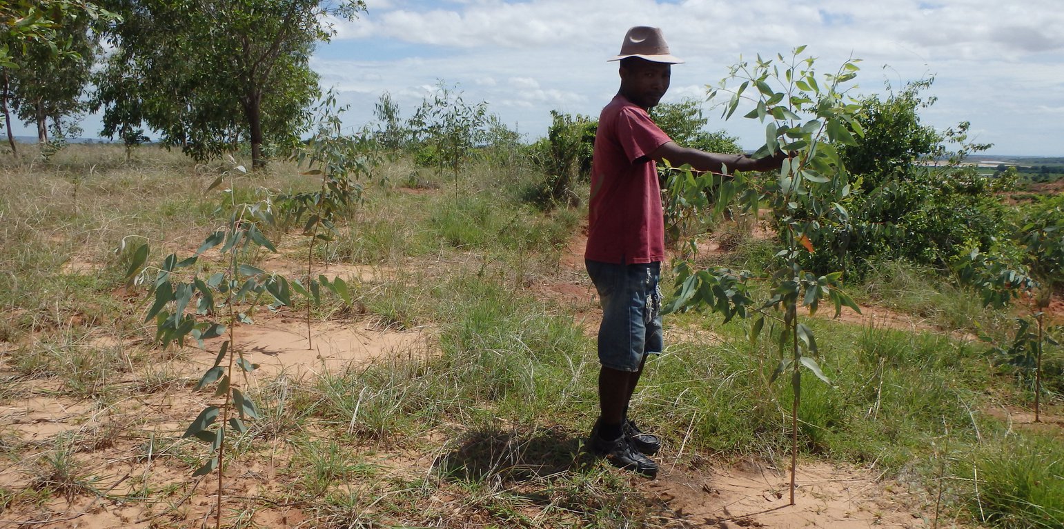
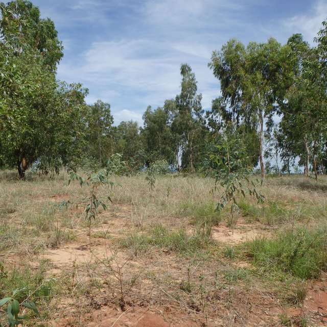
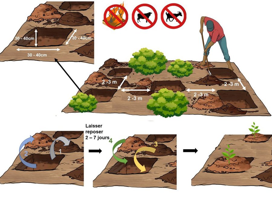
Crop exclosures are created on hilltops and steep slopes where cultivation is not recommended due to erosion risks. Passive crop exclusion comprises leaving a forested area uncultivated and encouraging the natural regeneration of the environment, while protecting it from fire and roaming livestock. Active exclosures, on the other hand, consists in supporting natural regeneration through restoration (enrichment and reforestation). When applying this technology, preference should be given to indigenous species (Harungana madagascariensis, Albizia lebbeck, etc.) over fast-growing species (Eucalyptus spp, Acacia spp) in order to maintain the biological diversity of the environment.
The various stages involved in establishing either passive or active crop exclosures are as follows:
- organisation of a general information meeting to raise awareness and canvas the concerns of the surrounding population;
- participatory delineation of the area to be protected (local authorities, owners and users concerned, etc.);
- creation of a management committee;
- preparation of a crop exclusion plans;
- public consultation and validation of the projects;
- formalization in the Fokontany and commune;
- implementation.

The development of surrounding areas and the installation of fascines (vegetative checkdams) to control gullying may also be incorporated into the clearing process, as per the agreed-upon local arrangement. Crop exclusion helps downstream areas from silting up, preserves soil fertility and regenerates degraded lands. It also improves infiltration and reduces erosion and soil loss.
The branches of regenerated trees can be sustainably harvested according to specific needs, such as fodder, wood, or organic matter for mulching purposes. Additionally, non-wood products can be gathered on these plots, including honey, medicinal plants, and species used for traditional knowledge-based or "ady gasy" products.

Location

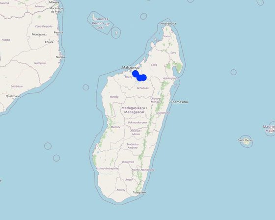
Location: Tsaramandroso, Antanambao Andranolava, Marovoay Banlieue, Manerinerina, Boeny, Madagascar

No. of Technology sites analysed: 2-10 sites

Geo-reference of selected sites
  • 46.69519, -16.02828
  • 47.30883, -16.31026
  • 47.3111, -16.31407
  • 47.0243, -16.3371
  • 46.68815, -15.99648

Spread of the Technology: evenly spread over an area (approx. < 0.1 km2 (10 ha))

In a permanently protected area?: No

Date of implementation: 2020; less than 10 years ago (recently)

Type of introduction
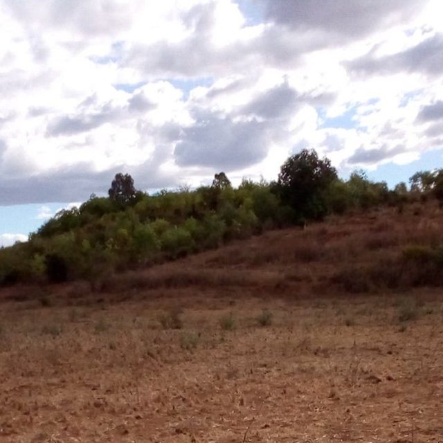
Exclosure of a very fragile area above cropland (Claude Chabaud)
Active enclosure (Felana Nantenaina Ramalason)

Classification of the Technology

Main purpose
  • improve production
  • reduce, prevent, restore land degradation
  • conserve ecosystem
  • protect a watershed/ downstream areas – in combination with other Technologies
  • preserve/ improve biodiversity
  • reduce risk of disasters
  • adapt to climate change/ extremes and its impacts
  • mitigate climate change and its impacts
  • create beneficial economic impact
  • create beneficial social impact
Land use
Land use mixed within the same land unit: No

  • Forest/ woodlands
    • Tree plantation, afforestation: tropical shrubland plantation - Eucalyptus spp., tropical shrubland plantation - broadleaf, Eucalyptus, Acacia, Albizia lebbeck. Varieties: Monoculture exotic variety, Mixed varieties
    Tree types (deciduous): n.a.
    Products and services: Timber, Fuelwood
  • Unproductive land - Specify: Lands where cultivation is impossible or poses a threat to downstream crops

Water supply
  • rainfed
  • mixed rainfed-irrigated
  • full irrigation

Purpose related to land degradation
  • prevent land degradation
  • reduce land degradation
  • restore/ rehabilitate severely degraded land
  • adapt to land degradation
  • not applicable
Degradation addressed
  • soil erosion by water - Wt: loss of topsoil/ surface erosion, Wg: gully erosion/ gullying
  • biological degradation - Bc: reduction of vegetation cover, Bh: loss of habitats, Bq: quantity/ biomass decline, Bs: quality and species composition/ diversity decline, Bl: loss of soil life
SLM group
  • forest plantation management
  • improved ground/ vegetation cover
  • integrated soil fertility management
SLM measures
  • vegetative measures - V1: Tree and shrub cover
  • management measures - M1: Change of land use type

Technical drawing

Technical specifications
Exclosures primarily serve as conservation zones, and their success relies heavily on addressing the concerns of the local population and land users. Collaboration among stakeholders is essential to reach an agreement that is accepted and respected, encompassing aspects like the designation of conservation areas, delineation of exclosure area, and protection of the area from potential threats such as bushfires and livestock roaming.
Where enrichment is necessary (active exclosure), the following technical specifications should be considered:
- Holes with dimensions of 30 to 40 cm in length and width, and a depth of 30 to 40 cm.
Staggered placement of holes at intervals of 2 to 3 meters.
- A clear separation between the top and bottom layers of the hole. After excavation, the hole is left open for 2 to 7 days before the soil is reinstated. The initial top layer is placed at the bottom of the hole, while the initial bottom layer is positioned on the surface.
- Planting seedlings into the ground and covering them with dry plant material to retain moisture at the crown of the seedlings;
- Indications prohibiting grazing and the passage of fire, along with the establishment of firebreaks.
Author: GIZ ProSoil Madagascar

Establishment and maintenance: activities, inputs and costs

Calculation of inputs and costs
  • Costs are calculated: per Technology area (size and area unit: 1 hectare)
  • Currency used for cost calculation: Ariary
  • Exchange rate (to USD): 1 USD = 4300.0 Ariary
  • Average wage cost of hired labour per day: 5000
Most important factors affecting the costs
n.a.
Establishment activities
  1. Delineate the exclosure area (Timing/ frequency: None)
  2. Draw up a development plan with the local authorities (Fokontany) and landowners concerned (Timing/ frequency: January-March)
  3. Establish a management committee for mass outreach sessions (Timing/ frequency: No later than 1 week after harvesting)
  4. Implement the local convention (Timing/ frequency: None)
  5. Create a firewall (Timing/ frequency: None)
  6. Install signposts (Timing/ frequency: None)
  7. Plan the location of the nurseries (Timing/ frequency: Before the rainy season)
  8. Plant nursery seedlings (Timing/ frequency: Rainy season)
Establishment inputs and costs (per 1 hectare)
Specify input Unit Quantity Costs per Unit (Ariary) Total costs per input (Ariary) % of costs borne by land users
Labour
Hole digging and seedling planting man-days 6.0 5000.0 30000.0 100.0
Equipment
Seedlings number 100.0 700.0 70000.0
Total costs for establishment of the Technology 100'000.0
Total costs for establishment of the Technology in USD 23.26
Maintenance activities
  1. Weeding out the firewall area (Timing/ frequency: Before the rainy season)
  2. Protection against cattle grazing (optional) (Timing/ frequency: All year round)
  3. Reseeding (Timing/ frequency: The rainy season for the following year)
Maintenance inputs and costs (per 1 hectare)
Specify input Unit Quantity Costs per Unit (Ariary) Total costs per input (Ariary) % of costs borne by land users
Labour
Creation and maintenance of a firebreak man-days 26.0 5000.0 130000.0 100.0
Pruning man-days 22.0 10000.0 220000.0 100.0
Total costs for maintenance of the Technology 350'000.0
Total costs for maintenance of the Technology in USD 81.4

Natural environment

Average annual rainfall
  • < 250 mm
  • 251-500 mm
  • 501-750 mm
  • 751-1,000 mm
  • 1,001-1,500 mm
  • 1,501-2,000 mm
  • 2,001-3,000 mm
  • 3,001-4,000 mm
  • > 4,000 mm
Agro-climatic zone
  • humid
  • sub-humid
  • semi-arid
  • arid
Specifications on climate
Average annual rainfall in mm: 1400.0
Slope
  • flat (0-2%)
  • gentle (3-5%)
  • moderate (6-10%)
  • rolling (11-15%)
  • hilly (16-30%)
  • steep (31-60%)
  • very steep (>60%)
Landforms
  • plateau/plains
  • ridges
  • mountain slopes
  • hill slopes
  • footslopes
  • valley floors
Altitude
  • 0-100 m a.s.l.
  • 101-500 m a.s.l.
  • 501-1,000 m a.s.l.
  • 1,001-1,500 m a.s.l.
  • 1,501-2,000 m a.s.l.
  • 2,001-2,500 m a.s.l.
  • 2,501-3,000 m a.s.l.
  • 3,001-4,000 m a.s.l.
  • > 4,000 m a.s.l.
Technology is applied in
  • convex situations
  • concave situations
  • not relevant
Soil depth
  • very shallow (0-20 cm)
  • shallow (21-50 cm)
  • moderately deep (51-80 cm)
  • deep (81-120 cm)
  • very deep (> 120 cm)
Soil texture (topsoil)
  • coarse/ light (sandy)
  • medium (loamy, silty)
  • fine/ heavy (clay)
Soil texture (> 20 cm below surface)
  • coarse/ light (sandy)
  • medium (loamy, silty)
  • fine/ heavy (clay)
Topsoil organic matter content
  • high (>3%)
  • medium (1-3%)
  • low (<1%)
Groundwater table
  • on surface
  • < 5 m
  • 5-50 m
  • > 50 m
Availability of surface water
  • excess
  • good
  • medium
  • poor/ none
Water quality (untreated)
  • good drinking water
  • poor drinking water (treatment required)
  • for agricultural use only (irrigation)
  • unusable
Water quality refers to: ground water
Is salinity a problem?
  • Yes
  • No

Occurrence of flooding
  • Yes
  • No
Species diversity
  • high
  • medium
  • low
Habitat diversity
  • high
  • medium
  • low

Characteristics of land users applying the Technology

Market orientation
  • subsistence (self-supply)
  • mixed (subsistence/ commercial)
  • commercial/ market
Off-farm income
  • less than 10% of all income
  • 10-50% of all income
  • > 50% of all income
Relative level of wealth
  • very poor
  • poor
  • average
  • rich
  • very rich
Level of mechanization
  • manual work
  • animal traction
  • mechanized/ motorized
Sedentary or nomadic
  • Sedentary
  • Semi-nomadic
  • Nomadic
Individuals or groups
  • individual/ household
  • groups/ community
  • cooperative
  • employee (company, government)
Gender
  • women
  • men
Age
  • children
  • youth
  • middle-aged
  • elderly
Area used per household
  • < 0.5 ha
  • 0.5-1 ha
  • 1-2 ha
  • 2-5 ha
  • 5-15 ha
  • 15-50 ha
  • 50-100 ha
  • 100-500 ha
  • 500-1,000 ha
  • 1,000-10,000 ha
  • > 10,000 ha
Scale
  • small-scale
  • medium-scale
  • large-scale
Land ownership
  • state
  • company
  • communal/ village
  • group
  • individual, not titled
  • individual, titled
Land use rights
  • open access (unorganized)
  • communal (organized)
  • leased
  • individual
Water use rights
  • open access (unorganized)
  • communal (organized)
  • leased
  • individual
Access to services and infrastructure
health

poor
good
education

poor
good
technical assistance

poor
good
employment (e.g. off-farm)

poor
good
markets

poor
good
energy

poor
good
roads and transport

poor
good
drinking water and sanitation

poor
good
financial services

poor
good

Impacts

Socio-economic impacts
wood production
decreased
increased

Socio-cultural impacts
food security/ self-sufficiency
reduced
improved

Ecological impacts
surface runoff
increased
decreased

soil moisture
decreased
increased

soil loss
increased
decreased

Off-site impacts
downstream siltation
increased
decreased

damage on neighbours' fields
increased
reduced

Cost-benefit analysis

Benefits compared with establishment costs
Short-term returns
very negative
very positive

Long-term returns
very negative
very positive

Benefits compared with maintenance costs
Short-term returns
very negative
very positive

Long-term returns
very negative
very positive

Climate change

Gradual climate change
annual rainfall decrease

not well at all
very well

Adoption and adaptation

Percentage of land users in the area who have adopted the Technology
  • single cases/ experimental
  • 1-10%
  • 11-50%
  • > 50%
Of all those who have adopted the Technology, how many have done so without receiving material incentives?
  • 0-10%
  • 11-50%
  • 51-90%
  • 91-100%
Has the Technology been modified recently to adapt to changing conditions?
  • Yes
  • No
To which changing conditions?
  • climatic change/ extremes
  • changing markets
  • labour availability (e.g. due to migration)

Conclusions and lessons learnt

Strengths: land user's view
  • Restoration of soil fertility
  • Production on infertile lands
  • Protection of downstream farmland from silting up
  • Wood production
Strengths: compiler’s or other key resource person’s view
Weaknesses/ disadvantages/ risks: land user's viewhow to overcome
  • Heavy workload and high expenses in the first year
  • Livestock grazing in the protected area Monitoring of the exclosure area
Weaknesses/ disadvantages/ risks: compiler’s or other key resource person’s viewhow to overcome

References

Compiler
  • Harifidy RAKOTO RATSIMBA
Editors
  • Felana Nantenaina RAMALASON
  • Dimby RAHERINJATOVOARISON
  • Siagbé Golli
  • Tahiry Ravivonandrasana
  • Natacha Rabeary
  • Tabitha Nekesa
  • Ahmadou Gaye
Reviewer
  • William Critchley
  • Rima Mekdaschi Studer
Date of documentation: Oct. 24, 2022
Last update: April 12, 2024
Resource persons
Full description in the WOCAT database
Linked SLM data
Documentation was faciliated by
Institution Project
Key references
  • Région Boeny, 2016, "Schéma Régional d’Aménagement du Territoire de la Région Boeny": Boeny Region Hotel
  • Raharinaivo S., 2008, "Les techniques de correction des ravines et de stabilisations des Lavaka", tirés des acquis du PLAE Marovoay: PLAE Marovoay, https://wocatpedia.net/wiki/File:Solofo_Raharinaivo_(2008)_-_Les_techniques_de_Correction_des_ravines_et_de_Stabilisation_des_Lavaka_.pdf
  • GRET, 2015, "Pratiques agroécologiques et agroforestières en zone tropicale humide", Fiche N°20 Régénération naturelle assistée: GRET, https://gret.org/publication/pratiques-agroecologiques-et-agroforestieres-en-zone-tropicale-humide/
This work is licensed under Creative Commons Attribution-NonCommercial-ShareaAlike 4.0 International