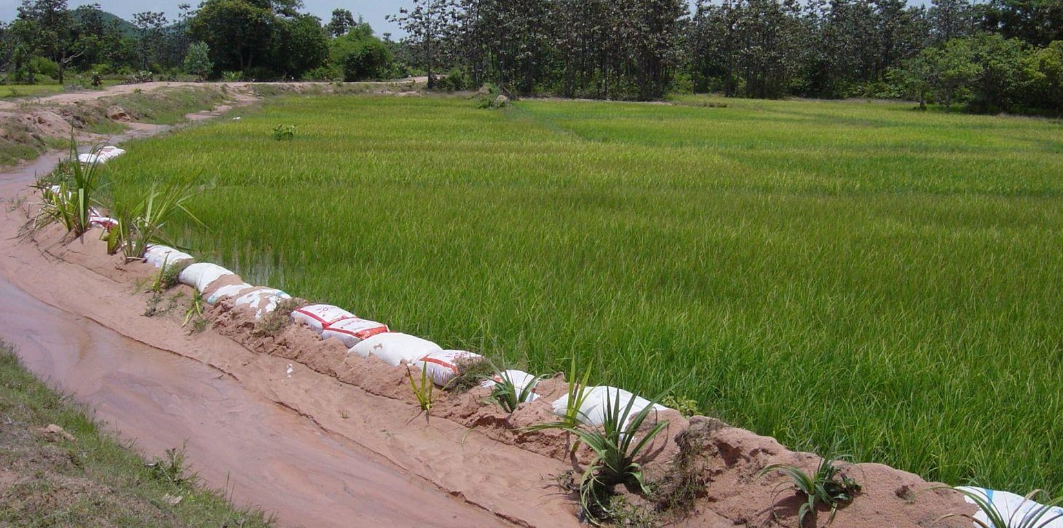
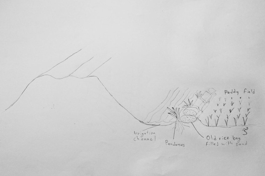
Recently stabilised dike with old rice bags and Pandanus, next to an irrigation channel and an eroding sand road. (Stefan Graf)

Stabilisation of irrigation channels in sandy soils with old rice bags and Pandanus plants (Cambodia)

បច្ចេកទេសដាក់បាវខ្សាច់ និងដាំដើមរំចេកតាមភ្លឺស្រែជាទំនប់ទប់ការហូរច្រោះ (Khmer)

Description

In sandy areas, old rice bags are filled with sand and piled up as dikes bordering irrigation channels, and Pandanus plants are used to stabilize them on the long term.

The paddy fields are surrounded by dikes and fed by local temporary streams and irrigation channels, as well as by rain. In sandy soils the dikes around the irrigation channels and fields cannot hold the water due to erosion. Old rice bags are filled with sand and piled up to form stable dikes on the short term, and Pandanus suckers are planted every 0.5 – 1 m to ensure a stability on the long term due to the root system.

The purpose of the dikes, stabilized for short and long term, is to ensure the flow of water to the paddy fields by reducing the riverbank erosion. It also helps to keep the water in the paddy fields. The Pandanus can be used to make mats and baskets, although this use diminishes due to the low cost of plastic. After a few years, the Pandanus on the dike is tall and spiky enough to fence off cattle and protect the rice from grazing.

To stabilize 50 m of dike, around 100 old rice bags are filled with sand and piled up on a height of 2 bags. Pandanus suckers are planted on the water side, between the bags, and sand is used to cover the plants and bags. Poles and sticks are used to stabilize the bags and plants until the root system is established. This is done in the beginning of the rainy season to ensure the growth of the sucker. In the first year, after each rain the eroded sand has to be added back to the dike. After the establishment phase, from the second year on, the Pandanus have to be cut back as they grow quickly and can grow tall.

The analysed area is flat (slope < 2%), with a tropical climate (dry season from November to May and wet season from June to October), and the soils are mostly sandy or loamy. The soil has a low fertility, contains little organic matter, and acidifies. The area has been deforested a long time ago, and the groundwater table is rather high (1-2 m during the dry season, on the surface during wet season).
Due to climate change, farmers notice more erratic rainfall, temperature rises and more recurrent droughts. Rice is the predominant crop grown in the area, since it serves as staple food (mix subsistence and commercial activities). Cattle are usually grazing on the fields after the harvest, without much control. Thus the cattle grazes too often and too much on the same spot, leading to degradation.
The increasing migration rate (the young generation leaves the villages to work in the cities, garment industry or abroad) results in a decrease of available labour force in the area which has detrimental effects on the agricultural activities. Furthermore, the civil war in the 1970s (Khmer Rouge) led to the loss of agricultural knowledge. Several NGOs are trying to re-establish the knowledge.

Location

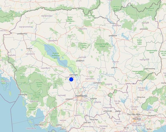
Location: Chrey Bak/Rolea Pha’ear, Kampong Chhnang, Cambodia

No. of Technology sites analysed:

Geo-reference of selected sites
  • 104.5907, 12.11291

Spread of the Technology: evenly spread over an area (approx. 1-10 km2)

In a permanently protected area?:

Date of implementation: more than 50 years ago (traditional)

Type of introduction
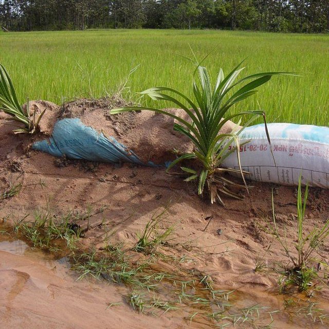
Pandanus suckers growing between rice bags (Stefan Graf)

Classification of the Technology

Main purpose
  • improve production
  • reduce, prevent, restore land degradation
  • conserve ecosystem
  • protect a watershed/ downstream areas – in combination with other Technologies
  • preserve/ improve biodiversity
  • reduce risk of disasters
  • adapt to climate change/ extremes and its impacts
  • mitigate climate change and its impacts
  • create beneficial economic impact
  • create beneficial social impact
Land use

  • Cropland
    • Annual cropping: cereals - rice (wetland)
    Number of growing seasons per year: 1
  • Waterways, waterbodies, wetlands -
Water supply
  • rainfed
  • mixed rainfed-irrigated
  • full irrigation

Purpose related to land degradation
  • prevent land degradation
  • reduce land degradation
  • restore/ rehabilitate severely degraded land
  • adapt to land degradation
  • not applicable
Degradation addressed
  • soil erosion by water - Wr: riverbank erosion
  • water degradation - Ha: aridification
SLM group
  • irrigation management (incl. water supply, drainage)
  • water diversion and drainage
  • surface water management (spring, river, lakes, sea)
SLM measures
  • vegetative measures - V1: Tree and shrub cover
  • structural measures - S3: Graded ditches, channels, waterways

Technical drawing

Technical specifications
Next to a road, (left) there is an irrigation channel in sandy soil. To prevent the little dam next to the rice field (right) from eroding, old rice bags are filled with sand and piled up. Between the rice bags, Pandanus suckers are planted. Sometimes they are also used to stabilise roadsides (not shown in this picture).
Kampong Chhnang
Date: 2014

Technical knowledge required for field staff / advisors: low
Technical knowledge required for land users: low
Main technical functions: stabilisation of soil (eg by tree roots against land slides), water harvesting / increase water supply, sediment retention / trapping, sediment harvesting

Vegetative measure: On dikes, allong irrigation channels
Vegetative material: T : trees / shrubs
Vertical interval within rows / strips / blocks (m): 0.5 - 1 m
Vegetative measure: Vegetative material: T : trees / shrubs
Trees/ shrubs species: Pandanus grown from suckers

Bund/ bank: graded
Height of bunds/banks/others (m): 0.3
Width of bunds/banks/others (m): 0.75

Construction material (other): Sand and sandbags
Vegetation is used for stabilisation of structures.
Author: Stefan Graf, Switzerland

Establishment and maintenance: activities, inputs and costs

Calculation of inputs and costs
  • Costs are calculated:
  • Currency used for cost calculation: Riels
  • Exchange rate (to USD): 1 USD = 4000.0 Riels
  • Average wage cost of hired labour per day: 5.00
Most important factors affecting the costs
The labour is the most costly part in this technology. Through the use of old rice bags filled with sand the costs are already reduced.
Establishment activities
  1. Fill the old rice bags with sand, pile them up, stabilize with sticks and add more sand after each rain, till the root system of the Pandanus plants have established (1 year) (Timing/ frequency: Beginning of wet season (Jun/Jul))
  2. Plant the Pandanus suckers between the bags (Timing/ frequency: beginning of wet season (June/July))
Establishment inputs and costs
Specify input Unit Quantity Costs per Unit (Riels) Total costs per input (Riels) % of costs borne by land users
Fertilizers and biocides
Construction of biodigester 1.0 400.0 400.0 50.0
Total costs for establishment of the Technology 400.0
Total costs for establishment of the Technology in USD 0.1
Maintenance activities
  1. Maintain the dikes (Timing/ frequency: every rainy season)
  2. Cut back the Pandanus plants (Timing/ frequency: Once a year, before planting rice)
Maintenance inputs and costs
Specify input Unit Quantity Costs per Unit (Riels) Total costs per input (Riels) % of costs borne by land users
Labour
labour 1.0 121.5 121.5 100.0
Total costs for maintenance of the Technology 121.5
Total costs for maintenance of the Technology in USD 0.03

Natural environment

Average annual rainfall
  • < 250 mm
  • 251-500 mm
  • 501-750 mm
  • 751-1,000 mm
  • 1,001-1,500 mm
  • 1,501-2,000 mm
  • 2,001-3,000 mm
  • 3,001-4,000 mm
  • > 4,000 mm
Agro-climatic zone
  • humid
  • sub-humid
  • semi-arid
  • arid
Specifications on climate
1486.45 mm 2013 in Kampong Chhnang
Thermal climate class: tropics. 27° to 35°C
Slope
  • flat (0-2%)
  • gentle (3-5%)
  • moderate (6-10%)
  • rolling (11-15%)
  • hilly (16-30%)
  • steep (31-60%)
  • very steep (>60%)
Landforms
  • plateau/plains
  • ridges
  • mountain slopes
  • hill slopes
  • footslopes
  • valley floors
Altitude
  • 0-100 m a.s.l.
  • 101-500 m a.s.l.
  • 501-1,000 m a.s.l.
  • 1,001-1,500 m a.s.l.
  • 1,501-2,000 m a.s.l.
  • 2,001-2,500 m a.s.l.
  • 2,501-3,000 m a.s.l.
  • 3,001-4,000 m a.s.l.
  • > 4,000 m a.s.l.
Technology is applied in
  • convex situations
  • concave situations
  • not relevant
Soil depth
  • very shallow (0-20 cm)
  • shallow (21-50 cm)
  • moderately deep (51-80 cm)
  • deep (81-120 cm)
  • very deep (> 120 cm)
Soil texture (topsoil)
  • coarse/ light (sandy)
  • medium (loamy, silty)
  • fine/ heavy (clay)
Soil texture (> 20 cm below surface)
  • coarse/ light (sandy)
  • medium (loamy, silty)
  • fine/ heavy (clay)
Topsoil organic matter content
  • high (>3%)
  • medium (1-3%)
  • low (<1%)
Groundwater table
  • on surface
  • < 5 m
  • 5-50 m
  • > 50 m
Availability of surface water
  • excess
  • good
  • medium
  • poor/ none
Water quality (untreated)
  • good drinking water
  • poor drinking water (treatment required)
  • for agricultural use only (irrigation)
  • unusable
Water quality refers to:
Is salinity a problem?
  • Yes
  • No

Occurrence of flooding
  • Yes
  • No
Species diversity
  • high
  • medium
  • low
Habitat diversity
  • high
  • medium
  • low

Characteristics of land users applying the Technology

Market orientation
  • subsistence (self-supply)
  • mixed (subsistence/ commercial)
  • commercial/ market
Off-farm income
  • less than 10% of all income
  • 10-50% of all income
  • > 50% of all income
Relative level of wealth
  • very poor
  • poor
  • average
  • rich
  • very rich
Level of mechanization
  • manual work
  • animal traction
  • mechanized/ motorized
Sedentary or nomadic
  • Sedentary
  • Semi-nomadic
  • Nomadic
Individuals or groups
  • individual/ household
  • groups/ community
  • cooperative
  • employee (company, government)
Gender
  • women
  • men
Age
  • children
  • youth
  • middle-aged
  • elderly
Area used per household
  • < 0.5 ha
  • 0.5-1 ha
  • 1-2 ha
  • 2-5 ha
  • 5-15 ha
  • 15-50 ha
  • 50-100 ha
  • 100-500 ha
  • 500-1,000 ha
  • 1,000-10,000 ha
  • > 10,000 ha
Scale
  • small-scale
  • medium-scale
  • large-scale
Land ownership
  • state
  • company
  • communal/ village
  • group
  • individual, not titled
  • individual, titled
Land use rights
  • open access (unorganized)
  • communal (organized)
  • leased
  • individual
Water use rights
  • open access (unorganized)
  • communal (organized)
  • leased
  • individual
Access to services and infrastructure
health

poor
x
good
education

poor
x
good
technical assistance

poor
x
good
employment (e.g. off-farm)

poor
x
good
markets

poor
x
good
energy

poor
x
good
roads and transport

poor
x
good
drinking water and sanitation

poor
x
good
financial services

poor
x
good

Impacts

Socio-economic impacts
Crop production
decreased
x
increased


Dried residues are put in the garden (cucumber, pumpkin, watermelon) which increases nutrient availability.

fodder production
decreased
x
increased

risk of production failure
increased
x
decreased

production area (new land under cultivation/ use)
decreased
x
increased

energy generation (e.g. hydro, bio)
decreased
x
increased


Before the installation of the biogas system, the land user bought firewood.

expenses on agricultural inputs
increased
x
decreased


He saves 50 $ on chemical fertilizer per year.

farm income
decreased
x
increased

diversity of income sources
decreased
x
increased

workload
increased
x
decreased

Socio-cultural impacts
food security/ self-sufficiency
reduced
x
improved

health situation
worsened
x
improved


No smoke from open fire.

contribution to human well-being
decreased
x
increased


On the long term livelihood is improved, because he saves over 60 $ per year in firewood and battery charging for light, as well as 50 $ for chemical fertilizer.

Ecological impacts
water quantity
decreased
x
increased

water quality
decreased
x
increased


Pollution of groundwater due to washing out of nutrients.

soil moisture
decreased
x
increased

soil loss
increased
x
decreased

soil organic matter/ below ground C
decreased
x
increased


Most of the carbon is transformed into methane, not available as organic matter.

pest/ disease control
decreased
x
increased

Reduced weed seeds
decreased
x
increased


Compost usually not completely decomposed, as well as raw manure, contain lots of weed seeds.

Off-site impacts
groundwater/ river pollution
increased
x
reduced


Sludge is left to dry outside, nutrients washed out into groundwater. Not measurable.

Cost-benefit analysis

Benefits compared with establishment costs
Short-term returns
very negative
x
very positive

Long-term returns
very negative
x
very positive

Benefits compared with maintenance costs
Short-term returns
very negative
x
very positive

Long-term returns
very negative
x
very positive

Difficult question for farmers.

Climate change

Gradual climate change
annual temperature increase

not well at all
x
very well
Climate-related extremes (disasters)
local rainstorm

not well at all
very well
Answer: not known
local windstorm

not well at all
x
very well
drought

not well at all
x
very well
general (river) flood

not well at all
very well
Answer: not known
Other climate-related consequences
reduced growing period

not well at all
x
very well

Adoption and adaptation

Percentage of land users in the area who have adopted the Technology
  • single cases/ experimental
  • 1-10%
  • 11-50%
  • > 50%
Of all those who have adopted the Technology, how many have done so without receiving material incentives?
  • 0-10%
  • 11-50%
  • 51-90%
  • 91-100%
Has the Technology been modified recently to adapt to changing conditions?
  • Yes
  • No
To which changing conditions?
  • climatic change/ extremes
  • changing markets
  • labour availability (e.g. due to migration)

Conclusions and lessons learnt

Strengths: land user's view
  • The Pandanus leaves are used for baskets and mats.
  • The water is stored in the rice fields. Without stabilisation, the berms would not hold any water at all in sandy conditions.
  • Cattle is fenced off the rice fields through tall and thick (old) Pandanus plants growing on the dikes.
  • The irrigation channels are not eroded, water keeps flowing
Strengths: compiler’s or other key resource person’s view
Weaknesses/ disadvantages/ risks: land user's viewhow to overcome
  • The Pandanus grow too quickly and too tall, and require workload which is not available. Select slow growing species or individuals.
  • Rodents use the Pandanus as niches. Protect natural predators (snakes), or hunt/trap the rodents.
Weaknesses/ disadvantages/ risks: compiler’s or other key resource person’s viewhow to overcome
  • the plastic from the rice bags disintegrates with time and causes river pollution. Use organic material (e.g. rice bags) to stabilize the dike for the first year.

References

Compiler
  • Stefan Graf
Editors
Reviewer
  • Deborah Niggli
  • Alexandra Gavilano
  • Rima Mekdaschi Studer
Date of documentation: Nov. 6, 2014
Last update: Feb. 7, 2024
Resource persons
Full description in the WOCAT database
Linked SLM data
Documentation was faciliated by
Institution Project
Key references
  • NBP National Biodigester Program: www.nbp.org.kh
  • Lam et al. 2009. Domestic Biogas Compact Course. University of Oldenburg.: http://www.nbp.org.kh/publication/study_report/2_domestic_biogas%20.pdf
  • Gurung. 2009. Review of Literature on Effects of Slurry Use on Crop production. The Biogas Support Program:
This work is licensed under Creative Commons Attribution-NonCommercial-ShareaAlike 4.0 International