Cane and Bamboo Plantation to Sustain Raw Materials
(Bhutan)
Ba Dang Pa Tshar Zuk Chong Bae Dhi Thoen Koed Yuen Ten Zho Ni (སྦ་དང་སྤ་ཚར་འཛུགས་སྐྱོང་འབད་དེ་ཐོན་སྐྱེད་ཡུན་བརྟན་བཟོ་ནི།)
Description
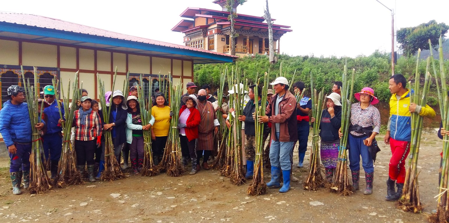
Cane and bamboo plantations are managed by land users and indigenous communities to sustain these valuable raw materials for making handicraft items. Tsharzo (bamboo craft), is one of the main sources of income for land users. Tsharzo makes use of cane and bamboo to weave products such as backpacks, baskets (for winnowing, for carrying fodder, fruits, shoots, etc.), and mats. These plantations are effective in conserving land and water.
Tsharzo (bamboo craft), is one of the main sources of income, besides agriculture, for the land users of the Monpa community of Jangbi, Wangling, and Phrumzur in Trongsa. Tsharzo makes use of cane (“rattan”: Calamus spp.) and bamboo to weave products such as orongbhazib (backpacks), lapchu (hand baskets), chungchu (baskets), bechab (winnowing baskets), tsew (baskets to carry fodder, fruits, shoots etc.) and pari (mats). The technology of maintaining bamboo and cane plantations has been adopted by the land users to ensure a sustainable harvest of natural raw materials and to maintain germplasm for bamboo and cane. This helps to uphold ancestral arts and crafts skills, and to improve livelihoods.
Jangbi chiwog has 59 households (HH). The land users are members of Monpa Selwai Yoezer Tshogpa, a Community Forest Management Group which was formed to sustainably manage bamboo and cane resources, to preserve and promote age-old cane and bamboo handicraft skills and increase household income. The group is one of the most successful in promoting Tsharzo in the country. The group was formed under the United Nations Development Programme (UNDP) on 14 April 2000, and officially came into play in 2007, upon drafting bylaws. The bylaws were revised after the need for further improvement in the year 2018. The group received initial support from UNDP and Bhutan Orchids, a non-governmental organization (NGO). The government has given a total of 45 acres (18 ha) of land to the land users of Jangbi Chiwog to plant bamboo and cane. Out of the total, 15 acres (6 ha) are collectively managed as a nursery. About 10 acres (4 ha) are managed by each village as a plantation. The land users have planted three varieties of bamboo on the land.
The benefits of the technology include the establishment of dedicated germplasm for bamboo and cane, sustainable harvest of natural raw materials, conservation and promotion of ancestral arts and crafts skills, social cohesion through group formation, and employment opportunities.
Bamboo and cane plantations play a great role in preventing soil degradation. Bamboo and cane have extensive root systems that help prevent erosion, stabilize soil, and reduce landslide risks. They are excellent for revegetation as they quickly establish themselves. Bamboo is also an efficient carbon sink, absorbing significant amounts of carbon dioxide from the atmosphere. This helps mitigate climate change by reducing greenhouse gas concentrations. Bamboo and cane provide habitats for various organisms thereby increasing biodiversity. Products made from bamboo and cane are biodegradable, minimizing any potential environmental impact.
Location
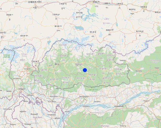
Location: Jangbi, Wangling and Phrumzur villages under Jangbi Chiwog, Langthel gewog, Trongsa Dzongkhag, Bhutan
No. of Technology sites analysed: single site
Geo-reference of selected sites
Spread of the Technology: evenly spread over an area (18.2 km²)
In a permanently protected area?: Yes
Date of implementation: 2000
Type of introduction
-
through land users' innovation
-
as part of a traditional system (> 50 years)
-
during experiments/ research
-
through projects/ external interventions
Bamboo planted in a farmer's field (Kuenzang Nima)
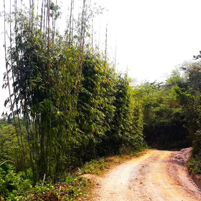
Bamboo planted along the farm roadside for stabilization and domestic use. (Haka Drukpa)
Classification of the Technology
Main purpose
-
improve production
-
reduce, prevent, restore land degradation
-
conserve ecosystem
-
protect a watershed/ downstream areas – in combination with other Technologies
-
preserve/ improve biodiversity
-
reduce risk of disasters
-
adapt to climate change/ extremes and its impacts
-
mitigate climate change and its impacts
-
create beneficial economic impact
-
create beneficial social impact
Land use
Land use mixed within the same land unit: No
Water supply
-
rainfed
-
mixed rainfed-irrigated
-
full irrigation
Purpose related to land degradation
-
prevent land degradation
-
reduce land degradation
-
restore/ rehabilitate severely degraded land
-
adapt to land degradation
-
not applicable
Degradation addressed
-
soil erosion by water - Wt: loss of topsoil/ surface erosion, Wg: gully erosion/ gullying, Wm: mass movements/ landslides
-
soil erosion by wind - Et: loss of topsoil
-
biological degradation - Bc: reduction of vegetation cover, Bq: quantity/ biomass decline
SLM group
-
natural and semi-natural forest management
-
forest plantation management
SLM measures
-
vegetative measures - V1: Tree and shrub cover
-
structural measures - S6: Walls, barriers, palisades, fences
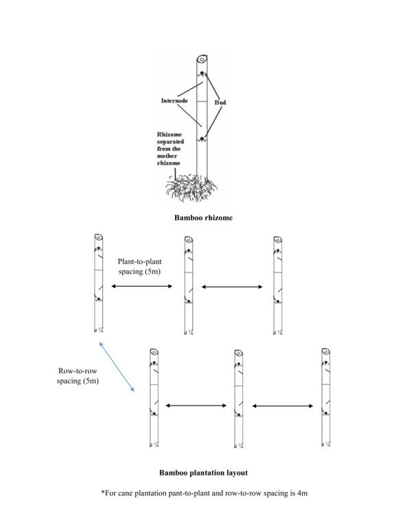
Technical drawing
Technical specifications
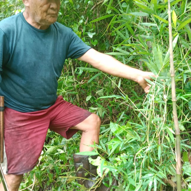
The bamboos thriving in the wild are documented in the community. They are an important source of raw materials for producing bamboo products.
Author: Tshering Yangzom
Establishment and maintenance: activities, inputs and costs
Calculation of inputs and costs
- Costs are calculated: per Technology area (size and area unit: 45 acres; conversion factor to one hectare: 1 ha = 45 acres = 18.2 ha)
- Currency used for cost calculation: Nu.
- Exchange rate (to USD): 1 USD = 82.0 Nu.
- Average wage cost of hired labour per day: n.a
Most important factors affecting the costs
n.a.
Establishment activities
-
Attempted to commercialize bamboo and cane products through market exploration (contract) by a few households. (Timing/ frequency: 2000)
-
Gewog and the Forest Office collaboratively explored funds to help the communities. (Timing/ frequency: 2000)
-
Funds sourced from UNDP. The land users were sensitized. (Timing/ frequency: 2000 (summer-during paddy season))
-
The land users were trained on plantations and product development. (Timing/ frequency: 2000)
-
Land users (12 of them) were taken on an exposure tour to India. (Timing/ frequency: 2000)
Total establishment costs (estimation)
2200000.0
Maintenance activities
n.a.
Total maintenance costs (estimation)
20000.0
Natural environment
Average annual rainfall
-
< 250 mm
-
251-500 mm
-
501-750 mm
-
751-1,000 mm
-
1,001-1,500 mm
-
1,501-2,000 mm
-
2,001-3,000 mm
-
3,001-4,000 mm
-
> 4,000 mm
Agro-climatic zone
-
humid
-
sub-humid
-
semi-arid
-
arid
Specifications on climate
The rain estimate has been derived based on the agro-ecological zone (AEZ) the area falls under. Bhutan is divided into six AEZs (source: https://www.fao.org/3/ad103e/AD103E02.htm).
The site is about 1500 masl. It falls under Dry-Subtropical Zone. Bhutan has six AEZs. The wet sub-tropical zone is from 150 to 600 m, followed by the humid sub-tropical zone from 600 to 1,200 m. The dry sub-tropical zone starts at 1,200 m and extends to 1,800 m, followed by the warm temperate zone, which reaches 2,600 m. The cool temperate zone lies between 2,600 and 3,600 m and, finally, the alpine zone between 3,600 m and 4,600 m.
https://www.fao.org/3/ad103e/AD103E02.htm
Slope
-
flat (0-2%)
-
gentle (3-5%)
-
moderate (6-10%)
-
rolling (11-15%)
-
hilly (16-30%)
-
steep (31-60%)
-
very steep (>60%)
Landforms
-
plateau/plains
-
ridges
-
mountain slopes
-
hill slopes
-
footslopes
-
valley floors
Altitude
-
0-100 m a.s.l.
-
101-500 m a.s.l.
-
501-1,000 m a.s.l.
-
1,001-1,500 m a.s.l.
-
1,501-2,000 m a.s.l.
-
2,001-2,500 m a.s.l.
-
2,501-3,000 m a.s.l.
-
3,001-4,000 m a.s.l.
-
> 4,000 m a.s.l.
Technology is applied in
-
convex situations
-
concave situations
-
not relevant
Soil depth
-
very shallow (0-20 cm)
-
shallow (21-50 cm)
-
moderately deep (51-80 cm)
-
deep (81-120 cm)
-
very deep (> 120 cm)
Soil texture (topsoil)
-
coarse/ light (sandy)
-
medium (loamy, silty)
-
fine/ heavy (clay)
Soil texture (> 20 cm below surface)
-
coarse/ light (sandy)
-
medium (loamy, silty)
-
fine/ heavy (clay)
Topsoil organic matter content
-
high (>3%)
-
medium (1-3%)
-
low (<1%)
Groundwater table
-
on surface
-
< 5 m
-
5-50 m
-
> 50 m
Availability of surface water
-
excess
-
good
-
medium
-
poor/ none
Water quality (untreated)
-
good drinking water
-
poor drinking water (treatment required)
-
for agricultural use only (irrigation)
-
unusable
Water quality refers to: surface water
Is salinity a problem?
Occurrence of flooding
Characteristics of land users applying the Technology
Market orientation
-
subsistence (self-supply)
-
mixed (subsistence/ commercial)
-
commercial/ market
Off-farm income
-
less than 10% of all income
-
10-50% of all income
-
> 50% of all income
Relative level of wealth
-
very poor
-
poor
-
average
-
rich
-
very rich
Level of mechanization
-
manual work
-
animal traction
-
mechanized/ motorized
Sedentary or nomadic
-
Sedentary
-
Semi-nomadic
-
Nomadic
Individuals or groups
-
individual/ household
-
groups/ community
-
cooperative
-
employee (company, government)
Age
-
children
-
youth
-
middle-aged
-
elderly
Area used per household
-
< 0.5 ha
-
0.5-1 ha
-
1-2 ha
-
2-5 ha
-
5-15 ha
-
15-50 ha
-
50-100 ha
-
100-500 ha
-
500-1,000 ha
-
1,000-10,000 ha
-
> 10,000 ha
Scale
-
small-scale
-
medium-scale
-
large-scale
Land ownership
-
state
-
company
-
communal/ village
-
group
-
individual, not titled
-
individual, titled
-
Family land
Land use rights
-
open access (unorganized)
-
communal (organized)
-
leased
-
individual
Water use rights
-
open access (unorganized)
-
communal (organized)
-
leased
-
individual
Access to services and infrastructure
employment (e.g. off-farm)
drinking water and sanitation
Impacts
Socio-economic impacts
non-wood forest production
Quantity before SLM: 50 - 60 products in a year
Quantity after SLM: 10 - 15 products in a year
The non-wood forest production has increased due to sustainable plantation, but the number of products developed using the raw materials has decreased. But again, the income has increased. In the earlier years, a household would earn about Nu.10000 by selling 50 - 60 products, whereas a household now earns a minimum of Nu. 25000 by selling 10 - 15 products due to higher prices of the products.
production area (new land under cultivation/ use)
Quantity before SLM: None
Quantity after SLM: 18.2 ha
With the initiation of bamboo and cane germplasm, the production area has increased and the source of raw materials for the community is sustained. Before the land users were given 18.2 ha by the government, the land users collected cane and bamboo from the forest to make products.
land management
The bamboo and cane plantations have prevented soil erosion and stabilized the lands.
diversity of income sources
The income earned from products sold in the market adds to the annual income of the family.
Socio-cultural impacts
food security/ self-sufficiency
The higher annual income generation from the sale of bamboo and cane products has assured food security in some ways.
health situation
Better income and diet have resulted in better health.
SLM/ land degradation knowledge
The role of plantations in mitigating land degradation is well-instilled in the land users. They now even carry out bamboo plantations along the peripheries of newly constructed roads to stabilize the soil faster.
conflict mitigation
There is equity in the harvest of raw materials.
situation of socially and economically disadvantaged groups (gender, age, status, ehtnicity etc.)
The land users have been able to improve their livelihood through sustainable management of bamboo and cane and the sale of the finished products.
Ecological impacts
vegetation cover
The vegetation cover has increased due to the plantation.
biomass/ above ground C
The biomass has increased due to the increase in vegetation cover.
Cost-benefit analysis
Benefits compared with establishment costs
Short-term returns
very negative
very positive
Long-term returns
very negative
very positive
Benefits compared with maintenance costs
Short-term returns
very negative
very positive
Long-term returns
very negative
very positive
Climate change
Gradual climate change
annual temperature increase
not well at all
very well
Climate-related extremes (disasters)
not well at all
very well
not well at all
very well
not well at all
very well
not well at all
very well
not well at all
very well
not well at all
very well
Adoption and adaptation
Percentage of land users in the area who have adopted the Technology
-
single cases/ experimental
-
1-10%
-
11-50%
-
> 50%
Of all those who have adopted the Technology, how many have done so without receiving material incentives?
-
0-10%
-
11-50%
-
51-90%
-
91-100%
Number of households and/ or area covered
59 HH are part of Monpa Selwai Yoezer Tshogpa
Has the Technology been modified recently to adapt to changing conditions?
To which changing conditions?
-
climatic change/ extremes
-
changing markets
-
labour availability (e.g. due to migration)
Conclusions and lessons learnt
Strengths: land user's view
-
Preserve and promote ancestral arts and crafts skills.
-
Maintain germplasm for bamboo and cane. The raw materials for future use are assured due to the establishment of a 45-acre germplasm.
-
Generate income through the sale of bamboo and cane products.
-
Sustainable harvest of natural raw materials
Strengths: compiler’s or other key resource person’s view
-
Higher vegetation cover.
-
Prevent land degradation (bamboo and cane have extensive root systems that help prevent erosion, stabilize soil, and reduce landslide risks).
-
Sustainable utilization of forest resources (bamboo and cane).
-
Diversify income sources of the land users.
-
Social cohesion through collaboration and coordination among the land users.
Weaknesses/ disadvantages/ risks: land user's viewhow to overcome
-
The identified germplasm area lacks suitable places for convenient plantations. The majority of the area is rugged terrain and steep.
Exclude the steep and rugged terrains. Explore and identify suitable and more convenient areas for plantation.
-
The wooden fencing poles surrounding the germplasm area are not durable (cannot withstand barbed wires for longer periods).
Replace the wooden fencing poles with steel posts or other durable materials.
-
No funds to scale up. For instance, the canes lost in the 2017 forest fire have not been re-generated like bamboo.
Additional funds are to be sought to scale up the plantation programs.
Weaknesses/ disadvantages/ risks: compiler’s or other key resource person’s viewhow to overcome
-
No funds to scale up.
Provision of funds by relevant stakeholders.
-
Risk of fire.
The Department of Forests and Park Services had initiated Interagency Forest Fire Coordination Group (IFFCG) at Dzongkhag and Gewog level to mitigate fire with involvement of Dzongkhag, Gewogs and relevant agencies. The IFFCG is headed by Dasho Dzongda and the Dzongkhag disaster management committee in coordination with relevant agency are responsible for mitigation and preventing the fire and provide necessary support to the affected individual or community. Several awareness programs and hands on training on fire mitigation and prevention was also provided to the communities by the Department of Forests and Park Services.
References
Reviewer
-
William Critchley
-
Rima Mekdaschi Studer
-
Joana Eichenberger
Date of documentation: July 17, 2023
Last update: May 30, 2024
Resource persons
-
Sonam - land user
-
Nagari - land user
-
Chencho - land user
-
Lethro - land user
Full description in the WOCAT database
Documentation was faciliated by
Institution
- National Soil Services Center, Department of Agric (National Soil Services Center, Department of Agric) - Bhutan
Project
- Strengthening national-level institutional and professional capacities of country Parties towards enhanced UNCCD monitoring and reporting – GEF 7 EA Umbrella II (GEF 7 UNCCD Enabling Activities_Umbrella II)
Links to relevant information which is available online