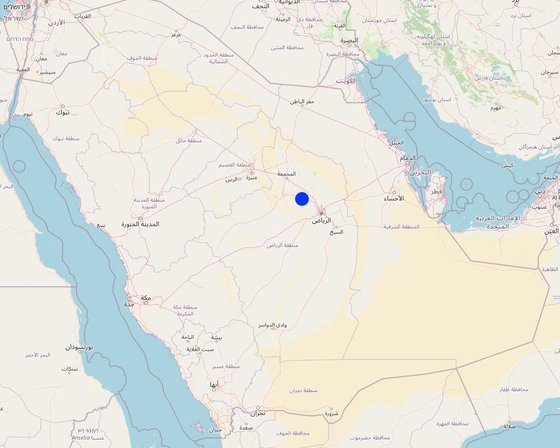
Plantation pits in the National Park (Eleonor Coker)

Plantation pits (Saudi Arabia)

Plantation pits

Description

Plantation pits are water harvesting structures which capture rainfall runoff for planting trees and shrubs. They can also be manually watered. Their size varies, but each plantation pit is approximately 2 metres x 1 metre wide and up to 1 metre deep.

Plantation pits are water harvesting structures which capture rainfall runoff for planting trees and shrubs. They can also be watered manually. The pits are dug within national parks managed by the National Centre for Vegetation Cover Development and Combating Desertification (NCVC). They may be located within wadis and sheyhib (small wadis) ranging from ten to several hundred metres in width, but also on high plateaux. Each plantation pit is rectangular, measuring 2m long, 1m wide, and up to 1m deep (depending on the depth of the soil). They are excavated by mechanical diggers. Pits are dug up to two years before planting, and they collect both runoff and the rich organic and mineral matter material carried in the runoff. After one year, many annual and even perennial plants have usually colonised the bottom of the pit. Trees and shrubs (including Acacia spp., Ziziphus spp. and Haxloylon spp.) are planting in the middle of the pit, without disturbing the existing vegetation as far as possible. These species attract bees, and beekeeping has been promoted alongside tree planting.
This water and nutrient harvesting technique is effective even in the very arid conditions – where rainfall may be less than 100 mm per year. However, some supplemental irrigation is needed, and each pit is watered, for example, around 7 times over the following year and a half, with a volume of water ranging from 20 to 100 litres each time per pit, depending on availability. Watering helps the plant to survive and the large quantity of water penetrates deep into the soil. As it moves downwards, it draws the roots downwards until they reach the water table. This is when watering can be stopped, often after 3 or 5 years. This is why the interval between watering is important, to effectively "pull the roots down" while leaving the plant enough water in the soil to survive. Although the costs are high, the results are generally very satisfactory in terms of planting and survival. The local impact is significant when there are enough pits per hectare, i.e. around 100 or more. Over the last five years one and a half million pits have been constructed. The technical design of the pits was formulated by Abdulla Al Eissa, the park manager, but FAO has been responsible for technical advising on planting operations. The activities are part funded by the NCVC, while local donors and volunteers contribute the remainder of the costs.
This activity is supported by the Food and Agriculture Organization of the United Nations (FAO), project: Strengthening MoEWA's Capacity to implement its Sustainable Rural Agricultural Development (SRAD) Programme (2019-2025) UTF/SAU/051/SAU.

Location

Location: Thadiq National Park, Riyadh Region (Province), Saudi Arabia

No. of Technology sites analysed: 10-100 sites

Geo-reference of selected sites
  • 45.94425, 25.17214

Spread of the Technology: evenly spread over an area (145.0 km²)

In a permanently protected area?: Yes

Date of implementation: 2019

Type of introduction
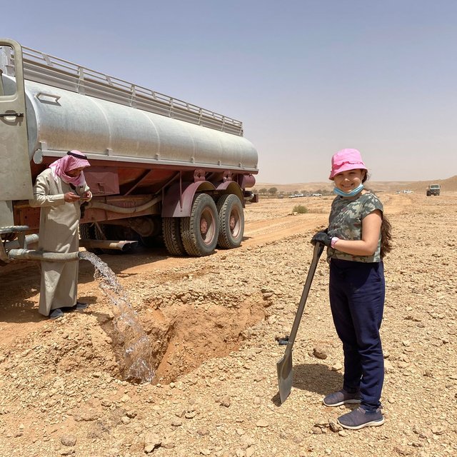
Plantation pits (Éric Lacroix)

Classification of the Technology

Main purpose
  • improve production
  • reduce, prevent, restore land degradation
  • conserve ecosystem
  • protect a watershed/ downstream areas – in combination with other Technologies
  • preserve/ improve biodiversity
  • reduce risk of disasters
  • adapt to climate change/ extremes and its impacts
  • mitigate climate change and its impacts
  • create beneficial economic impact
  • create beneficial social impact
Land use
Land use mixed within the same land unit: No

  • Forest/ woodlands
    • (Semi-)natural forests/ woodlands: subtropical dry forest natural vegetation. Management: Non-wood forest use
    • Tree plantation, afforestation: subtropical dry forest plantation, subtropical dry forest plantation - Broadleaf. Varieties: Mixed varieties
    Tree types (deciduous): Acacia species, Acacia tortilis, Balanites aegyptiaca, Ziziphus mauritiana
    Products and services: Nature conservation/ protection, Recreation/ tourism, Protection against natural hazards
Water supply
  • rainfed
  • mixed rainfed-irrigated
  • full irrigation

Purpose related to land degradation
  • prevent land degradation
  • reduce land degradation
  • restore/ rehabilitate severely degraded land
  • adapt to land degradation
  • not applicable
Degradation addressed
  • soil erosion by water - Wt: loss of topsoil/ surface erosion, Wg: gully erosion/ gullying, Wo: offsite degradation effects
  • physical soil deterioration - Pk: slaking and crusting, Pu: loss of bio-productive function due to other activities
  • biological degradation - Bc: reduction of vegetation cover, Bh: loss of habitats, Bq: quantity/ biomass decline, Bs: quality and species composition/ diversity decline, Bl: loss of soil life
  • water degradation - Ha: aridification, Hs: change in quantity of surface water, Hg: change in groundwater/aquifer level, Hp: decline of surface water quality, Hq: decline of groundwater quality
SLM group
  • natural and semi-natural forest management
  • water harvesting
  • beekeeping, aquaculture, poultry, rabbit farming, silkworm farming, etc.
SLM measures
  • structural measures - S4: Level ditches, pits, S7: Water harvesting/ supply/ irrigation equipment

Technical drawing

Technical specifications
Each pit is 2 m long, 1m wide, up to 1m deep, spacing from 3 to 10 meters between structures in curved lines, or 3 meters apart in clusters. Watering with 20 to 100 litres depending on the availability and price of water and cost of transportation and watering. 100 pits minimum per hectare (maximum 1100, which is rare in this environment). One to three seedlings (tree, shrub, plant) per pit. Watering for example 7 times in 1.5 to 2 years, depending on the soil humidity.
Author: Éric Lacroix,

Establishment and maintenance: activities, inputs and costs

Calculation of inputs and costs
  • Costs are calculated: per Technology area (size and area unit: hectare (with 100 pits))
  • Currency used for cost calculation: USD
  • Exchange rate (to USD): 1 USD = n.a
  • Average wage cost of hired labour per day: 50
Most important factors affecting the costs
When supported by local donors and villagers, costs are relatively low. When the administration covers the cost, contractors are brought in and that makes it more expensive
Establishment activities
  1. Identify the site. (Timing/ frequency: Dry season)
  2. Mark the pits with stakes (Timing/ frequency: Dry season)
  3. Dig the pits (Timing/ frequency: Dry season)
  4. Produce the seedlings in a nursery (Timing/ frequency: Dry season)
  5. Plant the seedlings (Timing/ frequency: Dry season)
  6. Watering the seedlings (and replacing the dead ones). (Timing/ frequency: Dry season)
  7. Checking the pits during the first rain. (Timing/ frequency: Rainy season)
  8. Checking the pits during or after floodings (Timing/ frequency: Floodings)
Establishment inputs and costs (per hectare (with 100 pits))
Specify input Unit Quantity Costs per Unit (USD) Total costs per input (USD) % of costs borne by land users
Labour
Technician 100.0
Worker 100.0
Equipment
Truck 100.0
Excavator 100.0
Plant material
100 seedlings per ha 100.0
Maintenance activities
  1. Checking the pits after the first rain. (Timing/ frequency: One time, after the first rain.)
  2. Checking the pits after the floodings. (Timing/ frequency: After the floodings.)
  3. Replace the seedlings when necessary: the watering truck driver get 5 seedlings everyday to replace dead plants. (Timing/ frequency: During watering.)
  4. Watering with a truck, 20 to 100 litres per pit = 2,000 to 10,000 litre per ha. (Timing/ frequency: 7 times in 1.5 year, during 3 to 5 years.)
Maintenance inputs and costs (per hectare (with 100 pits))
Specify input Unit Quantity Costs per Unit (USD) Total costs per input (USD) % of costs borne by land users
Plant material
30 seedlings per ha 1.0 100.0

Natural environment

Average annual rainfall
  • < 250 mm
  • 251-500 mm
  • 501-750 mm
  • 751-1,000 mm
  • 1,001-1,500 mm
  • 1,501-2,000 mm
  • 2,001-3,000 mm
  • 3,001-4,000 mm
  • > 4,000 mm
Agro-climatic zone
  • humid
  • sub-humid
  • semi-arid
  • arid
Specifications on climate
Average annual rainfall in mm: 71.0
Name of the meteorological station: Internet
Slope
  • flat (0-2%)
  • gentle (3-5%)
  • moderate (6-10%)
  • rolling (11-15%)
  • hilly (16-30%)
  • steep (31-60%)
  • very steep (>60%)
Landforms
  • plateau/plains
  • ridges
  • mountain slopes
  • hill slopes
  • footslopes
  • valley floors
Altitude
  • 0-100 m a.s.l.
  • 101-500 m a.s.l.
  • 501-1,000 m a.s.l.
  • 1,001-1,500 m a.s.l.
  • 1,501-2,000 m a.s.l.
  • 2,001-2,500 m a.s.l.
  • 2,501-3,000 m a.s.l.
  • 3,001-4,000 m a.s.l.
  • > 4,000 m a.s.l.
Technology is applied in
  • convex situations
  • concave situations
  • not relevant
Soil depth
  • very shallow (0-20 cm)
  • shallow (21-50 cm)
  • moderately deep (51-80 cm)
  • deep (81-120 cm)
  • very deep (> 120 cm)
Soil texture (topsoil)
  • coarse/ light (sandy)
  • medium (loamy, silty)
  • fine/ heavy (clay)
Soil texture (> 20 cm below surface)
  • coarse/ light (sandy)
  • medium (loamy, silty)
  • fine/ heavy (clay)
Topsoil organic matter content
  • high (>3%)
  • medium (1-3%)
  • low (<1%)
Groundwater table
  • on surface
  • < 5 m
  • 5-50 m
  • > 50 m
Availability of surface water
  • excess
  • good
  • medium
  • poor/ none
Water quality (untreated)
  • good drinking water
  • poor drinking water (treatment required)
  • for agricultural use only (irrigation)
  • unusable
Water quality refers to: ground water
Is salinity a problem?
  • Yes
  • No

Occurrence of flooding
  • Yes
  • No
Species diversity
  • high
  • medium
  • low
Habitat diversity
  • high
  • medium
  • low

Characteristics of land users applying the Technology

Market orientation
  • subsistence (self-supply)
  • mixed (subsistence/ commercial)
  • commercial/ market
Off-farm income
  • less than 10% of all income
  • 10-50% of all income
  • > 50% of all income
Relative level of wealth
  • very poor
  • poor
  • average
  • rich
  • very rich
Level of mechanization
  • manual work
  • animal traction
  • mechanized/ motorized
Sedentary or nomadic
  • Sedentary
  • Semi-nomadic
  • Nomadic
  • Tourists
Individuals or groups
  • individual/ household
  • groups/ community
  • cooperative
  • employee (company, government)
Gender
  • women
  • men
Age
  • children
  • youth
  • middle-aged
  • elderly
Area used per household
  • < 0.5 ha
  • 0.5-1 ha
  • 1-2 ha
  • 2-5 ha
  • 5-15 ha
  • 15-50 ha
  • 50-100 ha
  • 100-500 ha
  • 500-1,000 ha
  • 1,000-10,000 ha
  • > 10,000 ha
Scale
  • small-scale
  • medium-scale
  • large-scale
Land ownership
  • state
  • company
  • communal/ village
  • group
  • individual, not titled
  • individual, titled
Land use rights
  • open access (unorganized)
  • communal (organized)
  • leased
  • individual
Water use rights
  • open access (unorganized)
  • communal (organized)
  • leased
  • individual
Access to services and infrastructure
education

poor
x
good
employment (e.g. off-farm)

poor
x
good
Tourism

poor
x
good
Comments

Tourism with guides and Tour operators

Impacts

Socio-economic impacts
forest/ woodland quality
decreased
x
increased


Can double the vegetation cover in 10 years

Socio-cultural impacts
recreational opportunities
reduced
x
improved


Development of picnic and recreation once trees have grown

Ecological impacts
water quantity
decreased
x
increased


Recharging the water table

surface runoff
increased
x
decreased

groundwater table/ aquifer
lowered
x
recharge

soil moisture
decreased
x
increased

soil cover
reduced
x
improved

soil loss
increased
x
decreased

soil accumulation
decreased
x
increased

nutrient cycling/ recharge
decreased
x
increased

vegetation cover
decreased
x
increased

biomass/ above ground C
decreased
x
increased

plant diversity
decreased
x
increased

animal diversity
decreased
x
increased

habitat diversity
decreased
x
increased

flood impacts
increased
x
decreased

drought impacts
increased
x
decreased

emission of carbon and greenhouse gases
increased
x
decreased

micro-climate
worsened
x
improved

Off-site impacts
water availability (groundwater, springs)
decreased
x
increased

reliable and stable stream flows in dry season (incl. low flows)
reduced
x
increased

downstream flooding (undesired)
increased
x
reduced

downstream siltation
increased
x
decreased

Cost-benefit analysis

Benefits compared with establishment costs
Short-term returns
very negative
x
very positive

Long-term returns
very negative
x
very positive

Benefits compared with maintenance costs
Short-term returns
very negative
x
very positive

Long-term returns
very negative
x
very positive

It depends on the case, but the success rate is generally very high.

Climate change

Gradual climate change
annual temperature increase

not well at all
x
very well
Climate-related extremes (disasters)
local rainstorm

not well at all
x
very well
drought

not well at all
x
very well
flash flood

not well at all
x
very well

Adoption and adaptation

Percentage of land users in the area who have adopted the Technology
  • single cases/ experimental
  • 1-10%
  • 11-50%
  • > 50%
Of all those who have adopted the Technology, how many have done so without receiving material incentives?
  • 0-10%
  • 11-50%
  • 51-90%
  • 91-100%
Has the Technology been modified recently to adapt to changing conditions?
  • Yes
  • No
To which changing conditions?
  • climatic change/ extremes
  • changing markets
  • labour availability (e.g. due to migration)

Conclusions and lessons learnt

Strengths: land user's view
  • 1) Radical change to the ecosystem
  • 2) Change of landscape.
  • 3) Attractive to tourists after 5 years.
Strengths: compiler’s or other key resource person’s view
  • 1). Adapting to climate change (rising temperatures, increased flash flooding).
  • 2). Necessary if we want to turn desert into forests and steppes.
  • 3). The best way to revegetate the desert.
Weaknesses/ disadvantages/ risks: land user's viewhow to overcome
  • High costs Use climate change budgets or convince donors and the Government and Vegetation Centre to finance it.
Weaknesses/ disadvantages/ risks: compiler’s or other key resource person’s viewhow to overcome

References

Compiler
  • Eric Lacroix
Editors
Reviewer
  • William Critchley
Date of documentation: Nov. 4, 2024
Last update: Feb. 18, 2025
Resource persons
Full description in the WOCAT database
Linked SLM data
Documentation was faciliated by
Institution Project
This work is licensed under Creative Commons Attribution-NonCommercial-ShareaAlike 4.0 International