Mapping as a tool for the development of pasture use plans (in the frame of CACILM) [Kyrgyzstan]
- Creation:
- Update:
- Compiler: Azamat Isakov
- Editor: –
- Reviewers: Alexandra Gavilano, David Streiff
Central Asian Countries Initiative for Land Management (CACILM).
approaches_2583 - Kyrgyzstan
View sections
Expand all Collapse all1. General information
1.2 Contact details of resource persons and institutions involved in the assessment and documentation of the Approach
SLM specialist:
Wiedemann Christoph
christoph.wiedemann@cimonline.de
САМР Alatoo,
3 Ufimskiy pereulok, Bishkek Kyrgyzstan
SLM specialist:
Kozhomuratova Zhanyl
janyl@camp.elcat.kg
САМР Alatoo
3 Ufimskiy pereulok, Bishkek Kyrgyzstan
Kyrgyzstan
Name of project which facilitated the documentation/ evaluation of the Approach (if relevant)
Central Asian Countries Initiative for Land Management (CACILM I)Name of the institution(s) which facilitated the documentation/ evaluation of the Approach (if relevant)
CAMP - Central Asian Mountain Partnership (CAMP - Central Asian Mountain Partnership) - Kyrgyzstan1.3 Conditions regarding the use of data documented through WOCAT
When were the data compiled (in the field)?
15/01/2013
The compiler and key resource person(s) accept the conditions regarding the use of data documented through WOCAT:
Yes
1.4 Reference(s) to Questionnaire(s) on SLM Technologies
Monitoring the condition of pastures (CACILM) [Kyrgyzstan]
Monitoring the state condition of pastures.
- Compiler: Azamat Isakov
2. Description of the SLM Approach
2.1 Short description of the Approach
Mapping (development of pasture area maps) for the use of pastures with the participation of all stakeholders, as a basis for a balanced distribution of cattle depending on the capacity and seasonality of the pastures (in the frame of CACIM).
2.2 Detailed description of the Approach
Detailed description of the Approach:
Aims / objectives: Reduction / prevention of pasture degradation by mapping pasture areas, followed by the development of pasture use plans based on the elaborated maps.
Stages of implementation: Mapping of pastures allows the Pasture Committees to assess the carrying capacity of each pasture area, and to develop a plan for their use on its basis. Implementing or following the pasture use plan by pasture users leads to the following results: а) prevention and reduction of pasture degradation; b) reduction of conflicts over pasture resources between different groups of pasture users based on the established boundaries of pasture areas and timing of seasonal grazing; c) increase in the income of local farmers by improving the condition of livestock.
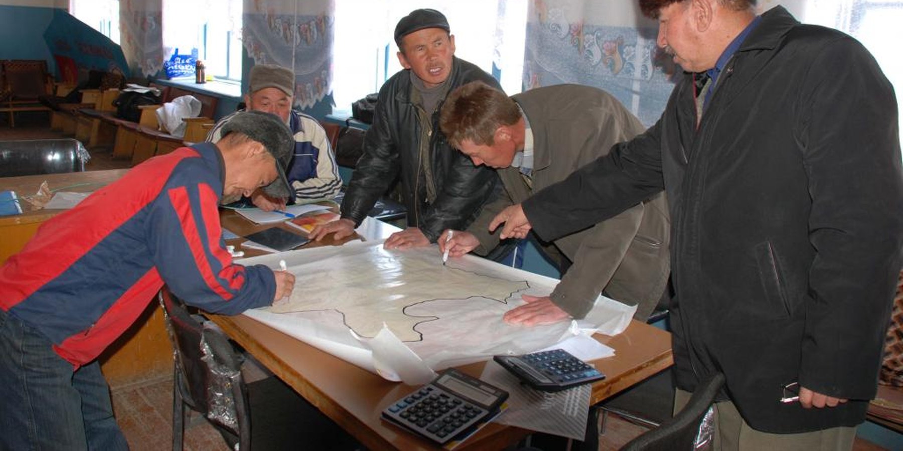
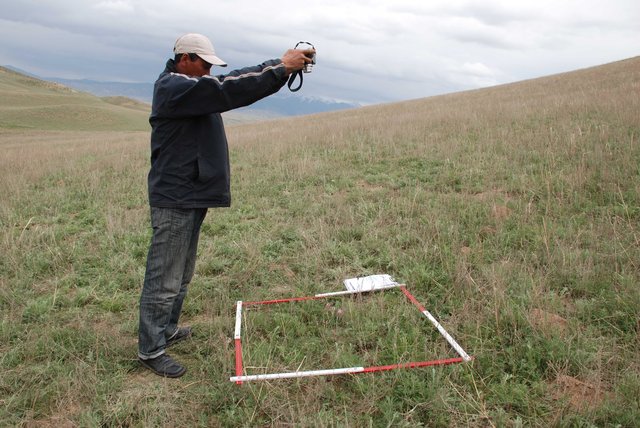
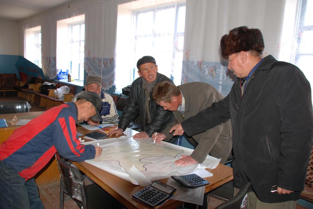
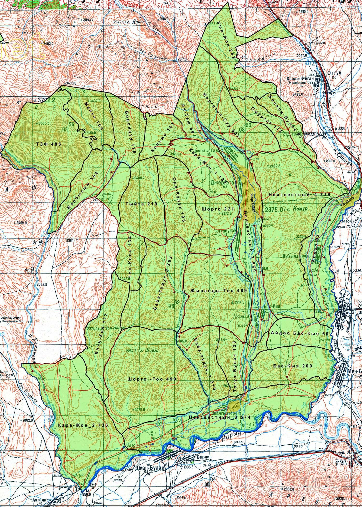
The implementation of this approach should be started with the collection of the available map materials of the aiyl okrug (A/O, aiyl okrug is an administrative and territorial unit consists of a group of villages, which has a local self-government), followed by the digitization of geobotanical maps of the pastures using the program Arc GIS 9 and specifying in the table of attributes the vegetation types, the gross production (phytomass per hectare), edible productivity. Among others, recommendations for the seasonal use of pastures are then being developed (this work was carried out by specialists of CAMP Alatoo PF). PastureCommittees first define the external borders of their pastures using old maps from the Soviet period. The newly established borders of pastures shall be agreed with neighboring aiyl okrugs. Where there are disputed territories consensus has to be achieved. Then, Pasture Committees determine the internal borders of pasture areas traditionally used by farmers. The natural barriers (rivers, ridges, rocks, etc.) usually serve as boundaries of the areas. Borders of pasture areas determined by the Pasture Committee are plotted on the geobotanical map. Based on this map, which shows the types of pastures in different pasture areas, the capacity of each pasture area is calculated. To obtain the capacity of the pasture areas in different seasons, the total capacity is multiplied by the coefficients for each season, which are defined and presented by Kyrgyz Designing Institute on Land Management “Kyrgyzgiprozem”. The results obtained will be plotted on four simple maps representing the carrying capacity of the pasture areas in spring, summer, autumn and winter. These maps are then used by the Pasture Committee for the development of their pasture use plans.
Role of stakeholders: Pasture use plans which are based on the mapping of pasture areas become binding for all pasture users after the approval by the general meeting of the Association of pasture users and the aiyl kenesh. (local authority) Accordingly, the meeting represents and defends the interests of the majority of pasture users, which represents both men and women.
Other important information: This approach has been implemented by CAMP Alatoo PF as part of a pilot project of the GIZ regional program “Sustainable Use of Natural Resources in Central Asia”.
2.3 Photos of the Approach
Media Gallery

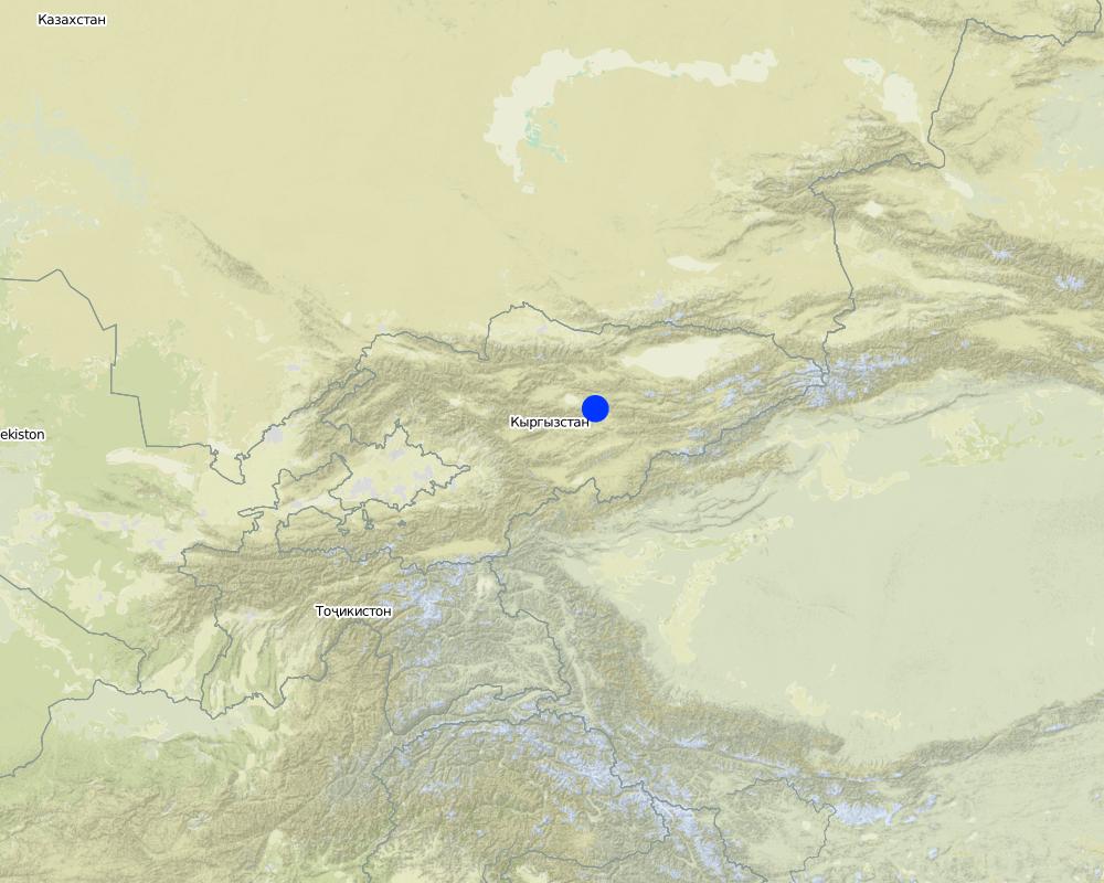
2.5 Country/ region/ locations where the Approach has been applied
Country:
Kyrgyzstan
Region/ State/ Province:
Naryn oblast
Further specification of location:
– Naryn rayon – Jergetal, Minbulak, Onarsha, Kazan-Kuygan, Emgekchil ail okrugs
Comments:
High-mountain, stock-breeding region (2200-4000 m above sea level).
Map
×2.6 Dates of initiation and termination of the Approach
Indicate year of initiation:
2009
Year of termination (if Approach is no longer applied):
2011
2.7 Type of Approach
- project/ programme based
2.8 Main aims/ objectives of the Approach
The Approach focused mainly on SLM with other activities (collection of map materials, digitizing maps, determination of the external borders of pastures, determination of internal borders of pastures, calculation of pasture capacity, pasture use plan. )
The main objective of this approach is to provide Pasture Committees with the skills to develop necessary map material, so that they fully perform their functions related to the development of pasture use plans.
The SLM Approach addressed the following problems: The lack of clearly defined (both external and internal) pasture boundaries leads to various problems in the use and management of pastures. First, the lack of boundaries leads to conflicts, both between neighboring Pasture Committees and between the pasture users, which is not beneficial for a sustainable pasture management. Second, the fact that the Pasture Committees have no map material showing pasture boundaries complicates the assessment of pasture condition and the establishment of pasture use plans, which aim at avoiding land degradation. Therefore, Pasture Committees need simple approaches for mapping their pastures. This approach is designed to help the Pasture Committees to resolve the problems arising due to a lack of defined pasture boundaries (above mentioned problems).
2.9 Conditions enabling or hindering implementation of the Technology/ Technologies applied under the Approach
social/ cultural/ religious norms and values
- hindering
Loss of traditional skills for a sustainable use of pasture resources
Treatment through the SLM Approach: Raising awareness of pasture users in sustainable pasture management.
institutional setting
- hindering
Not all pasture committees recognized the need to map the pasture areas with their own capacities and the need to plan the use of pastures.
Treatment through the SLM Approach: Conduct trainings on the rights and obligations of Pasture Committees, and on planning the seasonal use of pastures using maps.
legal framework (land tenure, land and water use rights)
- hindering
This approach is fully consistent with the current legislation of Kyrgyzstan.
knowledge about SLM, access to technical support
- hindering
The approach requires the availability of GIS professionals.
Treatment through the SLM Approach: Increase the capacity of young GIS professionals in the regions.
other
- hindering
Pasture Committees have little working experience with map materials due to a lack of maps.
Treatment through the SLM Approach: Provide maps, teach the basics of mapping.
3. Participation and roles of stakeholders involved
3.1 Stakeholders involved in the Approach and their roles
- local land users/ local communities
Great difference between the participation of women and men is not the result of gender discrimination. Historically, men are responsible for the livestock and related activities in the family. However, if desired, women can participate in this process as well as men
Members of the Pasture Committees represent all segments of the population (small, medium and large farmers, representatives of villages, clans).
Pasture borders were established mainly by members of Pasture Committees with land expert of aiyl okrug.
- SLM specialists/ agricultural advisers
Pasture Department and consulting services were involved in the dissemination of this approach
- NGO
САМР Alatoo Public Foundation
- national government (planners, decision-makers)
This approach is partly included in the guidebook for developing pasture management plans for pasture committees approved by the Ministry of Agriculture of the Kyrgyz Republic.
3.2 Involvement of local land users/ local communities in the different phases of the Approach
| Involvement of local land users/ local communities | Specify who was involved and describe activities | |
|---|---|---|
| initiation/ motivation | interactive | Seminars to raise awareness of pasture users, round tables, meetings with experts. |
| planning | interactive | Planning of the approach was carried out with the active participation of members of the Pasture Committees and the communities. |
| implementation | interactive | Pasture Committees determined the external and internal borders of pasture areas, which is part of the work for the implementation of the approach in practice. |
| monitoring/ evaluation | none | |
| Research | none |
3.3 Flow chart (if available)
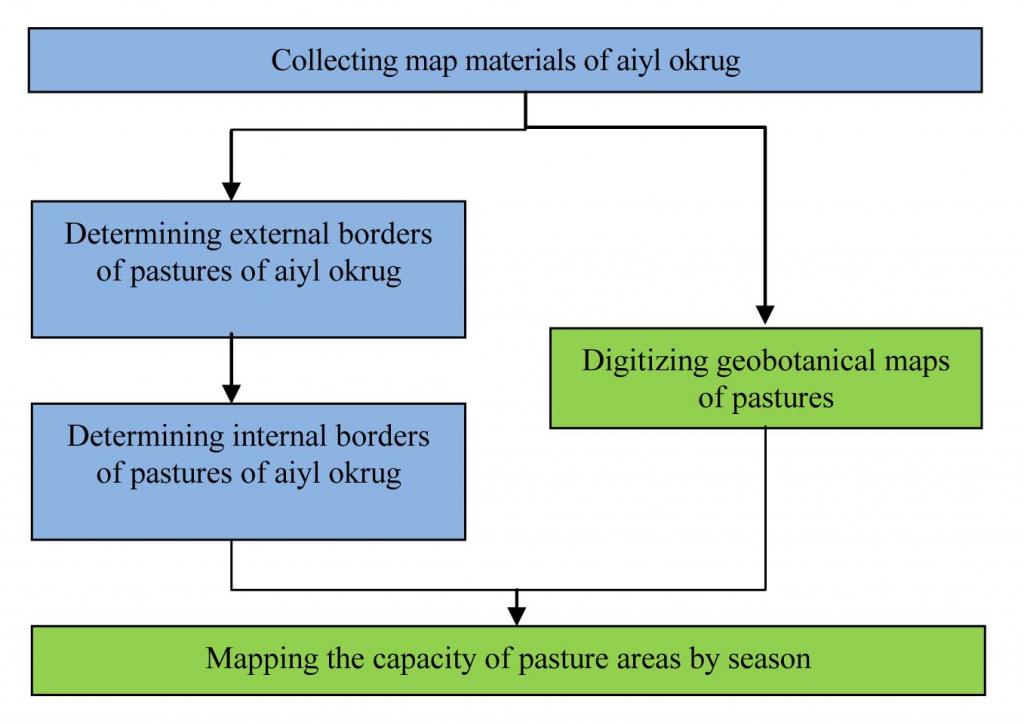
Description:
Pasture mapping scheme (activities performed by Pasture Committees are highlighted in blue, activities performed by CAMP Alatoo PF are highlighted in green).
Author:
Azamat Isakov (3, Uphimskiy pereulok Bishkek)
3.4 Decision-making on the selection of SLM Technology/ Technologies
Specify who decided on the selection of the Technology/ Technologies to be implemented:
- mainly land users, supported by SLM specialists
Explain:
External and internal borders of pastures were determined by Pasture Committees. Digitizing of geobotanical maps and evaluation of pasture capacity were carried out by specialists of the project. Pasture Committees made corrections on the finished maps of pasture capacity on their own.
Decisions on the method of implementing the SLM Technology were made by mainly by land users supported by SLM specialists. This approach was proposed mainly by project specialists.
4. Technical support, capacity building, and knowledge management
4.1 Capacity building/ training
Was training provided to land users/ other stakeholders?
Yes
Specify who was trained:
- land users
- field staff/ advisers
Form of training:
- farmer-to-farmer
- public meetings
Form of training:
- seminars
Subjects covered:
This approach was included in the training of trainers, which was conducted throughout the country. The trainees gain the skills to map, as well as the necessary knowledge on the capacity of pastures, their rotation and the effect of pasture rotation on their condition (carrying capacity).
4.2 Advisory service
Do land users have access to an advisory service?
Yes
Specify whether advisory service is provided:
- on land users' fields
Describe/ comments:
Name of method used for advisory service: Mapping as a basis for the development of pasture use plans.; Key elements: Mapping internal and external borders of pastures., Mapping the capacity of pastures.; External borders of pastures of aiyl okrugs are a basis for conflicts. In addition, not all pasture users follow the pasture use plan. Required a clear determination of the external borders and their formalization. The approach involves monitoring of pasture areas to clarify the pasture capacity and to plan their more balanced use, as available data on the capacity of pastures are old. Further efforts to raise the awareness of pasture users about the importance of pasture use planning are required.
Advisory service is quite adequate to ensure the continuation of land conservation activities; The extension system is quite adequate to ensure a continuation of the activities. In accordance with the Law 'On Pastures' of the Kyrgyz Republic, Pasture committees were created in all aiyl okrugs. These Pature committees need to develop an annual pasture use plan, according to the capacity of their pasture areas and the actual number of livestock. The Pasture Department of the Ministry of Agriculture uses this approach in the development of teaching materials for the Pasture Committees. In addition, the employees of the Pasture Department are trained in this approach and are able to provide trainings on mapping.
4.3 Institution strengthening (organizational development)
Have institutions been established or strengthened through the Approach?
- no
4.4 Monitoring and evaluation
Is monitoring and evaluation part of the Approach?
Yes
Comments:
Bio-physical aspects were regular monitored by project staff, land users through measurements; indicators: Dynamics of biophysical changes (monitoring of the pasture condition based on pasture capacity maps).
Technical aspects were regular monitored by land users through observations; indicators: % of compliance with the grazing schedules and pasture use plan (monitoring).
Economic / production aspects were regular monitored by project staff, land users through measurements; indicators: Condition of livestock.
No. of land users involved aspects were regular monitored by land users through measurements; indicators: % of involved pasture users.
There were no changes in the Approach as a result of monitoring and evaluation
There were no changes in the Technology as a result of monitoring and evaluation
4.5 Research
Was research part of the Approach?
No
5. Financing and external material support
5.1 Annual budget for the SLM component of the Approach
If precise annual budget is not known, indicate range:
- 10,000-100,000
Comments (e.g. main sources of funding/ major donors):
Approach costs were met by the following donors: international (The approach is implemented by means of GIZ ): 100.0%
5.2 Financial/ material support provided to land users
Did land users receive financial/ material support for implementing the Technology/ Technologies?
No
5.3 Subsidies for specific inputs (including labour)
If labour by land users was a substantial input, was it:
- rewarded with other material support
Comments:
The development of pasture use plans based on the pasture capacity maps is a functional responsibility of the Pasture committees. Their members receive a salary for the implementation of functional responsibilities out of the Pasture committee's own budget.
Pasture users are not aware of the need of such costs. Required measures to raise awareness and capacity of pasture users, local parliaments, representatives of local governments.
5.4 Credit
Was credit provided under the Approach for SLM activities?
No
6. Impact analysis and concluding statements
6.1 Impacts of the Approach
Did the Approach help land users to implement and maintain SLM Technologies?
- No
- Yes, little
- Yes, moderately
- Yes, greatly
The implementation of this approach has enabled the development of pasture use plans taking into account the pasture capacity on a territory of 250,000 hectares of pastures within the pilot area.
Did the Approach empower socially and economically disadvantaged groups?
- No
- Yes, little
- Yes, moderately
- Yes, greatly
The poor population, among other population strata, was able to determine the boundaries of its pastures and assess their capacity.
Did other land users / projects adopt the Approach?
- No
- Yes, little
- Yes, moderately
- Yes, greatly
The World Bank project 'Agricultural Investments and Services', component of 'Pasture Management'. The project developed a guidebook for Pasture Committees on how to prepare Pasture Management Plans, where this approach is used for the development of pasture use plans. This manual is being used by all the 454 Pasture Committees in Kyrgyzstan.
Did the Approach lead to improved livelihoods / human well-being?
- No
- Yes, little
- Yes, moderately
- Yes, greatly
The proper distribution of livestock on pastures in accordance with their capacity prevents the degradation of pastures, resulting in improved condition of livestock, which in turn increases revenues.
Did the Approach help to alleviate poverty?
- No
- Yes, little
- Yes, moderately
- Yes, greatly
The approach has resulted in a balanced distribution of livestock on pasture areas, thereby increasing income from animal husbandry.
6.2 Main motivation of land users to implement SLM
- rules and regulations (fines)/ enforcement
The Law requires the development of pasture use plans based on pasture capacity mapping.
- affiliation to movement/ project/ group/ networks
The approach is tested within the framework of a pilot project.
- environmental consciousness
Awareness of environmental issues, reduction of the degradation of pastures.
- well-being and livelihoods improvement
Improvements in the nutritional status of livestock.
6.3 Sustainability of Approach activities
Can the land users sustain what has been implemented through the Approach (without external support)?
- yes
If yes, describe how:
The pasture use plan based on pasture mapping is a part of the pasture management plan. A funding mechanism for the implementation of the pasture management plan, which is based on the payment for grazing by pasture users, is provided by the legislation of the Kyrgyz Republic. These payments form the budget of the Pasture Committee. The total sum of the budget depends on the pasture use plan and the activities planned to improve the infrastructure as well as the pasture condition. This mechanism ensures the financial sustainability of this approach. However, the implementation of the approach also requires mapping skills, which can be achieved through training of the members of the Pasture Committee.
6.4 Strengths/ advantages of the Approach
| Strengths/ advantages/ opportunities in the land user’s view |
|---|
|
Ability to plan pasture use (How to sustain/ enhance this strength: 1) Training on working with maps in practice and on monitoring the capacity of pastures 2) Monitoring the implementation of the pasture use plan 3) Create new income-generating activities as an alternative to increasing the number of livestock) |
| Achieving a stable income from livestock |
| Strengths/ advantages/ opportunities in the compiler’s or other key resource person’s view |
|---|
|
Participation of the local community in the definition of the boundaries of their pastures, which increases their responsibility for them (How to sustain/ enhance this strength: 1) Attract more people, if possible by increasing their awareness 2) Increase the capacities of the Pasture Committee 3) Provide extension services to the Pasture Committees (e.g. through Rural Advisory Services - RAS)) |
| Reduction and prevention of degradation on pastures, conservation and restoration of pasture ecosystems. |
6.5 Weaknesses/ disadvantages of the Approach and ways of overcoming them
| Weaknesses/ disadvantages/ risks in the compiler’s or other key resource person’s view | How can they be overcome? |
|---|---|
| This approach requires special skills and software, such as GIS. |
1) Increase the capacity of GIS professionals 2) Assistance in providing the required pasture maps 3) Training the pasture users. |
| Pasture users lack skills on plan development, implementation and monitoring. |
7. References and links
7.1 Methods/ sources of information
- field visits, field surveys
- interviews with land users
7.2 References to available publications
Title, author, year, ISBN:
Busler S. «Community Pasture Management in Kyrgyzstan», Bishkek, 2011
Available from where? Costs?
САМР Alatoo PF
Title, author, year, ISBN:
Annual reports of САМР Alatoo for 2009, 2010, 2011
Available from where? Costs?
САМР Alatoo PF
7.3 Links to relevant information which is available online
Title/ description:
Law of the Kyrgyz Republic «On Pastures» dated 26 January 2009 No.30
URL:
www.toktom.kg
Links and modules
Expand all Collapse allLinks
Monitoring the condition of pastures (CACILM) [Kyrgyzstan]
Monitoring the state condition of pastures.
- Compiler: Azamat Isakov
Modules
No modules