Reduced tillage [Norway]
- Creation:
- Update:
- Compiler: Kamilla Skaalsveen
- Editor: –
- Reviewer: Fabian Ottiger
Redusert jordarbeiding
technologies_1245 - Norway
View sections
Expand all Collapse all1. General information
1.2 Contact details of resource persons and institutions involved in the assessment and documentation of the Technology
Name of project which facilitated the documentation/ evaluation of the Technology (if relevant)
Preventing and Remediating degradation of soils in Europe through Land Care (EU-RECARE )Name of the institution(s) which facilitated the documentation/ evaluation of the Technology (if relevant)
Norwegian Institute for Agricultural and Environme (Norwegian Institute for Agricultural and Environme) - Norway1.3 Conditions regarding the use of data documented through WOCAT
When were the data compiled (in the field)?
14/08/2014
The compiler and key resource person(s) accept the conditions regarding the use of data documented through WOCAT:
Yes
1.5 Reference to Questionnaire(s) on SLM Approaches

Regional Environmental program [Norway]
Regulations and financial grants for reduction of pollution and promotion of the cultural landscape.
- Compiler: Kamilla Skaalsveen
2. Description of the SLM Technology
2.1 Short description of the Technology
Definition of the Technology:
Reduced tillage of cropland areas to decrease erosion by water and soil loss.
2.2 Detailed description of the Technology
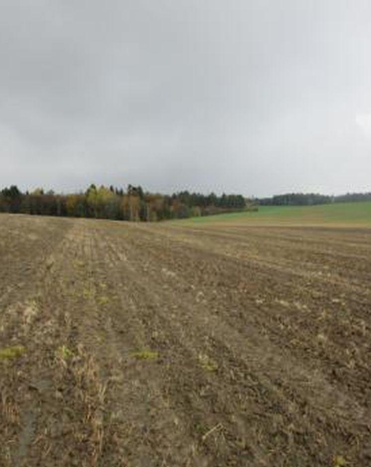
Description:
Cropland areas with high erosion risk are left as stubble fields after the harvesting is carried out and throughout the winter. Special regulations in the Morsa catchment (cf. morsa.org) suggest that tillage and fertilizer additions are postponed to the 1st of March at the earliest.
Purpose of the Technology: Reduced tillage is an efficient measure to prevent soil erosion and particle and nutrient
loss from cropland to watercourses. In addition to the protection of soil from water erosion, stubble fields contribute to heighten the organic matter content, which may also increase the
aggregate stability of the soil. it is also possible that higher biological activity may improve the soil structure.
Establishment / maintenance activities and inputs: It is of importance to keep in mind a potential increased amount of weeds and diseases (incl. fungi) when practicing this measure. The soil may also develop a rather dense structure over time if the climate is humid. On areas of low erosion risk, cultivation by autumn harrowing to a depth of 80 to 120 mm, followed by repetitive spring harrowing to a depth of 60 to 100
mm, may be beneficial. The methods are likely to contribute to faster decomposition of
plant material, and to reduce the occurrence of weeds. Direct seeding to stubble fields of young meadow is another method, but requires special equipment and is not very common in this catchment.
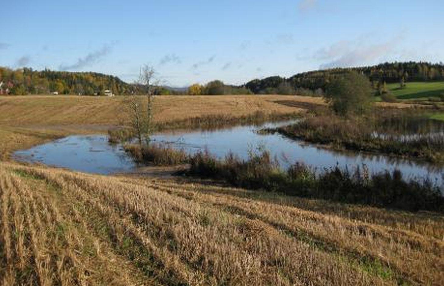
Natural / human environment: The Kråkstad River is mainly situated in Ski commune in Akershus County in South-Eastern parts of Norway. The river catchment is a tributary of the Vansjø-Hobøl watercourse, also known as the Morsa watercourse. The Kråkstad River catchment constitutes a total area of about 22 km², consisting mainly of cropland and forest/woodland. The recipient Vansjø is a eutrophic lake with a former history of algal blooms of toxic cyanobacterias. The lake is both used as a drinking water source and for recreational purposes.
2.3 Photos of the Technology
Media Gallery
2.5 Country/ region/ locations where the Technology has been applied and which are covered by this assessment
Country:
Norway
Region/ State/ Province:
Akershus
Further specification of location:
Ski
Comments:
Boundary points of the Technology area: (59.595, 10.896), (59.611, 10.866), (59.670, 10.869), (59.676, 10.849), (59.717, 10.844), (59.723, 10.893), (59.694, 10.969), (59.655, 10.952), (59.668, 10.904), (59.629, 10.915)
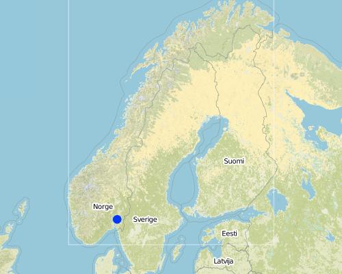
Map
×2.6 Date of implementation
If precise year is not known, indicate approximate date:
- 10-50 years ago
2.7 Introduction of the Technology
Specify how the Technology was introduced:
- during experiments/ research
3. Classification of the SLM Technology
3.2 Current land use type(s) where the Technology is applied

Cropland
- Annual cropping
Main crops (cash and food crops):
Major cash crop: Small grains
Comments:
Major land use problems (compiler’s opinion): Erosion, flooding and landslides, eutrophication of rivers and lakes
Major land use problems (land users’ perception): Increased usage of pesticides and reduced production
Future (final) land use (after implementation of SLM Technology): Cropland: Ca: Annual cropping
If land use has changed due to the implementation of the Technology, indicate land use before implementation of the Technology:
Cropland: Ca: Annual cropping
3.3 Further information about land use
Water supply for the land on which the Technology is applied:
- rainfed
Number of growing seasons per year:
- 1
Specify:
Longest growing period in days: 135Longest growing period from month to month: May 1 to mid-September
3.4 SLM group to which the Technology belongs
- minimal soil disturbance
3.5 Spread of the Technology
Comments:
Total area covered by the SLM Technology is 4.3 m2.
3.6 SLM measures comprising the Technology

agronomic measures
- A1: Vegetation/ soil cover
- A2: Organic matter/ soil fertility
Comments:
Main measures: agronomic measures
Type of agronomic measures: minimum tillage
3.7 Main types of land degradation addressed by the Technology

soil erosion by water
- Wt: loss of topsoil/ surface erosion
- Wg: gully erosion/ gullying

water degradation
- Hp: decline of surface water quality
Comments:
Main type of degradation addressed: Wt: loss of topsoil / surface erosion
Secondary types of degradation addressed: Wg: gully erosion / gullying, Hp: decline of surface water quality
Main causes of degradation: soil management, Heavy / extreme rainfall (intensity/amounts), governance / institutional
Secondary causes of degradation: deforestation / removal of natural vegetation (incl. forest fires), disturbance of water cycle (infiltration / runoff), change of seasonal rainfall, floods, land tenure
3.8 Prevention, reduction, or restoration of land degradation
Specify the goal of the Technology with regard to land degradation:
- prevent land degradation
- reduce land degradation
Comments:
Main goals: prevention of land degradation
Secondary goals: mitigation / reduction of land degradation
4. Technical specifications, implementation activities, inputs, and costs
4.1 Technical drawing of the Technology
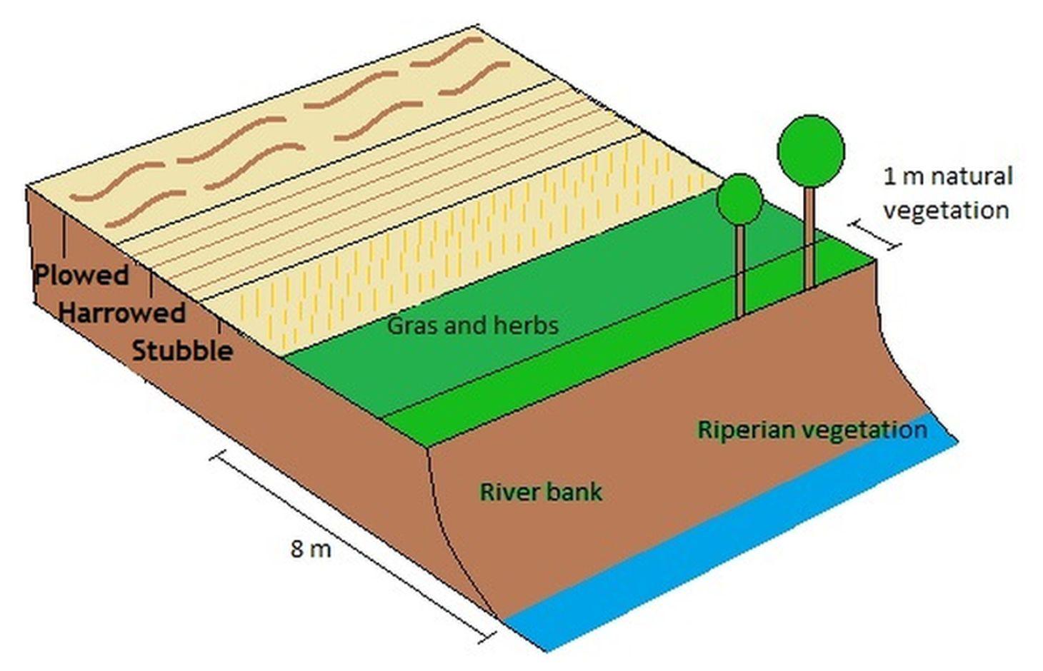
Author:
Kamilla Skaalsveen
4.2 Technical specifications/ explanations of technical drawing
A technical drawing of how a field may be divided into sections of reduced tilling (harrowed and stubble field) on high and moderate erosion risk areas, while it may be plowed on lower risk areas.
Technical knowledge required for field staff / advisors: low
Technical knowledge required for land users: low
Main technical functions: control of raindrop splash, control of dispersed runoff: retain / trap, control of concentrated runoff: impede / retard, improvement of ground cover, sediment retention / trapping, sediment harvesting
Secondary technical functions: control of dispersed runoff: impede / retard, increase of surface roughness, improvement of topsoil structure (compaction), increase in organic matter, increase of infiltration, improvement of water quality, buffering / filtering water, increase of biomass (quantity)
Minimum tillage
Material/ species: Stubble field, harrowing etc.
Remarks: Dependent on erosion risk classes
4.4 Establishment activities
Comments:
No initial investement
4.6 Maintenance/ recurrent activities
Comments:
The measure does not lead to any additional expenses for the land user
4.8 Most important factors affecting the costs
Describe the most determinate factors affecting the costs:
The measure does not lead to any additional costs for the land user
5. Natural and human environment
5.1 Climate
Annual rainfall
- < 250 mm
- 251-500 mm
- 501-750 mm
- 751-1,000 mm
- 1,001-1,500 mm
- 1,501-2,000 mm
- 2,001-3,000 mm
- 3,001-4,000 mm
- > 4,000 mm
Agro-climatic zone
- sub-humid
- semi-arid
Thermal climate class: temperate
Thermal climate class: boreal
5.2 Topography
Slopes on average:
- flat (0-2%)
- gentle (3-5%)
- moderate (6-10%)
- rolling (11-15%)
- hilly (16-30%)
- steep (31-60%)
- very steep (>60%)
Landforms:
- plateau/plains
- ridges
- mountain slopes
- hill slopes
- footslopes
- valley floors
Altitudinal zone:
- 0-100 m a.s.l.
- 101-500 m a.s.l.
- 501-1,000 m a.s.l.
- 1,001-1,500 m a.s.l.
- 1,501-2,000 m a.s.l.
- 2,001-2,500 m a.s.l.
- 2,501-3,000 m a.s.l.
- 3,001-4,000 m a.s.l.
- > 4,000 m a.s.l.
5.3 Soils
Soil depth on average:
- very shallow (0-20 cm)
- shallow (21-50 cm)
- moderately deep (51-80 cm)
- deep (81-120 cm)
- very deep (> 120 cm)
Soil texture (topsoil):
- fine/ heavy (clay)
Topsoil organic matter:
- medium (1-3%)
If available, attach full soil description or specify the available information, e.g. soil type, soil PH/ acidity, Cation Exchange Capacity, nitrogen, salinity etc.
Soil fertility is medium-high
Soil drainage/infiltration is poor
Soil water storage capacity is very low-low
5.4 Water availability and quality
Ground water table:
< 5 m
Availability of surface water:
good
Water quality (untreated):
for agricultural use only (irrigation)
5.5 Biodiversity
Species diversity:
- low
5.6 Characteristics of land users applying the Technology
Market orientation of production system:
- mixed (subsistence/ commercial
- commercial/ market
Off-farm income:
- > 50% of all income
Relative level of wealth:
- average
- rich
Individuals or groups:
- individual/ household
Level of mechanization:
- mechanized/ motorized
Gender:
- women
- men
Indicate other relevant characteristics of the land users:
Land users applying the Technology are mainly common / average land users
Population density: < 10 persons/km2
Annual population growth: < 0.5%
10% of the land users are rich and own 10% of the land.
90% of the land users are average wealthy and own 90% of the land.
5.7 Average area of land owned or leased by land users applying the Technology
- < 0.5 ha
- 0.5-1 ha
- 1-2 ha
- 2-5 ha
- 5-15 ha
- 15-50 ha
- 50-100 ha
- 100-500 ha
- 500-1,000 ha
- 1,000-10,000 ha
- > 10,000 ha
Is this considered small-, medium- or large-scale (referring to local context)?
- medium-scale
5.8 Land ownership, land use rights, and water use rights
Land ownership:
- individual, titled
Land use rights:
- individual
Water use rights:
- open access (unorganized)
5.9 Access to services and infrastructure
health:
- poor
- moderate
- good
education:
- poor
- moderate
- good
technical assistance:
- poor
- moderate
- good
employment (e.g. off-farm):
- poor
- moderate
- good
markets:
- poor
- moderate
- good
energy:
- poor
- moderate
- good
roads and transport:
- poor
- moderate
- good
drinking water and sanitation:
- poor
- moderate
- good
financial services:
- poor
- moderate
- good
6. Impacts and concluding statements
6.1 On-site impacts the Technology has shown
Socio-economic impacts
Production
crop production
risk of production failure
land management
Income and costs
farm income
workload
Socio-cultural impacts
SLM/ land degradation knowledge
Improved livelihoods and human well-being
Ecological impacts
Water cycle/ runoff
water quality
surface runoff
evaporation
Soil
soil cover
soil loss
soil compaction
Biodiversity: vegetation, animals
biomass/ above ground C
beneficial species
6.2 Off-site impacts the Technology has shown
downstream flooding
downstream siltation
damage on public/ private infrastructure
6.3 Exposure and sensitivity of the Technology to gradual climate change and climate-related extremes/ disasters (as perceived by land users)
Gradual climate change
Gradual climate change
| Season | Type of climatic change/ extreme | How does the Technology cope with it? | |
|---|---|---|---|
| annual temperature | increase | well |
Climate-related extremes (disasters)
Meteorological disasters
| How does the Technology cope with it? | |
|---|---|
| local rainstorm | well |
| local windstorm | well |
Climatological disasters
| How does the Technology cope with it? | |
|---|---|
| drought | well |
Hydrological disasters
| How does the Technology cope with it? | |
|---|---|
| general (river) flood | well |
Other climate-related consequences
Other climate-related consequences
| How does the Technology cope with it? | |
|---|---|
| reduced growing period | well |
6.4 Cost-benefit analysis
How do the benefits compare with the establishment costs (from land users’ perspective)?
Short-term returns:
negative
Long-term returns:
slightly negative
How do the benefits compare with the maintenance/ recurrent costs (from land users' perspective)?
Short-term returns:
slightly negative
Long-term returns:
slightly negative
6.5 Adoption of the Technology
Comments:
Comments on acceptance with external material support: Local regulations determine that farmers only receive subsidies per production area along with financial grants if they implement the technology.
There is no trend towards spontaneous adoption of the Technology
6.7 Strengths/ advantages/ opportunities of the Technology
| Strengths/ advantages/ opportunities in the compiler’s or other key resource person’s view |
|---|
|
Reduced soil loss and erosion How can they be sustained / enhanced? maintain the regulation that land in high erosion classes should not be plowed in autumn |
6.8 Weaknesses/ disadvantages/ risks of the Technology and ways of overcoming them
| Weaknesses/ disadvantages/ risks in the compiler’s or other key resource person’s view | How can they be overcome? |
|---|---|
| Higher demand for pesticides | Autumn and spring harrowing |
Links and modules
Expand all Collapse allLinks
Regional Environmental program [Norway]
Regulations and financial grants for reduction of pollution and promotion of the cultural landscape.
- Compiler: Kamilla Skaalsveen
Modules
No modules