Rehabilitation of degraded land [Moldova, Republic of]
- Creation:
- Update:
- Compiler: Valentin Ciubotaru
- Editors: Valentin Ciubotaru, UNCCD PRAIS
- Reviewers: Farrukh Nazarmavloev, William Critchley, Rima Mekdaschi Studer
Reabilitarea pamanturilor degradate
technologies_1819 - Moldova, Republic of
View sections
Expand all Collapse all1. General information
1.2 Contact details of resource persons and institutions involved in the assessment and documentation of the Technology
Key resource person(s)
SLM specialist:
1.3 Conditions regarding the use of data documented through WOCAT
When were the data compiled (in the field)?
02/06/2014
The compiler and key resource person(s) accept the conditions regarding the use of data documented through WOCAT:
Yes
1.4 Declaration on sustainability of the described Technology
Is the Technology described here problematic with regard to land degradation, so that it cannot be declared a sustainable land management technology?
No
Comments:
The technology described here is sustainable land management
2. Description of the SLM Technology
2.1 Short description of the Technology
Definition of the Technology:
Participatory land management was used to develop, and implement, SLM practices on slopes in order to rehabilitate degraded land. The local population were involved from the beginning. They took part in soil, water and biodiversity research, as well as the formulation and implementation of the land management plan, based on suitable SLM practices. In order to benefit from local knowledge, participatory training included traditional experience in soil conservation, and based on this, appropriate SLM technologies were included in the plan of action.
2.2 Detailed description of the Technology
Description:
The distinctive feature of this approach to rehabilitating degraded land on slopes was the involvement of the local population from the beginning. They took part in soil, water and biodiversity research, as well as the development and implementation of the land management plan, based on suitable SLM practices. In order to benefit from local knowledge, participatory training included traditional experience in soil conservation, and based on this, appropriate SLM technologies were included in the plan of action.
The following stakeholders were involved in the overall process:
• Researchers: overseeing soil, water and biodiversity research and presenting results.
• Experts: proposing alternatives in the organization of the land and in the development of integrated management system for the landscape based on research results.
• Local public administration, Joint Stock Company and farmers: contributing with knowledge and experience in analysing land, water and biodiversity resources, preparation and implementation of the action plan.
• NGO BIOS: coordinating all activities, including research, implementation, training and monitoring of activities.
The land management plan was developed together with the local population, then it was implemented. Degraded areas (landslides and heavily eroded soils) were excluded from agricultural production and used for afforestation and grassland. The following soil and water conservation practices are applied:
Vineyards and orchards:
• Conservation tillage
• Forest belts
• Grass inter-rows in vineyards and orchards
Arable land:
• Crop rotation
• Application of mineral and organic fertilizers
• Strip cropping
• Conservation tillage,
• Forest belts.
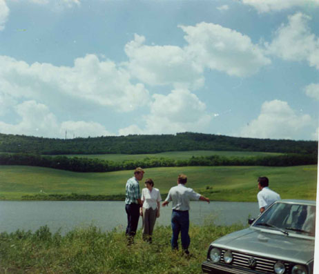
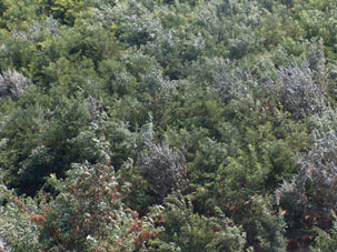
2.3 Photos of the Technology
Media Gallery
2.5 Country/ region/ locations where the Technology has been applied and which are covered by this assessment
Country:
Moldova, Republic of
Region/ State/ Province:
Central Region of the Republic of Moldova
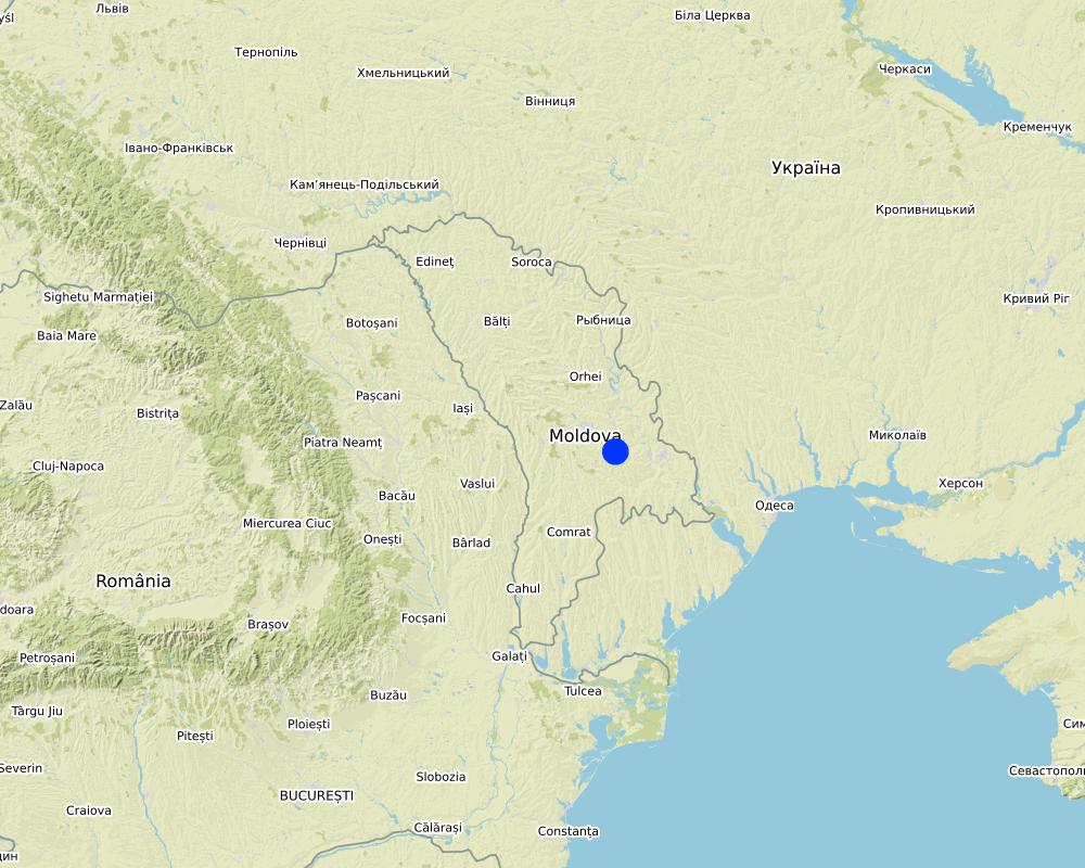
Map
×2.6 Date of implementation
Indicate year of implementation:
1998
If precise year is not known, indicate approximate date:
- 10-50 years ago
2.7 Introduction of the Technology
Specify how the Technology was introduced:
- through projects/ external interventions
3. Classification of the SLM Technology
3.1 Main purpose(s) of the Technology
- reduce, prevent, restore land degradation
- protect a watershed/ downstream areas – in combination with other Technologies
3.2 Current land use type(s) where the Technology is applied

Cropland
- Annual cropping
- Tree and shrub cropping
Main crops (cash and food crops):
Vineyards, wheat, barley, maize, sunflower.

Forest/ woodlands
(Semi-)natural forests/ woodlands:
- Selective felling
Tree plantation, afforestation:
- Mixed varieties
Products and services:
- Fuelwood
- Fruits and nuts
- Grazing/ browsing
- Nature conservation/ protection
- Recreation/ tourism
If land use has changed due to the implementation of the Technology, indicate land use before implementation of the Technology:
About 150 ha of degraded land (landslides) were taken out of agricultural production and transferred to afforestation
3.3 Further information about land use
Water supply for the land on which the Technology is applied:
- rainfed
Number of growing seasons per year:
- 1
3.4 SLM group to which the Technology belongs
- rotational systems (crop rotation, fallows, shifting cultivation)
- integrated soil fertility management
- integrated pest and disease management (incl. organic agriculture)
3.5 Spread of the Technology
Specify the spread of the Technology:
- evenly spread over an area
If the Technology is evenly spread over an area, indicate approximate area covered:
- 100-1,000 km2
3.6 SLM measures comprising the Technology

agronomic measures
- A1: Vegetation/ soil cover
- A2: Organic matter/ soil fertility

vegetative measures
- V1: Tree and shrub cover
- V2: Grasses and perennial herbaceous plants
- V3: Clearing of vegetation
- V4: Replacement or removal of alien/ invasive species

structural measures
- S3: Graded ditches, channels, waterways
- S5: Dams, pans, ponds
- S6: Walls, barriers, palisades, fences

management measures
- M1: Change of land use type
- M6: Waste management (recycling, re-use or reduce)
3.7 Main types of land degradation addressed by the Technology

soil erosion by water
- Wt: loss of topsoil/ surface erosion
- Wg: gully erosion/ gullying
- Wm: mass movements/ landslides

chemical soil deterioration

biological degradation
- Bc: reduction of vegetation cover
- Bh: loss of habitats
- Bq: quantity/ biomass decline
- Bf: detrimental effects of fires
- Bs: quality and species composition/ diversity decline
- Bl: loss of soil life
- Bp: increase of pests/ diseases, loss of predators
3.8 Prevention, reduction, or restoration of land degradation
Specify the goal of the Technology with regard to land degradation:
- prevent land degradation
- reduce land degradation
4. Technical specifications, implementation activities, inputs, and costs
4.1 Technical drawing of the Technology
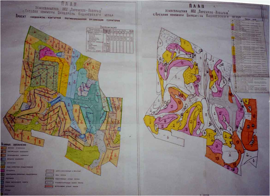
Author:
Capus, Institute for Territory Planning "Ghiprozem"
Date:
01/06/2008
4.4 Establishment activities
| Activity | Type of measure | Timing | |
|---|---|---|---|
| 1. | Regeneration of degraded commune forest as well as existing forest protective belts | ||
| 2. | Soil conservation tillage | ||
| 3. | Planting of grass in inter raw of vineyards and orchards together with contour tillage and other soil conservation | ||
| 4. | Earth dam structure |
5. Natural and human environment
5.1 Climate
Annual rainfall
- < 250 mm
- 251-500 mm
- 501-750 mm
- 751-1,000 mm
- 1,001-1,500 mm
- 1,501-2,000 mm
- 2,001-3,000 mm
- 3,001-4,000 mm
- > 4,000 mm
Specify average annual rainfall (if known), in mm:
550.00
Indicate the name of the reference meteorological station considered:
State Hydrometeorological Service
Agro-climatic zone
- sub-humid
The climate is moderately continental: the summers are warm and long, with temperatures averaging about 20°C, and the winters are relatively mild and dry, with January temperatures averaging -4°C. Annual rainfall, which ranges from around 500 millimetres; long dry spells are not unusual. The heaviest rainfall occurs in summer; heavy showers and thunderstorms are common.
5.2 Topography
Slopes on average:
- flat (0-2%)
- gentle (3-5%)
- moderate (6-10%)
- rolling (11-15%)
- hilly (16-30%)
- steep (31-60%)
- very steep (>60%)
Landforms:
- plateau/plains
- ridges
- mountain slopes
- hill slopes
- footslopes
- valley floors
Altitudinal zone:
- 0-100 m a.s.l.
- 101-500 m a.s.l.
- 501-1,000 m a.s.l.
- 1,001-1,500 m a.s.l.
- 1,501-2,000 m a.s.l.
- 2,001-2,500 m a.s.l.
- 2,501-3,000 m a.s.l.
- 3,001-4,000 m a.s.l.
- > 4,000 m a.s.l.
Comments and further specifications on topography:
The territory of Cretoaia village is situated in the Central Moldavian Plateau, at an average elevation of about 350 m. It is interlaced by deep, flat valleys, ravines, and landslide-scoured depressions.|
5.3 Soils
Soil depth on average:
- very shallow (0-20 cm)
- shallow (21-50 cm)
- moderately deep (51-80 cm)
- deep (81-120 cm)
- very deep (> 120 cm)
Soil texture (topsoil):
- medium (loamy, silty)
Soil texture (> 20 cm below surface):
- medium (loamy, silty)
Topsoil organic matter:
- medium (1-3%)
If available, attach full soil description or specify the available information, e.g. soil type, soil PH/ acidity, Cation Exchange Capacity, nitrogen, salinity etc.
Chernozems (black soils) prevail (80% of the area), however they are degraded. About 50% of the land has a gradient from 2 to 6 degrees, while 30% of the land has an inclination exceeding 6 degree. Water erosion processes are widespread and quite intense. The predominant length of the hillsides in Cretoaia is over 900 m.
5.4 Water availability and quality
Ground water table:
5-50 m
Availability of surface water:
poor/ none
Water quality (untreated):
poor drinking water (treatment required)
Is water salinity a problem?
No
Is flooding of the area occurring?
Yes
Regularity:
episodically
5.5 Biodiversity
Species diversity:
- medium
Habitat diversity:
- medium
5.6 Characteristics of land users applying the Technology
Sedentary or nomadic:
- Sedentary
Market orientation of production system:
- mixed (subsistence/ commercial
Off-farm income:
- 10-50% of all income
Relative level of wealth:
- poor
Individuals or groups:
- individual/ household
- groups/ community
Level of mechanization:
- mechanized/ motorized
Gender:
- women
- men
Age of land users:
- middle-aged
- elderly
Indicate other relevant characteristics of the land users:
The estimated average income per capita in the community over the last 3 years was 70 US dollars per month. The principal activity in the commune is agriculture. The farmers cultivate arable crops, grapes, fruits and vegetables. People also have cattle, sheep and goats in their household, mainly for home consumption and some extra for sale. There is a foodstuffs and a macaroni factory in the village, where the local population work.
5.7 Average area of land owned or leased by land users applying the Technology
- < 0.5 ha
- 0.5-1 ha
- 1-2 ha
- 2-5 ha
- 5-15 ha
- 15-50 ha
- 50-100 ha
- 100-500 ha
- 500-1,000 ha
- 1,000-10,000 ha
- > 10,000 ha
Is this considered small-, medium- or large-scale (referring to local context)?
- small-scale
Comments:
People in the community have plots of about 4 hectares per household - which belong to them - and they have title deeds and land maps to prove it.
5.8 Land ownership, land use rights, and water use rights
Land ownership:
- communal/ village
- individual, titled
Land use rights:
- communal (organized)
- individual
Water use rights:
- communal (organized)
- individual
5.9 Access to services and infrastructure
health:
- poor
- moderate
- good
education:
- poor
- moderate
- good
technical assistance:
- poor
- moderate
- good
employment (e.g. off-farm):
- poor
- moderate
- good
markets:
- poor
- moderate
- good
energy:
- poor
- moderate
- good
roads and transport:
- poor
- moderate
- good
drinking water and sanitation:
- poor
- moderate
- good
financial services:
- poor
- moderate
- good
6. Impacts and concluding statements
6.1 On-site impacts the Technology has shown
Socio-economic impacts
Production
wood production
land management
Ecological impacts
Soil
soil loss
6.2 Off-site impacts the Technology has shown
Comments regarding impact assessment:
The expected environmental impact of the initiated actions are significant, especially in the long run. Expected changes include diminishing landslide activity, the soil erosion rates, changes in existing land use management, changes in the landscape, etc.|
The sustainable technologies were proposed and implemented for the soil to be productive. The increased production on the land were fertilizers applied in combination with soil conservation practices.
Men found another occupation - fishing in the constructed water reservoir, while for the community is meant a recreation facility. The expected social impact of implemented practices include increased jobs for people, and increases in agricultural productivity.
6.4 Cost-benefit analysis
How do the benefits compare with the establishment costs (from land users’ perspective)?
Short-term returns:
neutral/ balanced
Long-term returns:
positive
How do the benefits compare with the maintenance/ recurrent costs (from land users' perspective)?
Short-term returns:
neutral/ balanced
Long-term returns:
slightly positive
6.5 Adoption of the Technology
- single cases/ experimental
Of all those who have adopted the Technology, how many have did so spontaneously, i.e. without receiving any material incentives/ payments?
- 10-50%
6.6 Adaptation
Has the Technology been modified recently to adapt to changing conditions?
No
6.7 Strengths/ advantages/ opportunities of the Technology
| Strengths/ advantages/ opportunities in the compiler’s or other key resource person’s view |
|---|
|
1. Highly motivated local governments. 2. Bad weather which has led to intensifying activity against landslides 3. Clearly expressed objectives and expectations in respect to individual benefits. All these can be replicated anywhere. |
7. References and links
7.1 Methods/ sources of information
- compilation from reports and other existing documentation
10
7.2 References to available publications
Title, author, year, ISBN:
Elena Bivol, Valentin Ciubotaru Urban Agriculture in Chisinau, Republic of Moldova / NGO BIOS, Chisinau, 2005, 60 p.
Available from where? Costs?
NGO BIOS 72/3 Columna str., office nr. 3, Chisinau, MD-2009, Republic of Moldova Tel./Fax: +(373-22) 545733; +(373-22) 723372 GSM: +(373) 69134294 .
Links and modules
Expand all Collapse allLinks
No links
Modules
No modules