Gully control by plantation of Atriplex [Morocco]
- Creation:
- Update:
- Compiler: Laouina Abdellah
- Editor: –
- Reviewers: Alexandra Gavilano, Fabian Ottiger
technologies_1110 - Morocco
- Full summary as PDF
- Full summary as PDF for print
- Full summary in the browser
- Full summary (unformatted)
- Gully control by plantation of Atriplex: May 29, 2019 (public)
- Gully control by plantation of Atriplex: Aug. 11, 2017 (inactive)
- Gully control by plantation of Atriplex: Aug. 6, 2017 (inactive)
- Gully control by plantation of Atriplex: June 5, 2017 (inactive)
- Gully control by plantation of Atriplex: Dec. 28, 2016 (inactive)
View sections
Expand all Collapse all1. General information
1.2 Contact details of resource persons and institutions involved in the assessment and documentation of the Technology
Name of project which facilitated the documentation/ evaluation of the Technology (if relevant)
DESIRE (EU-DES!RE)Name of the institution(s) which facilitated the documentation/ evaluation of the Technology (if relevant)
Chaire Unesco-GN, Faculté des Lettres et des Sciences Humaines, Université Moham (Chaire Unesco-GN, Faculté des Lettres et des Sciences Humaines, Université Moham) - Morocco1.3 Conditions regarding the use of data documented through WOCAT
When were the data compiled (in the field)?
15/05/2011
The compiler and key resource person(s) accept the conditions regarding the use of data documented through WOCAT:
Yes
2. Description of the SLM Technology
2.1 Short description of the Technology
Definition of the Technology:
Rehabilitation of a gullied slope and gully control, by plantation of Atriplex halimus fodder shrubs.
2.2 Detailed description of the Technology
Description:
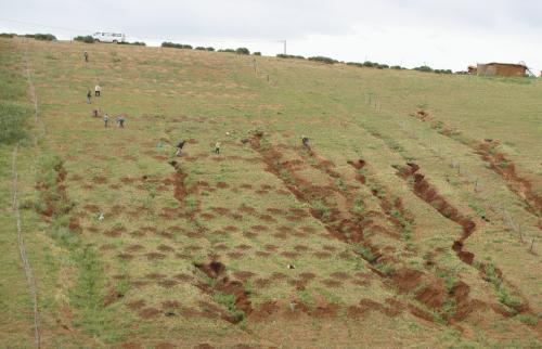
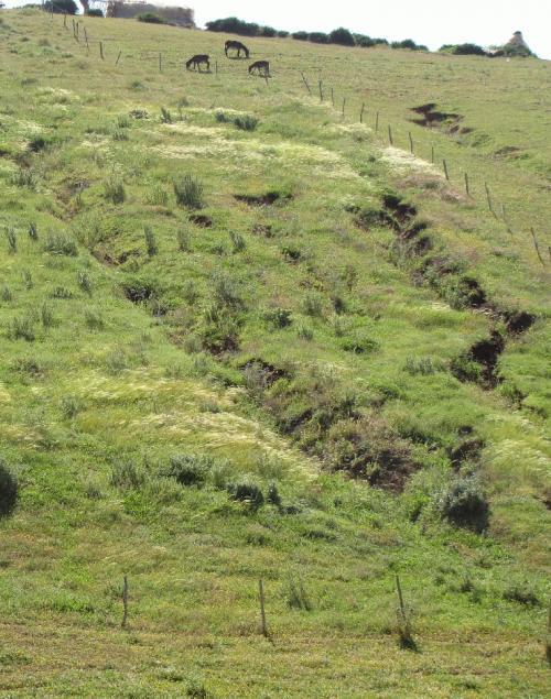
The experimental plot, with a size of 5000m², corresponds to an old fallow field and strongly gullied slope. The gullies are parallel and start around the middle of the slope. They extend by retreat of the gully heads upslope. Each gully is 2 to 4 m large and 1 to 2 m deep and up to 120 m long. Downslope, the gullies lose their depth and deposit fans composed of material eroded upstream, before they join the channel of Hannanet, which has the tendency to incise its bed (more than 4 m deep) inside colluvial deposits made of sand, clay and beds of pebbles. The plot was planted with shrubs of Atriplex halimus, and enclosed with a fence since April 2009. Planting was organised in strips 6 m apart, with the objective of stabilizing the gullies and restoring biodiversity. Planting density is about 760 shrubs/ha, with a rate of success of about 89.5%. Owing to late plantation in spring it was irrigated every 20 days during the summer months. It is planned to open it again to grazing 2.5 years after its plantation.
Purpose of the Technology: The objective of the fencing to prevent encroachment of animals is to improve the vegetation cover through reduction of loss through grazing and reduced compaction of the soil. This improves biodiversity and also provides richer and more varied grass fodder in addition to the fodder from the shrubs. The improved cover density retains water in the soil and reduces runoff. The aim is to reduce the catchment area of the gullies, and the amount of water collected in order to progressively diminish the gullies.
Establishment / maintenance activities and inputs: Several phases were undertaken in the establishment of this experimental plot: The plants were obtained from a nursery in the Beni Mellal region (from the Forest authority). The second activity was the preparation of holes (760 holes of 40x40x40cm) and the establishment of a wire fence around the plot, in order to ensure no grazing during the first 2 years. After planting the shrubs, irrigation was necessary for the first few months during the dry season.
Natural / human environment: The climate is semi-arid with around 450 mm of rain annually. The topography consists of a plateau, incised by channels, with short tributaries extending into the Grou valley. The slope angle is between 10 and 50 %. The soils on the slope are often not developed. The thick colluvium, which is made of erodible reddish sand and clay, explains the depth and width of the gullies. The economy relies on a system based on cereals and grazing. The income of this system is low because of the extensive character and the reduction of yield due to degradation. Many changes are occurring, such as changes in land cover and in emigration, land abandonment and increased links to urban activities.
2.3 Photos of the Technology
Media Gallery
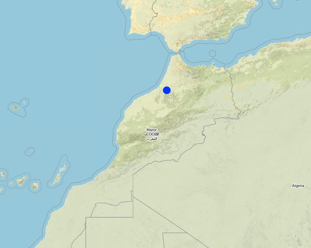
2.5 Country/ region/ locations where the Technology has been applied and which are covered by this assessment
Country:
Morocco
Region/ State/ Province:
Sehoul, Rabat region
Further specification of location:
Salé province
Map
×2.6 Date of implementation
If precise year is not known, indicate approximate date:
- less than 10 years ago (recently)
2.7 Introduction of the Technology
Specify how the Technology was introduced:
- during experiments/ research
- through projects/ external interventions
Comments (type of project, etc.):
The technology was introduced as an experiment, in the context of a research project which started 5 years ago; it was recommended by the local stakeholders during participatory process. The experiment tries to confirm the ability to plantation of fodder shrubs in a fenced plot to increase biomass and biodiversity and reduce the erosion process of gullying.
3. Classification of the SLM Technology
3.2 Current land use type(s) where the Technology is applied

Grazing land
Extensive grazing land:
- Semi-nomadism/ pastoralism

Mixed (crops/ grazing/ trees), incl. agroforestry
Comments:
Major land use problems (compiler’s opinion): Retreat and degradation of the vegetation cover, degradation of soil quality, development of signs of water erosion, namely rills and on some slopes gullies with rapid extension. Progressive expansion of abandoned lands not recolonized by vegetation, which create patches of desertified land in the area.
Major land use problems (land users’ perception): Decrease in yield, decrease in the availability of water and of its level in wells.
Semi-nomadism / pastoralism: Small movements to the nearby forest
Forest products and services: fuelwood, grazing / browsing, other forest products / uses (honey, medical, etc.)
Future (final) land use (after implementation of SLM Technology): Grazing land: Gi: Intensive grazing/ fodder production
If land use has changed due to the implementation of the Technology, indicate land use before implementation of the Technology:
Grazing land: Ge: Extensive grazing land
3.3 Further information about land use
Water supply for the land on which the Technology is applied:
- mixed rainfed-irrigated
Number of growing seasons per year:
- 1
Specify:
Longest growing period in days: 210
Longest growing period from month to month: September to April
Livestock density (if relevant):
25-50 LU /km2
3.5 Spread of the Technology
Comments:
Total area covered by the SLM Technology is 0.005 m2.
The technology is an experimental action, in the framework of a research project
3.6 SLM measures comprising the Technology

agronomic measures
- A1: Vegetation/ soil cover

vegetative measures
- V1: Tree and shrub cover

structural measures
- S4: Level ditches, pits

management measures
- M2: Change of management/ intensity level
Comments:
Main measures: vegetative measures
Secondary measures: management measures
Type of vegetative measures: aligned: -contour
3.7 Main types of land degradation addressed by the Technology

soil erosion by water
- Wg: gully erosion/ gullying
Comments:
Main type of degradation addressed: Wg: gully erosion / gullying
Main causes of degradation: overgrazing (The animal pressure increased recently, due to association between the local inhabitants and investors from the city), disturbance of water cycle (infiltration / runoff) (The overgrazing on degraded soils leads to decrease of permebility and then less infiltration to the water table), other human induced causes (specify) (The degraded lands are abandoned and this leads to the continuous extension and more deep incisions of gullies), change of seasonal rainfall (The irregularity of rain is a factor of degradation), Heavy / extreme rainfall (intensity/amounts) (The intensity of rain can be a major factor of impact on the soils), land tenure (the extensive grazing is based on the principle of free displacement of flocks), poverty / wealth (The social level of population explains the need to over-exploitation of natural resources), education, access to knowledge and support services (Lack of conscience), attractiveness of cities (The proximity of cities explains the attirance of those spaces on the population (opportunities for jobs))
Secondary causes of degradation: soil management (The cereal use during years degraded the soils which became poor with a weak yield and fragile against processes of erosion), deforestation / removal of natural vegetation (incl. forest fires) (The clearing of forest was flollowed by a crop use which doesn't offer to the soils the same protection and doesn't feed them with organic matter), droughts (The dry years have an occurrence of 1/2 and can be a factor of abandon of lands), population pressure (This factor is not very important in this area because the trend is for a stability of the population)
3.8 Prevention, reduction, or restoration of land degradation
Specify the goal of the Technology with regard to land degradation:
- reduce land degradation
- restore/ rehabilitate severely degraded land
Comments:
Main goals: rehabilitation / reclamation of denuded land
Secondary goals: mitigation / reduction of land degradation
4. Technical specifications, implementation activities, inputs, and costs
4.1 Technical drawing of the Technology
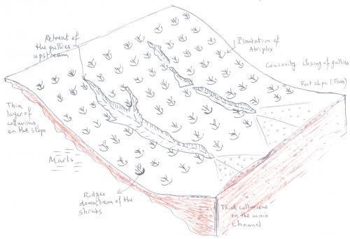
Author:
Abdellah Laouina, Univ. Mohammed V, BP 1040, Rabat
4.2 Technical specifications/ explanations of technical drawing
The drawing shows a slope eroded by parallel gullies. The incision develops in colluvial red material. Downstream, the gullies deposit the transported material and deposit it in the form of large fans made of pebbles washed by water which transports the fine elements to the main channel and to the Grou valley. The technology consists in the plantation of Atriplex shrubs planted along the contours. The small ridges on the downstream side of the shrubs and the shrubs themselves retain water and improve infiltration, which creates better conditions for growing grass.
Location: Hannanet catchment. Sehoul, Province of Rabat-Salé
Date: 20-09-2011
Technical knowledge required for field staff / advisors: low (The plantation doesn't require ahigh degree of experience)
Technical knowledge required for land users: moderate (This technique is new for the local population and requires some conscience of the problem of land degradation)
Main technical functions: control of dispersed runoff: retain / trap, control of dispersed runoff: impede / retard, control of concentrated runoff: retain / trap, control of concentrated runoff: impede / retard, improvement of ground cover, increase of surface roughness, stabilisation of soil (eg by tree roots against land slides), increase of infiltration, promotion of vegetation species and varieties (quality, eg palatable fodder)
Secondary technical functions: control of raindrop splash, improvement of surface structure (crusting, sealing), improvement of topsoil structure (compaction), increase in organic matter, increase / maintain water stored in soil, increase of groundwater level / recharge of groundwater, sediment retention / trapping, sediment harvesting, reduction in wind speed, increase of biomass (quantity)
Aligned: -contour
Vegetative material: T : trees / shrubs
Number of plants per (ha): 760
Vertical interval between rows / strips / blocks (m): 6
Spacing between rows / strips / blocks (m): 4
Vertical interval within rows / strips / blocks (m): 6
Width within rows / strips / blocks (m): 4
Trees/ shrubs species: atriplex halimus
Slope (which determines the spacing indicated above): 15%
Gradient along the rows / strips: 15%
Change of land use practices / intensity level: better fodder availability and intensification
Major change in timing of activities: 2 years of non grazing, due to fencing and opening after the 2 years
Control / change of species composition: control of grazing pression
4.3 General information regarding the calculation of inputs and costs
other/ national currency (specify):
dirham
Indicate exchange rate from USD to local currency (if relevant): 1 USD =:
8.0
Indicate average wage cost of hired labour per day:
31.25
4.4 Establishment activities
| Activity | Type of measure | Timing | |
|---|---|---|---|
| 1. | Digging Holes: 40 * 40 * 40 cm | Vegetative | april 2009 |
| 2. | Wood stakes and hole drilling | Vegetative | April 2009 |
| 3. | Plantation | Vegetative | april 2009 |
| 4. | Irrigation | Management | April 2009 |
| 5. | Fencing | Management | April 2009 |
4.5 Costs and inputs needed for establishment
| Specify input | Unit | Quantity | Costs per Unit | Total costs per input | % of costs borne by land users | |
|---|---|---|---|---|---|---|
| Labour | Digging a hole | times | 760.0 | 0.74 | 562.4 | |
| Labour | Planting in a hole | times | 760.0 | 1.48026 | 1125.0 | |
| Labour | Irrigation | person days | 12.0 | 31.25 | 375.0 | |
| Construction material | Wood | ha | 1.0 | 205.0 | 205.0 | |
| Construction material | Metallic fence | ha | 1.0 | 650.0 | 650.0 | |
| Other | Water | m3 | 80.0 | 6.25 | 500.0 | |
| Total costs for establishment of the Technology | 3417.4 | |||||
Comments:
Duration of establishment phase: 12 month(s)
4.7 Costs and inputs needed for maintenance/ recurrent activities (per year)
Comments:
citerne à eaux, pioche, citerne à eau, pioche.
coût par rapport à l'hectare travaillé
4.8 Most important factors affecting the costs
Describe the most determinate factors affecting the costs:
The cost is determinated by the amount of work necessary for plantation and fencing the plots
5. Natural and human environment
5.1 Climate
Annual rainfall
- < 250 mm
- 251-500 mm
- 501-750 mm
- 751-1,000 mm
- 1,001-1,500 mm
- 1,501-2,000 mm
- 2,001-3,000 mm
- 3,001-4,000 mm
- > 4,000 mm
Agro-climatic zone
- semi-arid
Thermal climate class: subtropics. Mediterranean semi-arid climate with temperate winter
5.2 Topography
Slopes on average:
- flat (0-2%)
- gentle (3-5%)
- moderate (6-10%)
- rolling (11-15%)
- hilly (16-30%)
- steep (31-60%)
- very steep (>60%)
Landforms:
- plateau/plains
- ridges
- mountain slopes
- hill slopes
- footslopes
- valley floors
Altitudinal zone:
- 0-100 m a.s.l.
- 101-500 m a.s.l.
- 501-1,000 m a.s.l.
- 1,001-1,500 m a.s.l.
- 1,501-2,000 m a.s.l.
- 2,001-2,500 m a.s.l.
- 2,501-3,000 m a.s.l.
- 3,001-4,000 m a.s.l.
- > 4,000 m a.s.l.
5.3 Soils
Soil depth on average:
- very shallow (0-20 cm)
- shallow (21-50 cm)
- moderately deep (51-80 cm)
- deep (81-120 cm)
- very deep (> 120 cm)
Soil texture (topsoil):
- coarse/ light (sandy)
- medium (loamy, silty)
Topsoil organic matter:
- medium (1-3%)
- low (<1%)
5.4 Water availability and quality
Ground water table:
5-50 m
Water quality (untreated):
good drinking water
5.5 Biodiversity
Species diversity:
- low
5.6 Characteristics of land users applying the Technology
Off-farm income:
- 10-50% of all income
Relative level of wealth:
- average
Individuals or groups:
- individual/ household
Gender:
- men
Indicate other relevant characteristics of the land users:
Land users applying the Technology are mainly Leaders / privileged
Population density: 10-50 persons/km2
Annual population growth: < 0.5%
25% of the land users are average wealthy and own 12% of the land.
5.7 Average area of land owned or leased by land users applying the Technology
- < 0.5 ha
- 0.5-1 ha
- 1-2 ha
- 2-5 ha
- 5-15 ha
- 15-50 ha
- 50-100 ha
- 100-500 ha
- 500-1,000 ha
- 1,000-10,000 ha
- > 10,000 ha
Is this considered small-, medium- or large-scale (referring to local context)?
- medium-scale
5.8 Land ownership, land use rights, and water use rights
Land ownership:
- individual, titled
- in association
Land use rights:
- open access (unorganized)
Water use rights:
- open access (unorganized)
Comments:
le mode dominant est le melk (la propriété privée) suivi de l'association
5.9 Access to services and infrastructure
health:
- poor
- moderate
- good
education:
- poor
- moderate
- good
technical assistance:
- poor
- moderate
- good
employment (e.g. off-farm):
- poor
- moderate
- good
markets:
- poor
- moderate
- good
energy:
- poor
- moderate
- good
roads and transport:
- poor
- moderate
- good
drinking water and sanitation:
- poor
- moderate
- good
financial services:
- poor
- moderate
- good
6. Impacts and concluding statements
6.1 On-site impacts the Technology has shown
Socio-economic impacts
Production
fodder production
Quantity before SLM:
1600kg/ha
Quantity after SLM:
6200kg/ha
fodder quality
Quantity before SLM:
127 UF/ha
Quantity after SLM:
694 UF/ha
production area
land management
Income and costs
farm income
workload
Socio-cultural impacts
national institutions
SLM/ land degradation knowledge
Ecological impacts
Soil
soil moisture
Quantity before SLM:
< 4% TDR
Quantity after SLM:
7-8% TDR
soil cover
Quantity before SLM:
42% cover
Quantity after SLM:
88% cover
soil compaction
Quantity before SLM:
5kg/m²
Quantity after SLM:
4kg/m²
Biodiversity: vegetation, animals
biomass/ above ground C
Quantity before SLM:
1600kg/ha
Quantity after SLM:
6200kg/ha
plant diversity
Quantity before SLM:
10 sp/m²
Quantity after SLM:
27 sp/m²
6.2 Off-site impacts the Technology has shown
downstream flooding
downstream siltation
damage on neighbours' fields
6.3 Exposure and sensitivity of the Technology to gradual climate change and climate-related extremes/ disasters (as perceived by land users)
Gradual climate change
Gradual climate change
| Season | Type of climatic change/ extreme | How does the Technology cope with it? | |
|---|---|---|---|
| annual temperature | increase | well |
Climate-related extremes (disasters)
Meteorological disasters
| How does the Technology cope with it? | |
|---|---|
| local rainstorm | not known |
| local windstorm | not well |
Climatological disasters
| How does the Technology cope with it? | |
|---|---|
| drought | well |
Hydrological disasters
| How does the Technology cope with it? | |
|---|---|
| general (river) flood | well |
6.4 Cost-benefit analysis
How do the benefits compare with the establishment costs (from land users’ perspective)?
Short-term returns:
slightly negative
Long-term returns:
very positive
How do the benefits compare with the maintenance/ recurrent costs (from land users' perspective)?
Short-term returns:
neutral/ balanced
Long-term returns:
slightly positive
Comments:
The outputs could be really positive after at least 7 years
6.5 Adoption of the Technology
Comments:
1 land user families have adopted the Technology with external material support
Comments on acceptance with external material support: The technique was in the framework of an experimentation
There is no trend towards spontaneous adoption of the Technology
6.7 Strengths/ advantages/ opportunities of the Technology
| Strengths/ advantages/ opportunities in the land user’s view |
|---|
|
Availability of fodder when the plots are opened to grazing How can they be sustained / enhanced? temporary fencing when necessary |
| Strengths/ advantages/ opportunities in the compiler’s or other key resource person’s view |
|---|
|
Rehabilitation of degraded land How can they be sustained / enhanced? engagement of the government in subsidizing part of the inputs and in creating awareness among the people to maintain the technology |
|
Change in land cover by vegetation How can they be sustained / enhanced? temporary fencing when necessary |
|
Change in hydrological behaviour of the surface and improved water balance on- and off-site How can they be sustained / enhanced? maintain vegetation cover |
|
Improvement of the fodder quality and quantity How can they be sustained / enhanced? temporary fencing when necessary, enrichment of herbs by controlling the grazing period and number of animals |
|
Less loss of land (due to gullies) and reduced risk of erosion How can they be sustained / enhanced? expand technology and maintain vegetation cover, planting of other shrubs, such as Cactus opuntia to control gully incision |
6.8 Weaknesses/ disadvantages/ risks of the Technology and ways of overcoming them
| Weaknesses/ disadvantages/ risks in the land user’s view | How can they be overcome? |
|---|---|
| Non-grazing due to fences during a 2 year period | rotation between grazing plots |
| la réduction(pendant la période de la mise endéfens) de la superficie allouée à la vaine pâture |
| Weaknesses/ disadvantages/ risks in the compiler’s or other key resource person’s view | How can they be overcome? |
|---|---|
| High costs of implementation | government to subsidize part of the inputs |
7. References and links
7.2 References to available publications
Title, author, year, ISBN:
Antari M. (2007) : Mesure de l’érosion et du ruissemellent dans le micro-bassin versant Matlaq et essai de modélisation (Région de Rabat, Maroc). Thèse de Doctorat, Université Mohammed V-Agdal, Faculté des Lettres et Science Humaines, Rabat. 218p.
Available from where? Costs?
Bibliothèque de la Faculté des Lettres et Science Humaines, Rabat, Maroc
Title, author, year, ISBN:
Nafaa R. (1997) : Dynamique du milieu naturel de la Mamora : paléoenvironnements et évolution actuelle de la surface. Thèse d’Etat en géographie physique, FLSH Rabat, 275p
Available from where? Costs?
Bibliothèque de la Faculté des Lettres et Science Humaines, Rabat, Maroc
Title, author, year, ISBN:
Ghanem H. (1981) : Contribution à la connaissance des sols du Maroc. Genèse et répartition des sols des régions des Zaers, de la basse Chaouia et des Shouls (Méséta marocaine). Cahiers de la Recherche Agronomique n°37&38, INRA, Rabat.
Available from where? Costs?
Bibliothèque de la Faculté des Lettres et Science Humaines, Rabat, Maroc
Title, author, year, ISBN:
DPA (2001) : Projet de mise en valeur bour des Shouls. Direction Provinciale de l’Agriculture, Rabat.
Available from where? Costs?
Direction Provinciale de l’Agriculture, Rabat
Title, author, year, ISBN:
DPA (2002): Étude de l’analyse des sols dans le périmètre de mise en valeur en bour des Shouls. Evaluation de la fertilité des sols et fertilisation des cultures. Marché négocié 01-2002-DPA-36.
Available from where? Costs?
Direction Provinciale de l’Agriculture, Rabat
Links and modules
Expand all Collapse allLinks
No links
Modules
No modules