Reduced tillage: no tillage in autumn [Norway]
- Creation:
- Update:
- Compiler: Kamilla Skaalsveen
- Editors: Dominika Krzeminska, Lillian Øygarden
- Reviewers: Alexandra Gavilano, William Critchley, Rima Mekdaschi Studer
Redusert jordarbeiding - ingen jordarbeiding om høsten
technologies_1245 - Norway
View sections
Expand all Collapse all1. General information
1.2 Contact details of resource persons and institutions involved in the assessment and documentation of the Technology
Key resource person(s)
SLM specialist:
SLM specialist:
Bechmann Marianne
NIBIO
Norway
SLM specialist:
SLM specialist:
1.3 Conditions regarding the use of data documented through WOCAT
The compiler and key resource person(s) accept the conditions regarding the use of data documented through WOCAT:
Yes
1.4 Declaration on sustainability of the described Technology
Is the Technology described here problematic with regard to land degradation, so that it cannot be declared a sustainable land management technology?
No
1.5 Reference to Questionnaire(s) on SLM Approaches (documented using WOCAT)

Regional Environmental program [Norway]
Regulations and financial grants for reduction of pollution and promotion of the cultural landscape.
- Compiler: Kamilla Skaalsveen
2. Description of the SLM Technology
2.1 Short description of the Technology
Definition of the Technology:
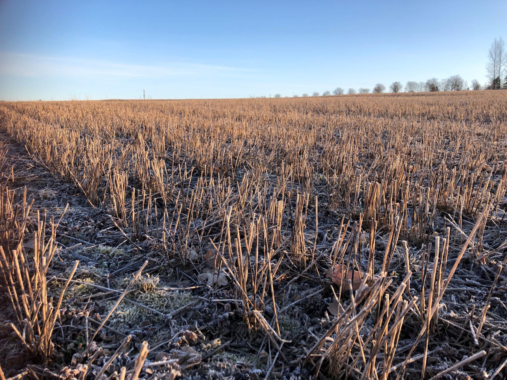
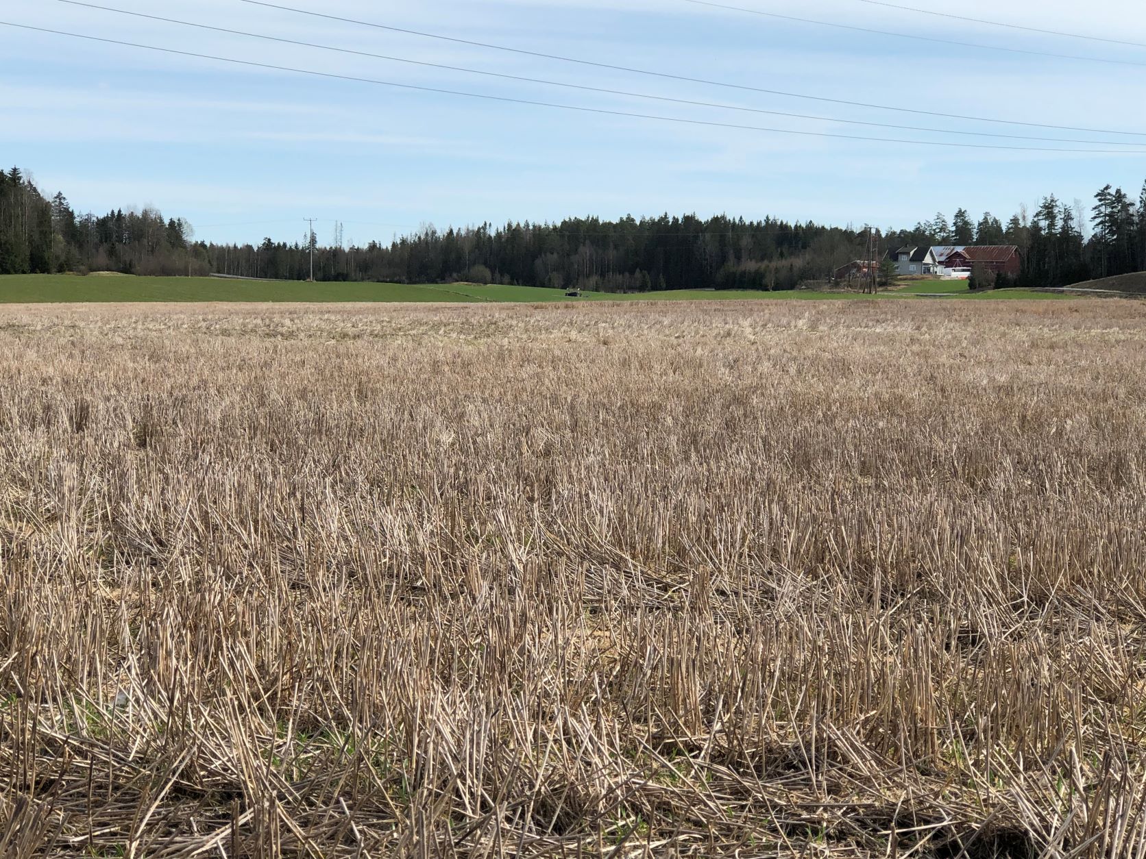
Reduced tillage, involving no plowing in the autumn, preserves stubble or plant cover during the autumn and winter to prevent soil erosion, and particle and nutrient loss from cropland to watercourses.
2.2 Detailed description of the Technology
Description:
Purpose/aim: Reduced tillage (i.e., no tillage in autumn) is an efficient measure of preventing soil erosion, and particle and nutrient loss from cropland to watercourses. In addition to the protection of soil from water erosion, stubble fields contribute to increasing organic matter content, which may also increase the aggregate stability of the soil (in the upper soil layers). It is also possible that, as a result of this measure, higher biological activity may improve the soil structure.
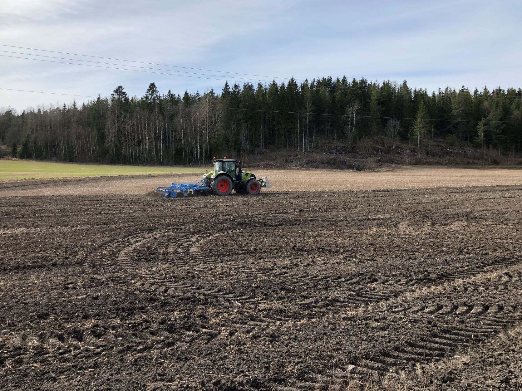
Establishment/Maintenance: No tillage in autumn means that cropland areas are left as stubble fields after the harvesting is carried out and they remain like this throughout the winter.
It is of importance to keep in mind the potential for increased amounts of weeds and diseases (incl. fungi) when practicing this measure. The soil may also develop a rather dense structure over time if the climate is humid.
Natural / human environment: The information about Technology is based on the investigations and/or reports from different part of Norway.
For the purpose of the OPTAIN project (https://www.optain.eu/), the technology is further presented in the natural and human environment context of the Kråkstad River catchment - a Norwegian Case Study catchment within OPTAIN project.
The Kråkstad River is mainly situated in Ski municipality in South-Eastern parts of Norway. The river catchment is a western tributary of the Vansjø-Hobøl watercourse, also known as the Morsa watercourse. The Kråkstad River catchment area is c.a 51 km², 43% of which is agricultural land, where mostly cereals are produced on heavy clays soils. The main environmental challenge in the area is water quality (incl. high phosphorus pollution) and soil erosion (incl. riverbank erosion and quick-clay landslides). The Morsa watercourse is a drinking water resource and there are specific environmental regulations for land management followed by subsidies through the Regional Environmental Programme (RMP).
Special regulations in the Morsa catchment (https://morsa.org/) recommend that tillage, and fertilizer additions, are postponed to the start of March at the earliest.
2.3 Photos of the Technology
Media Gallery
2.5 Country/ region/ locations where the Technology has been applied and which are covered by this assessment
Country:
Norway
Region/ State/ Province:
Viken county
Further specification of location:
The Vansjø - Hobøl catchment
Specify the spread of the Technology:
- evenly spread over an area
If precise area is not known, indicate approximate area covered:
- 10-100 km2
Is/are the technology site(s) located in a permanently protected area?
No
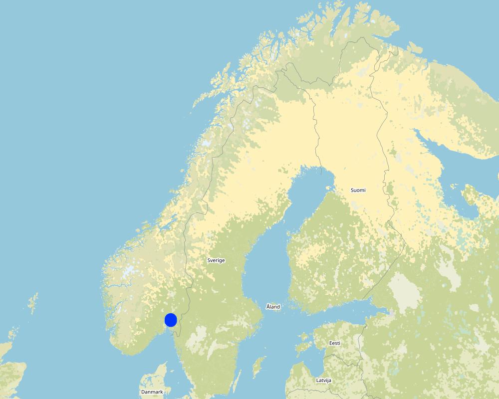
Map
×2.6 Date of implementation
If precise year is not known, indicate approximate date:
- 10-50 years ago
2.7 Introduction of the Technology
Specify how the Technology was introduced:
- through projects/ external interventions
- Regional Environmental Programme (RMP)
Comments (type of project, etc.):
The traditional soil tillage method until 1990 was autumn ploughing. From 1991 subsidies (RMP) were given for reduced autumn tillage and during the
period from 1990 to 2002 the autumn ploughed area was reduced from 82% to 43% of the cereal area (Bechmann, 2015). In 2009 about 53% of the grain area
was tilled in spring (Snellingen-Bye et al., 2010). In 2019 about 42% of the grain area was left in stubble during winter (Bjørlo et al. 2021).
Reference:
Bechmann, M., Collentine, D., Gertz, F., Graversgaard, M., Hasler, B., Helin, J., Jacobsen, B., Rankinen, K. and Refsgaard, K. 2016 Water management for agriculture in the nordic countries. Background document for NJF seminar 487. NIBIO report 2/2/2016.
Snellingen, Bye, A. and Løvberget, A. 2010. Landbruksteljing 2010. Statistisk sentralbyrå Rapport 2014/5.
3. Classification of the SLM Technology
3.1 Main purpose(s) of the Technology
- reduce, prevent, restore land degradation
- protect a watershed/ downstream areas – in combination with other Technologies
- adapt to climate change/ extremes and its impacts
3.2 Current land use type(s) where the Technology is applied
Land use mixed within the same land unit:
No

Cropland
- Annual cropping
Annual cropping - Specify crops:
- cereals - other
- small grains
Number of growing seasons per year:
- 1
Specify:
Longest growing period in days: 135Longest growing period from month to month: May 1 to mid-September
3.3 Has land use changed due to the implementation of the Technology?
Has land use changed due to the implementation of the Technology?
- No (Continue with question 3.4)
3.4 Water supply
Water supply for the land on which the Technology is applied:
- rainfed
3.5 SLM group to which the Technology belongs
- minimal soil disturbance
3.6 SLM measures comprising the Technology

agronomic measures
- A1: Vegetation/ soil cover
- A2: Organic matter/ soil fertility
- A3: Soil surface treatment
A3: Differentiate tillage systems:
A 3.2: Reduced tillage (> 30% soil cover)
Comments:
Main measures: agronomic measures
Type of agronomic measures: minimum tillage
3.7 Main types of land degradation addressed by the Technology

soil erosion by water
- Wt: loss of topsoil/ surface erosion
- Wg: gully erosion/ gullying

water degradation
- Hp: decline of surface water quality
Comments:
Main type of degradation addressed: Wt: loss of topsoil / surface erosion
Secondary types of degradation addressed: Wg: gully erosion / gullying, Hp: decline of surface water quality
Main causes of degradation: soil management, heavy / extreme rainfall (intensity/amounts), governance / institutional
Secondary causes of degradation: deforestation / removal of natural vegetation (incl. forest fires), disturbance of water cycle (infiltration / runoff), change of seasonal rainfall, floods, land tenure
3.8 Prevention, reduction, or restoration of land degradation
Specify the goal of the Technology with regard to land degradation:
- prevent land degradation
- reduce land degradation
Comments:
Main goals: prevention of land degradation
Secondary goals: mitigation / reduction of land degradation
4. Technical specifications, implementation activities, inputs, and costs
4.1 Technical drawing of the Technology
Technical specifications (related to technical drawing):
not available
4.2 General information regarding the calculation of inputs and costs
Specify how costs and inputs were calculated:
- per Technology area
Indicate size and area unit:
daa of arable land
If using a local area unit, indicate conversion factor to one hectare (e.g. 1 ha = 2.47 acres): 1 ha =:
10 daa
other/ national currency (specify):
NOK
If relevant, indicate exchange rate from USD to local currency (e.g. 1 USD = 79.9 Brazilian Real): 1 USD =:
8.89
Indicate average wage cost of hired labour per day:
1440
4.3 Establishment activities
| Activity | Timing (season) | |
|---|---|---|
| 1. | no tillage in autumn | autumn |
Comments:
No initial investment
4.4 Costs and inputs needed for establishment
Comments:
No initial investments
4.5 Maintenance/ recurrent activities
| Activity | Timing/ frequency | |
|---|---|---|
| 1. | no tillage in autumn | autumn |
4.6 Costs and inputs needed for maintenance/ recurrent activities (per year)
If land user bore less than 100% of costs, indicate who covered the remaining costs:
Under the RMP system (Regional Environmental Programme ) farmers can apply for subsidies for changed tillage practices. The subsidies are paid after erosion risk class.
Comments:
The measure does not lead to any additional expenses for the land user.
However, land users indicate the need for consequent Increased usage of pesticides and reduced production. Subsidies for reduced tillage should compensate for negative effects and costs.
4.7 Most important factors affecting the costs
Describe the most determinate factors affecting the costs:
The measure does not lead to any additional expenses for the land user.However, land users indicate the need for consequent Increased usage of pesticides and reduced production.
Under the RMP system (Regional Environmental Programme in agriculture) farmers can apply for subsidies for changed tillage practices. The level of subsidy are based on erosion risk of the area. Depending on erosion risk class, farmer is entitled to ca. 20-200 kr/daa when implementing reduced autumn tillage (RMP for 2019-2022). In exposed watersheds, like those used for drinking water supply (e, g Vansjø- Hobøl catchment) farmers are obliged to implement stricter management practices to receive production support. The farmers in these catchments get higher subsidies than those in other catchments (Bechmann et al. 2016)
5. Natural and human environment
5.1 Climate
Annual rainfall
- < 250 mm
- 251-500 mm
- 501-750 mm
- 751-1,000 mm
- 1,001-1,500 mm
- 1,501-2,000 mm
- 2,001-3,000 mm
- 3,001-4,000 mm
- > 4,000 mm
Specify average annual rainfall (if known), in mm:
829.00
Specifications/ comments on rainfall:
The mean annual precipitation in Hobøl catchment is 829 mm (e.g., Skarbøvik and Bechmann, 2010). Large differences in water discharge are observed at the Hobøl River (Skarbøvik et al., 2014): from relatively stable discharge (1.0–3.0 m3/s) in winter and summer periods, to dynamically changing high discharge (7.0–48.0 m3/s) in spring and autumn.
Agro-climatic zone
- sub-humid
- semi-arid
Thermal climate class: temperate
Thermal climate class: boreal
5.2 Topography
Slopes on average:
- flat (0-2%)
- gentle (3-5%)
- moderate (6-10%)
- rolling (11-15%)
- hilly (16-30%)
- steep (31-60%)
- very steep (>60%)
Landforms:
- plateau/plains
- ridges
- mountain slopes
- hill slopes
- footslopes
- valley floors
Altitudinal zone:
- 0-100 m a.s.l.
- 101-500 m a.s.l.
- 501-1,000 m a.s.l.
- 1,001-1,500 m a.s.l.
- 1,501-2,000 m a.s.l.
- 2,001-2,500 m a.s.l.
- 2,501-3,000 m a.s.l.
- 3,001-4,000 m a.s.l.
- > 4,000 m a.s.l.
5.3 Soils
Soil depth on average:
- very shallow (0-20 cm)
- shallow (21-50 cm)
- moderately deep (51-80 cm)
- deep (81-120 cm)
- very deep (> 120 cm)
Soil texture (topsoil):
- medium (loamy, silty)
- fine/ heavy (clay)
Soil texture (> 20 cm below surface):
- medium (loamy, silty)
- fine/ heavy (clay)
Topsoil organic matter:
- medium (1-3%)
If available, attach full soil description or specify the available information, e.g. soil type, soil PH/ acidity, Cation Exchange Capacity, nitrogen, salinity etc.
Soil fertility is medium-high
Soil drainage/infiltration is poor, need artificial drainage
Soil water storage capacity is very low-low
5.4 Water availability and quality
Ground water table:
< 5 m
Availability of surface water:
good
Water quality (untreated):
for agricultural use only (irrigation)
Water quality refers to:
both ground and surface water
Is water salinity a problem?
No
Is flooding of the area occurring?
Yes
5.5 Biodiversity
Species diversity:
- low
Habitat diversity:
- low
5.6 Characteristics of land users applying the Technology
Sedentary or nomadic:
- Sedentary
Market orientation of production system:
- mixed (subsistence/ commercial)
- commercial/ market
Off-farm income:
- > 50% of all income
Relative level of wealth:
- average
- rich
Individuals or groups:
- individual/ household
Level of mechanization:
- mechanized/ motorized
Gender:
- women
- men
Age of land users:
- youth
- middle-aged
Indicate other relevant characteristics of the land users:
Land users applying the Technology are mainly common / average land users
Population density: < 10 persons/km2
Annual population growth: < 0.5%
10% of the land users are rich and own 10% of the land.
90% of the land users are average wealthy and own 90% of the land.
5.7 Average area of land used by land users applying the Technology
- < 0.5 ha
- 0.5-1 ha
- 1-2 ha
- 2-5 ha
- 5-15 ha
- 15-50 ha
- 50-100 ha
- 100-500 ha
- 500-1,000 ha
- 1,000-10,000 ha
- > 10,000 ha
Is this considered small-, medium- or large-scale (referring to local context)?
- medium-scale
5.8 Land ownership, land use rights, and water use rights
Land ownership:
- individual, titled
Land use rights:
- individual
Water use rights:
- open access (unorganized)
5.9 Access to services and infrastructure
health:
- poor
- moderate
- good
education:
- poor
- moderate
- good
technical assistance:
- poor
- moderate
- good
employment (e.g. off-farm):
- poor
- moderate
- good
markets:
- poor
- moderate
- good
energy:
- poor
- moderate
- good
roads and transport:
- poor
- moderate
- good
drinking water and sanitation:
- poor
- moderate
- good
financial services:
- poor
- moderate
- good
6. Impacts and concluding statements
6.1 On-site impacts the Technology has shown
Socio-economic impacts
Production
crop production
Comments/ specify:
There is a potential for increased amounts of weeds and diseases (incl. fungi) when practicing this measure.
risk of production failure
land management
Income and costs
farm income
Comments/ specify:
Subsidies should compensate some costs
workload
Socio-cultural impacts
SLM/ land degradation knowledge
Improved livelihoods and human well-being
Ecological impacts
Water cycle/ runoff
water quality
surface runoff
evaporation
Soil
soil cover
soil loss
soil compaction
Comments/ specify:
The soil may also develop a rather dense structure over time if the climate is humid.
Biodiversity: vegetation, animals
biomass/ above ground C
beneficial species
6.2 Off-site impacts the Technology has shown
downstream flooding
downstream siltation
damage on public/ private infrastructure
Specify assessment of off-site impacts (measurements):
Major land use problems (compiler’s opinion): Erosion, flooding and landslides, eutrophication of rivers and lakes
Major land use problems (land users’ perception): Increased usage of pesticides and reduced production
6.3 Exposure and sensitivity of the Technology to gradual climate change and climate-related extremes/ disasters (as perceived by land users)
Gradual climate change
Gradual climate change
| Season | increase or decrease | How does the Technology cope with it? | |
|---|---|---|---|
| annual temperature | increase | well | |
| seasonal rainfall | autumn | increase | well |
Climate-related extremes (disasters)
Meteorological disasters
| How does the Technology cope with it? | |
|---|---|
| local rainstorm | well |
| local windstorm | well |
Climatological disasters
| How does the Technology cope with it? | |
|---|---|
| drought | well |
Hydrological disasters
| How does the Technology cope with it? | |
|---|---|
| general (river) flood | well |
Other climate-related consequences
Other climate-related consequences
| How does the Technology cope with it? | |
|---|---|
| extended growing period | well |
6.4 Cost-benefit analysis
How do the benefits compare with the maintenance/ recurrent costs (from land users' perspective)?
Short-term returns:
slightly negative
Long-term returns:
slightly negative
Comments:
There are no establishment costs.
Subsidies paid after erosion risk are supposed to cover for negative effects and costs for maintenance (e.g for increased pesticide use, lower yield )
6.5 Adoption of the Technology
- 11-50%
Of all those who have adopted the Technology, how many did so spontaneously, i.e. without receiving any material incentives/ payments?
- 0-10%
Comments:
There is no trend towards spontaneous adoption of the Technology.
Local regulations determine that farmers only receive subsidies per production area along with financial grants if they implement the technology.
6.6 Adaptation
Has the Technology been modified recently to adapt to changing conditions?
No
6.7 Strengths/ advantages/ opportunities of the Technology
| Strengths/ advantages/ opportunities in the land user’s view |
|---|
| Reduced soil loss and erosion |
| Strengths/ advantages/ opportunities in the compiler’s or other key resource person’s view |
|---|
| Reduced soil loss and erosion |
| Reduced eutrophication of rivers and lakes |
6.8 Weaknesses/ disadvantages/ risks of the Technology and ways of overcoming them
| Weaknesses/ disadvantages/ risks in the land user’s view | How can they be overcome? |
|---|---|
| Increased usage of pesticides | |
| Reduced production |
| Weaknesses/ disadvantages/ risks in the compiler’s or other key resource person’s view | How can they be overcome? |
|---|---|
| Higher demand for pesticides | Autumn and spring harrowing |
7. References and links
7.1 Methods/ sources of information
- compilation from reports and other existing documentation
When were the data compiled (in the field)?
07/02/2022
7.2 References to available publications
Title, author, year, ISBN:
Water management for agriculture in the nordic contries. Bechmann et al. 2016. NIBIO report 2/2/2016
Available from where? Costs?
www.nibio.no
Title, author, year, ISBN:
Norwegian policy and practices regarding mitigation measures in agriculture. 2016. NIBIO POP 2(21) 2016.
Available from where? Costs?
www.nibio.no
Title, author, year, ISBN:
Soil Tillage and Crop Growth Effects on Surface and Subsurface Runoff, Loss of Soil, Phosphorus and Nitrogen in a Cold Climate. Benchmann and Bøe 2021. Land 2021, 10(1), 77
Available from where? Costs?
https://www.mdpi.com/
7.3 Links to relevant online information
Title/ description:
Water management for agriculture in the nordic contries. Bechmann et al. 2016. NIBIO report 2/2/2016
URL:
https://nibio.brage.unit.no/nibio-xmlui/handle/11250/2382641
Title/ description:
Norwegian policy and practices regarding mitigation measures in agriculture. 2016. NIBIO POP 2(21) 2016.
URL:
https://nibio.brage.unit.no/nibio-xmlui/bitstream/handle/11250/2387569/NIBIO_POP_2016_2_21.pdf?sequence=3&isAllowed=y
Title/ description:
Soil Tillage and Crop Growth Effects on Surface and Subsurface Runoff, Loss of Soil, Phosphorus and Nitrogen in a Cold Climate. Bechmann and Bøe 2021. Land 2021, 10(1), 77
URL:
https://www.mdpi.com/2073-445X/10/1/77
7.4 General comments
no remarks
Links and modules
Expand all Collapse allLinks
Regional Environmental program [Norway]
Regulations and financial grants for reduction of pollution and promotion of the cultural landscape.
- Compiler: Kamilla Skaalsveen
Modules
No modules