Runoff/floodwater farming [Ethiopia]
- Creation:
- Update:
- Compiler: Daniel Danano
- Editor: –
- Reviewer: Alexandra Gavilano
Korbe (Oromifa)
technologies_943 - Ethiopia
View sections
Expand all Collapse all1. General information
1.3 Conditions regarding the use of data documented through WOCAT
The compiler and key resource person(s) accept the conditions regarding the use of data documented through WOCAT:
Yes
2. Description of the SLM Technology
2.1 Short description of the Technology
Definition of the Technology:
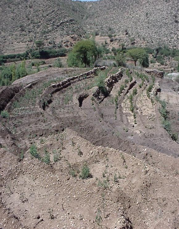
Runoff/flood farming locally known as Korbe is a practice that involves diversion of water from different sources for growing vegetables, fruit trees and crops of high value on a land prepared known as Korbe.
2.2 Detailed description of the Technology
Description:
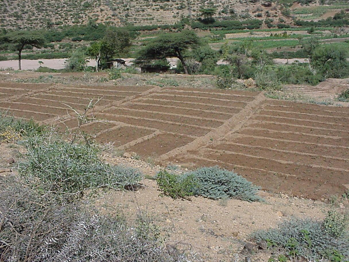
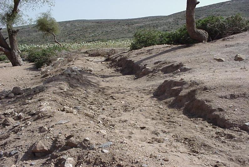
Runoff and floodwater farming is a traditionally practiced water harvesting system which helps overcome problems of soil moisture and crop failure in a hot, dry area with erratic rainfall and shallow, highly erodible soils: Flood water and runoff from ephemeral rivers, roads and hillsides is captured through temporary stone and earth embankments. A system of hand dug canals – consisting of a main diversion canal and secondary / tertiary canals – conveys and distributes the captured water to the cultivated fields in naturally flat or leveled areas. The total length of the canal system is 200 – 2000 m. The harvested water is used for growing high value crops, vegetables and fruit trees. Irrigated fields are divided into rectangular basins bordered by ridges to maximize water storage and minimize erosion risk.
Runoff and floodwater management requires preparedness for immediate action by the farmers: When a flood is expected in the ephemeral river, farmers rush to the diversion site and start erecting the embankment across the bed of the stream. Similarly, each famer starts to maintain the canal which leads water to his field. A schedule defines the date and time each farmer is allocated his turn to irrigate. When the water reaches the field, it is spread either through flooding or distributed in furrows which are opened and closed using a local tool.
The ratio between catchment area and production area is 10:1 – 100:1 or greater. While the diversion canals / ditches and basins for tree planting are permanent structures, basins for annual crops are seasonal. Soil fertility is improved by additional measures such as composting and mulching. Maintenance, including repairs to breaks along the canal and water conveying ditches, is needed every season before the onset of rains.
2.3 Photos of the Technology
Media Gallery
2.5 Country/ region/ locations where the Technology has been applied and which are covered by this assessment
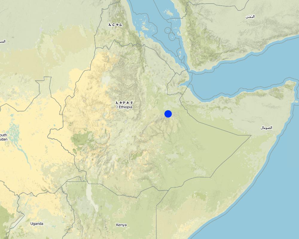
Country:
Ethiopia
Further specification of location:
Harea, Delo Belina, Bishan Bahe
Map
×2.6 Date of implementation
If precise year is not known, indicate approximate date:
- more than 50 years ago (traditional)
2.7 Introduction of the Technology
Specify how the Technology was introduced:
- as part of a traditional system (> 50 years)
Comments (type of project, etc.):
The technology evolved locally to address water shortages for crop production and reduce the top soil movement by runoff. At present improved techniques of constructing diversion ditches and efficient techniques for preparing Korbe have been included.
3. Classification of the SLM Technology
3.2 Current land use type(s) where the Technology is applied

Cropland
- Tree and shrub cropping
- Annual cropping
Comments:
Major land use problems (compiler’s opinion): Overgrazing on hillslopes causing severe degradation, human and livestock interferences in area enclosures, use of crop varities of low production.
Major land use problems (land users’ perception): Low fertility of soils and the associated decline in productionn and erratic rains
Other grazingland: open grazing
Other grazingland: stall-feeding
Type of cropping system and major crops comments: Sorghum - Sweet potato; Chat - Sorgum - Sweet potato
3.3 Further information about land use
Water supply for the land on which the Technology is applied:
- rainfed
Comments:
Water supply: post-flooding
Number of growing seasons per year:
- 1
Specify:
Longest growing period in days: 210
Longest growing period from month to month: Apr - Nov
3.5 Spread of the Technology
Specify the spread of the Technology:
- evenly spread over an area
If the Technology is evenly spread over an area, indicate approximate area covered:
- 10-100 km2
Comments:
Runoff or flood water diversion is a very common farming practice in Dire Dawa and the surrounding areas. Runoff and flood water from ephemeral rivers, road discharges and runoff from hillsides is diverted for supplimented irrigation in to cultivated fields. Cultivated fields are prepared in rectangular blocks, which are leveled and shaped such that maximum retention and cupturing of the water is possible. Korbe is very suitable for horticultural, fruit trees and high value crop production.
3.6 SLM measures comprising the Technology

structural measures
- S3: Graded ditches, channels, waterways

vegetative measures
- V1: Tree and shrub cover
Comments:
Main measures: vegetative measures, structural measures
Secondary measures: agronomic measures
Type of agronomic measures: early planting, mixed cropping / intercropping, mulching, legume inter-planting, contour ridging
Type of vegetative measures: aligned: -contour, aligned: -graded strips *<sup>3</sup>, in blocks
3.7 Main types of land degradation addressed by the Technology

soil erosion by water
- Wr: riverbank erosion

chemical soil deterioration
- Cn: fertility decline and reduced organic matter content (not caused by erosion)
Comments:
Main type of degradation addressed: Cn: fertility decline and reduced organic matter content
Secondary types of degradation addressed: Wr: riverbank erosion
3.8 Prevention, reduction, or restoration of land degradation
Specify the goal of the Technology with regard to land degradation:
- reduce land degradation
Comments:
Main goals: mitigation / reduction of land degradation
4. Technical specifications, implementation activities, inputs, and costs
4.2 Technical specifications/ explanations of technical drawing
Technical knowledge required for field staff / advisors: moderate
Technical knowledge required for land users: moderate
Main technical functions: reduction of slope angle, water harvesting / increase water supply
Secondary technical functions: control of dispersed runoff: retain / trap, increase of infiltration, water spreading, increase in soil fertility
Early planting
Material/ species: vegetables
Quantity/ density: 0.20x0.20
Remarks: nearly contour
Mixed cropping / intercropping
Material/ species: cabbage and pepper
Quantity/ density: 0.20x0.15
Remarks: on the ridge
Mulching
Material/ species: Residue
Contour ridging
Remarks: ridge + basin
Aligned: -contour
Vegetative material: F : fruit trees / shrubs, C : perennial crops
Vertical interval between rows / strips / blocks (m): 0.20-0.50 m
Spacing between rows / strips / blocks (m): 0.30-0.50m
Width within rows / strips / blocks (m): 1.80-3.80m
Aligned: -graded strips
Vegetative material: O : other
In blocks
Vegetative material: F : fruit trees / shrubs, O : other
Number of plants per (ha): 400-1000
Vertical interval between rows / strips / blocks (m): 0.30m
Spacing between rows / strips / blocks (m): 4x4
Vegetative measure: in blocks
Vegetative material: C : perennial crops
Number of plants per (ha): 1500-3000
Vertical interval between rows / strips / blocks (m): 0.1
Spacing between rows / strips / blocks (m): 2x4
Vegetative measure: Vegetative material: C : perennial crops
Vegetative measure: Vegetative material: C : perennial crops
Vegetative measure: Vegetative material: C : perennial crops
Fruit trees / shrubs species: Guava, papaya and mango
Perennial crops species: Chat and coffee
Slope (which determines the spacing indicated above): 3.00%
If the original slope has changed as a result of the Technology, the slope today is (see figure below): 1.00%
Gradient along the rows / strips: 0.00%
Reshaping surface
Vertical interval between structures (m): 0.3-0.5m
Spacing between structures (m): 3-4m
Depth of ditches/pits/dams (m): 0.2-0.3m
Width of ditches/pits/dams (m): 0.3
Height of bunds/banks/others (m): 0.25
Width of bunds/banks/others (m): 0.5
Structural measure: diversion ditch / cut-off drain
Depth of ditches/pits/dams (m): 0.3-0.5m
Width of ditches/pits/dams (m): 1-3m
Length of ditches/pits/dams (m): 500-2000m
Height of bunds/banks/others (m): 0.30m
Width of bunds/banks/others (m): 1-2m
Construction material (earth): blocks, ridges and furrow
Construction material (stone): the diversion ditch
Slope (which determines the spacing indicated above): 3%
If the original slope has changed as a result of the Technology, the slope today is: 1%
Lateral gradient along the structure: 0%
For water harvesting: the ratio between the area where the harvested water is applied and the total area from which water is collected is: 1:100
4.3 General information regarding the calculation of inputs and costs
other/ national currency (specify):
ETH Birr
Indicate exchange rate from USD to local currency (if relevant): 1 USD =:
8.50
Indicate average wage cost of hired labour per day:
0.85
4.4 Establishment activities
| Activity | Type of measure | Timing | |
|---|---|---|---|
| 1. | Land preparation/tillage/harrowing | Vegetative | dry season |
| 2. | Land preparation/tillage/harrowing | Vegetative | dry season |
| 3. | Land preparation/tillage/harrowing | Vegetative | |
| 4. | Land preparation/tillage/harrowing | Vegetative | dry season |
| 5. | Clearing | Structural | dry season |
| 6. | Clearing | Structural | |
| 7. | Clearing | Structural |
4.5 Costs and inputs needed for establishment
Comments:
Duration of establishment phase: 30 month(s)
4.6 Maintenance/ recurrent activities
| Activity | Type of measure | Timing/ frequency | |
|---|---|---|---|
| 1. | First tillage | Agronomic | dry season / each cropping season |
| 2. | First tillage | Agronomic | dry season / each cropping season |
| 3. | First tillage | Agronomic | dry season / each cropping season |
| 4. | First tillage | Agronomic | dry season / each cropping season |
| 5. | Repair of blocks | Vegetative | dry season /1-2 |
| 6. | Repair of blocks | Vegetative | dry season /1-2 |
| 7. | Repair of blocks | Vegetative | dry season /1-2 |
| 8. | Repair of blocks | Vegetative | dry season /1-2 |
| 9. | Repair breaks in diversion canal | Structural | |
| 10. | Repair breaks in diversion canal | Structural | |
| 11. | Repair breaks in diversion canal | Structural |
4.7 Costs and inputs needed for maintenance/ recurrent activities (per year)
Comments:
Machinery/ tools: Oxen plough, Dengora, Shovel
length of the diversion ditch and considering 0.5 ha of the land is planted by fruit trees and 0.5 ha planted with vegetables
4.8 Most important factors affecting the costs
Describe the most determinate factors affecting the costs:
labour required for the diversion ditch, block making and irrigation channels is high
5. Natural and human environment
5.1 Climate
Annual rainfall
- < 250 mm
- 251-500 mm
- 501-750 mm
- 751-1,000 mm
- 1,001-1,500 mm
- 1,501-2,000 mm
- 2,001-3,000 mm
- 3,001-4,000 mm
- > 4,000 mm
Agro-climatic zone
- semi-arid
Thermal climate class: tropics
5.2 Topography
Slopes on average:
- flat (0-2%)
- gentle (3-5%)
- moderate (6-10%)
- rolling (11-15%)
- hilly (16-30%)
- steep (31-60%)
- very steep (>60%)
Landforms:
- plateau/plains
- ridges
- mountain slopes
- hill slopes
- footslopes
- valley floors
Altitudinal zone:
- 0-100 m a.s.l.
- 101-500 m a.s.l.
- 501-1,000 m a.s.l.
- 1,001-1,500 m a.s.l.
- 1,501-2,000 m a.s.l.
- 2,001-2,500 m a.s.l.
- 2,501-3,000 m a.s.l.
- 3,001-4,000 m a.s.l.
- > 4,000 m a.s.l.
5.3 Soils
Soil depth on average:
- very shallow (0-20 cm)
- shallow (21-50 cm)
- moderately deep (51-80 cm)
- deep (81-120 cm)
- very deep (> 120 cm)
Soil texture (topsoil):
- coarse/ light (sandy)
Topsoil organic matter:
- medium (1-3%)
- low (<1%)
5.6 Characteristics of land users applying the Technology
Market orientation of production system:
- commercial/ market
- mixed (subsistence/ commercial
Off-farm income:
- less than 10% of all income
Relative level of wealth:
- average
Level of mechanization:
- manual work
Indicate other relevant characteristics of the land users:
Population density: 50-100 persons/km2
Annual population growth: 2% - 3%
40% of the land users are average wealthy.
40% of the land users are poor.
10% of the land users are poor.
Off-farm income specification: no big difference is observed between the average/better of and the poor in this regard.
5.7 Average area of land owned or leased by land users applying the Technology
- < 0.5 ha
- 0.5-1 ha
- 1-2 ha
- 2-5 ha
- 5-15 ha
- 15-50 ha
- 50-100 ha
- 100-500 ha
- 500-1,000 ha
- 1,000-10,000 ha
- > 10,000 ha
Is this considered small-, medium- or large-scale (referring to local context)?
- small-scale
5.8 Land ownership, land use rights, and water use rights
Land ownership:
- state
Land use rights:
- individual
6. Impacts and concluding statements
6.1 On-site impacts the Technology has shown
Socio-economic impacts
Production
crop production
fodder production
fodder quality
wood production
production area
Income and costs
farm income
Socio-cultural impacts
community institutions
SLM/ land degradation knowledge
Ecological impacts
Water cycle/ runoff
surface runoff
Quantity before SLM:
50
Quantity after SLM:
5
groundwater table/ aquifer
Soil
soil moisture
nutrient cycling/ recharge
6.2 Off-site impacts the Technology has shown
reliable and stable stream flows in dry season
downstream flooding
downstream siltation
6.3 Exposure and sensitivity of the Technology to gradual climate change and climate-related extremes/ disasters (as perceived by land users)
Gradual climate change
Gradual climate change
| Season | Type of climatic change/ extreme | How does the Technology cope with it? | |
|---|---|---|---|
| annual temperature | increase | well |
Climate-related extremes (disasters)
Meteorological disasters
| How does the Technology cope with it? | |
|---|---|
| local rainstorm | not well |
| local windstorm | well |
Climatological disasters
| How does the Technology cope with it? | |
|---|---|
| drought | well |
Hydrological disasters
| How does the Technology cope with it? | |
|---|---|
| general (river) flood | not well |
Other climate-related consequences
Other climate-related consequences
| How does the Technology cope with it? | |
|---|---|
| reduced growing period | well |
6.4 Cost-benefit analysis
How do the benefits compare with the establishment costs (from land users’ perspective)?
Short-term returns:
positive
Long-term returns:
very positive
How do the benefits compare with the maintenance/ recurrent costs (from land users' perspective)?
Short-term returns:
very positive
Long-term returns:
very positive
Comments:
Le bénéfice net est positif à cause de l’augmentation rapide de la production
6.5 Adoption of the Technology
Comments:
100% of land user families have adopted the Technology without any external material support
There is a moderate trend towards spontaneous adoption of the Technology
6.7 Strengths/ advantages/ opportunities of the Technology
| Strengths/ advantages/ opportunities in the land user’s view |
|---|
|
Increase the income of farmers (vegetables + fruits) How can they be sustained / enhanced? more diversified fruit and vegetable varieties to be introduced. |
|
Increase in productivity of land How can they be sustained / enhanced? access to credit services |
| Strengths/ advantages/ opportunities in the compiler’s or other key resource person’s view |
|---|
|
Enhancing of the rainfall multiplier effect How can they be sustained / enhanced? frequent maintenance of the diversion ditches and field canals, blocks. |
|
Good seed bed preparation enhancing germination and growth How can they be sustained / enhanced? levelling of land to be further continued and enhanced. |
|
Reduction of water losses by means of mulching How can they be sustained / enhanced? effective mulching to reduce evapotranspiration should be strengthened |
|
Facilitate formation of cooperatives and group work How can they be sustained / enhanced? more coopratives established and strengthen their management systems |
| Performing timely activities in the appropriate time |
6.8 Weaknesses/ disadvantages/ risks of the Technology and ways of overcoming them
| Weaknesses/ disadvantages/ risks in the land user’s view | How can they be overcome? |
|---|---|
| Lack of market | Organize marketing outlets |
| Earily perishable | Arrange proper storage system |
| Perte de terres (à cause des structures de conservation) | compensée par le bénéfice de la production augmentée |
| Inaccessibilité des marchés |
| Weaknesses/ disadvantages/ risks in the compiler’s or other key resource person’s view | How can they be overcome? |
|---|---|
| Increased labour constraints: construction of diversion ditches, preparation of irrigation basin and spreading the runoff water and regular maintenance / reconstruction of structures is very labour intensive |
providing improved farm tools could improve efficiency of operation, organising farmers in groups for sharing labor would curtail labor problems; Placing permanent structures at the iversion head (concrete) and paving ditches to improve channel stability would reduce maintenance activities. |
| Social inequity: mainly better-off farmers apply the technology (due to high costs) |
providing credit solves financial problems and facilitating market would motivate land users to get more engaged in the business. |
| Loss of land (through conservation structures | is outweighed by the high production benefits. |
7. References and links
7.2 References to available publications
Title, author, year, ISBN:
Danano D. 2008 (unpublished): Soil and Water Conservation Practices for Sustainable Land Management in Ethiopia. Ethiocat.
Links and modules
Expand all Collapse allLinks
No links
Modules
No modules