Dejen Stone Bund [Ethiopia]
- Creation:
- Update:
- Compiler: Unknown User
- Editor: –
- Reviewers: Fabian Ottiger, Alexandra Gavilano
Gidad, Irken
technologies_1059 - Ethiopia
View sections
Expand all Collapse all1. General information
1.3 Conditions regarding the use of data documented through WOCAT
The compiler and key resource person(s) accept the conditions regarding the use of data documented through WOCAT:
Yes
2. Description of the SLM Technology
2.1 Short description of the Technology
Definition of the Technology:
Stone bund is an enbankment of stone constructed acrros the slope following the contour.
2.2 Detailed description of the Technology
Description:
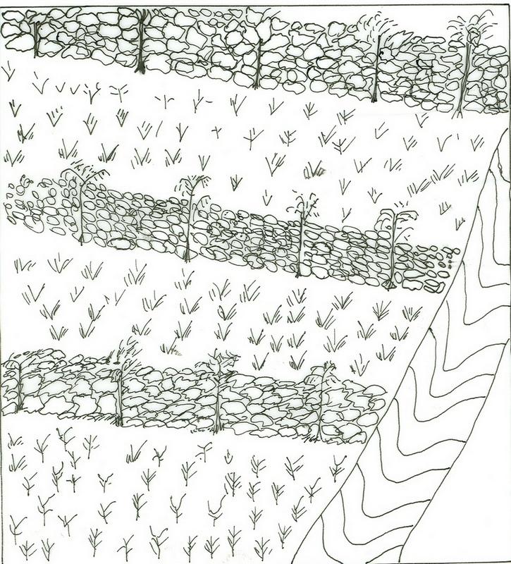
It is a stone wall stablized with grasses and fodder plant species. Its main purpose is moisture harvesting and soil erosion control. Establishment is made first by laying out contour lines, digging foundation and placing of stones in a manner to interlock to each other. Stone bunds placed on contour are known as level stone bunds. The purpose is to arrest runoff and enhance soil moisture to increaseavailability of water to plants. It is also aimed at controlling soil erosion from cultivated fields such that the plants have sufficient soil depth to establish and grow. Maintenance is done every year especially before thev rains. Maintenance continues for several years until the slope of the terraced land forms nearly level bench or slightly sloping outward terrace. The technology is suitable to semi-arid and arid climatic conditions having steep to very steep cultivated lands. It is suitable to major annual cereal crops, perennial crops, fruit trees and cash crops.
2.3 Photos of the Technology
Media Gallery
2.5 Country/ region/ locations where the Technology has been applied and which are covered by this assessment
Country:
Ethiopia
Region/ State/ Province:
Amhara/Dejen
Further specification of location:
Dejen-Inemay
Comments:
Total area covered by the SLM Technology is 10 km2.
The technology is applied mostly on the low land part of the woreda.
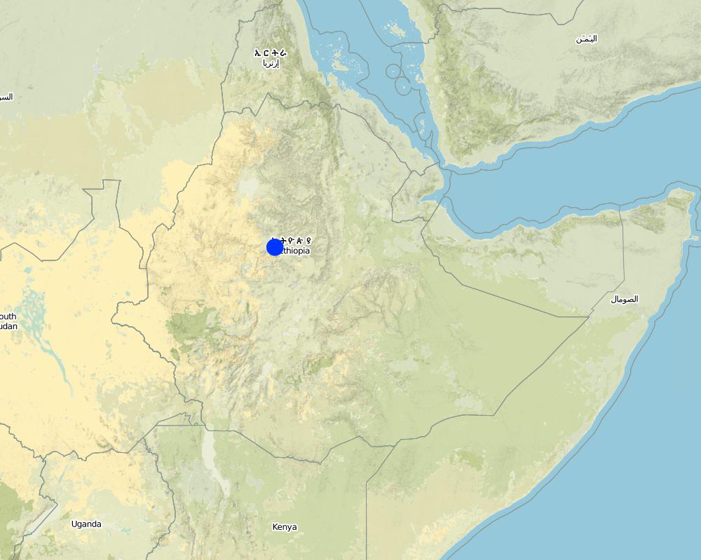
Map
×2.6 Date of implementation
If precise year is not known, indicate approximate date:
- less than 10 years ago (recently)
2.7 Introduction of the Technology
Specify how the Technology was introduced:
- through projects/ external interventions
Comments (type of project, etc.):
Originally it is indiginous and now some improvement techniques have been included.
3. Classification of the SLM Technology
3.1 Main purpose(s) of the Technology
- improve production
- reduce, prevent, restore land degradation
3.2 Current land use type(s) where the Technology is applied

Cropland
- Annual cropping
- Tree and shrub cropping
Annual cropping - Specify crops:
- cereals - other
- cereals - sorghum
- oilseed crops - sunflower, rapeseed, other
- teff,
Tree and shrub cropping - Specify crops:
- fruits, other
- sugar cane, Sesbania, leucaena
Number of growing seasons per year:
- 1
Specify:
Longest growing period in days: 210
Is crop rotation practiced?
Yes
If yes, specify:
sorghum-teff-sorghum
Comments:
Major land use problems (compiler’s opinion): Overgrazing with little vegetation cover and exposed surface, cultivating on very steep slopes.
Major land use problems (land users’ perception): Low productivity of land, erosion, low soil fertility and surface stoniness.
Type of cropping system and major crops comments: sorghum-teff-sorghum
3.4 Water supply
Water supply for the land on which the Technology is applied:
- rainfed
Comments:
Water supply: Also mixed rainfed - irrigated
3.5 SLM group to which the Technology belongs
- cross-slope measure
3.6 SLM measures comprising the Technology
3.7 Main types of land degradation addressed by the Technology

soil erosion by water
- Wt: loss of topsoil/ surface erosion
- Wg: gully erosion/ gullying

chemical soil deterioration
- Cn: fertility decline and reduced organic matter content (not caused by erosion)
Comments:
Main type of degradation addressed: Wt: loss of topsoil / surface erosion
Secondary types of degradation addressed: Wg: gully erosion / gullying, Cn: fertility decline and reduced organic matter content
3.8 Prevention, reduction, or restoration of land degradation
Specify the goal of the Technology with regard to land degradation:
- reduce land degradation
Comments:
Secondary goals: prevention of land degradation, rehabilitation / reclamation of denuded land
4. Technical specifications, implementation activities, inputs, and costs
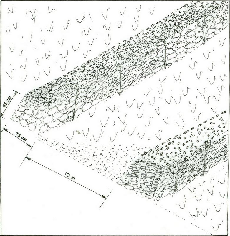
4.1 Technical drawing of the Technology
Technical specifications (related to technical drawing):
Amhara
Technical knowledge required for field staff / advisors: moderate
Technical knowledge required for land users: moderate
Main technical functions: control of dispersed runoff: retain / trap
Secondary technical functions: reduction of slope angle, reduction of slope length, increase of infiltration, water harvesting / increase water supply
Better crop cover
Material/ species: Sorghum, Teff, Suflower
Remarks: broad cast
Contour planting / strip cropping
Material/ species: Sesbania, leucaena
Remarks: by planting across the slope
Agronomic measure: removing less vegetation cover
Material/ species: Crop residue, grasses
Remarks: across the slope
Mineral (inorganic) fertilizers
Material/ species: DAP/Urea
Quantity/ density: 150 Kg/ha
Remarks: Sown by broadcasting
Contour tillage
Remarks: oxen plough
Pits
Remarks: hand pick axe
Aligned: -contour
Vegetative material: T : trees / shrubs
Number of plants per (ha): 1500
Vertical interval between rows / strips / blocks (m): 1m
Spacing between rows / strips / blocks (m): 5 m
Vertical interval within rows / strips / blocks (m): 1m
Width within rows / strips / blocks (m): 2m
Scattered / dispersed
Vegetative material: T : trees / shrubs
Number of plants per (ha): 500
Spacing between rows / strips / blocks (m): 5m
Width within rows / strips / blocks (m): 10m
Trees/ shrubs species: sesbania
Grass species: local
Slope (which determines the spacing indicated above): 15.00%
If the original slope has changed as a result of the Technology, the slope today is (see figure below): 10.00%
Gradient along the rows / strips: 0.00%
Bund/ bank: level
Vertical interval between structures (m): 2m
Spacing between structures (m): 10m
Height of bunds/banks/others (m): 0.45m
Width of bunds/banks/others (m): 0.45m
Length of bunds/banks/others (m): 80m
Structural measure: diversion ditch / cut-off drain
Depth of ditches/pits/dams (m): 0.4m
Width of ditches/pits/dams (m): 0.3m
Length of ditches/pits/dams (m): 58m
Height of bunds/banks/others (m): 0.75m
Width of bunds/banks/others (m): 1.0m
Length of bunds/banks/others (m): 58m
Construction material (earth): reinforce the stone embankment
Construction material (stone): strengthen/support the terrace wall
Slope (which determines the spacing indicated above): 15%
If the original slope has changed as a result of the Technology, the slope today is: 10%
Lateral gradient along the structure: 0%
Vegetation is used for stabilisation of structures.
Other type of management: change of management / intensity level - from random/open access to controlled system
4.2 General information regarding the calculation of inputs and costs
other/ national currency (specify):
Birr
If relevant, indicate exchange rate from USD to local currency (e.g. 1 USD = 79.9 Brazilian Real): 1 USD =:
8.6
Indicate average wage cost of hired labour per day:
0.70
4.3 Establishment activities
| Activity | Timing (season) | |
|---|---|---|
| 1. | preparation of seedlings | dry season |
| 2. | transporting of seedlings | rainy season |
| 3. | plantation on bund | rainy season |
| 4. | surveying | dry season |
| 5. | collecting of stones | dry season |
| 6. | constructing the bund | dry season |
| 7. | Seek solution for the management problems | before harvesting |
| 8. | controlling the development activities by guarding from free grazing animals. | after harvesting |
| 9. | discussing on management and measures | before harvesting |
4.4 Costs and inputs needed for establishment
| Specify input | Unit | Quantity | Costs per Unit | Total costs per input | % of costs borne by land users | |
|---|---|---|---|---|---|---|
| Labour | Labour | ha | 1.0 | 236.0 | 236.0 | 100.0 |
| Equipment | Tools | ha | 1.0 | 6.0 | 6.0 | 100.0 |
| Plant material | Seedlings | ha | 1.0 | 58.0 | 58.0 | 100.0 |
| Construction material | Stone | ha | 1.0 | 83.0 | 83.0 | 100.0 |
| Total costs for establishment of the Technology | 383.0 | |||||
| Total costs for establishment of the Technology in USD | 44.53 | |||||
Comments:
Duration of establishment phase: 24 month(s)
4.5 Maintenance/ recurrent activities
| Activity | Timing/ frequency | |
|---|---|---|
| 1. | Contour ploughing | dry season / three times |
| 2. | Harrowing | dry season / one time |
| 3. | Planting | wet season / one time |
| 4. | Temporary trashline | dry -rainy season / |
| 5. | Residues | dry season / many times |
| 6. | Weeding | rainy season / two times |
| 7. | Harvest | dry season / annual |
| 8. | cutting/prunnig | dry season /after and befor cropping |
| 9. | repair breaks | dry season/annually |
4.6 Costs and inputs needed for maintenance/ recurrent activities (per year)
| Specify input | Unit | Quantity | Costs per Unit | Total costs per input | % of costs borne by land users | |
|---|---|---|---|---|---|---|
| Labour | Labour | ha | 1.0 | 30.0 | 30.0 | 100.0 |
| Plant material | Seedlings | ha | 1.0 | 30.0 | 30.0 | 100.0 |
| Construction material | Stone | ha | 1.0 | 12.0 | 12.0 | 100.0 |
| Total costs for maintenance of the Technology | 72.0 | |||||
| Total costs for maintenance of the Technology in USD | 8.37 | |||||
Comments:
Machinery/ tools: hoe, sickle, axe, pad, spane
length of structure per ha of land protected
4.7 Most important factors affecting the costs
Describe the most determinate factors affecting the costs:
slope, soil depth
5. Natural and human environment
5.1 Climate
Annual rainfall
- < 250 mm
- 251-500 mm
- 501-750 mm
- 751-1,000 mm
- 1,001-1,500 mm
- 1,501-2,000 mm
- 2,001-3,000 mm
- 3,001-4,000 mm
- > 4,000 mm
Agro-climatic zone
- sub-humid
5.2 Topography
Slopes on average:
- flat (0-2%)
- gentle (3-5%)
- moderate (6-10%)
- rolling (11-15%)
- hilly (16-30%)
- steep (31-60%)
- very steep (>60%)
Landforms:
- plateau/plains
- ridges
- mountain slopes
- hill slopes
- footslopes
- valley floors
Altitudinal zone:
- 0-100 m a.s.l.
- 101-500 m a.s.l.
- 501-1,000 m a.s.l.
- 1,001-1,500 m a.s.l.
- 1,501-2,000 m a.s.l.
- 2,001-2,500 m a.s.l.
- 2,501-3,000 m a.s.l.
- 3,001-4,000 m a.s.l.
- > 4,000 m a.s.l.
Comments and further specifications on topography:
Slopes on average: Hilly (mostly terraced by stone bunds). Also rolling (ranked 2) and steep (ranked 3)
5.3 Soils
Soil depth on average:
- very shallow (0-20 cm)
- shallow (21-50 cm)
- moderately deep (51-80 cm)
- deep (81-120 cm)
- very deep (> 120 cm)
Soil texture (topsoil):
- coarse/ light (sandy)
Topsoil organic matter:
- low (<1%)
If available, attach full soil description or specify the available information, e.g. soil type, soil PH/ acidity, Cation Exchange Capacity, nitrogen, salinity etc.
Soil fertility is low-very low
Soil drainage/ infiltration is good-medium
Soil water storage capacity is low-very low
5.6 Characteristics of land users applying the Technology
Market orientation of production system:
- subsistence (self-supply)
Off-farm income:
- less than 10% of all income
Relative level of wealth:
- very poor
- poor
Level of mechanization:
- manual work
- animal traction
Indicate other relevant characteristics of the land users:
Population density: 50-100 persons/km2
Annual population growth: 2% - 3%
and own 50% of the land.
and own 40% of the land.
and own 10% of the land.
Off-farm income specification: In the land with proper conservation techniques the productivity increased by about two folds whereas the land with out conservation measures yield is seen to decrease
5.7 Average area of land used by land users applying the Technology
- < 0.5 ha
- 0.5-1 ha
- 1-2 ha
- 2-5 ha
- 5-15 ha
- 15-50 ha
- 50-100 ha
- 100-500 ha
- 500-1,000 ha
- 1,000-10,000 ha
- > 10,000 ha
Comments:
Grazing land: Far away from homesteads.
5.8 Land ownership, land use rights, and water use rights
Land ownership:
- state
6. Impacts and concluding statements
6.1 On-site impacts the Technology has shown
Socio-economic impacts
Production
crop production
fodder production
Comments/ specify:
Due to bund plantation
fodder quality
Comments/ specify:
Due to bund plantation
production area
Comments/ specify:
The loss is only for the first two years
Income and costs
farm income
Socio-cultural impacts
community institutions
conflict mitigation
Comments/ specify:
Because of placements of cutoff drains
Ecological impacts
Water cycle/ runoff
excess water drainage
Soil
soil cover
6.2 Off-site impacts the Technology has shown
downstream flooding
Comments/ specify:
Sediment trapped on the bunds
6.4 Cost-benefit analysis
How do the benefits compare with the establishment costs (from land users’ perspective)?
Short-term returns:
negative
Long-term returns:
slightly positive
How do the benefits compare with the maintenance/ recurrent costs (from land users' perspective)?
Short-term returns:
slightly negative
Long-term returns:
slightly positive
6.5 Adoption of the Technology
Of all those who have adopted the Technology, how many did so spontaneously, i.e. without receiving any material incentives/ payments?
- 91-100%
Comments:
320 land user families have adopted the Technology without any external material support
Comments on spontaneous adoption: estimates
There is a moderate trend towards spontaneous adoption of the Technology
Comments on adoption trend: Farmers in the near by village are gradually adopting good lessons learnet from farmers who have implemented the technology. As a result the technology is expanding in the area.
6.7 Strengths/ advantages/ opportunities of the Technology
| Strengths/ advantages/ opportunities in the land user’s view |
|---|
|
The soil stablizes because of bund plantation How can they be sustained / enhanced? maintenance and proper management needed. |
| Strengths/ advantages/ opportunities in the compiler’s or other key resource person’s view |
|---|
|
reduction of slope How can they be sustained / enhanced? frequent maintenance and avoid free grazing |
|
increase soil depth How can they be sustained / enhanced? frequent maintenance and avoid free grazing |
6.8 Weaknesses/ disadvantages/ risks of the Technology and ways of overcoming them
| Weaknesses/ disadvantages/ risks in the land user’s view | How can they be overcome? |
|---|---|
| Loss of land for few years | Make bund area productive |
| Weaknesses/ disadvantages/ risks in the compiler’s or other key resource person’s view | How can they be overcome? |
|---|---|
| Conflicts | discussion and reaching agreements |
7. References and links
7.1 Methods/ sources of information
7.2 References to available publications
Title, author, year, ISBN:
monthly, quarterly and annual acheivment report of the woreda
Title, author, year, ISBN:
work norm
Title, author, year, ISBN:
Soil map: assistance for land use planning and regulatory department.
Links and modules
Expand all Collapse allLinks
No links
Modules
No modules