Spate Irrigation [Eritrea]
- Creation:
- Update:
- Compiler: Unknown User
- Editor: –
- Reviewers: Fabian Ottiger, Deborah Niggli, Alexandra Gavilano
technologies_1333 - Eritrea
View sections
Expand all Collapse all1. General information
1.2 Contact details of resource persons and institutions involved in the assessment and documentation of the Technology
Key resource person(s)
SLM specialist:
Abraham Mehari Haile
UNESCO-IHE Institute for Water Education, Delft, The Netherlands
Netherlands
1.3 Conditions regarding the use of data documented through WOCAT
The compiler and key resource person(s) accept the conditions regarding the use of data documented through WOCAT:
Yes
2. Description of the SLM Technology
2.1 Short description of the Technology
Definition of the Technology:
Spate irrigation is a traditional water diversion and spreading technology.
2.2 Detailed description of the Technology
Description:
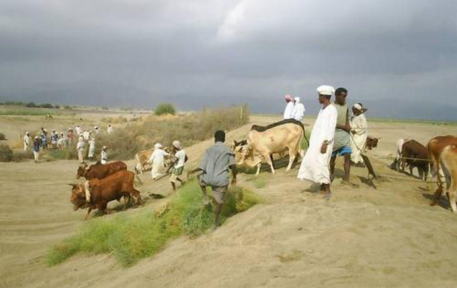
Spate irrigation has a long history in Eritrea and still forms the livelihood base for rural communities in arid lowlands of the country.
Purpose of the Technology: It is a traditional water diversion and spreading technique under which seasonal floods of short duration – springing from the rainfall-rich highlands – are diverted from ephemeral rivers (wadis) to irrigate cascades of leveled and bunded fields in the coastal plains.
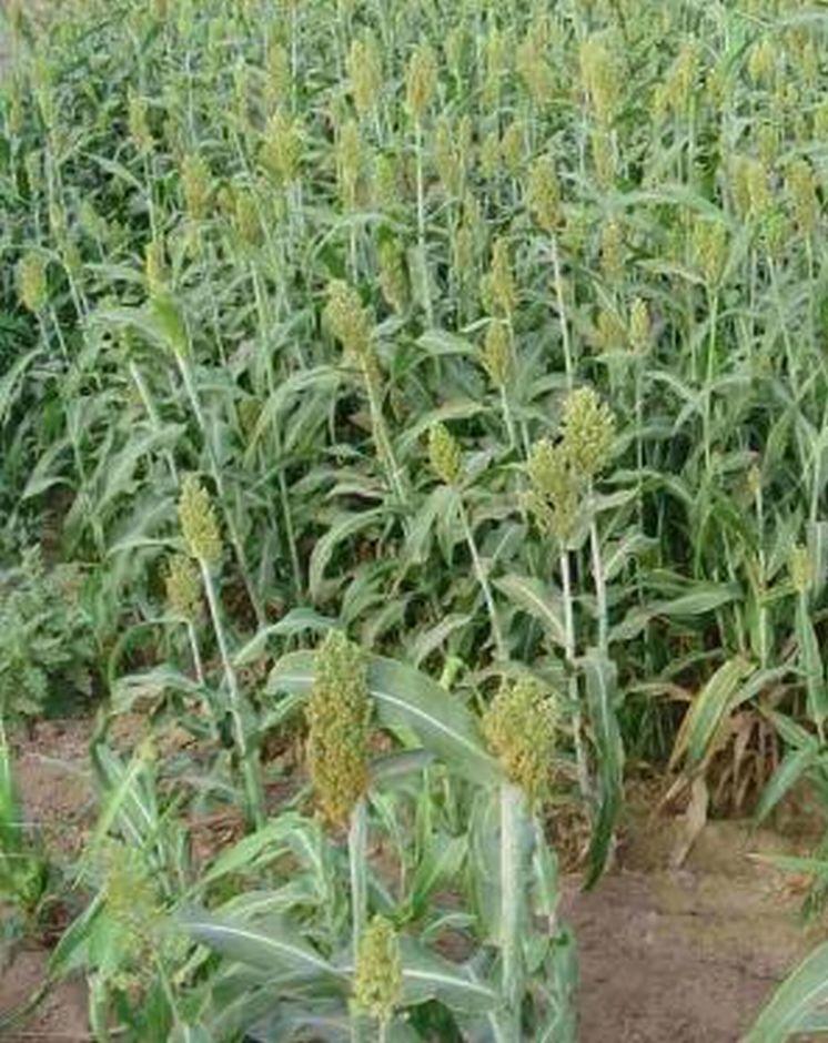
Establishment / maintenance activities and inputs: The diversion structures include the following elements: (1) the ‘agim’, a temporary 3-4 m high river diversion structure on the low-flow side of the wadi, made from brushwood, tree trunks, earth, stones and/or boulders, erected to divert a large part of the flow during a spate flow to adjacent agricultural fields; (2) a primary, and several secondary, distribution canals; unlined, bordered by earthen embankments; convey and spread the floodwater to the irrigable fields; (3) the fields, rectangular shaped, of about 1–2 ha, separated by earthen bunds. Floodwater is distributed from field to field: when a field is completely flooded (to a depth of about 0.5 m), water is conveyed to the immediate downstream field by breaching one of the bunds. This process continues until all the water is used up. Arable fields need to be flooded several times. The water soaks deep into the soil profile (up to 2.4 m) and provides moisture sufficient for two or even three harvests: crop growth is entirely dependent on the residual soil moisture. The main crop grown is sorghum; maize is the next most important. Sedimentation is as important as water management: With each flood, soil is built up by depositing rich sediment on the fields. Due to the force of the floods, the diversion structures are frequently damaged and/or washed away. Reconstruction and maintenance are labour-intensive and require collective community action.
Natural / human environment: Elaborate local regulations, organization and cooperation at the community level are prerequisites for successful management of spate irrigation systems.
2.3 Photos of the Technology
Media Gallery
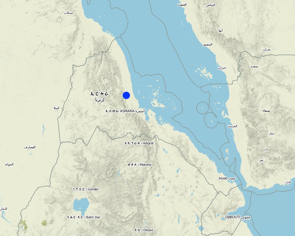
2.5 Country/ region/ locations where the Technology has been applied and which are covered by this assessment
Country:
Eritrea
Region/ State/ Province:
Sheeb area, Eastern lowlands
Further specification of location:
Wadi Laba
Specify the spread of the Technology:
- evenly spread over an area
If the Technology is evenly spread over an area, specify area covered (in km2):
160.0
Comments:
Total area covered by the SLM Technology is 160 km2.
Current spate irrigation area in Eritrea is 16’000 hectares. Potential area is estimated at 60’000–90’000 hectares.
Map
×2.6 Date of implementation
If precise year is not known, indicate approximate date:
- more than 50 years ago (traditional)
2.7 Introduction of the Technology
Specify how the Technology was introduced:
- as part of a traditional system (> 50 years)
Comments (type of project, etc.):
Spate irrigation is an indigenous technology, originally introduced from Yemen
3. Classification of the SLM Technology
3.1 Main purpose(s) of the Technology
- improve production
- reduce, prevent, restore land degradation
3.2 Current land use type(s) where the Technology is applied

Cropland
- Annual cropping
Annual cropping - Specify crops:
- cereals - maize
- cereals - sorghum
Comments:
Livestock is grazing on crop residues
3.4 Water supply
Comments:
Water supply: post-flooding
3.5 SLM group to which the Technology belongs
- irrigation management (incl. water supply, drainage)
- surface water management (spring, river, lakes, sea)
3.6 SLM measures comprising the Technology

structural measures
- S3: Graded ditches, channels, waterways
Comments:
Main measures: structural measures
4. Technical specifications, implementation activities, inputs, and costs
4.1 Technical drawing of the Technology
Technical specifications (related to technical drawing):
Cross section of an agim (top left); Components of a traditional spate irrigation system: (1) agim; (2) main distribution canal; (3) irrigated fields; (4) earthen embankments. Arrows indicate the water flow
Technical knowledge required for field staff / advisors: high
Technical knowledge required for land users: high
Main technical functions: control of concentrated runoff: drain / divert, increase of infiltration, water harvesting / increase water supply, water spreading
Diversion ditch/ drainage
Depth of ditches/pits/dams (m): 4.00
Construction material (earth): earth
Construction material (stone): stones
Construction material (wood): brushwood, tree trunks
Author:
Mats Gurtner, Center for Development and Environment, University of Bern
4.3 Establishment activities
| Activity | Timing (season) | |
|---|---|---|
| 1. | Construction of diversion structure (agim) | before rainy season |
| 2. | Construction of main distribution canal | before rainy season |
| 3. | Construction of secondary distribution canals | before rainy season |
| 4. | Leveling of fields | before rainy season |
| 5. | Establish embankments around fields and within fields | before rainy season |
4.4 Costs and inputs needed for establishment
| Specify input | Unit | Quantity | Costs per Unit | Total costs per input | % of costs borne by land users | |
|---|---|---|---|---|---|---|
| Labour | Labour | ha | 1.0 | 24.0 | 24.0 | |
| Equipment | Animal traction | ha | 1.0 | 36.0 | 36.0 | |
| Total costs for establishment of the Technology | 60.0 | |||||
| Total costs for establishment of the Technology in USD | 60.0 | |||||
4.5 Maintenance/ recurrent activities
| Activity | Timing/ frequency | |
|---|---|---|
| 1. | Reconstruction / repair of diversion structures (2-4 times / year; collective community action) | 2-4 times / year |
| 2. | Desilting / repair of distribution canals | annual |
| 3. | Raising of bund heights due to silting up of fields | annual |
| 4. | Flood fields (community action, during highland rainy season: July-September). Most likely a field receives 3 irrigation turns, on a bi-weekly interval between any 2 turns | rainy season (july-september) |
| 5. | Soil tillage (15 cm deep; using oxen-drawn plough) to break capillary uplift of soil water and to create evaporation barrier | end of flooding season |
4.6 Costs and inputs needed for maintenance/ recurrent activities (per year)
| Specify input | Unit | Quantity | Costs per Unit | Total costs per input | % of costs borne by land users | |
|---|---|---|---|---|---|---|
| Labour | Labour | ha | 1.0 | 24.0 | 24.0 | |
| Equipment | Animal traction | ha | 1.0 | 36.0 | 36.0 | |
| Total costs for maintenance of the Technology | 60.0 | |||||
| Total costs for maintenance of the Technology in USD | 60.0 | |||||
Comments:
Machinery/ tools: scouring and tillage implements, shovels
The costs were calculated per unit = 10 m long agim (1 m high, 3 m wide), constructed with mixed material (stones, earth, brushwood)
4.7 Most important factors affecting the costs
Describe the most determinate factors affecting the costs:
Data on labour inputs for construction/maintenance of canals and field bunds are not included, therefore not included in the tables above. Costs for agim reconstruction are 40% of establishment. Total maintenance costs depend on the number of reconstructions during normal spate season (2-4 times). The yearly cost (establishment and maintenance) reaches US$ 60-156.
5. Natural and human environment
5.1 Climate
Annual rainfall
- < 250 mm
- 251-500 mm
- 501-750 mm
- 751-1,000 mm
- 1,001-1,500 mm
- 1,501-2,000 mm
- 2,001-3,000 mm
- 3,001-4,000 mm
- > 4,000 mm
Agro-climatic zone
- arid
Thermal climate class: tropics
5.2 Topography
Slopes on average:
- flat (0-2%)
- gentle (3-5%)
- moderate (6-10%)
- rolling (11-15%)
- hilly (16-30%)
- steep (31-60%)
- very steep (>60%)
Landforms:
- plateau/plains
- ridges
- mountain slopes
- hill slopes
- footslopes
- valley floors
Altitudinal zone:
- 0-100 m a.s.l.
- 101-500 m a.s.l.
- 501-1,000 m a.s.l.
- 1,001-1,500 m a.s.l.
- 1,501-2,000 m a.s.l.
- 2,001-2,500 m a.s.l.
- 2,501-3,000 m a.s.l.
- 3,001-4,000 m a.s.l.
- > 4,000 m a.s.l.
Comments and further specifications on topography:
Altitudinal zone: 101-500 m a.s.l. (200 m.a.s.l.)
5.3 Soils
Soil depth on average:
- very shallow (0-20 cm)
- shallow (21-50 cm)
- moderately deep (51-80 cm)
- deep (81-120 cm)
- very deep (> 120 cm)
Soil texture (topsoil):
- medium (loamy, silty)
If available, attach full soil description or specify the available information, e.g. soil type, soil PH/ acidity, Cation Exchange Capacity, nitrogen, salinity etc.
Soil texture is medium (loam to silt loams)
Soil fertility is very high (alluvial silts formed by annual sedimentation)
Soil drainage/infiltration is good
5.4 Water availability and quality
Availability of surface water:
excess
5.6 Characteristics of land users applying the Technology
Market orientation of production system:
- subsistence (self-supply)
Relative level of wealth:
- very poor
- poor
Individuals or groups:
- groups/ community
Level of mechanization:
- manual work
- animal traction
Indicate other relevant characteristics of the land users:
Land users applying the Technology are mainly disadvantaged land users
Difference in the involvement of women and men: water management carried out communally, crop management individually
5.7 Average area of land used by land users applying the Technology
- < 0.5 ha
- 0.5-1 ha
- 1-2 ha
- 2-5 ha
- 5-15 ha
- 15-50 ha
- 50-100 ha
- 100-500 ha
- 500-1,000 ha
- 1,000-10,000 ha
- > 10,000 ha
Is this considered small-, medium- or large-scale (referring to local context)?
- small-scale
5.8 Land ownership, land use rights, and water use rights
Land ownership:
- state
Land use rights:
- individual
6. Impacts and concluding statements
6.1 On-site impacts the Technology has shown
Socio-economic impacts
Production
crop production
fodder production
Comments/ specify:
Residues are fed to livestock
production area
Comments/ specify:
Without irrigation, agricultural production is not possible
Income and costs
farm income
Socio-cultural impacts
food security/ self-sufficiency
community institutions
Ecological impacts
Water cycle/ runoff
harvesting/ collection of water
Soil
soil moisture
nutrient cycling/ recharge
6.3 Exposure and sensitivity of the Technology to gradual climate change and climate-related extremes/ disasters (as perceived by land users)
Gradual climate change
Gradual climate change
| Season | increase or decrease | How does the Technology cope with it? | |
|---|---|---|---|
| annual temperature | increase | well |
Climate-related extremes (disasters)
Meteorological disasters
| How does the Technology cope with it? | |
|---|---|
| local rainstorm | well |
| local windstorm | well |
Climatological disasters
| How does the Technology cope with it? | |
|---|---|
| drought | well |
Hydrological disasters
| How does the Technology cope with it? | |
|---|---|
| general (river) flood | well |
Comments:
The technology is tolerant to climatic extremes (adapted to unpredictable heavy floods)
6.4 Cost-benefit analysis
Comments:
no data
6.5 Adoption of the Technology
Comments:
There is a strong trend towards spontaneous adoption of the Technology
Comments on adoption trend: Spontaneous spread takes place throughout the lowlands. Current spate irrigation area in Eritrea is 16’000 hectares. Potential area is estimated at 60’000–90’000 hectares.
6.7 Strengths/ advantages/ opportunities of the Technology
| Strengths/ advantages/ opportunities in the compiler’s or other key resource person’s view |
|---|
| Spate irrigation forms the livelihood base for rural communities in arid lowlands of the country |
6.8 Weaknesses/ disadvantages/ risks of the Technology and ways of overcoming them
| Weaknesses/ disadvantages/ risks in the land user’s view | How can they be overcome? |
|---|---|
| Highly labour-intensive and time consuming maintenance; water diversion structures are frequently breached / washed away by heavy floods; canals are obstructed through deposition of boulders, gravel and coarse sediments. | To overcome all 3 problems, recommendations focus on building permanent flood diversion and distribution structures which: |
| Great demand for wood: huge numbers of trees are annually needed for (re-)constructing diversion structures | (1) withstand the force of heavy floods and divert the water effectively; |
| Irrigation efficiency is only about 20% because of the difficulty of controlling large amounts of water in a short period of time (and often at night) and because water is lost by percolation, seepage and evaporation | (2) eliminate the need to cut trees |
| (3) reduce human and animal labour inputs | |
| (4) increase productivity; Lining the main canals with cements would reduce water loss by percolation and seepage. Proper leveling of basin fields helps to distribute the floodwater uniformly |
7. References and links
7.2 References to available publications
Title, author, year, ISBN:
Abraham Mehari H, Van Steenbergen F, Verheijen O, Van Aarst S:Spate Irrigation, Livelihood Improvement and Adaptation to Climate Variability and Change
Title, author, year, ISBN:
Mehretab Tesfai Stroosnijder L:The Eritrean spate irrigation system
Title, author, year, ISBN:
Berhane Haile G, Van Steenbergen F: Agricultural Water Management in Ephemeral Rivers: Community Management in Spate Irrigation in Eritrea; in African Water Journal
7.3 Links to relevant online information
Title/ description:
Abraham Mehari, Depeweg, H, Schultz B (2005): Hydraulic Performance Evaluation of The Wadi Laba Spate Irrigation Systemin Eritrea, in Irrigation and Drainage. 54: 389–406
URL:
www.interscience.wiley.com
Title/ description:
Berhane Haile G: Community Spate Irrigation in Bada, Eritrea n Mehretab Tesfai, Stroosnijder L (2000): The Eritrean spate irrigation system
URL:
linkinghub.elsevier.com/retrieve/pii/S0378377400001153
Links and modules
Expand all Collapse allLinks
No links
Modules
No modules