Contour Trench cum Bund [India]
- Creation:
- Update:
- Compiler: Niranjan Sahu
- Editor: –
- Reviewers: Fabian Ottiger, Alexandra Gavilano
Samapatana nali o huda ( Oriya)
technologies_1480 - India
View sections
Expand all Collapse all1. General information
1.2 Contact details of resource persons and institutions involved in the assessment and documentation of the Technology
Key resource person(s)
SLM specialist:
SLM specialist:
SLM specialist:
Patel Anita
1.3 Conditions regarding the use of data documented through WOCAT
The compiler and key resource person(s) accept the conditions regarding the use of data documented through WOCAT:
Yes
1.5 Reference to Questionnaire(s) on SLM Approaches (documented using WOCAT)

Participatory Sustainable Rural Livelihood Approach [India]
Participatory Sustainable Rural Livelihood Approach adopts participatory tools for livelihood situational analysis of the five capitals(Physical, Financila,Social, Human and Natural) and prepare livelihood focussed micro plan with the commuity for sustai
- Compiler: Niranjan Sahu
2. Description of the SLM Technology
2.1 Short description of the Technology
Definition of the Technology:
Contour trench cum bund is a bund laid out on contour along with trench either staggered or continuous to check the velocity of run off, conserve in situ moisture, increse ground water recharge and there by establish a sustainable land use system.
2.2 Detailed description of the Technology
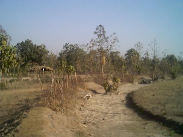
Description:
It is a structural measure. The bund is constructed taking the excavated earth from a trench of 1.5m X 0.3m cross section and leaving a berm of 0.3m and put along the contour. Loose boulder water way are constructed on the bund for safe disposal of excess run off.
Purpose: To break the slope of land. To reduce the velocity of runoff. To increase the in situ soil moisture and increase ground water table. To reduce down stream sand casting.
Establishment / maintenance activities and inputs: The process adopted for implementation of the intervention followed participatory planning through resource mapping, transect, well being ranking, problem identification, prioritisation and negotiation; thus benefit sharing, contribution and future maintenance of the stucture is ensured before establishment of the structure. The poor land and poor people get the opportunity first.
2.3 Photos of the Technology
Media Gallery
2.5 Country/ region/ locations where the Technology has been applied and which are covered by this assessment
Country:
India
Region/ State/ Province:
Orissa
Further specification of location:
Nangalbod-Tankamal Watershed,Mahanadi Basin
Specify the spread of the Technology:
- evenly spread over an area
If the Technology is evenly spread over an area, specify area covered (in km2):
0.32
If precise area is not known, indicate approximate area covered:
- 0.1-1 km2
Comments:
Total area covered by the SLM Technology is 0.32 km2.
The technology area comprises of 0.3 2km2 within the watershed of 6 km2. The technology is an improvement of the age old practice of field bunding by the farmers.This has been promoted by the Soil Conservation department and watershed mission through watershed development programme.
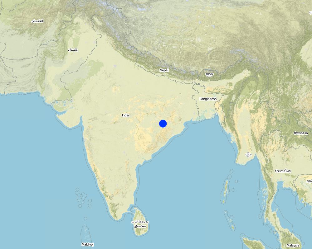
Map
×2.6 Date of implementation
If precise year is not known, indicate approximate date:
- more than 50 years ago (traditional)
2.7 Introduction of the Technology
Specify how the Technology was introduced:
- through projects/ external interventions
Comments (type of project, etc.):
Indegeneous but improved by Soil Conservation department, Watershed Mission, UNDP.
3. Classification of the SLM Technology
3.1 Main purpose(s) of the Technology
- reduce, prevent, restore land degradation
3.2 Current land use type(s) where the Technology is applied
Land use mixed within the same land unit:
Yes
Specify mixed land use (crops/ grazing/ trees):
- Agro-silvopastoralism

Cropland
- Annual cropping
Annual cropping - Specify crops:
- cereals - millet
- rice
Number of growing seasons per year:
- 1
Specify:
Longest growing period in days: 150 Longest growing period from month to month: Jun - Oct

Grazing land
Extensive grazing:
- Nomadism
- cattle

Forest/ woodlands
- (Semi-)natural forests/ woodlands
(Semi-)natural forests/ woodlands: Specify management type:
- Selective felling
Products and services:
- Fuelwood
- Fruits and nuts
- Grazing/ browsing
Comments:
Major land use problems (compiler’s opinion): The fertile top soil is gradually washed away.Productivity of the soil is also reduced. Thus, farmer is only taking minor millet in kharif.
Major land use problems (land users’ perception): Loss of production. Soil is unable to retain moisture, so we suffer crop loss during long dry spell.Due to sand casting crop is also partially damaged in the down stream.
Nomadism: People allow the cattle to graze freely in the field after the crop is harvested
Selective felling of (semi-) natural forests: Yes
Problems / comments regarding forest use: People have started managing forest through VSS and Forest protection committee.
Type of cropping system and major crops comments: minor millets and up land paddy are the major crop under rain fed condition
3.4 Water supply
Water supply for the land on which the Technology is applied:
- rainfed
3.5 SLM group to which the Technology belongs
- cross-slope measure
- water diversion and drainage
- surface water management (spring, river, lakes, sea)
3.6 SLM measures comprising the Technology
3.7 Main types of land degradation addressed by the Technology

soil erosion by water
- Wt: loss of topsoil/ surface erosion
- Wg: gully erosion/ gullying
Comments:
Main type of degradation addressed: Wt: loss of topsoil / surface erosion
Secondary types of degradation addressed: Wg: gully erosion / gullying
Main causes of degradation: deforestation / removal of natural vegetation (incl. forest fires), education, access to knowledge and support services (Absence of institutional arrangements to disseminate the knowledge from lab to land and involve the users in implementation)
Secondary causes of degradation: overgrazing (Subsistence economy, dependance on forests for fuelwood and fodder, livestock were low quality, free grazing type. And these were no regulatory mechanisms to share usufruct from forests with people.), poverty / wealth (Lack of capital at the grassroot to take the initiative by the farmers themselves)
3.8 Prevention, reduction, or restoration of land degradation
Specify the goal of the Technology with regard to land degradation:
- reduce land degradation
4. Technical specifications, implementation activities, inputs, and costs
4.1 Technical drawing of the Technology
Technical specifications (related to technical drawing):
Technical knowledge required for field staff / advisors: moderate
Technical knowledge required for land users: low
Main technical functions: reduction of slope length
Secondary technical functions: control of dispersed runoff: retain / trap, control of concentrated runoff: impede / retard
Bund/ bank: semi-circular/V shaped trapezoidal
Vertical interval between structures (m): 1.5
Spacing between structures (m): 50
Height of bunds/banks/others (m): 0.45
Width of bunds/banks/others (m): 1.2
Length of bunds/banks/others (m): 60
Construction material (earth): earth is dug from the trench in the up stream
Construction material (stone): picked up boulders available locally
Slope (which determines the spacing indicated above): 3%
4.2 General information regarding the calculation of inputs and costs
other/ national currency (specify):
Indian Rupee
If relevant, indicate exchange rate from USD to local currency (e.g. 1 USD = 79.9 Brazilian Real): 1 USD =:
50.0
Indicate average wage cost of hired labour per day:
1.00
4.3 Establishment activities
| Activity | Timing (season) | |
|---|---|---|
| 1. | Survey and alignment of trench, bund | dry season |
| 2. | Digging of trenches and construction of bunds | dry season |
| 3. | Construction of water way | dry season |
4.4 Costs and inputs needed for establishment
| Specify input | Unit | Quantity | Costs per Unit | Total costs per input | % of costs borne by land users | |
|---|---|---|---|---|---|---|
| Labour | Labour | ha | 1.0 | 100.0 | 100.0 | 30.0 |
| Construction material | Stone | ha | 1.0 | 2.0 | 2.0 | |
| Construction material | Earth | ha | 1.0 | 98.0 | 98.0 | 30.0 |
| Total costs for establishment of the Technology | 200.0 | |||||
| Total costs for establishment of the Technology in USD | 4.0 | |||||
Comments:
Duration of establishment phase: 12 month(s)
4.5 Maintenance/ recurrent activities
| Activity | Timing/ frequency | |
|---|---|---|
| 1. | Grass turfing on bunds | during rainy season/annual |
| 2. | Maintaining shape and size of bund | after rainy season/annual |
| 3. | rearranging dispersed stone in water way | after rainy season/annual |
4.6 Costs and inputs needed for maintenance/ recurrent activities (per year)
Comments:
Cross-section and length of the structure per hectare
4.7 Most important factors affecting the costs
Describe the most determinate factors affecting the costs:
labour
5. Natural and human environment
5.1 Climate
Annual rainfall
- < 250 mm
- 251-500 mm
- 501-750 mm
- 751-1,000 mm
- 1,001-1,500 mm
- 1,501-2,000 mm
- 2,001-3,000 mm
- 3,001-4,000 mm
- > 4,000 mm
Specify average annual rainfall (if known), in mm:
1382.00
Agro-climatic zone
- semi-arid
80-100 days of rainfall occurs in most part of the state
5.2 Topography
Slopes on average:
- flat (0-2%)
- gentle (3-5%)
- moderate (6-10%)
- rolling (11-15%)
- hilly (16-30%)
- steep (31-60%)
- very steep (>60%)
Landforms:
- plateau/plains
- ridges
- mountain slopes
- hill slopes
- footslopes
- valley floors
Altitudinal zone:
- 0-100 m a.s.l.
- 101-500 m a.s.l.
- 501-1,000 m a.s.l.
- 1,001-1,500 m a.s.l.
- 1,501-2,000 m a.s.l.
- 2,001-2,500 m a.s.l.
- 2,501-3,000 m a.s.l.
- 3,001-4,000 m a.s.l.
- > 4,000 m a.s.l.
Comments and further specifications on topography:
Altitudinal zone: 101-500 m a.s.l. ( the technology area is located at 196m.a.s.l.)
Landforms: Hill slopes (ranked 1, the surrounding area is coverd with hillocks with forest) and footslopes (ranked 2, the technology area has undulating slopes with forest in betweem and mild slope)
Slopes on average: Also gentle (ranked 2) and flat (ranked 3)
5.3 Soils
Soil depth on average:
- very shallow (0-20 cm)
- shallow (21-50 cm)
- moderately deep (51-80 cm)
- deep (81-120 cm)
- very deep (> 120 cm)
Soil texture (topsoil):
- coarse/ light (sandy)
Topsoil organic matter:
- low (<1%)
If available, attach full soil description or specify the available information, e.g. soil type, soil PH/ acidity, Cation Exchange Capacity, nitrogen, salinity etc.
Soil depth on average: Also moderately deep (ranked 2) and deep (ranked 3)
Soil texture: Also medium (ranked 2) and fine/havey (ranked 3)
Soil fertility: Very low (ranked 1), low (ranked 2) and medium (ranked 3)
Topsoil organic matter: Also medium (ranked 2) and high (ranked 3)
Soil drainage/infiltration: Good (ranked 1) and medium (ranked 2)
Soil water storage capacity: Very low (ranked 1), low (ranked 2) and medium (ranked 3)
5.6 Characteristics of land users applying the Technology
Market orientation of production system:
- subsistence (self-supply)
- mixed (subsistence/ commercial)
Off-farm income:
- 10-50% of all income
Relative level of wealth:
- rich
- very rich
Level of mechanization:
- manual work
- animal traction
Indicate other relevant characteristics of the land users:
Population density: 100-200 persons/km2
Annual population growth: > 4%
30% of the land users are very rich and own 5% of the land.
20% of the land users are rich and own 15% of the land.
25% of the land users are average wealthy and own 20% of the land.
20% of the land users are poor and own 30% of the land.
5% of the land users are poor and own 25% of the land.
Off-farm income specification: The livelihoods is less diversified. They also depends on NTFP marketing, off farm activities.
Level of mechanization: Animal traction (ranked ) and manual work (ranked 2)
5.7 Average area of land used by land users applying the Technology
- < 0.5 ha
- 0.5-1 ha
- 1-2 ha
- 2-5 ha
- 5-15 ha
- 15-50 ha
- 50-100 ha
- 100-500 ha
- 500-1,000 ha
- 1,000-10,000 ha
- > 10,000 ha
Comments:
Average area of land owned or leased by land users applying the Technology:
Cropland: 0.5-1ha (ranked 1, marginal farmers)
1-2 ha (ranked 2, small farmers)
2-5 ha (ranked 3, big farmers)
5.8 Land ownership, land use rights, and water use rights
Land ownership:
- communal/ village
- individual, titled
Land use rights:
- communal (organized)
- individual
6. Impacts and concluding statements
6.1 On-site impacts the Technology has shown
Socio-economic impacts
Production
crop production
fodder production
fodder quality
animal production
production area
Comments/ specify:
Due to construction of bund
Income and costs
farm income
Other socio-economic impacts
Formal credit
Input constraints
Comments/ specify:
Timely availability of inputs
Socio-cultural impacts
community institutions
Comments/ specify:
22 SHGs has been formed and strengthened
SLM/ land degradation knowledge
Comments/ specify:
NRM volunteers has been developed
conflict mitigation
Comments/ specify:
During identification of land ownership and location of waterways
Ecological impacts
Soil
soil moisture
soil cover
Other ecological impacts
Soil fertility
6.2 Off-site impacts the Technology has shown
downstream flooding
downstream siltation
Water table in wells
Water availability in WHS
6.4 Cost-benefit analysis
How do the benefits compare with the establishment costs (from land users’ perspective)?
Short-term returns:
positive
Long-term returns:
positive
How do the benefits compare with the maintenance/ recurrent costs (from land users' perspective)?
Short-term returns:
positive
Long-term returns:
positive
6.5 Adoption of the Technology
If available, quantify (no. of households and/ or area covered):
24
Comments:
100% of land user families have adopted the Technology with external material support
12 land user families have adopted the Technology with external material support
Comments on acceptance with external material support: survey results
12 land user families have adopted the Technology without any external material support
Comments on spontaneous adoption: survey results
There is a moderate trend towards spontaneous adoption of the Technology
Comments on adoption trend: The farmers have realised the benefits from farmers' group meeting and visiting to the technology area.The farmers have started maintaining the bunds. They have also started taking crops both on bunds and field.
6.7 Strengths/ advantages/ opportunities of the Technology
| Strengths/ advantages/ opportunities in the land user’s view |
|---|
|
Our crop can with stand dry spell How can they be sustained / enhanced? Planting of glaricidia and use of compost |
|
Value of land will increase How can they be sustained / enhanced? By maintaining bunds |
|
We can take crop in bunds How can they be sustained / enhanced? planting of bengal grams, tils, cow pea and sima |
| Strengths/ advantages/ opportunities in the compiler’s or other key resource person’s view |
|---|
|
Reduce runoff and velocity How can they be sustained / enhanced? Desilting from the trenches |
|
Reduce sand casting in the down stream How can they be sustained / enhanced? Desilting from the trenches |
|
Crop diversification and promotion of improved agricultural practices How can they be sustained / enhanced? Through capacity building of volunteers and land users |
6.8 Weaknesses/ disadvantages/ risks of the Technology and ways of overcoming them
| Weaknesses/ disadvantages/ risks in the land user’s view | How can they be overcome? |
|---|---|
| loss of land | Productive use of trench and bunds |
| Weaknesses/ disadvantages/ risks in the compiler’s or other key resource person’s view | How can they be overcome? |
|---|---|
| Regular maintenance of the stone surplus | promote and strengthen user group |
| Open grazing | Promote community farming for collective actions |
7. References and links
7.1 Methods/ sources of information
7.2 References to available publications
Title, author, year, ISBN:
Micro plan of Nangalbod-tankamal watershed. 12/30/2004.
Available from where? Costs?
Project Direcotr watershed, Nuapada
Title, author, year, ISBN:
district Statistical hand book. 12/30/2004.
Available from where? Costs?
Project Direcotr watershed, Nuapada
Links and modules
Expand all Collapse allLinks
Participatory Sustainable Rural Livelihood Approach [India]
Participatory Sustainable Rural Livelihood Approach adopts participatory tools for livelihood situational analysis of the five capitals(Physical, Financila,Social, Human and Natural) and prepare livelihood focussed micro plan with the commuity for sustai
- Compiler: Niranjan Sahu
Modules
No modules