
Integrated Land and Water Management [Moldova, Republic of]
- Creation:
- Update:
- Compiler: Valentin Ciubotaru
- Editors: Valentin Ciubotaru, UNCCD PRAIS
- Reviewers: Farrukh Nazarmavloev, William Critchley, Rima Mekdaschi Studer
Managementul integrat al solului și al apei
technologies_1817 - Moldova, Republic of
View sections
Expand all Collapse all1. General information
1.2 Contact details of resource persons and institutions involved in the assessment and documentation of the Technology
Key resource person(s)
SLM specialist:
Ciubotaru Valentin
+37322723372 / +37369134294
valentin.ciubotaru@yahoo.com / valentin.chiubotaru@gmail.com
NGO BIOS
11/1 Gheorghe Asachi str., ap. nr. 87
Moldova, Republic of
Name of the institution(s) which facilitated the documentation/ evaluation of the Technology (if relevant)
NGO BIOS (.) - Moldova, Republic of1.3 Conditions regarding the use of data documented through WOCAT
When were the data compiled (in the field)?
01/07/2010
The compiler and key resource person(s) accept the conditions regarding the use of data documented through WOCAT:
Yes
1.4 Declaration on sustainability of the described Technology
Is the Technology described here problematic with regard to land degradation, so that it cannot be declared a sustainable land management technology?
No
2. Description of the SLM Technology
2.1 Short description of the Technology
Definition of the Technology:
Integrated land and water management was promoted in order to improve agricultural production while reducing soil loss and nutrient discharge into water bodies. Technical assistance and financial support was provided for sustainable agricultural practices, including: nutrient management, conservation agriculture, integrated cropping management, agroforestry and wetland management.
2.2 Detailed description of the Technology
Description:
Integrated land and water management was promoted in order to improve agricultural production while reducing soil loss and nutrient discharge into water bodies. Technical assistance and financial support was provided for sustainable agricultural practices, including:
1. Manure Management Practices:
Organic manure was substituted for inorganic fertilizer, and eight commune/village stores were constructed together with 1200 household stores and equipment provided for manure handling and field application. A monitoring database was made available.
2. Promotion of Environment-Friendly Agricultural Practices:
A well-documented pilot was completed and evaluated for replication, and 300 farmers then trained in the application of environment-friendly agricultural practices. The capacity of extension staff significantly improved. A monitoring system to determine the impact of practices on soil quality was installed and data collected.
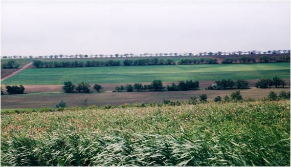
3. Shrub and Tree Planting:
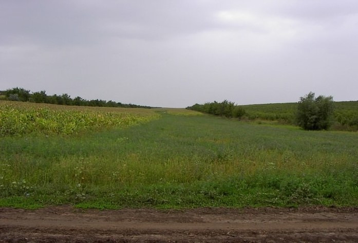
• 132 hectares of shelterbelts for water protection established; 112 hectares of improved anti-erosion forest belts set up; 50 hectares of improved pasture established; 484 hectares of the existing forests rehabilitated and properly managed; forest monitoring was incorporated into the general monitoring scheme.
4.Wetland Restoration and Promotion of Sustainable Management Practices:
The existing ecosystems were rehabilitated and ecologically well balanced. In this context two dams were built with a sluice gate system for the stabilization of water levels; three concrete bridges with adequate culvert capacity were installed for accessibility to different portions of the wetland; and 10 small wood bridges with culverts were built for access.
5 .Monitoring Soil and Water Quality and Environmental Impacts
Availability of water for downstream users and fisheries was increased, drinking water supplies was improved, there was increased quality and availability of groundwater for human and animal consumption, and simultaneously better productive lands with increased organic matter and carbon sequestration, as well as increased biodiversity.
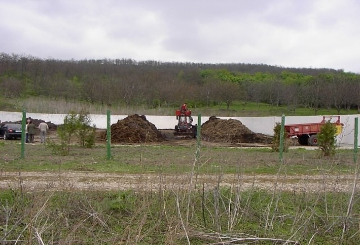
Key Elements of the Manure Management System:
a. Segregation of inert and recyclable materials from livestock waste through the provision of a separate household waste container.
b. Improved manure stores for storage of waste at a single impermeable store at the household with enough storage for up to one month's production.
c. Transfer of waste from the farm store to a central site, using transport units then unloading it at the commune platform, to aerate the waste, promoting continued bacterial activity.
d. At the commune/village store level, the segregated inert materials deposited in designated bunkers.
e. At the commune/village store level, management of the household manure at the main bunker involving stacking in shaped windrow heaps three metres high.
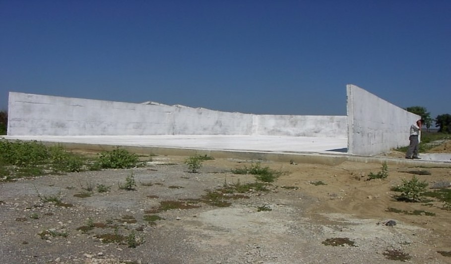
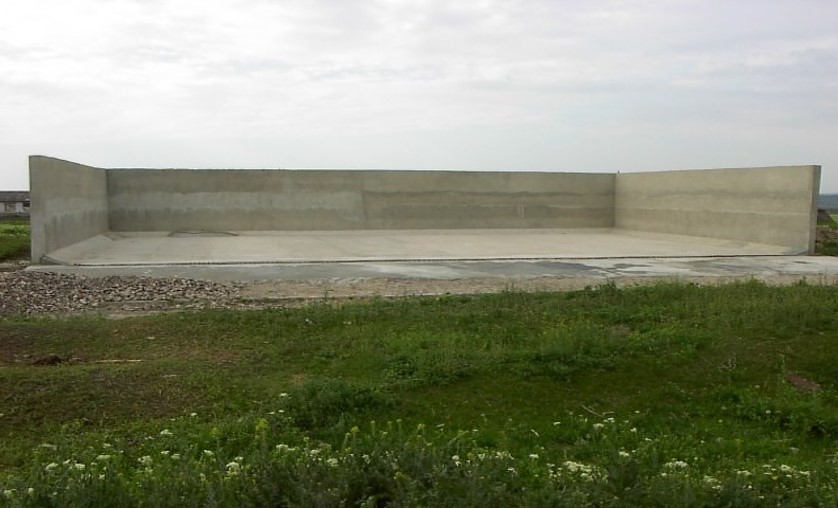
f. Store the waste deep so that the areas getting wet from rainfall is minimised. Provide impermeable walls and floor to eliminate leaching.
g. Provide storage capacity for over the winter so that matured manure will be available for use on the land.
Key Elements of facilities at the Village Platform are:
a. Concrete area for the management of the manure.
b. Bunkers for the segregated household manure.
c. Collecting channel for runoff from the platform.
d. Storage pits and tanks with impermeable base and walls.
e. Security fencing.
f. Office / Staff facilities and Landscaping. Monitoring wells to check for leakages.
Overall results show that 8,250 farmers from both the project pilot area and other regions of Moldova had adopted at least one environmentally-friendly agricultural practice promoted by the project, and had implemented these on 14,028 ha of land.
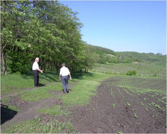
2.3 Photos of the Technology
Media Gallery
2.5 Country/ region/ locations where the Technology has been applied and which are covered by this assessment
Country:
Moldova, Republic of
Region/ State/ Province:
Hincesti and Orhei districts
Further specification of location:
Negrea, Lapusna, Carpineni, Minjir communes, Hincesti district; Sarata Razesti commune, Leova district, and Jora de Mijloc, Orhei district
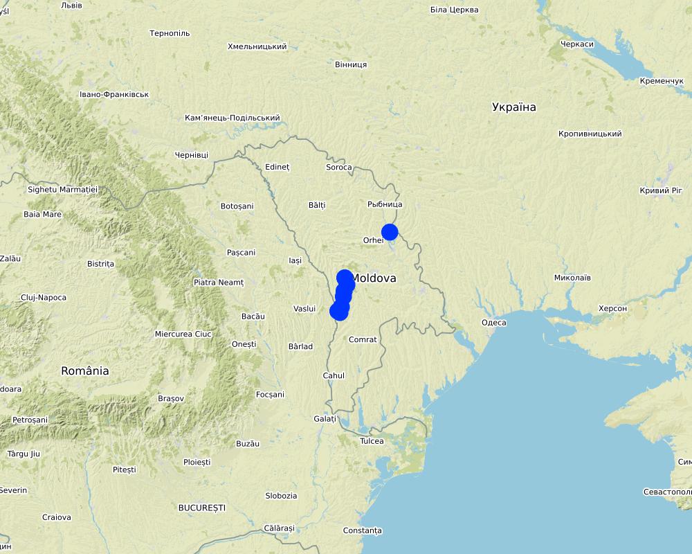
Map
×3. Classification of the SLM Technology
3.1 Main purpose(s) of the Technology
- improve production
- reduce, prevent, restore land degradation
- conserve ecosystem
- protect a watershed/ downstream areas – in combination with other Technologies
- preserve/ improve biodiversity
- reduce risk of disasters
- create beneficial economic impact
3.2 Current land use type(s) where the Technology is applied

Cropland
- Annual cropping
- Perennial (non-woody) cropping
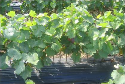
- Tree and shrub cropping
Main crops (cash and food crops):
Wheat, corn, sunflower, alfalfa (lucerne), vineyards, orchards, vegetables

Waterways, waterbodies, wetlands
- Drainage lines, waterways
- Swamps, wetlands
Main products/ services:
The existing ecosystems rehabilitated and ecologically well balanced; dams with a sluice gate system for the stabilization of water levels; concrete bridges with adequate culvert capacity for access to different portions of the wetland; and wooden bridges with culvert capacity for access through the zone constructed
3.3 Further information about land use
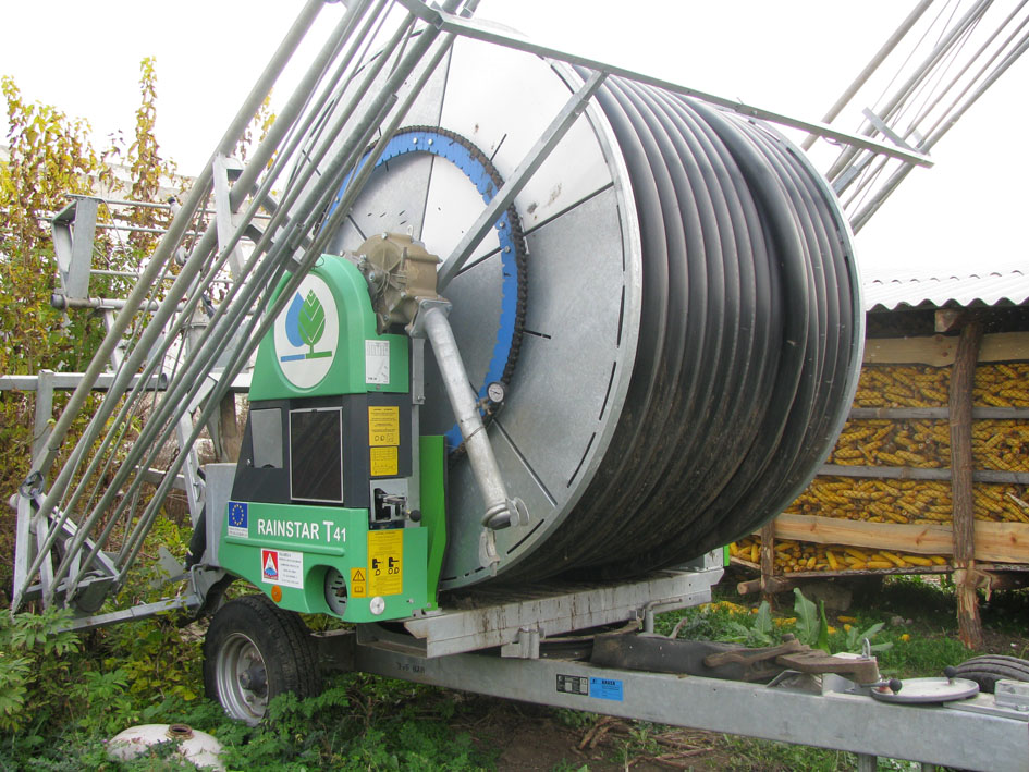
Water supply for the land on which the Technology is applied:
- mixed rainfed-irrigated
Number of growing seasons per year:
- 1
Specify:
1 growing season per year for rainfed and 2 growing seasons per year for irrigated areas
3.4 SLM group to which the Technology belongs
- forest plantation management
- rotational systems (crop rotation, fallows, shifting cultivation)
- integrated crop-livestock management
3.5 Spread of the Technology
Specify the spread of the Technology:
- evenly spread over an area
If the Technology is evenly spread over an area, indicate approximate area covered:
- > 10,000 km2
Comments:
8,250 farmers from both project pilot area and other regions of Moldova that adopted at least one environmentally friendly agricultural practice promoted by the project implemented on as much as 14,028 ha of land in total.
3.6 SLM measures comprising the Technology

agronomic measures
- A1: Vegetation/ soil cover
- A2: Organic matter/ soil fertility

vegetative measures
- V1: Tree and shrub cover
- V2: Grasses and perennial herbaceous plants
- V4: Replacement or removal of alien/ invasive species

management measures
- M2: Change of management/ intensity level
- M3: Layout according to natural and human environment
- M5: Control/ change of species composition
- M6: Waste management (recycling, re-use or reduce)
3.7 Main types of land degradation addressed by the Technology

soil erosion by water
- Wt: loss of topsoil/ surface erosion
- Wg: gully erosion/ gullying
- Wm: mass movements/ landslides
- Wr: riverbank erosion
- Wo: offsite degradation effects

chemical soil deterioration
- Cn: fertility decline and reduced organic matter content (not caused by erosion)
- Cp: soil pollution
- Cs: salinization/ alkalinization

physical soil deterioration
- Pc: compaction
- Pk: slaking and crusting
- Ps: subsidence of organic soils, settling of soil

biological degradation
- Bc: reduction of vegetation cover
- Bh: loss of habitats
- Bq: quantity/ biomass decline
- Bs: quality and species composition/ diversity decline
- Bl: loss of soil life

water degradation
- Ha: aridification
- Hp: decline of surface water quality
- Hq: decline of groundwater quality
- Hw: reduction of the buffering capacity of wetland areas
3.8 Prevention, reduction, or restoration of land degradation
Specify the goal of the Technology with regard to land degradation:
- prevent land degradation
- restore/ rehabilitate severely degraded land
4. Technical specifications, implementation activities, inputs, and costs
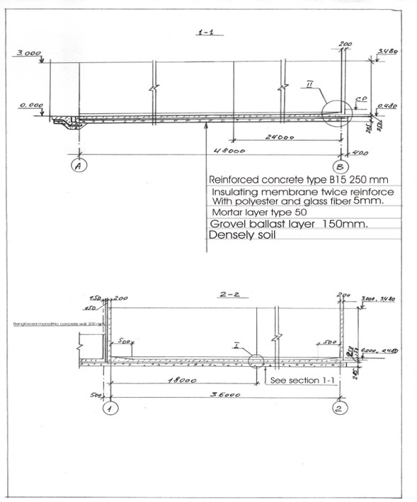
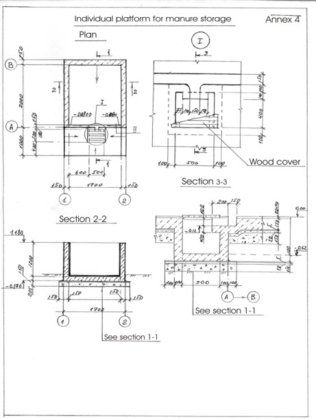
4.1 Technical drawing of the Technology
Author:
Ion Raileanu
Date:
01/07/2009
Author:
Ion Raileanu
Date:
02/07/2009
4.2 Technical specifications/ explanations of technical drawing
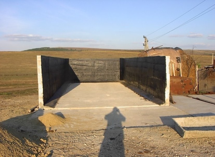
Schematic structure of village platform: Length - 48 m, Width - 36 m, Height - 3 m, Capacity - 3400 tons, Storage period - 5 months
Schematic structure of household platform: Length - 2.2 m, Height - 1.2 m, Capacity - 4.8 c.m., Storage period - 1 month.
At village level, the project supported the construction of waste storage platforms of 3400 tonnes capacity and a storage period of 5 months. The platform has 48 m length and 36 m width. It is surrounded by a concrete 3 m high wall and bedded by a concrete floor with an impermeable insolating membrane. The platform is equipped with a bunker for inert material and a basin for collection of liquid fraction. The platform is built on the commune land (administrated by the Mayoralty) in full compliance with the environmental protection requirements.
At the household-level 150 platforms were built. The platforms have 2.55 m3 and a storage period of one month. The platform capacity was calculated based on estimated quantity of manure for an average household with at least two cattle, two-three pigs and a certain number of poultry. The designed platform consists of a simple open fronted store with a concrete floor and 1.5 m height walls. In front of the platform, a concrete below ground tank (125 dcm3 volume) covered by a wood lid with a plastic basket inside of 50 liters capacity for collection of liquid fraction would be equipped. A separate small capacity container (about 90 liters) for the collection of recyclable and non-recyclable household wastes was also provided.
4.4 Establishment activities
| Activity | Type of measure | Timing | |
|---|---|---|---|
| 1. | Packages developed for manure management at village and household level and evaluated for replication | ||
| 2. | Public awareness & education | ||
| 3. | Use of good agricultural practices by farmer associations, family farms and individual farmers on cropland. | ||
| 4. | Monitoring & evaluation. |
4.7 Costs and inputs needed for maintenance/ recurrent activities (per year)
If land user bore less than 100% of costs, indicate who covered the remaining costs:
The Project
5. Natural and human environment
5.1 Climate
Annual rainfall
- < 250 mm
- 251-500 mm
- 501-750 mm
- 751-1,000 mm
- 1,001-1,500 mm
- 1,501-2,000 mm
- 2,001-3,000 mm
- 3,001-4,000 mm
- > 4,000 mm
Specify average annual rainfall (if known), in mm:
500.00
Indicate the name of the reference meteorological station considered:
Hincesti
Agro-climatic zone
- sub-humid
Climate is moderately continental: the summers are warm and long, with temperatures averaging about 20°C, and the winters are relatively mild and dry, with January temperatures averaging -4°C. Annual rainfall, which ranges from around 500 millimeters; long dry spells are not unusual. The heaviest rainfall occurs in summer; heavy showers and thunderstorms are common.
5.2 Topography
Slopes on average:
- flat (0-2%)
- gentle (3-5%)
- moderate (6-10%)
- rolling (11-15%)
- hilly (16-30%)
- steep (31-60%)
- very steep (>60%)
Landforms:
- plateau/plains
- ridges
- mountain slopes
- hill slopes
- footslopes
- valley floors
Altitudinal zone:
- 0-100 m a.s.l.
- 101-500 m a.s.l.
- 501-1,000 m a.s.l.
- 1,001-1,500 m a.s.l.
- 1,501-2,000 m a.s.l.
- 2,001-2,500 m a.s.l.
- 2,501-3,000 m a.s.l.
- 3,001-4,000 m a.s.l.
- > 4,000 m a.s.l.
Indicate if the Technology is specifically applied in:
- not relevant
Comments and further specifications on topography:
The territory belongs to the Central Moldova Height and the Plain of Upper Prut. The landscape is hilly, very fragmented with a dense network of valleys, hollows and plains. Almost 75% of the land is situated on slopes. Water erosion processes are widespread and quite intense. The predominant length of the hillsides in Negrea pilot area is 800-900 m.
5.3 Soils
Soil depth on average:
- very shallow (0-20 cm)
- shallow (21-50 cm)
- moderately deep (51-80 cm)
- deep (81-120 cm)
- very deep (> 120 cm)
Soil texture (topsoil):
- medium (loamy, silty)
Soil texture (> 20 cm below surface):
- medium (loamy, silty)
Topsoil organic matter:
- medium (1-3%)
If available, attach full soil description or specify the available information, e.g. soil type, soil PH/ acidity, Cation Exchange Capacity, nitrogen, salinity etc.
Chernozems (black soils) prevail in the soil composition (65% of the area) divided into argilo-illuvial and carbonate subtypes. These soils are perfectly suited for agriculture. They are friable, permeable, have good water and air saturation and are easy to till. Chernozems are rich in organic matter (3-4% humus content), however they are degraded. Alluvial soils are spread in the floodplain of the Lapusna river and its tributaries. alluvial soils are often subject to salinization and water logging.
5.4 Water availability and quality
Ground water table:
5-50 m
Availability of surface water:
medium
Water quality (untreated):
poor drinking water (treatment required)
Is water salinity a problem?
Yes
Specify:
high water mineralisation
Is flooding of the area occurring?
Yes
Regularity:
episodically
5.5 Biodiversity
Species diversity:
- low
Habitat diversity:
- low
5.6 Characteristics of land users applying the Technology
Sedentary or nomadic:
- Sedentary
Market orientation of production system:
- mixed (subsistence/ commercial
Off-farm income:
- 10-50% of all income
Relative level of wealth:
- poor
- average
Individuals or groups:
- individual/ household
- groups/ community
Level of mechanization:
- animal traction
- mechanized/ motorized
Gender:
- women
- men
Age of land users:
- elderly
Indicate other relevant characteristics of the land users:
The principal activity in the commune is agriculture. The farmers cultivate arable crops, grapes and fruits. From vegetables, pea and bean plantations, cabbage, cucumber, tomatoes, beats and carrots are most usual. Potatoes are predominantly cultivated on the households’ plots. There are two small economic units dealing with wood processing and meat production activating under the umbrella of the local farmer’s association, “SRL Negrea-Pomvit”. |
The income of the people depends much on the harvest and climatic conditions, but also on imbalances of the market, import policies, governmental purchases, etc. The estimated average income per capita in the community over the last 3 years was 45 US dollars per month.
5.7 Average area of land owned or leased by land users applying the Technology
- < 0.5 ha
- 0.5-1 ha
- 1-2 ha
- 2-5 ha
- 5-15 ha
- 15-50 ha
- 50-100 ha
- 100-500 ha
- 500-1,000 ha
- 1,000-10,000 ha
- > 10,000 ha
Is this considered small-, medium- or large-scale (referring to local context)?
- medium-scale
- large-scale
Comments:
The total number of land shares in the commune is 772. Each land share has on average 1.20 ha, including 0.70 ha of arable land, 0.15 ha of orchards and 0.35 ha of vineyards. The number of individual farms is 190. The principal landowner in the region is the association of shareholders “SRL Negrea-Pomvit”. The association manages collectively 664 ha. |
5.8 Land ownership, land use rights, and water use rights
Land ownership:
- communal/ village
- individual, titled
Land use rights:
- communal (organized)
- leased
Water use rights:
- open access (unorganized)
- individual
5.9 Access to services and infrastructure
health:
- poor
- moderate
- good
education:
- poor
- moderate
- good
technical assistance:
- poor
- moderate
- good
employment (e.g. off-farm):
- poor
- moderate
- good
markets:
- poor
- moderate
- good
energy:
- poor
- moderate
- good
roads and transport:
- poor
- moderate
- good
drinking water and sanitation:
- poor
- moderate
- good
financial services:
- poor
- moderate
- good
6. Impacts and concluding statements
6.1 On-site impacts the Technology has shown
Socio-economic impacts
Production
crop production
Comments/ specify:
According to elevator (NGO BIOS), •The SROI (Social Return on Investment) ratio for the period of 2004-2009 was 3,34, or, every $US1 invested by the Project $US 3,34 worth of value (economic, social and/or environmental) was delivered to society.
animal production
wood production
non-wood forest production
risk of production failure
land management
Water availability and quality
drinking water quality
water quality for livestock
irrigation water quality
Ecological impacts
Water cycle/ runoff
surface runoff
Soil
soil loss
soil compaction
nutrient cycling/ recharge
soil organic matter/ below ground C
Biodiversity: vegetation, animals
Vegetation cover
plant diversity
invasive alien species
habitat diversity
6.2 Off-site impacts the Technology has shown
downstream siltation
groundwater/ river pollution
buffering/ filtering capacity
damage on neighbours' fields
damage on public/ private infrastructure
Comments regarding impact assessment:
he Social Survey indicated an improved environmental situation in LPA in comparison to other rural localities. Some problems in LPA are not so acute as there were in 2002, especially soil erosion, aquatic reservoirs pollution and quality of potable water, which demonstrates the efficiency of APCP P|
The fact that over 50 % of the respondents from Lapusnita Pilot Area consider APCP implementation has a positive impact on life, health and environment, shows that APCP contributed substantially to the improving the economic, social and ecological conditions, especially in LPA. The acknowledged impa|
It is expected that the project will be scaled up at the national level and facilities for waste management will be improved in all communities; the value of manure will be appreciated and used as fertiliser, wetlands will be restored; environment-friendly practices, including reintroducing trees wi|
The level of applied good agricultural practices in LPA is higher than in other communities of the country and has increased as compared to 2003. Farmers apply more organic fertilizers (by 13%), forest belts (10%), strip cropping (9%) and less mineral fertilizers (17%).
ACSA organized 90 seminars. People from all districts attended the training seminars. Survey data show that 90 % of the participants in seminars intended to apply GAP.
Over 3,000 farmers adopted at least 1 of GAP in Lapusnita Pilot Area and over 12,000 outside LPA. The total area, where environmentally-friendly practices were applied was 28,275 ha.
6.3 Exposure and sensitivity of the Technology to gradual climate change and climate-related extremes/ disasters (as perceived by land users)
Comments:
Healthy organisms are adapted easily to various conditions. In this way agro-ecosystems having soils and water with improved properties (due to application of good agricultural practices) with adequate management practices will have also positively impact on climate change adaptation.
Due to the fact that Good Agricultural practices improve soil and water qualities, they create very good conditions for the development of soil biodiversity and wild biodiversity in farming landscapes. Due to the reduction of pollution landscapes become more healthy and also is very beneficial for the agricultural biodiversity.
Permanent vegetated strips established at field and stream riparian boundaries and in water courses will create conditions for the development of biodiversity.|
Conventional agriculture is the major contributor to increasing of methane and nitrous oxide concentrations in earth's atmosphere. Aforestation and soil conservation technologies are one of the main sink of carbon dioxide. In this way good agricultural practices have a positively impact on climate change mitigation.
6.4 Cost-benefit analysis
How do the benefits compare with the establishment costs (from land users’ perspective)?
Short-term returns:
slightly positive
Long-term returns:
positive
How do the benefits compare with the maintenance/ recurrent costs (from land users' perspective)?
Short-term returns:
neutral/ balanced
Long-term returns:
positive
6.5 Adoption of the Technology
- 10-50%
If available, quantify (no. of households and/ or area covered):
8,250 farmers from both project pilot area and other regions of Moldova
Of all those who have adopted the Technology, how many have did so spontaneously, i.e. without receiving any material incentives/ payments?
- 10-50%
6.6 Adaptation
Has the Technology been modified recently to adapt to changing conditions?
No
6.8 Weaknesses/ disadvantages/ risks of the Technology and ways of overcoming them
| Weaknesses/ disadvantages/ risks in the land user’s view | How can they be overcome? |
|---|---|
| Farmers did not calculate properly expenses and benefits. | They should be provided simple instruments to calculate their inputs and to plan for future activity. |
| Agricultural literature is too difficult for rural people to understand. | Knowledge should be provided in an accessible manner. Small guides should exist for separate crops with drawings and schemes. |
7. References and links
7.1 Methods/ sources of information
- interviews with land users
300
7.2 References to available publications
Title, author, year, ISBN:
Guidelines for Good Agricultural Practices (Practici agricole prietenoase mediului). Îndrumar: /Ungureanu V., Cerbari V., Magdîl A., Gherman E.- Chişinău: Tipografia Centrală, 2006. – 96 p.
Available from where? Costs?
http://www.acsa.md/album.php?l=ro&idc=152&t=/GALERIE-FOTO/Practici-agricole-prietenoase-mediului
7.3 Links to relevant information which is available online
Title/ description:
Moldova - Agricultural Pollution Control Project (English)
URL:
http://documents.worldbank.org/curated/en/117701468287732017/Moldova-Agricultural-Pollution-Control-Project
Links and modules
Expand all Collapse allLinks
No links
Modules
No modules