Longan, Plum interplanting [China]
- Creation:
- Update:
- Compiler: zhangsheng LIU
- Editor: –
- Reviewers: David Streiff, Alexandra Gavilano
Development of Southward Fruit Trees
technologies_942 - China
View sections
Expand all Collapse all1. General information
1.2 Contact details of resource persons and institutions involved in the assessment and documentation of the Technology
Name of the institution(s) which facilitated the documentation/ evaluation of the Technology (if relevant)
Water & Soil Conservation Office of Zhaoan County (Water & Soil Conservation Office of Zhaoan County) - China1.3 Conditions regarding the use of data documented through WOCAT
The compiler and key resource person(s) accept the conditions regarding the use of data documented through WOCAT:
Yes
1.5 Reference to Questionnaire(s) on SLM Approaches (documented using WOCAT)
Interplanting fruit trees of Longan, Peach, Plum etc. [China]
Interplanting plum, peach and other fruit trees in longan orchard on level terraces in order to prevent soil and water loss and improve production of the fruit trees.
- Compiler: zhangsheng LIU
2. Description of the SLM Technology
2.1 Short description of the Technology
Definition of the Technology:
Interplanting plum, peach in the Longan orchard to conserve soil and water and improve soil fertility.
2.2 Detailed description of the Technology
Description:
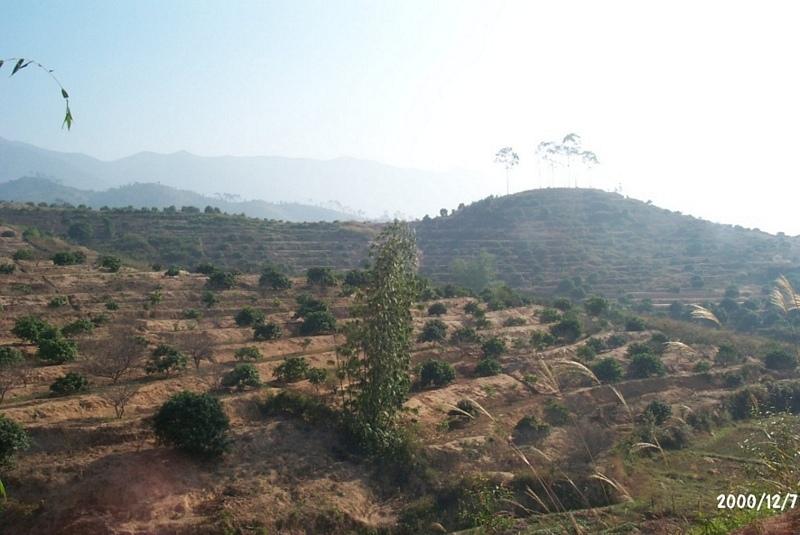
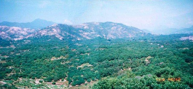
The technology is to interplant fruit trees in orchard so as to prevent water loss and soil erosion. To implement the project, local government gave financial support and SWC specialists gave technologically guide to local land users. The slope land in the hilly and mountain areas were constructed into terraces and plant trees in order to improve surface vegetation cover rate and reduce water and soil loss; the harvesting surplus rainfall in the raining season and irrigate the fruit trees in dry seasons.
2.3 Photos of the Technology
Media Gallery
2.5 Country/ region/ locations where the Technology has been applied and which are covered by this assessment
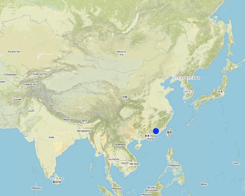
Country:
China
Region/ State/ Province:
Fujian
Specify the spread of the Technology:
- evenly spread over an area
If precise area is not known, indicate approximate area covered:
- 10-100 km2
Comments:
After the land users' arduously cultivating over many years, the former waste mountains have become a picture of vital force, the various growing fruit trees are very vital, water loss & soil erosion is controlled, and cultivated land can be used in a sustainable way.
Map
×2.6 Date of implementation
If precise year is not known, indicate approximate date:
- more than 50 years ago (traditional)
2.7 Introduction of the Technology
Specify how the Technology was introduced:
- through projects/ external interventions
Comments (type of project, etc.):
The technology originated from Institute of Water & Soil Conservation in Taiwan and improved by the national SWC specialists.
3. Classification of the SLM Technology
3.1 Main purpose(s) of the Technology
- reduce, prevent, restore land degradation
3.2 Current land use type(s) where the Technology is applied
Land use mixed within the same land unit:
Yes
Specify mixed land use (crops/ grazing/ trees):
- Agroforestry

Cropland
- Annual cropping
- Perennial (non-woody) cropping
- Tree and shrub cropping
Tree and shrub cropping - Specify crops:
- stone fruits (peach, apricot, cherry, plum, etc)
Number of growing seasons per year:
- 2
Specify:
Longest growing period in days: 240Longest growing period from month to month: Mar - OctSecond longest growing period in days: 120Second longest growing period from month to month: Nov - Feb
Is intercropping practiced?
Yes
If yes, specify which crops are intercropped:
Interplanting plum, peach

Forest/ woodlands
Products and services:
- Timber
- Fuelwood
- Fruits and nuts
Comments:
Major land use problems (compiler’s opinion): The ground surface of the SWC application area did not plant grass and green manure. The soil in the mountaintop area is lean, where broadleaf forest could be planted.
Major land use problems (land users’ perception): Because the soil layer is thin and poor, the local farmers wouldn't like to invest in the area where water loss and soil erosion is serious.
Problems / comments regarding forest use: Commonly, supplementary planting of trees in the following Spring.
3.4 Water supply
Water supply for the land on which the Technology is applied:
- rainfed
3.5 SLM group to which the Technology belongs
- cross-slope measure
3.6 SLM measures comprising the Technology

vegetative measures
- V1: Tree and shrub cover
Comments:
Type of agronomic measures: mixed cropping / intercropping, contour ridging
3.7 Main types of land degradation addressed by the Technology

soil erosion by water
- Wt: loss of topsoil/ surface erosion
- Wg: gully erosion/ gullying
Comments:
Main type of degradation addressed: Wt: loss of topsoil / surface erosion
Secondary types of degradation addressed: Wg: gully erosion / gullying
Main causes of degradation: over-exploitation of vegetation for domestic use (Causing land surface bare, ruderal cluster.), poverty / wealth (Lack of captial: hindering ulterior expanding of the water and soil conservation)
Secondary causes of degradation: Land subdivision (seperated land area can not be entirely developed)
3.8 Prevention, reduction, or restoration of land degradation
Specify the goal of the Technology with regard to land degradation:
- reduce land degradation
4. Technical specifications, implementation activities, inputs, and costs
4.1 Technical drawing of the Technology
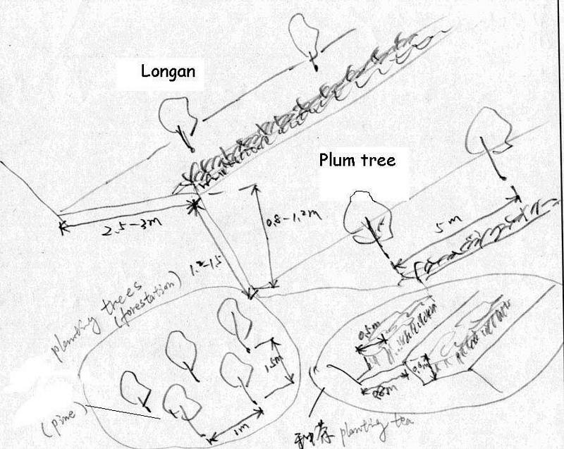
Technical specifications (related to technical drawing):
Technical drawing of interplanting in orchard.
Location: Zhaoan county. Fujian
Date: 1997
Technical knowledge required for field staff / advisors: moderate
Technical knowledge required for land users: low
Main technical functions: control of dispersed runoff: impede / retard
Secondary technical functions: reduction of slope angle, improvement of ground cover, wind-break
Mixed cropping / intercropping
Material/ species: Plum trees
Quantity/ density: 238
Remarks: increasing ground cover
Contour ridging
Remarks: reasonable layout
Trees/ shrubs species: jequirity tree
Perennial crops species: Plum, peach lichi trees
Slope (which determines the spacing indicated above): 30.00%
If the original slope has changed as a result of the Technology, the slope today is (see figure below): 15.00%
Gradient along the rows / strips: 60.00%
Construction material (earth): cheaper, local materials, good effect
Slope (which determines the spacing indicated above): 28.00%
If the original slope has changed as a result of the Technology, the slope today is: 13.00%
Lateral gradient along the structure: 26.00%
For water harvesting: the ratio between the area where the harvested water is applied and the total area from which water is collected is: 1:2.00
Vegetation is used for stabilisation of structures.
Change of land use practices / intensity level: Forbidding disafforest in mountain areas for 3 years.
Author:
LIU Zhangsheng, Zhaoan, China
4.2 General information regarding the calculation of inputs and costs
Specify currency used for cost calculations:
- USD
If relevant, indicate exchange rate from USD to local currency (e.g. 1 USD = 79.9 Brazilian Real): 1 USD =:
8.3
Indicate average wage cost of hired labour per day:
2.40
4.3 Establishment activities
| Activity | Timing (season) | |
|---|---|---|
| 1. | plant trees | spring |
| 2. | Level off land | winter |
| 3. | weed | winter |
| 4. | digging ditch | spring |
| 5. | Level off land | Autumn |
| 6. | costruct bank of field | winter |
| 7. | Closure and forbidding disafforest | 3 years |
4.4 Costs and inputs needed for establishment
Comments:
Duration of establishment phase: 24 month(s)
4.5 Maintenance/ recurrent activities
| Activity | Timing/ frequency | |
|---|---|---|
| 1. | digging ditch(interplant) | winter / Annually |
| 2. | irrigate | spring / Each cropping season |
| 3. | fertilization | Mar.Jun.Sep. /Annual |
| 4. | spew pesticide | Apl.Jul. /Annual |
| 5. | reinforce banks of level terrace | autumn/Annual |
| 6. | complementing seedling | spring / 1 |
| 7. | Fertilizing | Mar. Jun. / 2 |
4.6 Costs and inputs needed for maintenance/ recurrent activities (per year)
Comments:
Slope angle degree, and earth volume being moved.
4.7 Most important factors affecting the costs
Describe the most determinate factors affecting the costs:
Main factor influencing the SWC cost is steeper slope. Since the slope steeper is, much more cost needed to level off terrace. In some places, the earth needs to be moved from one place to another which will spend a lot of labor forces.
5. Natural and human environment
5.1 Climate
Annual rainfall
- < 250 mm
- 251-500 mm
- 501-750 mm
- 751-1,000 mm
- 1,001-1,500 mm
- 1,501-2,000 mm
- 2,001-3,000 mm
- 3,001-4,000 mm
- > 4,000 mm
Agro-climatic zone
- humid
- sub-humid
5.2 Topography
Slopes on average:
- flat (0-2%)
- gentle (3-5%)
- moderate (6-10%)
- rolling (11-15%)
- hilly (16-30%)
- steep (31-60%)
- very steep (>60%)
Landforms:
- plateau/plains
- ridges
- mountain slopes
- hill slopes
- footslopes
- valley floors
Altitudinal zone:
- 0-100 m a.s.l.
- 101-500 m a.s.l.
- 501-1,000 m a.s.l.
- 1,001-1,500 m a.s.l.
- 1,501-2,000 m a.s.l.
- 2,001-2,500 m a.s.l.
- 2,501-3,000 m a.s.l.
- 3,001-4,000 m a.s.l.
- > 4,000 m a.s.l.
Indicate if the Technology is specifically applied in:
- not relevant
Comments and further specifications on topography:
slopes on average also moderate
5.3 Soils
Soil depth on average:
- very shallow (0-20 cm)
- shallow (21-50 cm)
- moderately deep (51-80 cm)
- deep (81-120 cm)
- very deep (> 120 cm)
Soil texture (topsoil):
- coarse/ light (sandy)
- medium (loamy, silty)
Soil texture (> 20 cm below surface):
- coarse/ light (sandy)
- medium (loamy, silty)
Topsoil organic matter:
- medium (1-3%)
- low (<1%)
If available, attach full soil description or specify the available information, e.g. soil type, soil PH/ acidity, Cation Exchange Capacity, nitrogen, salinity etc.
Soil depth als moderatly deep
Soil fertility very low - medium
Soil drainage / infiltration medium - good
Soil water storage capacity medium - high
5.6 Characteristics of land users applying the Technology
Off-farm income:
- 10-50% of all income
Relative level of wealth:
- rich
Level of mechanization:
- manual work
- animal traction
Indicate other relevant characteristics of the land users:
Population density: 100-200 persons/km2
Annual population growth: 0.5% - 1%
12% of the land users are very rich and own 12% of the land.
44% of the land users are rich and own 44% of the land.
35% of the land users are average wealthy and own 35% of the land.
9% of the land users are poor and own 9% of the land.
Off-farm income specification: Mainly in transport of goods and travelers, such as transport service. It needs much more idle labor forces.
5.8 Land ownership, land use rights, and water use rights
Land ownership:
- state
- individual, not titled
Land use rights:
- leased
6. Impacts and concluding statements
6.4 Cost-benefit analysis
How do the benefits compare with the establishment costs (from land users’ perspective)?
Short-term returns:
slightly negative
Long-term returns:
very positive
How do the benefits compare with the maintenance/ recurrent costs (from land users' perspective)?
Short-term returns:
neutral/ balanced
Long-term returns:
very positive
6.5 Adoption of the Technology
- > 50%
If available, quantify (no. of households and/ or area covered):
1253 households
Of all those who have adopted the Technology, how many did so spontaneously, i.e. without receiving any material incentives/ payments?
- 51-90%
Comments:
80% of land user families have adopted the Technology with external material support
690 land user families have adopted the Technology with external material support
Comments on acceptance with external material support: survey results
20% of land user families have adopted the Technology without any external material support
563 land user families have adopted the Technology without any external material support
Comments on spontaneous adoption: survey results
There is a moderate trend towards spontaneous adoption of the Technology
Comments on adoption trend: The farmers have known that the SWC technology could produce benefits of improving agricultural production.
7. References and links
7.1 Methods/ sources of information
Links and modules
Expand all Collapse allLinks
Interplanting fruit trees of Longan, Peach, Plum etc. [China]
Interplanting plum, peach and other fruit trees in longan orchard on level terraces in order to prevent soil and water loss and improve production of the fruit trees.
- Compiler: zhangsheng LIU
Modules
No modules