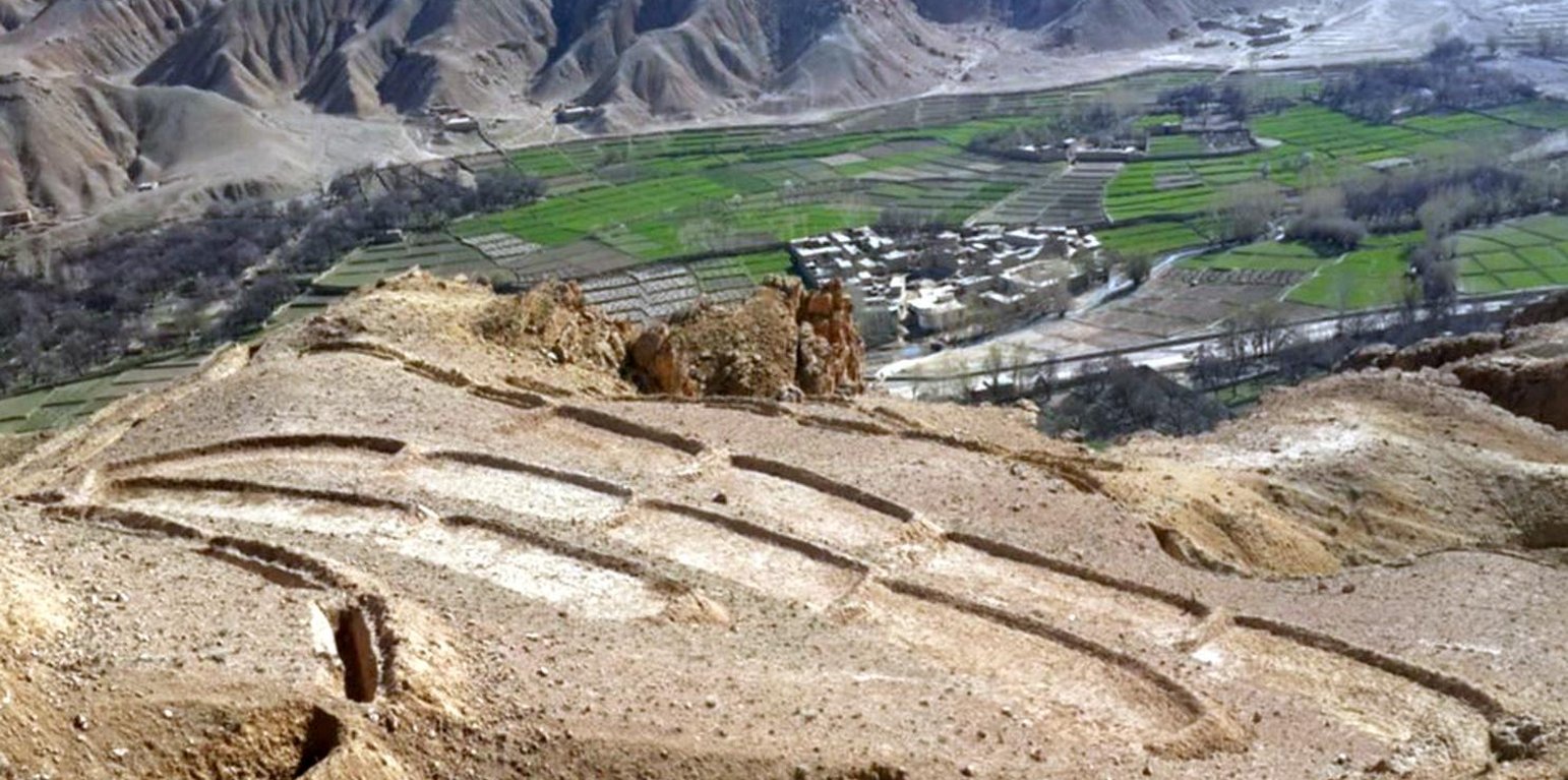
Overview of constructed terraces in the watershed, Saighan district, Bamyan (Shabir Shahem (HELVETAS Swiss Intercooperation, Afghanistan))

Terracing in Watershed (Afganistán)

Kordak dar Abriza

Descripción

Reshaping unproductive land into a series of levelled, gently-sloping platforms creates conditions suitable for cultivation and prevents accelerated erosion.

The terracing in watershed fact-sheet is documented by Sustainable Land Management Project/HELVETAS Swiss Intercooperation which is funded by Swiss Agency for Development and Cooperation (SDC).
Due to the enduring conflict and to the breakdown of common-pool resources management in upper catchments areas over the past decades, most pastures in Afghanistan are degraded.
Uncontrolled grazing of animals tilling grazing land to grow cereal crops are the main contributors to the loss of vegetation coverage in the upper catchments. One of the negative consequences is repeated flash floods each year causing loss and damage of agriculture lands, gardens, road, canal, infrastructure, houses and even lives. To decrease the severity of flash floods and extend vegetation in upper catchment areas, HELVETAS Swiss Intercooperation in Saighan district has established watershed activities.

Purpose of the Technology: Terrace construction was identified as an effective measure in degraded watershed areas to:
•control runoff and decrease flash flood;
•increase water infiltration;
•create the opportunity for income from cultivation of valuable crops in the terraces.

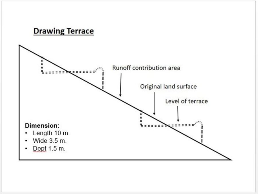
Establishment / maintenance activities and inputs: Having selected the watersheds and established watershed committees, watershed master plans were prepared and various structural and agronomical measures identified and estimated for each unit of land. Community laborers, trained by HELVETAS technical staff, constructed the terraces under supervision of watershed committee members. 600 terraces, each measuring 10 m x 3.6 m were constructed on seven hectares of land. To ensure maintenance, HELVETAS Swiss Intercooperation facilitated the creation of community saving systems and invested 10% of the project budget for maintenance of each watershed. It improved the capacity of watershed members, so after ending project support the community watershed committee would be able to manage maintenance of watershed measures.


Natural / human environment: Bamyan province is a remote province of Afghanistan with a high poverty rate. It has a semi-arid climate with cold winters and hot and dry summers. During winter, temperatures can drop below -22 degrees. Summer temperatures can reach 34 degrees in the month of July. The average annual rainfall in the area is about 230mm and some years can be very dry. 90% of the population relies on subsistence agriculture for their livelihoods and off-farm activities are marginal. The soil texture is clay, sandy loam and clay loam with moderate type of soil fertility, naked area of upper catchments causes that most of Saighan villages face to water scarcity during May to September and can’t grow valuable crops.The growing season in Saighan district is relatively short from April to October and farmers can produce only one crop per year. Farmers with access to irrigation water cultivate cash crops, for example potato and vegetables, in addition to staple crops (wheat) and fodder crops.Those without access to irrigation water cultivate wheat and fodder crops only. Water scarcity during May to September may result in a lack of high value crops.
The average annual income from one hectare in the area of having enough irrigation water is 250000 AFN (3676 USD) and in the area which has no enough irrigation water is 67500 AFN (992 USD).

Lugar

Lugar: Saighan, Bamyan, Afganistán

No. de sitios de Tecnología analizados:

Georreferencia de sitios seleccionados
  • n.d.

Difusión de la Tecnología: distribuida parejamente sobre un área (approx. 1-10 km2)

¿En un área de protección permanente?:

Fecha de la implementación: hace menos de 10 años (recientemente)

Tipo de introducción
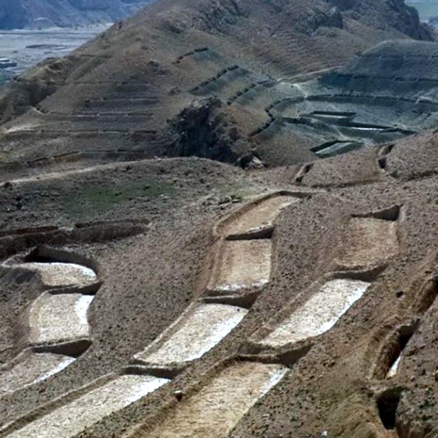
Close view of constructed terraces in the watershed (Shabir Shahem (HELVETAS Swiss Intercooperation, Afghanistan))

Clasificación de la Tecnología

Propósito principal
  • mejorar la producción
  • reducir, prevenir, restaurar la degradación de la tierra
  • conservar el ecosistema
  • proteger una cuenca hidrográfica/ áreas corriente abajo – en combinación con otras Tecnologías
  • preservar/ mejorar biodiversidad
  • reducir el riesgo de desastres naturales
  • adaptarse al cambio climático/ extremos climáticos y sus impactos
  • mitigar cambio climático y sus impactos
  • crear impacto económico benéfico
  • crear impacto social benéfico
Uso de tierra

  • Tierras cultivadas
    • Cultivos perennes (no leñosos)
    Número de temporadas de cultivo por año: 1
  • Tierra de pastoreo
    • Nomadismo

Provisión de agua
  • de secano
  • mixta de secano – irrigada
  • totalmente irrigada

Propósito relacionado a la degradación de las tierras
  • prevenir la degradación de la tierra
  • reducir la degradación de la tierra
  • restaurar/ rehabilitar tierra severamente degradada
  • adaptarse a la degradación de la tierra
  • no aplica
La degradación considerada
  • erosión de suelos por agua - Wt: pérdida de capa arable/ erosión de la superficie
Grupo MST
  • medida de pendiente transversal
Medidas MST
  • medidas estructurales - S1: Terrazas

Dibujo técnico

Especificaciones técnicas
Technical drawing of a terrace built in the watershed for the mean of vegetation.
Almost all the terraces constructed on the hill sides has 10 m length, 3.5 m width and 1.5 m depth.

Location: Saighan. Bamyan

Date: 19/04/2016

Technical knowledge required for field staff / advisors: high (In order to design well)

Technical knowledge required for land users: low

Main technical functions: control of dispersed runoff: impede / retard, reduction of slope angle, reduction of slope length, improvement of topsoil structure (compaction), increase of infiltration, increase / maintain water stored in soil, promotion of vegetation species and varieties (quality, eg palatable fodder)

Terrace: forward sloping
Vertical interval between structures (m): 1.8
Spacing between structures (m): 0.5
Depth of ditches/pits/dams (m): 0.3
Width of ditches/pits/dams (m): 3.6
Length of ditches/pits/dams (m): 10

Construction material (earth): Excuvation of soil and leveling

Slope (which determines the spacing indicated above): 15-30%

If the original slope has changed as a result of the Technology, the slope today is: 0%

Lateral gradient along the structure: 0%

Specification of dams/ pans/ ponds: Capacity 36m3

Catchment area: 36m2
Author: Shabir Shahem, HELVETAS Swiss Intercooperation, Afghanistan

Establecimiento/ mantenimiento: actividades, insumos y costos

Cálculo de insumos y costos
  • Los costos se calculan:
  • Moneda usada para calcular costos: USD
  • Tasa de cambio (a USD): 1 USD = n.d.
  • Costo promedio por día del sueldo de la mano de obra contratada: 5.88
Factores más determinantes que afectan los costos
Labor cost is the determinate factors which was affecting the costs.
Actividades de establecimiento
  1. Labor cost for the construction of the terraces (Momento/ frequencia: 1 month)
Insumos y costos para establecimiento
Especifique insumo Unidad Cantidad Costos por unidad (USD) Costos totales por insumo (USD) % de los costos cubiertos por los usuarios de las tierras
Mano de obra
Labor cost for the construction of the terraces persons/day 1200,0 5,88 7056,0 10,0
Costos totales para establecer la Tecnología 7'056.0
Costos totales para establecer la Tecnología en USD 7'056.0
Actividades de mantenimiento
  1. Repairing of few terraces after heavy rain falls (Momento/ frequencia: 3 times a year)
Insumos y costos de mantenimiento
Especifique insumo Unidad Cantidad Costos por unidad (USD) Costos totales por insumo (USD) % de los costos cubiertos por los usuarios de las tierras
Mano de obra
Repairing of few terraces persons/day 6,0 5,833333 35,0 100,0
Indique los costos totales para mantenecer la Tecnología 35.0
Costos totales para mantener la Tecnología en USD 35.0

Entorno natural

Promedio anual de lluvia
  • < 250 mm
  • 251-500 mm
  • 501-750 mm
  • 751-1,000 mm
  • 1,001-1,500 mm
  • 1,501-2,000 mm
  • 2,001-3,000 mm
  • 3,001-4,000 mm
  • > 4,000 mm
Zona agroclimática
  • húmeda
  • Sub-húmeda
  • semi-árida
  • árida
Especificaciones sobre el clima
Thermal climate class: temperate
Pendiente
  • plana (0-2 %)
  • ligera (3-5%)
  • moderada (6-10%)
  • ondulada (11-15%)
  • accidentada (16-30%)
  • empinada (31-60%)
  • muy empinada (>60%)
Formaciones telúricas
  • meseta/ planicies
  • cordilleras
  • laderas montañosas
  • laderas de cerro
  • pies de monte
  • fondo del valle
Altura
  • 0-100 m s.n.m.
  • 101-500 m s.n.m.
  • 501-1,000 m s.n.m
  • 1,001-1,500 m s.n.m
  • 1,501-2,000 m s.n.m
  • 2,001-2,500 m s.n.m
  • 2,501-3,000 m s.n.m
  • 3,001-4,000 m s.n.m
  • > 4,000 m s.n.m
La Tecnología se aplica en
  • situaciones convexas
  • situaciones cóncavas
  • no relevante
Profundidad promedio del suelo
  • muy superficial (0-20 cm)
  • superficial (21-50 cm)
  • moderadamente profunda (51-80 cm)
  • profunda (81-120 cm)
  • muy profunda (>120 cm)
Textura del suelo (capa arable)
  • áspera/ ligera (arenosa)
  • mediana (limosa)
  • fina/ pesada (arcilla)
Textura del suelo (> 20 cm debajo de la superficie)
  • áspera/ ligera (arenosa)
  • mediana (limosa)
  • fina/ pesada (arcilla)
Materia orgánica de capa arable
  • elevada (>3%)
  • media (1-3%)
  • baja (<1%)
Agua subterránea
  • en superficie
  • < 5 m
  • 5-50 m
  • > 50 m
Disponibilidad de aguas superficiales
  • excesiva
  • bueno
  • mediana
  • pobre/ ninguna
Calidad de agua (sin tratar)
  • agua potable de buena calidad
  • agua potable de mala calidad (requiere tratamiento)
  • solo para uso agrícola (irrigación)
  • inutilizable
La calidad de agua se refiere a:
¿La salinidad del agua es un problema?
  • No

Incidencia de inundaciones
  • No
Diversidad de especies
  • elevada
  • mediana
  • baja
Diversidad de hábitats
  • elevada
  • mediana
  • baja

Las características de los usuarios de la tierra que aplican la Tecnología

Orientación del mercado
  • subsistencia (autoprovisionamiento)
  • mixta (subsistencia/ comercial)
  • comercial/ mercado
Ingresos no agrarios
  • menos del 10% de todos los ingresos
  • 10-50% de todo el ingreso
  • > 50% de todo el ingreso
Nivel relativo de riqueza
  • muy pobre
  • pobre
  • promedio
  • rico
  • muy rico
Nivel de mecanización
  • trabajo manual
  • tracción animal
  • mecanizado/motorizado
Sedentario o nómada
  • Sedentario
  • Semi-nómada
  • Nómada
Individuos o grupos
  • individual/ doméstico
  • grupos/ comunal
  • cooperativa
  • empleado (compañía, gobierno)
Género
  • mujeres
  • hombres
Edad
  • niños
  • jóvenes
  • personas de mediana edad
  • ancianos
Área usada por hogar
  • < 0.5 ha
  • 0.5-1 ha
  • 1-2 ha
  • 2-5 ha
  • 5-15 ha
  • 15-50 ha
  • 50-100 ha
  • 100-500 ha
  • 500-1,000 ha
  • 1,000-10,000 ha
  • > 10,000 ha
Escala
  • pequeña escala
  • escala mediana
  • gran escala
Tenencia de tierra
  • estado
  • compañía
  • comunitaria/ aldea
  • grupal
  • individual, sin título
  • individual, con título
Derechos de uso de tierra
  • acceso abierto (no organizado)
  • comunitarios (organizado)
  • arrendamiento
  • individual
Derechos de uso de agua
  • acceso abierto (no organizado)
  • comunitarios (organizado)
  • arrendamiento
  • individual
Acceso a servicios e infraestructura
salud

pobre
bueno
educación

pobre
bueno
asistencia técnica

pobre
bueno
empleo (ej. fuera de la granja)

pobre
bueno
mercados

pobre
bueno
energía

pobre
bueno
caminos y transporte

pobre
bueno
agua potable y saneamiento

pobre
bueno
servicios financieros

pobre
bueno

Impacto

Impactos socioeconómicos
Producción de cultivo
disminuyó
incrementó

Cantidad antes de MST: 60
Cantidad luego de MST: 80
Technology reduce flood and lower lands doesnt effect by floods

disponibilidad de agua para irrigar
disminuyó
incrementó

Cantidad antes de MST: 20
Cantidad luego de MST: 25
Increasing under ground water by applying technology

ingreso agrario
disminuyó
incrementó

Cantidad antes de MST: 0
Cantidad luego de MST: 50
Cultivation of cash crop in the terraces (farm income from uplands)

Impactos socioculturales
seguridad alimentaria/ autosuficiencia
disminuyó
mejoró

MST/ conocimiento de la degradación de la tierra
disminuyó
mejoró

mitigación de conflicto
empeoró
mejoró

situación de grupos en desventaja social y económica (género, etáreo, estatus, etnicidad, etc.)
empeoró
mejoró

livelihood and human well-being
reduced
improved


The technology has effective role on reducing flash flood and as well through cultivation of valuable crops the community get more income from watershed area

Impactos ecológicos
cosecha/recolección de agua (escurrimiento, rocío, nieve, etc.)
disminuyó
mejoró

escurrimiento superficial
incrementó
disminuyó

Cantidad antes de MST: 0
Cantidad luego de MST: 100
Leveled terraces infilter the water

nivel freático/ acuífero
disminuyó
recargó

humedad del suelo
disminuyó
incrementó

Cantidad antes de MST: 0
Cantidad luego de MST: 50
Technology let the water infilteration more

cubierta del suelo
disminuyó
mejoró

pérdida de suelo
incrementó
disminuyó

Impactos fuera del sitio
disponibilidad de agua (aguas subterráneas, manantiales)
disminuyó
incrementó

inundaciones río abajo (no deseadas)
incrementó
disminuyó

Cantidad antes de MST: 0
Cantidad luego de MST: 50
Control runoff

Análisis costo-beneficio

Beneficios comparados con los costos de establecimiento
Ingresos a corto plazo:
muy negativo
muy positivo

Ingresos a largo plazo
muy negativo
muy positivo

Beneficios comparados con costos de mantenimiento
Ingresos a corto plazo:
muy negativo
muy positivo

Ingresos a largo plazo
muy negativo
muy positivo

The establishment cost of this technology seems to be high but once they are built they need very less maintenance cost with lots of benefits in the other hand.

Cambio climático

Cambio climático gradual
temperatura anual incrementó

nada bien
muy bien
Extremos (desastres) relacionados al clima
tormenta de lluvia local

nada bien
muy bien
sequía

nada bien
muy bien
inundación general (río)

nada bien
muy bien

Adopción y adaptación

Porcentaje de usuarios de la tierra que adoptaron la Tecnología
  • casos individuales / experimentales
  • 1-10%
  • 11-50%
  • > 50%
De todos quienes adoptaron la Tecnología, ¿cuántos lo hicieron sin recibir incentivos/ pagos materiales?
  • 0-10%
  • 11-50%
  • 51-90%
  • 91-100%
Número de hogares y/ o área cubierta
444 households covering 100 percent of the stated area
¿La tecnología fue modificada recientemente para adaptarse a las condiciones cambiantes?
  • No
¿A qué condiciones cambiantes?
  • cambios climáticos / extremos
  • mercados cambiantes
  • disponibilidad de mano de obra (ej. debido a migración)

Conclusiones y lecciones aprendidas

Fortalezas: perspectiva del usuario de tierras
  • Good measure that is easy to be applied by the people.

    How can they be sustained / enhanced? Conducting training and workshops for capacity building of the community members.
  • The application of this technology results to the control of runoff and reduction of the flash flood.

    How can they be sustained / enhanced? More vegetative measures should be considered.
Fortalezas: punto de vista del compilador o de otra persona recurso clave
  • A good technology for the better control of runoff and keeping the moisture.

    How can they be sustained / enhanced? Cultivation and sustainable maintenance of the plants in the terraces.
  • Preparing and providing a good and proper place for cultivation and plantation.

    How can they be sustained / enhanced? Plantation of the local plants which has more resistance and are adaptable to the natural environment of Saighan district.
  • Getting more income through cultivation of valuable crops.

    How can they be sustained / enhanced? Protection of cultivated seed from grazing animals
Debilidades/ desventajas/ riesgos: perspectiva del usuario de tierrascómo sobreponerse
Debilidades/ desventajas/ riesgos: punto de vista del compilador o de otra persona recurso clavecómo sobreponerse
  • Requires high investment and financial cost. People should as well have contribution in the cost by providing the labor work.
  • In case the technical measures are not considered and applied properly it may increase infiltration and subsequently increases the soil moisture which may trigger landslide on slopes during rainfalls High level of the technical staff and knowledge to be considered and as well the area should be studied and observed deeply.

Referencias

Compilador
  • Aqila Haidery
Editors
Revisado por
  • David Streiff
  • Alexandra Gavilano
Fecha de la implementación: 19 de abril de 2016
Últimas actualización: 11 de marzo de 2019
Personas de referencia
Descripción completa en la base de datos de WOCAT
Datos MST vinculados
La documentación fue facilitada por
Institución Proyecto
This work is licensed under Creative Commons Attribution-NonCommercial-ShareaAlike 4.0 International