protecting adequately the soil from erosion in the area of Chania, Crete (C. Kosmas)

Land terracing in olive groves (Grecia)

Αναβαθμοί Greek

Descripción

Terraces are constructions built mainly in hilly areas to reduce water erosion losses from cultivated erodible soils and for water conservation.

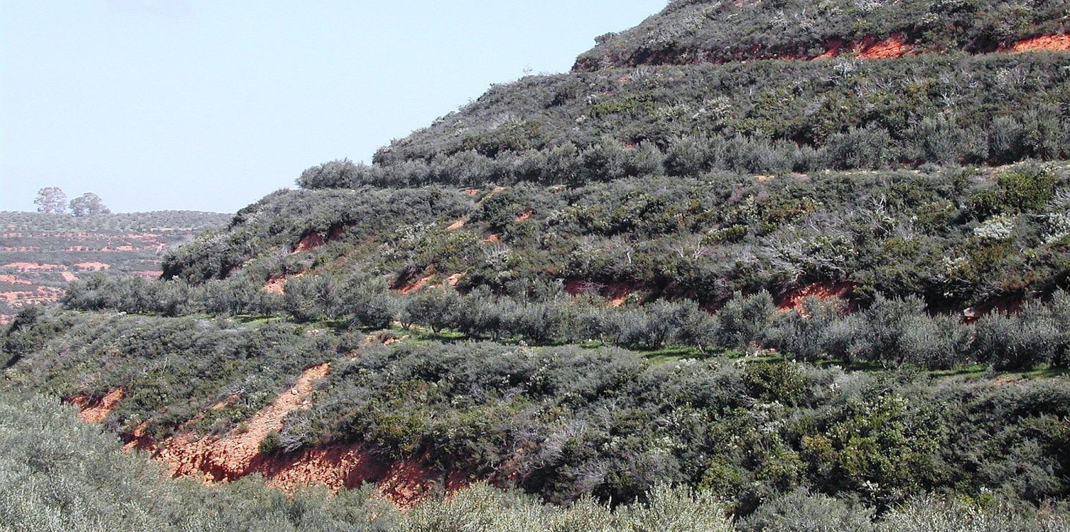
Bench terrace is the main type of terraces existing in the area of Chania. Land terracing is mainly found in the middle and upper zone of the study area and especially in steep slopes and in soils formed mainly in shale or conglomerates parent material. The land in which terraces have been constructed is estimated to 7.7% of the total area of Chania. Some bench terraces have been constructed recently in very steep slopes for cultivating the land.

Local agronomists recommend the construction of terraces as a measure for soil erosion protection in hilly areas.

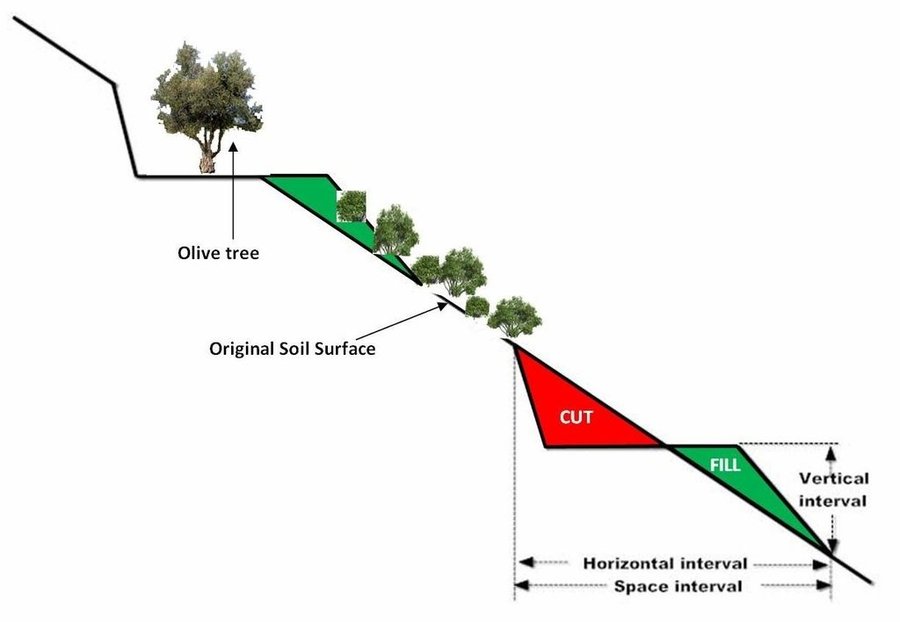
The first step for construction of bench terrace is to clear the field of trash, dead furrows are filled in, and small ridges are levelled. The interval between terraces depends on soil characteristics and amount of rainfall. Usually, it is not recommended space interval narrower than 30 meters. Terrace system design usually begins with a technician evaluating the water regime of the field from observations, soil surveys, and other information. The next decision is whether waterways should follow natural draws or be constructed on new sites. The channel along the terrace for removing excess of runoff water is at least 30 to 45 cm deep and the maximum allowed gradient 0.4% for most soils to avoid serious erosion. Terrace layout begins from the highest point of the field. The vertical fall and slope gradient from the high point to the approximate site of the top terrace, usually 30 to 50 m downslope (depending on gradient), is determined with an engineering level. It is usually preferable to begin staking a terrace at the waterway and work up to the top end. Usually some stakes need to be reset to avoid short, sharp curves and to make field work parallel to the terrace easier. The first layout of a terrace system seldom achieves the most satisfactory design. Some unexpected topographical feature may show up and necessitate changing one or more terrace lines. The final terrace positions should be identified by plough furrows or other implement marks before construction begins. Conventional terraces can be built with bulldozers, motor patrol graders, carryall scrapers, elevating grader terracers, mould-board ploughs, disk tillers with 60 cm or larger disks, and with hand tools and baskets, headpans, or other carrying devices. Terraces rarely should be longer than 600 m. Terraces should not be longer than 375 m on already gullied land. Longer terraces need to be sub¬divided with an outlet provided for each segment. Terraces must be wide enough to accommodate the equipment that will be used in the field, generally not less than 4.5 m. The flatter these slopes are, the easier is to farm but the more expensive they are to build. Trees are usually planted in the upper part of the terrace. In modern terraced fields crop cultivation is fully mechanized. In such terraced fields all farm operations should carried out as nearly as parallel to the terrace as possible to minimize water and soil movement between terraces and to reduce damage to the terrace ridges. The most evident effect of tillage operations, after several years is the increase in the base width of the terrace. The best method of maintaining the shape of the terrace cross section and counteracting erosion from the inter-terraced area is by ploughing with a reversible mouldboard. In steep slopes is recommended to keep the natural vegetation in the part of the steep slope for soil erosion protection.

Lugar

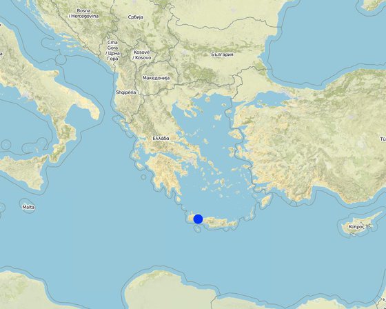
Lugar: Chania-Cete, Selinos province, Grecia

No. de sitios de Tecnología analizados:

Georreferencia de sitios seleccionados
  • 24.1, 35.3333

Difusión de la Tecnología:

¿En un área de protección permanente?:

Fecha de la implementación: hace más de 50 años atrás (tradicional)

Tipo de introducción

Clasificación de la Tecnología

Propósito principal
  • mejorar la producción
  • reducir, prevenir, restaurar la degradación de la tierra
  • conservar el ecosistema
  • proteger una cuenca hidrográfica/ áreas corriente abajo – en combinación con otras Tecnologías
  • preservar/ mejorar biodiversidad
  • reducir el riesgo de desastres naturales
  • adaptarse al cambio climático/ extremos climáticos y sus impactos
  • mitigar cambio climático y sus impactos
  • crear impacto económico benéfico
  • crear impacto social benéfico
Uso de tierra

  • Tierras cultivadas
    • Cosecha de árboles y arbustos: aceituna
    Número de temporadas de cultivo por año: 2

Provisión de agua
  • de secano
  • mixta de secano – irrigada
  • totalmente irrigada

Propósito relacionado a la degradación de las tierras
  • prevenir la degradación de la tierra
  • reducir la degradación de la tierra
  • restaurar/ rehabilitar tierra severamente degradada
  • adaptarse a la degradación de la tierra
  • no aplica
La degradación considerada
  • erosión de suelos por agua - Wt: pérdida de capa arable/ erosión de la superficie
  • degradación del agua - Ha: aridificación
Grupo MST
  • medida de pendiente transversal
Medidas MST
  • medidas estructurales - S1: Terrazas

Dibujo técnico

Especificaciones técnicas
Size of the terrace including bench and sloping part is 35 meters. The original slope with the natural vegetation is 64%. The bench width is 6 meters, the size of the sloping part with natural vegetation is 22 meters, and the length of the bench 145 meters. Olive trees have been planted 2 meters from upper part of the bench.
The vertical interval (VI in meters) between two adjacent terraces can be estimated by the formula given by the U.S. Soil Conservation Service: VI = xS + y. Where x is rainfall factor, S is slope gradient (%), and y is soil and cropping factor. The U.S. Soil conservation Service recommends values for x and y 0.12-0.24, and 0.3-1.2, respectively. The horizontal interval (HI in meters) can be calculated from the equation: HI = (VI/S)*100.
Location: Strovles. Crete
Date: 5/2007

Technical knowledge required for field staff / advisors: moderate (It needs planning of location of various strips and water outlets)
Technical knowledge required for land users: moderate (technical supoport)
Main technical functions: reduction of slope angle, reduction of slope length, increase / maintain water stored in soil
Secondary technical functions: stabilisation of soil (eg by tree roots against land slides)

Terrace: bench level
Spacing between structures (m): 35
Width of ditches/pits/dams (m): 6
Length of ditches/pits/dams (m): 145
Construction material (earth): Displacement of soil for constructing the bench
Slope (which determines the spacing indicated above): 65%
Lateral gradient along the structure: 65%
Author: C. Kosmas

Establecimiento/ mantenimiento: actividades, insumos y costos

Cálculo de insumos y costos
  • Los costos se calculan:
  • Moneda usada para calcular costos: Euro
  • Tasa de cambio (a USD): 1 USD = 1.39 Euro
  • Costo promedio por día del sueldo de la mano de obra contratada: 80.00
Factores más determinantes que afectan los costos
Slope angle, soil depth, parent material
Actividades de establecimiento
  1. Shaping the land using a bulldoze and constructing terraces, cost 1950 euro/ha (Momento/ frequencia: once)
Insumos y costos para establecimiento
Especifique insumo Unidad Cantidad Costos por unidad (Euro) Costos totales por insumo (Euro) % de los costos cubiertos por los usuarios de las tierras
Equipo
machine use ha 1,0 1950,0 1950,0
Costos totales para establecer la Tecnología 1'950.0
Costos totales para establecer la Tecnología en USD 1'402.88
Actividades de mantenimiento
  1. clearing waterways, and checking terraces for collapse, cost 60 euro/ha (Momento/ frequencia: once per year)
Insumos y costos de mantenimiento
Especifique insumo Unidad Cantidad Costos por unidad (Euro) Costos totales por insumo (Euro) % de los costos cubiertos por los usuarios de las tierras
Equipo
machine use ha 1,0 60,0 60,0
Indique los costos totales para mantenecer la Tecnología 60.0
Costos totales para mantener la Tecnología en USD 43.17

Entorno natural

Promedio anual de lluvia
  • < 250 mm
  • 251-500 mm
  • 501-750 mm
  • 751-1,000 mm
  • 1,001-1,500 mm
  • 1,501-2,000 mm
  • 2,001-3,000 mm
  • 3,001-4,000 mm
  • > 4,000 mm
Zona agroclimática
  • húmeda
  • Sub-húmeda
  • semi-árida
  • árida
Especificaciones sobre el clima
670 mm, 6 months dry period
Thermal climate class: tropics, temperate
Pendiente
  • plana (0-2 %)
  • ligera (3-5%)
  • moderada (6-10%)
  • ondulada (11-15%)
  • accidentada (16-30%)
  • empinada (31-60%)
  • muy empinada (>60%)
Formaciones telúricas
  • meseta/ planicies
  • cordilleras
  • laderas montañosas
  • laderas de cerro
  • pies de monte
  • fondo del valle
Altura
  • 0-100 m s.n.m.
  • 101-500 m s.n.m.
  • 501-1,000 m s.n.m
  • 1,001-1,500 m s.n.m
  • 1,501-2,000 m s.n.m
  • 2,001-2,500 m s.n.m
  • 2,501-3,000 m s.n.m
  • 3,001-4,000 m s.n.m
  • > 4,000 m s.n.m
La Tecnología se aplica en
  • situaciones convexas
  • situaciones cóncavas
  • no relevante
Profundidad promedio del suelo
  • muy superficial (0-20 cm)
  • superficial (21-50 cm)
  • moderadamente profunda (51-80 cm)
  • profunda (81-120 cm)
  • muy profunda (>120 cm)
Textura del suelo (capa arable)
  • áspera/ ligera (arenosa)
  • mediana (limosa)
  • fina/ pesada (arcilla)
Textura del suelo (> 20 cm debajo de la superficie)
  • áspera/ ligera (arenosa)
  • mediana (limosa)
  • fina/ pesada (arcilla)
Materia orgánica de capa arable
  • elevada (>3%)
  • media (1-3%)
  • baja (<1%)
Agua subterránea
  • en superficie
  • < 5 m
  • 5-50 m
  • > 50 m
Disponibilidad de aguas superficiales
  • excesiva
  • bueno
  • mediana
  • pobre/ ninguna
Calidad de agua (sin tratar)
  • agua potable de buena calidad
  • agua potable de mala calidad (requiere tratamiento)
  • solo para uso agrícola (irrigación)
  • inutilizable
La calidad de agua se refiere a:
¿La salinidad del agua es un problema?
  • No

Incidencia de inundaciones
  • No
Diversidad de especies
  • elevada
  • mediana
  • baja
Diversidad de hábitats
  • elevada
  • mediana
  • baja

Las características de los usuarios de la tierra que aplican la Tecnología

Orientación del mercado
  • subsistencia (autoprovisionamiento)
  • mixta (subsistencia/ comercial)
  • comercial/ mercado
Ingresos no agrarios
  • menos del 10% de todos los ingresos
  • 10-50% de todo el ingreso
  • > 50% de todo el ingreso
Nivel relativo de riqueza
  • muy pobre
  • pobre
  • promedio
  • rico
  • muy rico
Nivel de mecanización
  • trabajo manual
  • tracción animal
  • mecanizado/motorizado
Sedentario o nómada
  • Sedentario
  • Semi-nómada
  • Nómada
Individuos o grupos
  • individual/ doméstico
  • grupos/ comunal
  • cooperativa
  • empleado (compañía, gobierno)
Género
  • mujeres
  • hombres
Edad
  • niños
  • jóvenes
  • personas de mediana edad
  • ancianos
Área usada por hogar
  • < 0.5 ha
  • 0.5-1 ha
  • 1-2 ha
  • 2-5 ha
  • 5-15 ha
  • 15-50 ha
  • 50-100 ha
  • 100-500 ha
  • 500-1,000 ha
  • 1,000-10,000 ha
  • > 10,000 ha
Escala
  • pequeña escala
  • escala mediana
  • gran escala
Tenencia de tierra
  • estado
  • compañía
  • comunitaria/ aldea
  • grupal
  • individual, sin título
  • individual, con título
Derechos de uso de tierra
  • acceso abierto (no organizado)
  • comunitarios (organizado)
  • arrendamiento
  • individual
Derechos de uso de agua
  • acceso abierto (no organizado)
  • comunitarios (organizado)
  • arrendamiento
  • individual
Acceso a servicios e infraestructura
asistencia técnica

pobre
bueno
mercados

pobre
bueno
caminos y transporte

pobre
bueno
servicios financieros

pobre
bueno

Impacto

Impactos socioeconómicos
Producción de cultivo
disminuyó
incrementó

Cantidad antes de MST: 1200 kg/ha
Cantidad luego de MST: 1500 kg/ha

diversidad de producto
disminuyó
incrementó

manejo de tierras
obstaculizado
simplificado

Cantidad antes de MST: 120 euro/ha
Cantidad luego de MST: 80 euro/ha

ingreso agrario
disminuyó
incrementó

Cantidad antes de MST: 3600 euro/ha
Cantidad luego de MST: 4500 euro/ha

Impactos socioculturales
oportunidades culturales (ej. espirituales, estéticas, otras)
disminuyó
mejoró

oportunidades recreativas
disminuyó
mejoró

mitigación de conflicto
empeoró
mejoró

contribution to human well-being
decreased
increased


increase farmers income and reduction the off site effects

Impactos ecológicos
cantidad de agua
disminuyó
incrementó


15% more water stored into the soil

escurrimiento superficial
incrementó
disminuyó


75% reduction in runoff

humedad del suelo
disminuyó
incrementó


10% increase in soil moisture

pérdida de suelo
incrementó
disminuyó


75% reduction in soil loss

Impactos fuera del sitio
inundaciones río abajo (no deseadas)
incrementó
disminuyó

Análisis costo-beneficio

Beneficios comparados con los costos de establecimiento
Ingresos a corto plazo:
muy negativo
muy positivo

Ingresos a largo plazo
muy negativo
muy positivo

Beneficios comparados con costos de mantenimiento
Ingresos a corto plazo:
muy negativo
muy positivo

Ingresos a largo plazo
muy negativo
muy positivo

Cambio climático

Extremos (desastres) relacionados al clima
tormenta de lluvia local

nada bien
muy bien

Adopción y adaptación

Porcentaje de usuarios de la tierra que adoptaron la Tecnología
  • casos individuales / experimentales
  • 1-10%
  • 11-50%
  • > 50%
De todos quienes adoptaron la Tecnología, ¿cuántos lo hicieron sin recibir incentivos/ pagos materiales?
  • 0-10%
  • 11-50%
  • 51-90%
  • 91-100%
¿La tecnología fue modificada recientemente para adaptarse a las condiciones cambiantes?
  • No
¿A qué condiciones cambiantes?
  • cambios climáticos / extremos
  • mercados cambiantes
  • disponibilidad de mano de obra (ej. debido a migración)

Conclusiones y lecciones aprendidas

Fortalezas: perspectiva del usuario de tierras
  • increase of farmers income from the land exploitation in less favourable areas
Fortalezas: punto de vista del compilador o de otra persona recurso clave
  • Land terracing is one of the soil conservation and cultivation techniques for combating land desertification . It is a practice applied to reduce rainfall runoff on sloping land, from accumulating and causing serious problems of soil erosion. Terraces, usually allow better management of soil and water, improve access to land and facilitate farm operations.
Debilidades/ desventajas/ riesgos: perspectiva del usuario de tierrascómo sobreponerse
  • Planning of land terracing Local institutes and experts to help them
Debilidades/ desventajas/ riesgos: punto de vista del compilador o de otra persona recurso clavecómo sobreponerse
  • Disturbing natural environment and landscapes Better planning

Referencias

Compilador
  • Costas Kosmas
Editors
Revisado por
  • Deborah Niggli
  • Alexandra Gavilano
Fecha de la implementación: 28 de junio de 2011
Últimas actualización: 2 de abril de 2019
Personas de referencia
Descripción completa en la base de datos de WOCAT
Datos MST vinculados
La documentación fue facilitada por
Institución Proyecto
This work is licensed under Creative Commons Attribution-NonCommercial-ShareaAlike 4.0 International