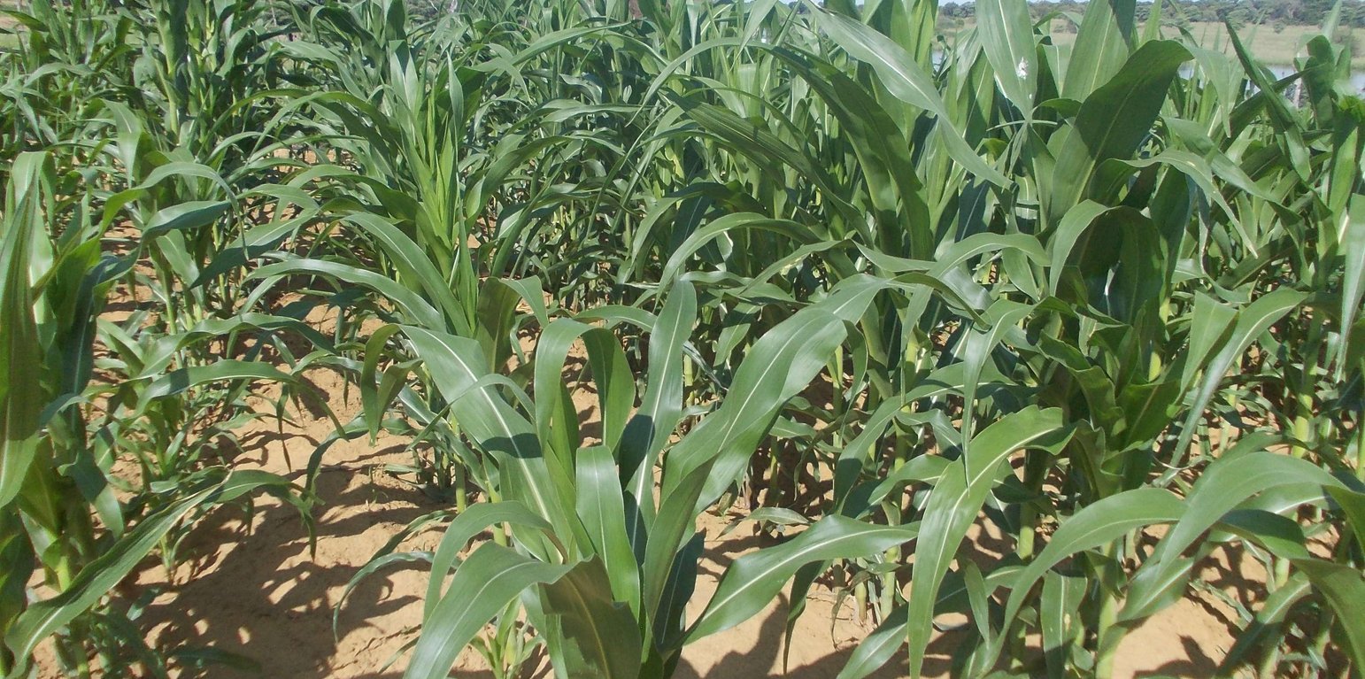
Maize field (Maxon Simfukwe)

Conservation Agriculture in a semi-arid area (Namibia)

Lima nawa (Vambo/Rukwangali)

Descripción

Conservation agriculture using permanent water-harvesting planting basins, or rip-lines and fertilizer/manure application on low fertility dryland soils.

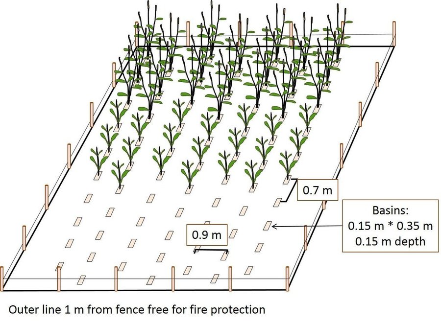
Farmers in north-eastern Namibia practice shifting/semi-permanent subsistence cropping, concentrating on pearl millet cultivation. Here, conservation agriculture (CA) was promoted to sustain and improve production and to reduce conversion of woodland to crops. CA comprises the three principles of minimum soil disturbance, permanent soil cover, and rotation. CA was tested on small plots with volunteers trained by a local NGO. The technology was characterized here by: (i) Early (pre-rains) preparation of the land with two alternative techniques; either: a) basins with a defined spacing opened by a hand hoe, with composted manure added (biochar has also been tested), or b) rip-lines prepared with oxen in lines and with manure application within the rip lines; (ii) Mulching the soil with crop residues, branches or sunnhemp, specially grown for the purpose; (iii) Protection against grazing of crop and mulch by livestock; (iv) Intercropping with vegetables or legumes. (v) Weeding.

CA has been promoted for four seasons, and now trained farmers are transferring their knowledge to others. The technology was promoted to substantially improve the low yields of traditionally practiced agriculture by improving fertility and soil structure as well as better capturing runoff. It was also aimed at avoiding further expansion of croplands into dry woodlands on low fertility arenosols. Eventually it is hoped that the well-being of local subsistence cropping communities will be improved and outmigration reduced.

Knowledge about CA comes from Zambia, where it has been has been practiced successfully for many years by small-scale farmers. A local NGO was engaged by an international project (www.future-okavango.org) which searched for volunteer farmers in the Kavango area. The first CA planting took place in 2011/12. These pioneer farmers were backstopped regularly and the number of farmers trained increased. The NGO monitored crops with contact farmers. 45 more farmers showed interest and were then trained by the contact farmers. Training and backstopping continued until August 2015.

The natural environment is semi-arid. Rainfall is concentrated from November to March. Mean annual precipitation is 570 mm, and mean air temperature is 26.2°C in the hottest month (October) and 16.2°C in the coldest month (July). The landscape forms part of the extended Kalahari basin in central-southern Africa. Deep and extended sands restrict people to living in areas close to surface water. Villages are located along the Okavango on the elevated river terraces – where they produce crops. Here, sedimentation of fine-grained soils, the accumulation of calcium carbonates in the subsoil and the activity of termites have resulted in soils of medium fertility which could potentially ensure yields of 500 kg/ha of millet, if well managed, and assuming good rainfall. Due to the growing population and restricted land availability, cultivation patterns have changed from shifting to semi-permanent and expanded to the adjacent woodlands on the deep Kalahari sands. Here, rapid degradation of soil fertility has caused further expansion and reduced crop yields to very low levels (ca. 150 kg/ha on average). Livestock graze and browse vegetation on the floodplains and in the woodlands. Due to night-time kraaling of livestock, manure is available as fertilizer: thus sustained cropping can be supported. The importance of the woodlands for ecosystem services including timber and firewood, for thatching grass, medicinal plants and biodiversity means they must be conserved and this acts as a reason to support the search for alternative crop production systems such as CA.

Lugar

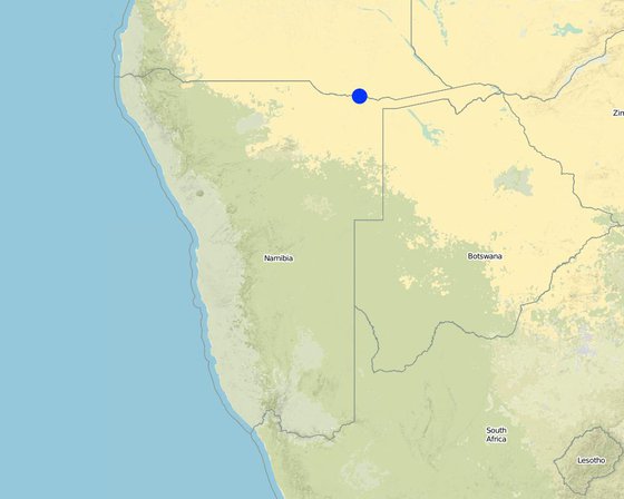
Lugar: Mashare, Kavango East, Namibia

No. de sitios de Tecnología analizados:

Georreferencia de sitios seleccionados
  • 20.16, -17.9

Difusión de la Tecnología: distribuida parejamente sobre un área (approx. < 0.1 km2 (10 ha))

¿En un área de protección permanente?:

Fecha de la implementación: hace menos de 10 años (recientemente)

Tipo de introducción
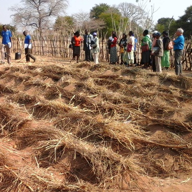
Demostration plot: Basins prepared and mulch distributed (Maxon Simfukwe)

Clasificación de la Tecnología

Propósito principal
  • mejorar la producción
  • reducir, prevenir, restaurar la degradación de la tierra
  • conservar el ecosistema
  • proteger una cuenca hidrográfica/ áreas corriente abajo – en combinación con otras Tecnologías
  • preservar/ mejorar biodiversidad
  • reducir el riesgo de desastres naturales
  • adaptarse al cambio climático/ extremos climáticos y sus impactos
  • mitigar cambio climático y sus impactos
  • crear impacto económico benéfico
  • crear impacto social benéfico
Uso de tierra
Mezcla de tipos de uso de tierras dentro de la misma unidad de tierras: Sí - Agropastoralismo (incluyendo cultivo-ganado integrados)

  • Tierras cultivadas
    • Cosecha anual
    Número de temporadas de cultivo por año: 1
  • Tierra de pastoreo
    • Pastoralismo semi-nómada
Provisión de agua
  • de secano
  • mixta de secano – irrigada
  • totalmente irrigada

Propósito relacionado a la degradación de las tierras
  • prevenir la degradación de la tierra
  • reducir la degradación de la tierra
  • restaurar/ rehabilitar tierra severamente degradada
  • adaptarse a la degradación de la tierra
  • no aplica
La degradación considerada
  • deterioro químico del suelo - Cn: reducción de la fertilidad y contenido reducido de la materia orgánica del suelo (no ocasionados por la erosión)
  • degradación biológica - Bc: reducción de la cobertura vegetal del suelo , Bf: efectos nocivos de los fuegos, Bl: pérdida de la vida del suelo
Grupo MST
  • manejo integrado de la fertilidad del suelo
  • medida de pendiente transversal
  • cosecha de agua
Medidas MST
  • medidas agronómicas - A3: Tratamiento de superficie del suelo
  • medidas de manejo - M2: Cambio de gestión/ nivel de intensidad

Dibujo técnico

Especificaciones técnicas
Scheme of CA field with basins
Within the fenced area, basins are dug per hand-hoe in lines with about 15 cm width, 35 cm length and 15 cm depth and in 70 cm distance. To keep the line and position, a rope with knots every 70 cm is used. Each basin is refilled with 2 cans of manure mixed with part of the soil material. Maize or pearl millet - two stages shown on the graph
Location: Mashare. Kavano East/Namibia

Technical knowledge required for field staff / advisors: moderate
Technical knowledge required for land users: low
Main technical functions: increase in nutrient availability (supply, recycling,…)
Secondary technical functions: increase / maintain water stored in soil, increase of biomass (quantity)

Early planting
Remarks: Planting basins prepared in dry season, planting can occur by first rainfalls (earlier than plough-d

Mixed cropping / intercropping
Material/ species: Maize / Millet /Cowpea
Remarks: Cultivated in parallel lines

Mulching
Material/ species: Grasses & crop residues & sunhemp
Remarks: sunhemp cultivated on the CA field and cut to produce mulch

Green manure
Material/ species: branches of fertilizer tree

Manure / compost / residues
Material/ species: Composted manure from cattle post

Rotations / fallows
Material/ species: Maize / Millet /Cowpea
Remarks: Planted in lines and shifted annually

Minimum tillage
Material/ species: Riplines by oxen

Pits
Material/ species: planting basins by hand hoe

Retention/infiltration ditch/pit, sediment/sand trap
Spacing between structures (m): 0.7
Depth of ditches/pits/dams (m): 0.15
Width of ditches/pits/dams (m): 0.15
Length of ditches/pits/dams (m): 0.35

Structural measure: ripline
Spacing between structures (m): 0.7
Depth of ditches/pits/dams (m): 0.25
Width of ditches/pits/dams (m): 0.1

For water harvesting: the ratio between the area where the harvested water is applied and the total area from which water is collected is: 1:8,3
Change of land use practices / intensity level: More specific soil management; crop protection by fencing; earlier seeding
Major change in timing of activities: To a large part, land preparation can be carried out throughout dry season, independent of rainfall level
Author: Maxon Simfukwe

Establecimiento/ mantenimiento: actividades, insumos y costos

Cálculo de insumos y costos
  • Los costos se calculan:
  • Moneda usada para calcular costos: Nam $
  • Tasa de cambio (a USD): 1 USD = 15.5 Nam $
  • Costo promedio por día del sueldo de la mano de obra contratada: n.d.
Factores más determinantes que afectan los costos
CA was designed to require minimal financial investments; theoretically, everything apart from wire for the fences and inorganic fertilizer can be created or gather by the household. This turns CA into a very labour intensive farming practice. The high Dollar values above result from multiplying the (free) family labour invested in farming with the typical hourly wage rate of an external worker
Actividades de establecimiento
  1. (Momento/ frequencia: dry season)
Insumos y costos para establecimiento
Especifique insumo Unidad Cantidad Costos por unidad (Nam $) Costos totales por insumo (Nam $) % de los costos cubiertos por los usuarios de las tierras
Mano de obra
labour ha 1,0 1104,0 1104,0 100,0
Material de construcción
Wire for fencing ha 1,0 224,0 224,0 100,0
sticks & poles ha 1,0 1114,0 1114,0 100,0
Costos totales para establecer la Tecnología 2'442.0
Costos totales para establecer la Tecnología en USD 157.55
Actividades de mantenimiento
  1. Repairing fences and de-bushing of the fields (Momento/ frequencia: (May - July))
  2. Gatering and spreading of mulch cover (Momento/ frequencia: July - Dec)
  3. Cutting sunhemp and applying as additional mulch (Momento/ frequencia: Feb-Mar)
  4. Re-digging the planting basins (Momento/ frequencia: August)
  5. Manure collection, Planting & fertilizer application (Momento/ frequencia: September - December)
  6. Sowing of main crops and sunnhemp and fertilizer application (Momento/ frequencia: November - December)
  7. Intercropping with legumes like groundnuts and cowpeas normally two weeks after germination of cereals. (Momento/ frequencia: None)
  8. Weeding (Momento/ frequencia: None)
  9. Harvesting (Momento/ frequencia: April - May)
Insumos y costos de mantenimiento
Especifique insumo Unidad Cantidad Costos por unidad (Nam $) Costos totales por insumo (Nam $) % de los costos cubiertos por los usuarios de las tierras
Mano de obra
labour ha 1,0 848,0 848,0 100,0
Material para plantas
seeds ha 1,0 22,0 22,0 100,0
Fertilizantes y biocidas
fertilizer ha 1,0 159,0 159,0 100,0
compost/manure ha 1,0 276,0 276,0 100,0
Material de construcción
Wire for fencing ha 1,0 220,0 220,0 100,0
Indique los costos totales para mantenecer la Tecnología 1'525.0
Costos totales para mantener la Tecnología en USD 98.39

Entorno natural

Promedio anual de lluvia
  • < 250 mm
  • 251-500 mm
  • 501-750 mm
  • 751-1,000 mm
  • 1,001-1,500 mm
  • 1,501-2,000 mm
  • 2,001-3,000 mm
  • 3,001-4,000 mm
  • > 4,000 mm
Zona agroclimática
  • húmeda
  • Sub-húmeda
  • semi-árida
  • árida
Especificaciones sobre el clima
Thermal climate class: subtropics
Pendiente
  • plana (0-2 %)
  • ligera (3-5%)
  • moderada (6-10%)
  • ondulada (11-15%)
  • accidentada (16-30%)
  • empinada (31-60%)
  • muy empinada (>60%)
Formaciones telúricas
  • meseta/ planicies
  • cordilleras
  • laderas montañosas
  • laderas de cerro
  • pies de monte
  • fondo del valle
Altura
  • 0-100 m s.n.m.
  • 101-500 m s.n.m.
  • 501-1,000 m s.n.m
  • 1,001-1,500 m s.n.m
  • 1,501-2,000 m s.n.m
  • 2,001-2,500 m s.n.m
  • 2,501-3,000 m s.n.m
  • 3,001-4,000 m s.n.m
  • > 4,000 m s.n.m
La Tecnología se aplica en
  • situaciones convexas
  • situaciones cóncavas
  • no relevante
Profundidad promedio del suelo
  • muy superficial (0-20 cm)
  • superficial (21-50 cm)
  • moderadamente profunda (51-80 cm)
  • profunda (81-120 cm)
  • muy profunda (>120 cm)
Textura del suelo (capa arable)
  • áspera/ ligera (arenosa)
  • mediana (limosa)
  • fina/ pesada (arcilla)
Textura del suelo (> 20 cm debajo de la superficie)
  • áspera/ ligera (arenosa)
  • mediana (limosa)
  • fina/ pesada (arcilla)
Materia orgánica de capa arable
  • elevada (>3%)
  • media (1-3%)
  • baja (<1%)
Agua subterránea
  • en superficie
  • < 5 m
  • 5-50 m
  • > 50 m
Disponibilidad de aguas superficiales
  • excesiva
  • bueno
  • mediana
  • pobre/ ninguna
Calidad de agua (sin tratar)
  • agua potable de buena calidad
  • agua potable de mala calidad (requiere tratamiento)
  • solo para uso agrícola (irrigación)
  • inutilizable
La calidad de agua se refiere a:
¿La salinidad del agua es un problema?
  • No

Incidencia de inundaciones
  • No
Diversidad de especies
  • elevada
  • mediana
  • baja
Diversidad de hábitats
  • elevada
  • mediana
  • baja

Las características de los usuarios de la tierra que aplican la Tecnología

Orientación del mercado
  • subsistencia (autoprovisionamiento)
  • mixta (subsistencia/ comercial)
  • comercial/ mercado
Ingresos no agrarios
  • menos del 10% de todos los ingresos
  • 10-50% de todo el ingreso
  • > 50% de todo el ingreso
Nivel relativo de riqueza
  • muy pobre
  • pobre
  • promedio
  • rico
  • muy rico
Nivel de mecanización
  • trabajo manual
  • tracción animal
  • mecanizado/motorizado
Sedentario o nómada
  • Sedentario
  • Semi-nómada
  • Nómada
Individuos o grupos
  • individual/ doméstico
  • grupos/ comunal
  • cooperativa
  • empleado (compañía, gobierno)
Género
  • mujeres
  • hombres
Edad
  • niños
  • jóvenes
  • personas de mediana edad
  • ancianos
Área usada por hogar
  • < 0.5 ha
  • 0.5-1 ha
  • 1-2 ha
  • 2-5 ha
  • 5-15 ha
  • 15-50 ha
  • 50-100 ha
  • 100-500 ha
  • 500-1,000 ha
  • 1,000-10,000 ha
  • > 10,000 ha
Escala
  • pequeña escala
  • escala mediana
  • gran escala
Tenencia de tierra
  • estado
  • compañía
  • comunitaria/ aldea
  • grupal
  • individual, sin título
  • individual, con título
Derechos de uso de tierra
  • acceso abierto (no organizado)
  • comunitarios (organizado)
  • arrendamiento
  • individual
Derechos de uso de agua
  • acceso abierto (no organizado)
  • comunitarios (organizado)
  • arrendamiento
  • individual
Acceso a servicios e infraestructura
salud

pobre
x
bueno
educación

pobre
x
bueno
asistencia técnica

pobre
x
bueno
empleo (ej. fuera de la granja)

pobre
x
bueno
mercados

pobre
x
bueno
energía

pobre
x
bueno
caminos y transporte

pobre
x
bueno
agua potable y saneamiento

pobre
x
bueno
servicios financieros

pobre
x
bueno

Impacto

Impactos socioeconómicos
Producción de cultivo
disminuyó
x
incrementó

gastos en insumos agrícolas
incrementó
x
disminuyó


not measured but assumed

ingreso agrario
disminuyó
x
incrementó

carga de trabajo
incrementó
x
disminuyó


not measured but assumed

Impactos socioculturales
seguridad alimentaria/ autosuficiencia
disminuyó
x
mejoró

situación de salud
empeoró
x
mejoró

oportunidades culturales (ej. espirituales, estéticas, otras)
disminuyó
x
mejoró

oportunidades recreativas
disminuyó
x
mejoró

mitigación de conflicto
empeoró
x
mejoró


Envy and gossip were observed

situación de grupos en desventaja social y económica (género, etáreo, estatus, etnicidad, etc.)
empeoró
x
mejoró

contribution to human well-being
decreased
x
increased


Improved and stabilized yields help rural families to adapt to modern lifestyles. However, the long-term contribution of CA to the well-being of the local farmers cannot be foreseen. The establishment of family-owned fenced areas for crop production is likely to have an influence on the social structure of the rural communities.

Impactos ecológicos
evaporación
incrementó
x
disminuyó


not measured but assumed

humedad del suelo
disminuyó
x
incrementó


not measured but assumed

cubierta del suelo
disminuyó
x
mejoró


not measured but assumed

ciclo/ recarga de nutrientes
disminuyó
x
incrementó


not measured but assumed

materia orgánica debajo del suelo C
disminuyó
x
incrementó


not measured but assumed

Impactos fuera del sitio

Análisis costo-beneficio

Beneficios comparados con los costos de establecimiento
Ingresos a corto plazo:
muy negativo
x
muy positivo

Ingresos a largo plazo
muy negativo
x
muy positivo

Beneficios comparados con costos de mantenimiento
Ingresos a corto plazo:
muy negativo
x
muy positivo

Ingresos a largo plazo
muy negativo
x
muy positivo

Cambio climático

Extremos (desastres) relacionados al clima
sequía

nada bien
x
muy bien

Adopción y adaptación

Porcentaje de usuarios de la tierra que adoptaron la Tecnología
  • casos individuales / experimentales
  • 1-10%
  • 11-50%
  • > 50%
De todos quienes adoptaron la Tecnología, ¿cuántos lo hicieron sin recibir incentivos/ pagos materiales?
  • 0-10%
  • 11-50%
  • 51-90%
  • 91-100%
¿La tecnología fue modificada recientemente para adaptarse a las condiciones cambiantes?
  • No
¿A qué condiciones cambiantes?
  • cambios climáticos / extremos
  • mercados cambiantes
  • disponibilidad de mano de obra (ej. debido a migración)

Conclusiones y lecciones aprendidas

Fortalezas: perspectiva del usuario de tierras
  • Saves labour over time
  • Can use less land compared to conventional system for the same harvest/yield
Fortalezas: punto de vista del compilador o de otra persona recurso clave
  • A strength of the system is the timely land preparation
  • The advantage of permanent planting stations results from the higher availability of nutrients to crop roots.
  • The moisture retention within the rooting space is improved by the surface structure and the increase in soil organic matter
  • The rotations of crop rotations is encouraged
  • All inputs can be used precicely, there is less wastage of inputs
Debilidades/ desventajas/ riesgos: perspectiva del usuario de tierrascómo sobreponerse
  • The weed management is labour intensive and the impact of pests might be a future challange. The application of more mulch and the weeding regularly in the first part of the season is supposed to reduce weeds.
Debilidades/ desventajas/ riesgos: punto de vista del compilador o de otra persona recurso clavecómo sobreponerse
  • To start with this technology is labour intensive at the beginning. In this moment, the hard pan caused by years of ploughing has to be loosened. Because the basins/riplines are permanently maintained in CA, the preceding land preparations become easier. Also since land preparation starts before on-set of rains, one can spread labour by starting just after harvesting crop
  • There is a general problem of constructing fences around fields in communal lands, as state authorities declare this land as being owned by the state. By agreeing with the local leadership to allow those doing CA to fence off their fields for proper keeping of residues and basins/riplines that might be prone to free livestock grazing after crop harvests.

Referencias

Compilador
  • Alexander Groengroeft
Editors
Revisado por
  • Deborah Niggli
  • David Streiff
  • Alexandra Gavilano
Fecha de la implementación: 17 de marzo de 2016
Últimas actualización: 31 de mayo de 2019
Personas de referencia
Descripción completa en la base de datos de WOCAT
Datos MST vinculados
La documentación fue facilitada por
Institución Proyecto
Referencias claves
  • Groengroeft, A., et al. (2013) A method for yield assessment on rainfeld dryland agricultural fields.: Biodiversity & Ecology 5:279 - 286
  • Kowalski, B. et al. (2013) Mashare - The People.: Biodiversity & Ecology 5:121-128
  • Pröpper, M. et al. (2010) Causes and perspectives of land-cover change through expanding cultivation in Kavango.: Biodiversity in southern Africa. Volume 3: Implications for landuse and management, eds. M. T. Hoffman, U. Schmiedel and N. Jürgens. Göttingen & Windhoek: Klaus Hess Publishers.
  • Pröpper, M. et al. (2015) The Future Okavango – Findings, Scenarios and Recommendations for Action.: Research Project Final Synthesis Report 2010-2015, 190. Windhoek: University of Hamburg
This work is licensed under Creative Commons Attribution-NonCommercial-ShareaAlike 4.0 International