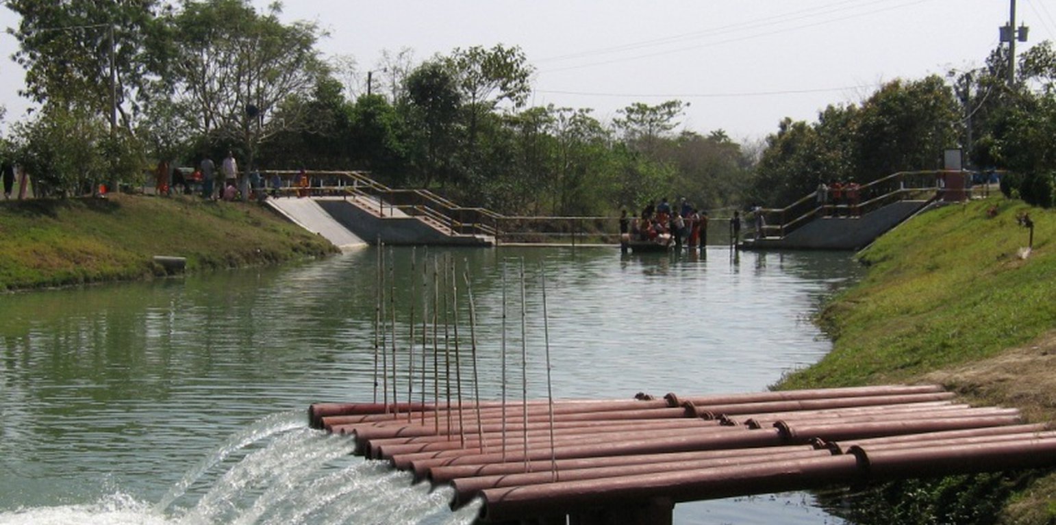
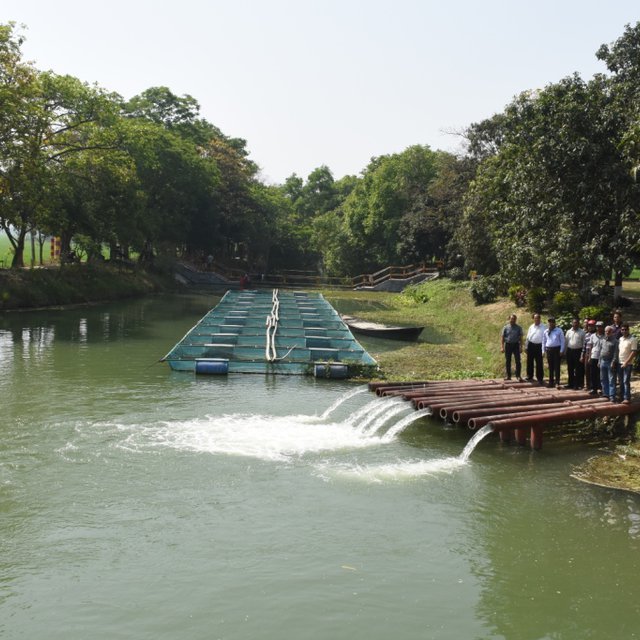
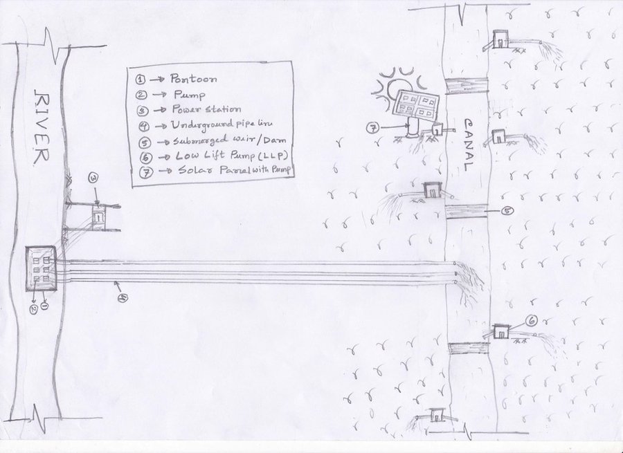
Water from the Padma river lifted to the Sharmangla canal for irrigation (Zillul Bari)

Mainstreaming river water to facilitate irrigation in Barind (Bangladesh)

Sharmongla Sech Prokolpo.

Descripción

The technology promotes the lifting of river water by pump sets and conveys the water through buried pipelines to a canal. The conserved canal water is used for irrigation delivered by low lift pumps (LLP). Because water is held in the canal it revitalises the ecosystem along its length. Furthermore, using river water for irrigation avoids dangers associated with groundwater depletion.

The project is sited at Sharmongla under Godagari Upazilla of Rajshahi district. The Sharmongla canal is located about 3.5 km away from the Padma river. Its total length is 29.0 km. Under this technology, water is lifted from the Padma river by pumps set on a pontoon. The lifted water is then discharged to a canal through underground pipelines. The water so discharged is lifted to the crop fields (delivery points) for irrigation. The elevation difference between the delivery points and the sourcing river is about 21 m. There are numbers of submerged weirs/dams constructed across the canal at different locations for conserving water: the water then helps regenerate the ecosystem along its banks and enriches the habitat.
Pontoon at a glance:
•Year of construction: 2004
•No. of centrifugal pumps at pontoon: 12
•Pump capacity: 50 m lifting height.
•Power of each pump: 60 HP
•Capacity of each pump: 2.5 cusec
•Total capacity of pump sets: 30 cusec
•Capacity of electric sub-station: 750 KW
•No. of discharge pipelines: 12

Sharmongla canal at a glance:
•Length of the canal: 29 km
•Average width of the canal: 15 m
•Average depth from ground level: 5 m
•No. of submerged weirs and dams within the canal: 14
•No. of LLP (low lift pump): 27 electrified and 6 solar pumps
•Total irrigated area: 1850 ha
•Benefiting farmers: 5330
•Harvest yield of rice per year: 20,500 metric tonnes (approx.)
•Afforestation on the canal bank: 65,500 trees

Purposes/objectives of the technology:
•The main purpose of the said technology is to provide water for irrigation. This prevents abstracting of groundwater, which has adverse effects on the environment: therefore this system is environment friendly.
• Enhancing groundwater recharge thereby supports ecosystem function.
•The storing of river water in irrigation canals supports the enrichment of the habitat.

Approach for implementing the technology:
There was no irrigation facility for crop production in this drought-prone area. Government officials came to the locality, discussed with the local community, elites, as well as the farmers. Finally, the local community was convinced about the technology. Then the irrigation system could be implemented in the area. On seeing the success of the technology, the same has been replicated on approx. 9400 ha. in Barind area, benefitting approx. 32,200 farmers.

Maintenance of the technology:
In case of problems, the respective mechanic of that area informs the Assistant Engineer through the Sub-Assistant Engineer. Thus the problem is solved by their own initiative. It is also monitored by the Executive Engineer of the respective District, and finally by the Executive Director from the headquarters if needed.

Crop cultivation:
Due to the application of the technology, previously fallow land has come under cultivation/irrigation facilities, mono-cropped land has been converted into multi-cropped land. Different crops, like rice, wheat, maize, mustard, pulses, potato, tomato, spices and other vegetables are cultivated.

Farmers’ acceptance:
The technology has been well accepted by the farmers, as uncultivated land has been brought under cultivation and different crops are now being cultivated year-round.

Lugar

Lugar: Bangladesh

No. de sitios de Tecnología analizados: 2-10 sitios

Georreferencia de sitios seleccionados
  • 88.34248, 24.48567

Difusión de la Tecnología: aplicada en puntos específicos/ concentrada en un área pequeña

¿En un área de protección permanente?: No

Fecha de la implementación: 10-50 años atrás

Tipo de introducción
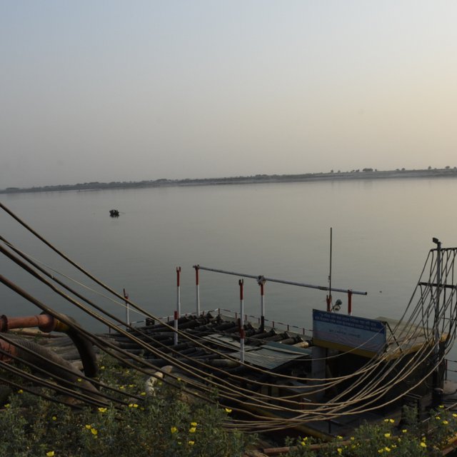
Pontoon with pumps at Padma river; there are 12 pumps operating (Zillul Bari)
Water in the Sharmangla river (Zillul Bari)

Clasificación de la Tecnología

Propósito principal
  • mejorar la producción
  • reducir, prevenir, restaurar la degradación de la tierra
  • conservar el ecosistema
  • proteger una cuenca hidrográfica/ áreas corriente abajo – en combinación con otras Tecnologías
  • preservar/ mejorar biodiversidad
  • reducir el riesgo de desastres naturales
  • adaptarse al cambio climático/ extremos climáticos y sus impactos
  • mitigar cambio climático y sus impactos
  • crear impacto económico benéfico
  • crear impacto social benéfico
Uso de tierra
Mezcla de tipos de uso de tierras dentro de la misma unidad de tierras: Sí - Agroforestería

  • Tierras cultivadas
    • Cosecha anual
    • Cosecha de árboles y arbustos: mango, mangostán, guayaba
    Número de temporadas de cultivo por año: 3
    ¿Se practica el intercultivo? Sí
    ¿Se practica la rotación de cultivos? Sí

Provisión de agua
  • de secano
  • mixta de secano – irrigada
  • totalmente irrigada

Propósito relacionado a la degradación de las tierras
  • prevenir la degradación de la tierra
  • reducir la degradación de la tierra
  • restaurar/ rehabilitar tierra severamente degradada
  • adaptarse a la degradación de la tierra
  • no aplica
La degradación considerada
  • degradación del agua - Ha: aridificación, Hq: reducción de la calidad de aguas subterráneas
Grupo MST
  • agroforestería
  • Manejo de irrigación: (incl. provisión de agua, invernaderos)
  • manejo de agua superficial (manantial, río, lagos, mar):
Medidas MST
  • medidas estructurales - S3: Acequias graduadas, canales, vías fluviales, S5: Diques, hondonadas, estanques, S7: Equipo para cosechar agua / provisión de agua/ irrigación, S10: Medidas de ahorro de energía
  • medidas de manejo - M2: Cambio de gestión/ nivel de intensidad , M3: disposición de acuerdo al entorno natural y humano

Dibujo técnico

Especificaciones técnicas
1. Pontoon: Length 55 ft, Width: 25 ft, Height: 4.50 ft
2. Centrifugal pump (12 nos)—each pump 60 HP,capacity-2.5 cusec, pump head: 50m
3. Electric power station capacity: 750 KW
4. Underground water distribution line (12 nos): Length of each line is 3.50 km
5. Length of water storage canal (Sharmangla canal): 29.0 km (average width 15.0 m and depth 5.0 m)
6. Nos of submerged weir/dam to reserve water in the canal: 14 nos
7. Nos of LLP (electrified) to lift water from the canal to crop field through buried pipeline : 27 nos
8. Nos of solar pump to lift water from the canal to crop field through buried pipeline: 06 nos
9. Nos of Prepaid meter for collecting irrigation charges (Revenue): 33 nos
10. Irrigated area: 1850 ha
11. Construction materials:
-Pontoon: A kind of platform that float on water made of Mild steel sheet, Stainless steel etc.
- Power station: Transformer, electric pole, wire etc.
- Distribution line: mild steel and PVC pipe
- Dam/Submerged weir: steel bar, cement, sand, brick, stone etc.
Author: Sayed Zillul Bari

Establecimiento/ mantenimiento: actividades, insumos y costos

Cálculo de insumos y costos
  • Los costos se calculan: por unidad de Tecnología (unidad: 1 Pontoon, Pumps, Pipes, weir construction etc volume, length: Pontoon (Length 55 ft, Width: 25 ft, Height: 4.50 ft) is a platform build on iron sheets, that can float on river, where pumps were set. The pipes for water delivery were of PVC. Water canal in this case compiler referred to canals of Barind which were ephemeral. Now water reserve for year round use.Piping system includes PVC pipe to convey water to the field, where a valve was set to control water disposal. There is a pipe of 12 inch dia to maintain water head through out the system.)
  • Moneda usada para calcular costos: BDT
  • Tasa de cambio (a USD): 1 USD = 85.0 BDT
  • Costo promedio por día del sueldo de la mano de obra contratada: 800 BDT
Factores más determinantes que afectan los costos
Pontoon construction, power supply and lining of the underground piping system.
Actividades de establecimiento
  1. Pontoon construction and installation on the river (Momento/ frequencia: 60 days)
  2. Pumps installation on the pontoon (Momento/ frequencia: 30 days)
  3. Construction of underground water distribution line (Momento/ frequencia: 70 days)
  4. Re-excavation of derelict canal (Momento/ frequencia: 120 days)
  5. Construction of submerged weir / dam (Momento/ frequencia: 180 days)
  6. LLP installation at the canal bank (27 nos) (Momento/ frequencia: 150 days)
  7. Solar pump installation (06 nos) (Momento/ frequencia: 45 days)
  8. Pre-paid meter installation at pump sites to collect irrigation charges (33 nos) (Momento/ frequencia: 30 days)
  9. Buried pipe line construction for irrigation at crop land sites (Momento/ frequencia: 120 days)
Insumos y costos para establecimiento (per 1 Pontoon, Pumps, Pipes, weir construction etc)
Especifique insumo Unidad Cantidad Costos por unidad (BDT) Costos totales por insumo (BDT) % de los costos cubiertos por los usuarios de las tierras
Material de construcción
Pontoon construction and installation on the river 1 1,0 5000000,0 5000000,0
Construction of underground water distribution line 1 1,0 27800000,0 27800000,0
Construction of submerged weir / dam 1 14,0 1600000,0 22400000,0
Re-excavation of derelict canal 1 1,0 29000000,0 29000000,0
Otros
Pre-paid meter installation at pump sites to collect irrigation charges 1 33,0 243000,0 8019000,0
Solar pump installation 1 6,0 2000000,0 12000000,0
LLP installation at the canal bank (27 nos) 1 8,0 2700000,0 21600000,0
Pumps installation on the pontoon 1 12,0 1833000,0 21996000,0
Buried pipe line construction for irrigation at crop land sites 1 1,0 23100000,0 23100000,0
Costos totales para establecer la Tecnología 170'915'000.0
Costos totales para establecer la Tecnología en USD 2'010'764.71
Actividades de mantenimiento
  1. Pontoon repair and maintenance (Momento/ frequencia: 1/5years)
  2. Pump repair and maintenance (Momento/ frequencia: As per requirement, 1/yr)
  3. Distribution line maintenance (Momento/ frequencia: As per requirement, 1/yr)
  4. Power station repair and maintenance (Momento/ frequencia: As per requirement, 1/yr)
  5. Submerged weir / dam repair and maintenance (Momento/ frequencia: 1/5yrs)
  6. LLP repair and maintenance (Momento/ frequencia: 2/yr or as and when necessary)
  7. Buried pipe line repair and maintenance (Momento/ frequencia: 1/6yrs, as and when necessary)
  8. Prepaid meter repair (Momento/ frequencia: 2-3/yr)
Insumos y costos de mantenimiento (per 1 Pontoon, Pumps, Pipes, weir construction etc)
Especifique insumo Unidad Cantidad Costos por unidad (BDT) Costos totales por insumo (BDT) % de los costos cubiertos por los usuarios de las tierras
Equipo
Prepaid meter repair 1 0,2 100000,0 20000,0
Material de construcción
Buried pipe line repair and maintenance 1 1,0 0,05 0,05
Otros
Pontoon repair and maintenance 1 1,0 500000,0 500000,0
Pump repair and maintenance (each) 1 1,0 20000,0 20000,0
Distribution line maintenance 1 1,0 75000,0 75000,0
Power station repair and maintenance 1 1,0 50000,0 50000,0
Submerged weir / dam repair and maintenance (each) 1 1,0 200000,0 200000,0
LLP repair and maintenance (each) 1 1,0 50000,0 50000,0
Indique los costos totales para mantenecer la Tecnología 915'000.05
Costos totales para mantener la Tecnología en USD 10'764.71

Entorno natural

Promedio anual de lluvia
  • < 250 mm
  • 251-500 mm
  • 501-750 mm
  • 751-1,000 mm
  • 1,001-1,500 mm
  • 1,501-2,000 mm
  • 2,001-3,000 mm
  • 3,001-4,000 mm
  • > 4,000 mm
Zona agroclimática
  • húmeda
  • Sub-húmeda
  • semi-árida
  • árida
Especificaciones sobre el clima
Promedio anual de lluvia en mm:1600.0
Most of the rainfall events happen during May to October
Nombre de la estación meteorológica: Agroecological region 26
Pendiente
  • plana (0-2 %)
  • ligera (3-5%)
  • moderada (6-10%)
  • ondulada (11-15%)
  • accidentada (16-30%)
  • empinada (31-60%)
  • muy empinada (>60%)
Formaciones telúricas
  • meseta/ planicies
  • cordilleras
  • laderas montañosas
  • laderas de cerro
  • pies de monte
  • fondo del valle
Altura
  • 0-100 m s.n.m.
  • 101-500 m s.n.m.
  • 501-1,000 m s.n.m
  • 1,001-1,500 m s.n.m
  • 1,501-2,000 m s.n.m
  • 2,001-2,500 m s.n.m
  • 2,501-3,000 m s.n.m
  • 3,001-4,000 m s.n.m
  • > 4,000 m s.n.m
La Tecnología se aplica en
  • situaciones convexas
  • situaciones cóncavas
  • no relevante
Profundidad promedio del suelo
  • muy superficial (0-20 cm)
  • superficial (21-50 cm)
  • moderadamente profunda (51-80 cm)
  • profunda (81-120 cm)
  • muy profunda (>120 cm)
Textura del suelo (capa arable)
  • áspera/ ligera (arenosa)
  • mediana (limosa)
  • fina/ pesada (arcilla)
Textura del suelo (> 20 cm debajo de la superficie)
  • áspera/ ligera (arenosa)
  • mediana (limosa)
  • fina/ pesada (arcilla)
Materia orgánica de capa arable
  • elevada (>3%)
  • media (1-3%)
  • baja (<1%)
Agua subterránea
  • en superficie
  • < 5 m
  • 5-50 m
  • > 50 m
Disponibilidad de aguas superficiales
  • excesiva
  • bueno
  • mediana
  • pobre/ ninguna
Calidad de agua (sin tratar)
  • agua potable de buena calidad
  • agua potable de mala calidad (requiere tratamiento)
  • solo para uso agrícola (irrigación)
  • inutilizable
La calidad de agua se refiere a: agua subterránea y superficial
¿La salinidad del agua es un problema?
  • No

Incidencia de inundaciones
  • No
Diversidad de especies
  • elevada
  • mediana
  • baja
Diversidad de hábitats
  • elevada
  • mediana
  • baja

Las características de los usuarios de la tierra que aplican la Tecnología

Orientación del mercado
  • subsistencia (autoprovisionamiento)
  • mixta (subsistencia/ comercial)
  • comercial/ mercado
Ingresos no agrarios
  • menos del 10% de todos los ingresos
  • 10-50% de todo el ingreso
  • > 50% de todo el ingreso
Nivel relativo de riqueza
  • muy pobre
  • pobre
  • promedio
  • rico
  • muy rico
Nivel de mecanización
  • trabajo manual
  • tracción animal
  • mecanizado/motorizado
Sedentario o nómada
  • Sedentario
  • Semi-nómada
  • Nómada
Individuos o grupos
  • individual/ doméstico
  • grupos/ comunal
  • cooperativa
  • empleado (compañía, gobierno)
Género
  • mujeres
  • hombres
Edad
  • niños
  • jóvenes
  • personas de mediana edad
  • ancianos
Área usada por hogar
  • < 0.5 ha
  • 0.5-1 ha
  • 1-2 ha
  • 2-5 ha
  • 5-15 ha
  • 15-50 ha
  • 50-100 ha
  • 100-500 ha
  • 500-1,000 ha
  • 1,000-10,000 ha
  • > 10,000 ha
Escala
  • pequeña escala
  • escala mediana
  • gran escala
Tenencia de tierra
  • estado
  • compañía
  • comunitaria/ aldea
  • grupal
  • individual, sin título
  • individual, con título
Derechos de uso de tierra
  • acceso abierto (no organizado)
  • comunitarios (organizado)
  • arrendamiento
  • individual
Derechos de uso de agua
  • acceso abierto (no organizado)
  • comunitarios (organizado)
  • arrendamiento
  • individual
Acceso a servicios e infraestructura
salud

pobre
bueno
educación

pobre
bueno
asistencia técnica

pobre
bueno
empleo (ej. fuera de la granja)

pobre
bueno
mercados

pobre
bueno
energía

pobre
bueno
caminos y transporte

pobre
bueno
agua potable y saneamiento

pobre
bueno
servicios financieros

pobre
bueno

Impacto

Impactos socioeconómicos
Producción de cultivo
disminuyó
incrementó

calidad de cultivo
disminuyó
incrementó

producción de forraje
disminuyó
incrementó

calidad de forraje
disminuyó
incrementó

producción animal
disminuyó
incrementó

riesgo de fracaso de producción
incrementó
disminuyó

diversidad de producto
disminuyó
incrementó

área de producción (nuevas tierras bajo cultivo/ en uso)
disminuyó
incrementó

manejo de tierras
obstaculizado
simplificado

disponibilidad de agua potable
disminuyó
incrementó

calidad de agua potable
disminuyó
incrementó

disponibilidad de agua para ganado
disminuyó
incrementó

calidad de agua para ganado
disminuyó
incrementó

disponibilidad de agua para irrigar
disminuyó
incrementó

calidad de agua para irrigar
disminuyó
incrementó

demanda de agua para irrigar
incrementó
disminuyó


At present land users are used to grow high water demanding crops. For example Boro paddy and potato both crops require large volume of water and the irrigated area slowly increasing, that situation demand of irrigation water increasing.

gastos en insumos agrícolas
incrementó
disminuyó


The supply of agricultural inputs increased and channelized through deploying dealers etc. Hence expenses relatively decreased

ingreso agrario
disminuyó
incrementó

diversidad de fuentes de ingreso
disminuyó
incrementó

disparidades económicas
incrementó
disminuyó


Basically in this area could be grouped in to two. One group has almost no land and previously they have to migrate beyond barind area as labor and they were poor. At present they have job (agri-labor or otherwise) in their area and become more solvent then past 90's. On other hand the second group cultivate the land of their own or leased, which they could not in 90's. They also in handicap because of poor crop and no option to cultivate in two seasons. Hence apparently both groups as of their status are in well shape. The peoples those who have no land for cultivation now can engage them in many other entrepreneurship (e.g. farm product marketing, livestock/poultry raring, carpentering, grocery, etc etc) emerged.

carga de trabajo
incrementó
disminuyó

Impactos socioculturales
seguridad alimentaria/ autosuficiencia
disminuyó
mejoró

situación de salud
empeoró
mejoró

derechos de uso de la tierra/ agua
empeoró
mejoró

oportunidades culturales (ej. espirituales, estéticas, otras)
disminuyó
mejoró

oportunidades recreativas
disminuyó
mejoró

instituciones comunitarias
se debilitaron
se fortalecieron

instituciones nacionales
se debilitaron
se fortalecieron


Along with the Barind Multipurpose Development Authority (BMDA) other national institutions like Department of Agricultural Extension, Livestock, Fisheries, Bangladesh Rural Development Board (BRDB), Financial institutions- Rajshahi Agricultural Development Bank and others (NGO) are operating more effectively in the Barind in multiple dimensions. In addition students from Rajshahi University also engaged in their research on various issues. BMDA also improving its capacity and skill to develop more effective approach for Barind area.

MST/ conocimiento de la degradación de la tierra
disminuyó
mejoró

mitigación de conflicto
empeoró
mejoró

Impactos ecológicos
cantidad de agua
disminuyó
incrementó

calidad de agua
disminuyó
incrementó

cosecha/recolección de agua (escurrimiento, rocío, nieve, etc.)
disminuyó
mejoró

escurrimiento superficial
incrementó
disminuyó


This comment was done comparing between conveying water by open drainage and through pipeline. Definitely there are almost no run-off from pipe line distribution. On the hand land users have to confirm their field bunds to protect run-off. Prepaid metering system also restricted land users not to allow excess water to over flow from their field. In-spite of that there may be small amount run-off, but the detachment of top soils is within tolerable limit and accumulate within field bunds.

drenaje de agua en exceso
disminuyó
mejoró

nivel freático/ acuífero
disminuyó
recargó


It is reported that ground water slowly recharged, As a results shallow tube wells are also working , which were about to abandoned before.

evaporación
incrementó
disminuyó


Vegetation coverage increased,

cubierta del suelo
disminuyó
mejoró


Increased land cover-Reduced drought

pérdida de suelo
incrementó
disminuyó


In 90's the lands were bare and in monsoon after heavy downpour a large amount of water going to downstream as run-off with detached top soil. At present land is covered, field bunds are strengthen, restrict run-off as a result soil loss decreased.

acumulación de suelo
disminuyó
incrementó


Field bunds enhance soil accumulation by limiting run-off water by field bunds/dykes.

compactación de suelo
incrementó
disminuyó


Mechanized cultivation and usage of farm machinery however enhance soil compaction.

impactos de sequías
incrementó
disminuyó

emisión de carbono y gases de invernadero
incrementó
disminuyó


Emission of carbon decreased as vegetation cover round the year increased.

micro-clima
empeoró
mejoró


Reduced dusty wind, temperature cooler then before.

The Barind was almost desert like before 90's. Its natural vegetation were almost extinct. Biodiversity both Species and habitat were low. At present it is improving spectacularly.
None
None

Impactos fuera del sitio
disponibilidad de agua (aguas subterráneas, manantiales)
disminuyó
incrementó


Usage of surface water reduces groundwater abstraction and improves groundwater (GW) recharge

contaminación de aguas subterráneas/ de ríos
incrementó
disminuyó


As the land cover has increased, that has a substantial impact on limiting polluted surface water to flow up to river.

Análisis costo-beneficio

Beneficios comparados con los costos de establecimiento
Ingresos a corto plazo:
muy negativo
muy positivo

Ingresos a largo plazo
muy negativo
muy positivo

Beneficios comparados con costos de mantenimiento
Ingresos a corto plazo:
muy negativo
muy positivo

Ingresos a largo plazo
muy negativo
muy positivo

Cambio climático

Cambio climático gradual
temperatura anual disminuyó

nada bien
muy bien
temperatura estacional disminuyó

nada bien
muy bien
Estación: verano
lluvia anual incrementó

nada bien
muy bien
lluvia estacional incrementó

nada bien
muy bien
Estación: verano Respuesta: no se sabe

Adopción y adaptación

Porcentaje de usuarios de la tierra que adoptaron la Tecnología
  • casos individuales / experimentales
  • 1-10%
  • 11-50%
  • > 50%
De todos quienes adoptaron la Tecnología, ¿cuántos lo hicieron sin recibir incentivos/ pagos materiales?
  • 0-10%
  • 11-50%
  • 51-90%
  • 91-100%
Número de hogares y/ o área cubierta
It could rather to explain as the beneficiaries of the technology. Truly a single land user or a group of land user will not able to install this type of system for multiple reasons. There are two components of this technology, one is the government institution who provided the scope of using surface water for irrigation and the second one are the land user who use the scope or facilities of irrigation system Here about 1800 farmers are involved to use surface water as their irrigation source.
¿La tecnología fue modificada recientemente para adaptarse a las condiciones cambiantes?
  • No
¿A qué condiciones cambiantes?
  • cambios climáticos / extremos
  • mercados cambiantes
  • disponibilidad de mano de obra (ej. debido a migración)
where there are no canal for water storage , local ponds are used to reserve the surface water to irrigate land surrounding the pods and obviously where river water could not be reached.

Conclusiones y lecciones aprendidas

Fortalezas: perspectiva del usuario de tierras
  • Ensured crop production through irrigation
  • Reduced ground water irrigation and decrease ground water depletion.
  • Increased work facility at project area
Fortalezas: punto de vista del compilador o de otra persona recurso clave
  • Improved socio-economic condition of beneficiaries
  • Increased ground water recharge
  • Increased fish cultivation and duck farming at the canal
Debilidades/ desventajas/ riesgos: perspectiva del usuario de tierrascómo sobreponerse
  • Scope of individual level implementation is very limited Community approach will facilitate the SLM implementation etc.
  • Maintenance, distribution and regulation of water etc have no control of the beneficiaries Capacity of the beneficiaries to be developed
Debilidades/ desventajas/ riesgos: punto de vista del compilador o de otra persona recurso clavecómo sobreponerse
  • Source of lifting water points may be shifted in the long run Efficiencies of irrigation water supply need more attention with demand and supply.
  • Weak linkage with beneficiaries Integrated approach needed to include community and implementing agencies.
  • Crops with high water demand may not sustain in the long run Appropriate crop and cropping patterns are to be adopted with crop zoning
  • Increasing cropping intensity leads to deficiency of soil nutrients Monitoring of soil health essential for this region.

Referencias

Compilador
  • Jalal Uddin Md. Shoaib
Editors
Revisado por
  • Udo Höggel
  • William Critchley
  • Rima Mekdaschi Studer
Fecha de la implementación: 27 de junio de 2019
Últimas actualización: 19 de diciembre de 2022
Personas de referencia
Descripción completa en la base de datos de WOCAT
Datos MST vinculados
La documentación fue facilitada por
Institución Proyecto
Referencias claves
  • Project documents: Available in BMDA
Vínculos a la información relevante disponible en línea
This work is licensed under Creative Commons Attribution-NonCommercial-ShareaAlike 4.0 International