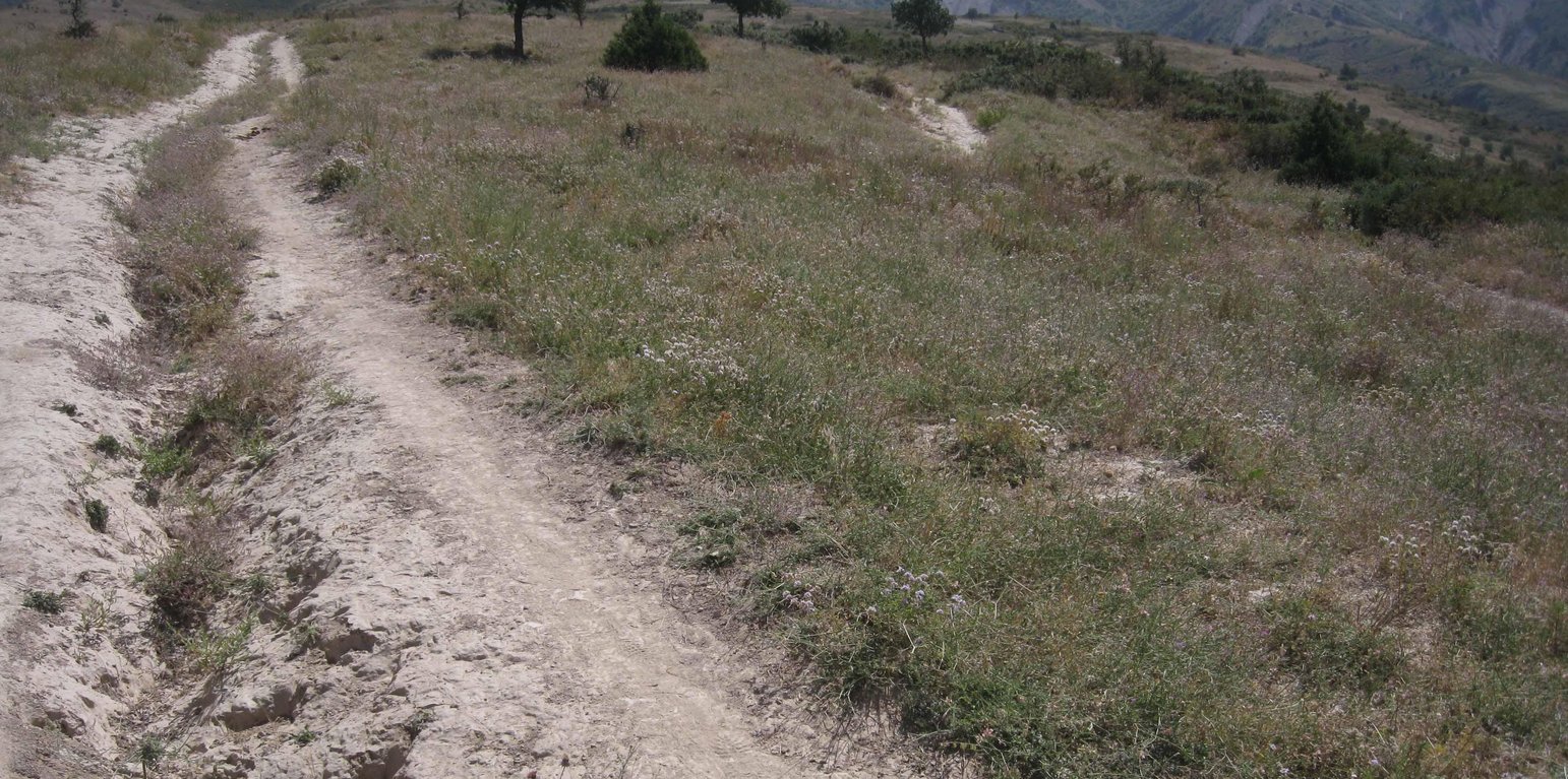
Eroded path through the pastureland (Malgorzata Conder)

Pasture management of a communal grazing land (Tayikistán)

Descripción

Pasture management of a communal land through daily rotation

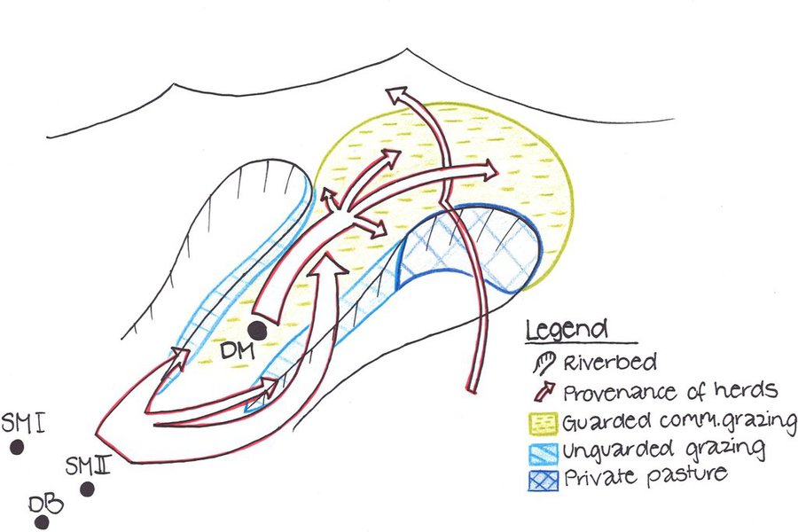
The total area of the pasture accounts for 300 – 500 ha. The pasture is property of the Doshmand village but it includes also some private properties, mainly potato and wheat crops. After the harvest, livestock is also grazing on these crops. Eighteen households are currently using the pasture with a total of 150 cows and 500 small animals. Additionally, three groups of herds from other villages graze irregularly on this pasture mainly on the lateral parts as it is less guarded by the villagers. The interviewee estimates that over 1000 cows, goats and sheep are coming from other villages. Other herds cross this pasture when migrating to or coming back from the summer pasture in spring and autumn, respectively. Nevertheless Doshmand residents claim that this intrusive grazing is accepted as “every animal has to be fed”. This shows the need of a pasture management not only on village but also on watershed level.
During Soviet time the inhabitants of Doshmand were forced to migrate to the valley. In 2003, the resettlement of the ancient location started with two families. Simultaneously, the pasture management was established and joined by each family who resettled. The controlled area is divided in 4 subparts. The herd switches daily within them. Every household looks after the herd for a day, which results in a rotational cycle of 18 days. There are no fixed and regular meetings for pasture management within the village pasture. However, two subsequent herders communicate to know where the herd has been grazing and where to graze the next time.

Purpose of the Technology: Purpose of the rotational grazing is to graze on one subpart, while the three other areas are resting. This reduces the impact of grazed and trampled areas per subpart and allows the growth and recovery of the vegetation in the other parts.
The task of herding is shared among the families. The rotational grazing is organized orally and freely, why it’s not sure if that approach is strictly binding. Discussions about pasture management rise only in case of need.

Establishment / maintenance activities and inputs: Doshmand village got the pasture in a good condition at the time of establishment. Vegetation cover was high. The only investment consisted in building a water point for the livestock. A further investment was to buy a water pipe and dig out a channel for the pipe to conduct the water from the water point to the village. Money was collected by the families and many villagers were involved in digging the channel.
No further input was and is required except coordination between the herders.

Natural / human environment: The pasture of Doshmand village is located in the middle and upper zone of the watershed. Thanks to the distance to other settlements, the pasture is less affected by overgrazing than other communal pastures in the watershed. Nevertheless, the pasture is heterogeneously grazed, with some areas which are difficult to access even for livestock and hence abundant vegetation. Other areas, especially those situated next to the village show a more bare vegetation cover.

Lugar

Lugar: Muminabad, Khatlon, Tajikistan, Tayikistán

No. de sitios de Tecnología analizados:

Georreferencia de sitios seleccionados
  • 70.04219, 38.01485

Difusión de la Tecnología: distribuida parejamente sobre un área (approx. 1-10 km2)

¿En un área de protección permanente?:

Fecha de la implementación: 10-50 años atrás

Tipo de introducción
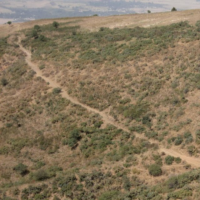
Heterogenous vegetation cover within the watershed (Malgorzata Conder)

Clasificación de la Tecnología

Propósito principal
  • mejorar la producción
  • reducir, prevenir, restaurar la degradación de la tierra
  • conservar el ecosistema
  • proteger una cuenca hidrográfica/ áreas corriente abajo – en combinación con otras Tecnologías
  • preservar/ mejorar biodiversidad
  • reducir el riesgo de desastres naturales
  • adaptarse al cambio climático/ extremos climáticos y sus impactos
  • mitigar cambio climático y sus impactos
  • crear impacto económico benéfico
  • crear impacto social benéfico
Uso de tierra

  • Tierras cultivadas
    • Cosecha anual: cereales - trigo (verano), cereales - trigo (invierno), cultivos de raíces/ tubérculos - patatas
    Número de temporadas de cultivo por año: 1
  • Tierra de pastoreo
    • Pastoralismo semi-nómada
    • rotational grazing

Provisión de agua
  • de secano
  • mixta de secano – irrigada
  • totalmente irrigada

Propósito relacionado a la degradación de las tierras
  • prevenir la degradación de la tierra
  • reducir la degradación de la tierra
  • restaurar/ rehabilitar tierra severamente degradada
  • adaptarse a la degradación de la tierra
  • no aplica
La degradación considerada
  • erosión de suelos por agua - Wo: efectos de degradación fuera del sitio
  • deterioro químico del suelo - Cn: reducción de la fertilidad y contenido reducido de la materia orgánica del suelo (no ocasionados por la erosión)
  • deterioro físico del suelo - Pc: compactación
  • degradación biológica - Bc: reducción de la cobertura vegetal del suelo , Bs: reducción en la calidad y composición/ diversidad de las especies
Grupo MST
  • pastoralismo y manejo de tierras de pastoreo
Medidas MST
  • medidas de manejo - M2: Cambio de gestión/ nivel de intensidad

Dibujo técnico

Especificaciones técnicas
Livestock from Doshmand village (DM) is grazing in the four subparts of the communal pasture. Livestock from other villages, located in the valley Sarmadoni I (SMI) and II (SMII) and Dehibaland (DB), can invade the guarded and unguarded communal pasture of Doschmand. In spring and autumn also other livestock crosses Doshmand's pasture when migrating to or leaving the summer pasture.

Location: Chukurak watershed. Muminabad, Khatlon

Technical knowledge required for land users: low

Main technical functions: improvement of ground cover, increase of infiltration

Secondary technical functions: improvement of topsoil structure (compaction), stabilisation of soil (eg by tree roots against land slides), increase in organic matter

Change of land use practices / intensity level: Rotational grazing at village level
Author: Malgorzata Conder

Establecimiento/ mantenimiento: actividades, insumos y costos

Cálculo de insumos y costos
  • Los costos se calculan:
  • Moneda usada para calcular costos: USD
  • Tasa de cambio (a USD): 1 USD = n.d.
  • Costo promedio por día del sueldo de la mano de obra contratada: 12.40
Factores más determinantes que afectan los costos
There are no costly factors, the most important input is a good planning, coordination and consistent execution of the rotational grazing system. The installation of a waterpoint would be needed but it is a very costly installation.
Actividades de establecimiento
  1. Coordination with villagers and herders (Momento/ frequencia: Reestablishment of village)
Insumos y costos para establecimiento
Especifique insumo Unidad Cantidad Costos por unidad (USD) Costos totales por insumo (USD) % de los costos cubiertos por los usuarios de las tierras
Mano de obra
Coordination with villagers and herders - 1,0
Actividades de mantenimiento
  1. Consultation with village herders (Momento/ frequencia: If needed)
Insumos y costos de mantenimiento
Especifique insumo Unidad Cantidad Costos por unidad (USD) Costos totales por insumo (USD) % de los costos cubiertos por los usuarios de las tierras
Mano de obra
Consultation with village herders - 1,0

Entorno natural

Promedio anual de lluvia
  • < 250 mm
  • 251-500 mm
  • 501-750 mm
  • 751-1,000 mm
  • 1,001-1,500 mm
  • 1,501-2,000 mm
  • 2,001-3,000 mm
  • 3,001-4,000 mm
  • > 4,000 mm
Zona agroclimática
  • húmeda
  • Sub-húmeda
  • semi-árida
  • árida
Especificaciones sobre el clima
Annual rainfall (1,001-1,500 mm): Totally 800mm: 700mm in winter-spring, July-Sept dry season (At 1200mm asl, weather station Muminabad)

Annual rainfall (1,501-2,000 mm): Precipitation increases 60mm per 100m of altitude in average. Here up to 1600mm.
Thermal climate class: temperate

LPG from April until September
Pendiente
  • plana (0-2 %)
  • ligera (3-5%)
  • moderada (6-10%)
  • ondulada (11-15%)
  • accidentada (16-30%)
  • empinada (31-60%)
  • muy empinada (>60%)
Formaciones telúricas
  • meseta/ planicies
  • cordilleras
  • laderas montañosas
  • laderas de cerro
  • pies de monte
  • fondo del valle
Altura
  • 0-100 m s.n.m.
  • 101-500 m s.n.m.
  • 501-1,000 m s.n.m
  • 1,001-1,500 m s.n.m
  • 1,501-2,000 m s.n.m
  • 2,001-2,500 m s.n.m
  • 2,501-3,000 m s.n.m
  • 3,001-4,000 m s.n.m
  • > 4,000 m s.n.m
La Tecnología se aplica en
  • situaciones convexas
  • situaciones cóncavas
  • no relevante
Profundidad promedio del suelo
  • muy superficial (0-20 cm)
  • superficial (21-50 cm)
  • moderadamente profunda (51-80 cm)
  • profunda (81-120 cm)
  • muy profunda (>120 cm)
Textura del suelo (capa arable)
  • áspera/ ligera (arenosa)
  • mediana (limosa)
  • fina/ pesada (arcilla)
Textura del suelo (> 20 cm debajo de la superficie)
  • áspera/ ligera (arenosa)
  • mediana (limosa)
  • fina/ pesada (arcilla)
Materia orgánica de capa arable
  • elevada (>3%)
  • media (1-3%)
  • baja (<1%)
Agua subterránea
  • en superficie
  • < 5 m
  • 5-50 m
  • > 50 m
Disponibilidad de aguas superficiales
  • excesiva
  • bueno
  • mediana
  • pobre/ ninguna
Calidad de agua (sin tratar)
  • agua potable de buena calidad
  • agua potable de mala calidad (requiere tratamiento)
  • solo para uso agrícola (irrigación)
  • inutilizable
La calidad de agua se refiere a:
¿La salinidad del agua es un problema?
  • No

Incidencia de inundaciones
  • No
Diversidad de especies
  • elevada
  • mediana
  • baja
Diversidad de hábitats
  • elevada
  • mediana
  • baja

Las características de los usuarios de la tierra que aplican la Tecnología

Orientación del mercado
  • subsistencia (autoprovisionamiento)
  • mixta (subsistencia/ comercial)
  • comercial/ mercado
Ingresos no agrarios
  • menos del 10% de todos los ingresos
  • 10-50% de todo el ingreso
  • > 50% de todo el ingreso
Nivel relativo de riqueza
  • muy pobre
  • pobre
  • promedio
  • rico
  • muy rico
Nivel de mecanización
  • trabajo manual
  • tracción animal
  • mecanizado/motorizado
Sedentario o nómada
  • Sedentario
  • Semi-nómada
  • Nómada
Individuos o grupos
  • individual/ doméstico
  • grupos/ comunal
  • cooperativa
  • empleado (compañía, gobierno)
Género
  • mujeres
  • hombres
Edad
  • niños
  • jóvenes
  • personas de mediana edad
  • ancianos
Área usada por hogar
  • < 0.5 ha
  • 0.5-1 ha
  • 1-2 ha
  • 2-5 ha
  • 5-15 ha
  • 15-50 ha
  • 50-100 ha
  • 100-500 ha
  • 500-1,000 ha
  • 1,000-10,000 ha
  • > 10,000 ha
Escala
  • pequeña escala
  • escala mediana
  • gran escala
Tenencia de tierra
  • estado
  • compañía
  • comunitaria/ aldea
  • grupal
  • individual, sin título
  • individual, con título
Derechos de uso de tierra
  • acceso abierto (no organizado)
  • comunitarios (organizado)
  • arrendamiento
  • individual
Derechos de uso de agua
  • acceso abierto (no organizado)
  • comunitarios (organizado)
  • arrendamiento
  • individual
Acceso a servicios e infraestructura
salud

pobre
bueno
educación

pobre
bueno
asistencia técnica

pobre
bueno
empleo (ej. fuera de la granja)

pobre
bueno
mercados

pobre
bueno
energía

pobre
bueno
caminos y transporte

pobre
bueno
agua potable y saneamiento

pobre
bueno
servicios financieros

pobre
bueno

Impacto

Impactos socioeconómicos
producción de forraje
disminuyó
incrementó

producción animal
disminuyó
incrementó


Not the whole pastureland can be grazed at once

disponibilidad de agua para ganado
disminuyó
incrementó

calidad de agua para ganado
disminuyó
incrementó

Impactos socioculturales
seguridad alimentaria/ autosuficiencia
disminuyó
mejoró

instituciones comunitarias
se debilitaron
se fortalecieron

Livelihoods and human well-being
reduced
improved


Strenghtening of the community sense and awareness through increased coordination for rotational grazing between villagers. Higher fodder availability leads to healthier livestock.

Impactos ecológicos
escurrimiento superficial
incrementó
disminuyó

evaporación
incrementó
disminuyó

humedad del suelo
disminuyó
incrementó

encostramiento/ sellado de suelo
incrementó
disminuyó

compactación de suelo
incrementó
disminuyó

biomasa/ sobre suelo C
disminuyó
incrementó

riesgo de incendio
incrementó
disminuyó

Hazards towards adverse events
improved
reduced

Impactos fuera del sitio
colmatación río abajo
incrementó
disminuyó

capacidad de amortiguación/ filtrado (por suelo, vegetación, humedales)
disminuyó
mejoró

daños a infraestructura pública / privada
incrementó
disminuyó

Análisis costo-beneficio

Beneficios comparados con los costos de establecimiento
Ingresos a corto plazo:
muy negativo
muy positivo

Ingresos a largo plazo
muy negativo
muy positivo

Beneficios comparados con costos de mantenimiento
Ingresos a corto plazo:
muy negativo
muy positivo

Ingresos a largo plazo
muy negativo
muy positivo

Cambio climático

Cambio climático gradual
temperatura anual incrementó

nada bien
muy bien
Extremos (desastres) relacionados al clima
tormenta de lluvia local

nada bien
muy bien
tormenta de viento

nada bien
muy bien
sequía

nada bien
muy bien
inundación general (río)

nada bien
muy bien
Otras consecuencias relacionadas al clima
periodo reducido de crecimiento

nada bien
muy bien
Respuesta: no se sabe

Adopción y adaptación

Porcentaje de usuarios de la tierra que adoptaron la Tecnología
  • casos individuales / experimentales
  • 1-10%
  • 11-50%
  • > 50%
De todos quienes adoptaron la Tecnología, ¿cuántos lo hicieron sin recibir incentivos/ pagos materiales?
  • 0-10%
  • 11-50%
  • 51-90%
  • 91-100%
Número de hogares y/ o área cubierta
NA
¿La tecnología fue modificada recientemente para adaptarse a las condiciones cambiantes?
  • No
¿A qué condiciones cambiantes?
  • cambios climáticos / extremos
  • mercados cambiantes
  • disponibilidad de mano de obra (ej. debido a migración)

Conclusiones y lecciones aprendidas

Fortalezas: perspectiva del usuario de tierras
  • No big input, coordination between farmers exists anyway
Fortalezas: punto de vista del compilador o de otra persona recurso clave
  • In a rotational grazing system at village level every family is responsible for the sustainability of the pasture

    How can they be sustained / enhanced? Give more responsability and co-determination to individuals
  • High establishment potential as rotational grazing do not demand any costs, except coordination and organization on village level

    How can they be sustained / enhanced? Disseminate the idea of rotational grazing also on watershed level
  • Ecologic benefits as high vegetation cover, less erosion etc. can be achieved without monetary investment

    How can they be sustained / enhanced? Spread knowledge of long-term effects by rotational grazing
  • Being a pasture of a big area extent in the uphills, the good quality of the pasture plays an important role for all the settlements and cultivations downstream

    How can they be sustained / enhanced? Raise the awareness about the upstream-downstream interrelation in the watersheds
Debilidades/ desventajas/ riesgos: perspectiva del usuario de tierrascómo sobreponerse
Debilidades/ desventajas/ riesgos: punto de vista del compilador o de otra persona recurso clavecómo sobreponerse
  • In reality, rotational grazing is not executed strictly enough Stricter separation of the subparts needed
  • Herds from other villages graze in the same pasture Strenghten coordination of grazing between and within villages
  • Some flanks show high vegetation because they are not accessible for livestock and not because of the rotational grazing

Referencias

Compilador
  • Malgorzata Conder
Editors
Revisado por
  • David Streiff
  • Alexandra Gavilano
Fecha de la implementación: 15 de enero de 2013
Últimas actualización: 6 de agosto de 2019
Personas de referencia
Descripción completa en la base de datos de WOCAT
Datos MST vinculados
La documentación fue facilitada por
Institución Proyecto
This work is licensed under Creative Commons Attribution-NonCommercial-ShareaAlike 4.0 International