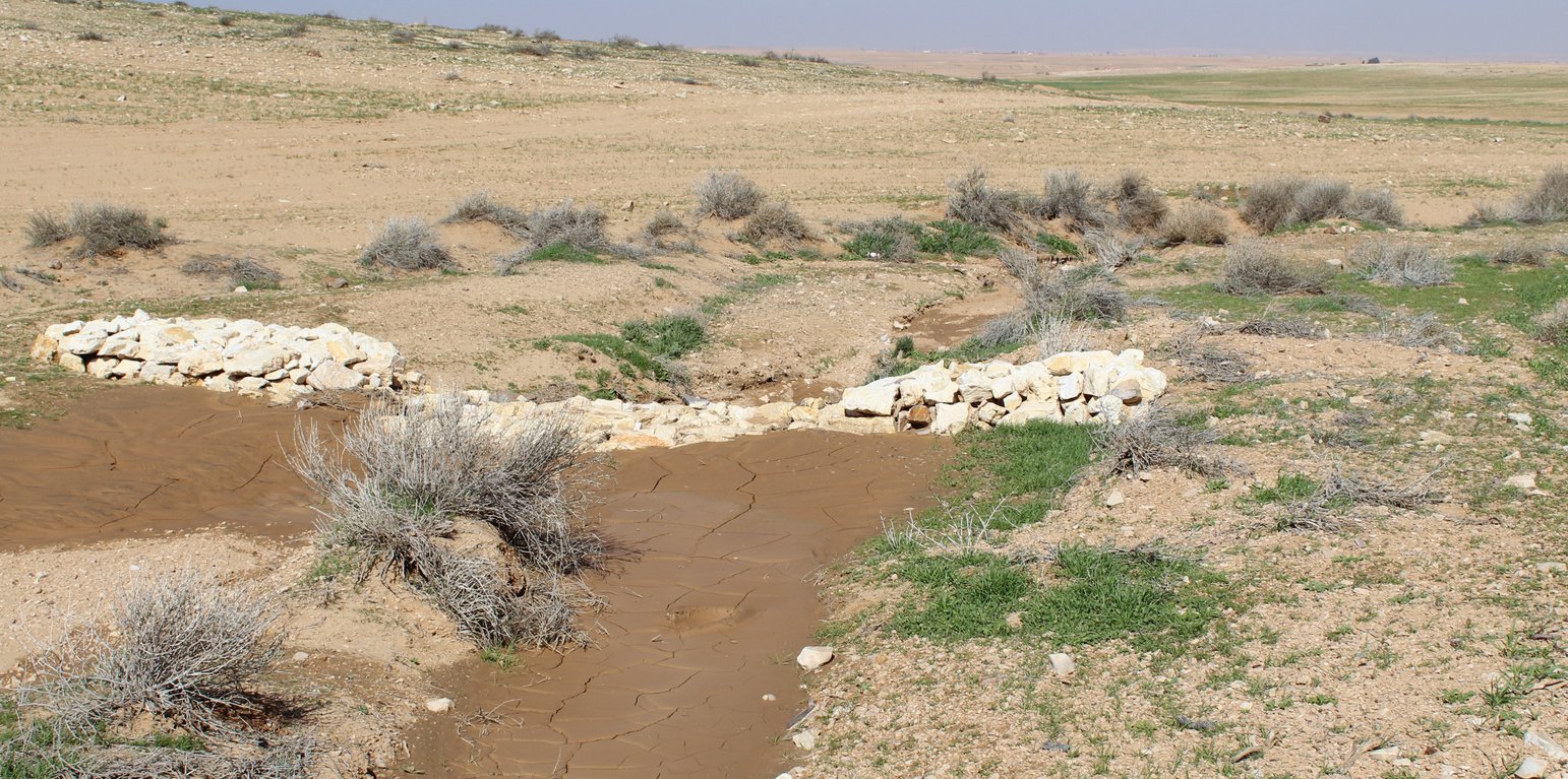
Gully plug (Mira Haddad)

Gully plug (Jordania)

السدات

Descripción

Gully plugs aim at rehabilitating active gullies in dryland watersheds, which are prone to erosion through concentrated surface runoff. Multiple gullies plugged in succession dissipate runoff energy, foster local water retention and infiltration, encourage sedimentation, assist in the stabilization of gully bed and side banks, and stimulate revegetation of flow paths; the channel measures must be combined with proper SLM in the catchments upstream.

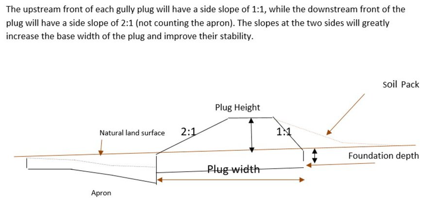
Characteristics: Multiple gully plugs positioned sequentially within a gully system interrupt concentrated surface runoff and reduce its erosive power. The plugs are each made of multiple cobbles/stones mostly ranging between 10 and 30 cm diameter and constructed to ensure a stable structure. The plugs started at the head of the gully (upstream) and ranges from 1.5 - 3.7 m in width with an average of 2.5 m. For heavily eroded and very unstable sections, gabions can be used also. The structures are around 1.0 to 1.5-m high, anchored into the sidewalls, and around 0.20 to 0.35 m deep into the gully bed, built up to around 1/3 to max. 1/2 of the gully depth - ensuring the concentrated flow stays within the channel and does not overflow the side banks. The top of the plug is U-shaped, with the sides built higher than the centre. Upslope, the plugs are packed with soil to trap sediments (stopping it flowing through the structure), and downslope the plugs have an apron to dissipate the energy of overflowing water, into a micro stilling basin. The downslope side of the gully plug is sloped rather than vertical. The large stones add roughness to the slope, creating a rough spillway that dissipates erosive energy. In the direction of gully flow, several gully plugs are placed such that the upper gully apron is set at approximately the height of the following downstream gully crest.

Environment: The technology is used in a watershed close to Al Majeddyeh village, located in the Middle Badia zone, approximately 30 km south-east of Amman. The climate is arid and warm (Palmer, 2013). The average annual rainfall is around 130 mm. The natural environment is labelled as steppe, “BSh” in the köppen classification. The human environment is characterized by agropastoralists. They are semi-nomadic and live in villages around the watershed, for example, Al Majeddyeh village.

Purpose: The measure interrupts the concentrated flow, reduces velocity, and dissipates energy. Multiple structures along the gully decrease the erosive power of runoff, retaining a fraction of the runoff, inducing sedimentation (upstream of the plug), thus protecting the gully bed from further deep-scouring, and strengthening the gully side banks, especially when this is linked with re-vegetation. Over time, the establishing vegetation (roots and surface cover) stabilizes the soil and protects it from concentrated flow erosion. To be effective, gully plug emplacement requires SLM in upland areas. These measures then jointly mitigate peak runoff generation and accordingly reduce downstream flooding.

Major activities: Upland SLM is essential. In the specific watershed rehabilitation context, upland SLM was achieved through micro water harvesting and re-vegetation through native shrubs (the “VALLERANI” method). Gully morphology assessment is required for gully plug design, and positioning and earthwork excavation is necessary for foundation preparation in the gully bed and wall anchors. Proper layering of various size stones and shaping of gully plugs is necessary as is the addition of a packed soil pack upstream of the stone structure, to semi-seal the surface and to pond water. Then gully walls are revegetated through native seedlings: these benefit from the water ponding upstream prior to sedimentation upstream of the gully and enhanced soil water storage in the sediments once the gully is filled.

Benefits: Stops ongoing land degradation and gully deepening, and achieves a certain degree of rehabilitation; retains a fraction of runoff water and sediments in the watershed – water mainly infiltrates and provides moisture to the gully vegetation; gully vegetation serves various purposes including livestock fodder, reduction of flow velocities in the gully, and retention of further sediment.

Land user's opinion: Land users benefit from the vegetation (e.g. fruit trees can potentially be out-planted), as well as ponded water for livestock; however, the technology is labor-intensive, and therefore costly, and landowners (at the local target site) require incentives to carry out the work.

Lugar

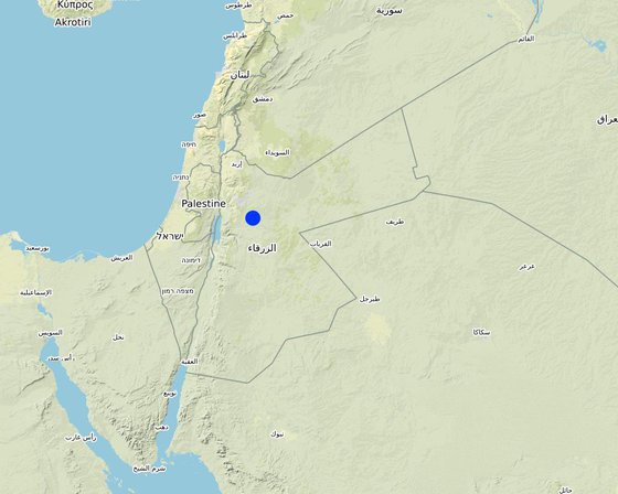
Lugar: Amman governorate/Al Jizza/Al Majeddyeh village, Jordania

No. de sitios de Tecnología analizados: un solo sitio

Georreferencia de sitios seleccionados
  • 36.12826, 31.71933

Difusión de la Tecnología: aplicada en puntos específicos/ concentrada en un área pequeña

¿En un área de protección permanente?: No

Fecha de la implementación: 2017

Tipo de introducción
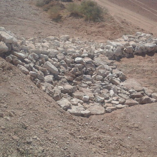
Gully plug construction (Mira Haddad)
Gully plugs during the first rainy season 2017/2018. Photo looking downstream at the top of a gully plug with water ponded and sediment trapped upstream. (Mira Haddad)

Clasificación de la Tecnología

Propósito principal
  • mejorar la producción
  • reducir, prevenir, restaurar la degradación del suelo
  • conservar el ecosistema
  • proteger una cuenca hidrográfica/ áreas corriente abajo – en combinación con otras Tecnologías
  • preservar/ mejorar biodiversidad
  • reducir el riesgo de desastres naturales
  • adaptarse al cambio climático/ extremos climáticos y sus impactos
  • mitigar cambio climático y sus impactos
  • crear impacto económico benéfico
  • crear impacto social benéfico
Uso de tierra
Mezcla de tipos de uso de tierras dentro de la misma unidad de tierras: Sí - Agropastoralismo (incluyendo cultivo-ganado integrados)

  • Tierra de pastoreo
    • Pastoralismo semi-nómada
  • vías fluviales, masas de agua, humedales - Líneas de drenaje, vías fluviales
    Principales productos/ servicios: To convey and drain: Wd
Provisión de agua
  • de secano
  • mixta de secano – irrigada
  • totalmente irrigada

Propósito relacionado a la degradación de las tierras
  • prevenir la degradación del suelo
  • reducir la degradación del suelo
  • restaurar/ rehabilitar tierra severamente degradada
  • adaptarse a la degradación del suelo
  • no aplica
La degradación considerada
  • erosión de suelos por agua - Wg: erosión en cárcavas, Wo: efectos de degradación fuera del sitio
  • deterioro físico del suelo - Pk: desmoronamiento y encostramiento, Pu: pérdida de la función bioproductiva a causa de otras actividades
  • degradación del agua - Hs: cambio en la cantidad de aguas superficiales, Hw: reducción de la capacidad de amortiguación de las áreas humedales
Grupo MST
  • cobertura de suelo/ vegetal mejorada
  • perturbación mínima del suelo
  • medida de pendiente transversal
  • water harvesting; surface water management (spring, river, lakes, sea, riparian zone, riverbanks, seashore, lakeshore, spring shed); ecosystem-based disaster risk reduction
Medidas MST
  • medidas vegetativas - V2: Pastos y plantas herbáceas perennes
  • medidas estructurales - S6: Muros, barreras, vallas, cercas
  • otras medidas - Specify tillage system: no tillage Specify residue management: grazed and retained

Dibujo técnico

Especificaciones técnicas
Emplacement in gully morphological system and watershed context: Determine the downstream starting point for the gully plugs and then extend upstream. The basic design is to keep the structure height maximum half the gully depth regardless of structure type. The spacing between structures is set as a gully depth function, structure crest height above the gully bed, and slope of the gully bed between structures. Additionally, the structure's final location will be shifted either upstream or downstream of the calculated gully bed level to place the structure in a more stable point if required. Following this methodology ensures variable spacing between structures to cope with both slope and depth of gully to ensure the sediment filling in between these structures occurs. In the case of distinct gully morphology and side banks that are very unstable, gabion structures can also be used/instead of a single stone pack.

Design of the Structure: Gully plugs must be anchored strong enough to resist water flow and prevent bypass from the side banks. A foundation is also required for all structures, depending on their dimensions and the bed's nature. At the specific site, the foundation depth for the planned structures ranges between 0.2 to 0.35 meters. The anchoring of gully plugs ranges between 1 and 1.5 meters. This depends on the existing condition of the banks at each structure location. Gully plugs have a downstream apron with a length of around 3 to 4 times the height of structures. The apron starts from below the bottom level of the foundation and gradually level halfway down. All gully plugs were designed to have a height maximum of 0.5 the depth of the gully. So each structure will pass water flow downward but keeping it inside the gully. Gabion structures have a sort of spillway from the top but at the same time protecting the banks. The configuration slightly differs from the normal stone structure, but the idea is to protect the sides and a spillway in the middle. The upstream front of each gully plug has a side slope of 1:1, while the downstream front of the plug has a side slope of 2:1 (not counting the apron). The slopes at the two sides greatly increase the base width of the plug and improve their stability. The gully plugs are provided with an amount of soil resulting from the foundation to form a triangle of soil fill against the structure at the upstream side; this improves the function of the gully plugin holding more water and trapping sediments. On the other side of each structure, the downstream side's slope is meant to tackle the overflow of water along the drop to safely return to the gully bed level without causing additional erosion. The rock-filled apron catches the flow and acts to dissipate erosive energy.
Author: Steve Evett

Establecimiento/ mantenimiento: actividades, insumos y costos

Cálculo de insumos y costos
  • Los costos se calculan: por unidad de Tecnología (unidad: Gully plug)
  • Moneda usada para calcular costos: USD
  • Tasa de cambio (a USD): 1 USD = n.d.
  • Costo promedio por día del sueldo de la mano de obra contratada: n.d.
Factores más determinantes que afectan los costos
The most distinct cost factor is labor – which is especially significant when using local (community) labor; some technical training is required.
Actividades de establecimiento
  1. Implement upland watershed SLM (reference VALLERANI) (Momento/ frequencia: None)
  2. Gully system/morphological assessment (Momento/ frequencia: None)
  3. Determine plug design and implementation in the watershed (Momento/ frequencia: None)
  4. Excavation earthworks for anchors and foundation (Momento/ frequencia: At least 2 months prior rainy season onset)
  5. Stone made construction of gully plugs (occasionally with gabions) (Momento/ frequencia: At least 1 month prior rainy season onset)
  6. Soil pack at upstream front (Momento/ frequencia: At least 1 month prior rainy season onset)
  7. Revegetation of gully side banks (Momento/ frequencia: At the onset of the rainy season)
Insumos y costos para establecimiento (per Gully plug)
Especifique insumo Unidad Cantidad Costos por unidad (USD) Costos totales por insumo (USD) % de los costos cubiertos por los usuarios de las tierras
Mano de obra
Field technician (design and oversight) Labour Day (LD) per structure 0,2 50,0 10,0
Workers (excavation/earthworks) LD 4,0 35,0 140,0
Workers (stone layering/construction) LD 4,0 35,0 140,0
Worker (out-planting of seedlings) LD 1,0 35,0 35,0
Equipo
Shovel, Pickaxe, buckets, ruler Lump sum 1,0 10,0 10,0
Material para plantas
Seedlings per item 10,0 0,5 5,0
Material de construcción
Stones m3 4,0 10,0 40,0
Otros
Logistics (seedling transport, local stone transport) lump sum 1,0 10,0 10,0
Costos totales para establecer la Tecnología 390.0
Costos totales para establecer la Tecnología en USD 390.0
Actividades de mantenimiento
  1. Inspect damage/status (Momento/ frequencia: After severe storms and runoff events)
  2. Maintain/repair/improve (Momento/ frequencia: After inspection)
Insumos y costos de mantenimiento (per Gully plug)
Especifique insumo Unidad Cantidad Costos por unidad (USD) Costos totales por insumo (USD) % de los costos cubiertos por los usuarios de las tierras
Mano de obra
Expert (investigation) LD 0,1 50,0 5,0
LD 0,5 35,0 17,5
LD 1,0 35,0 35,0
Material de construcción
stones m3 0,5 10,0 5,0
Indique los costos totales para mantenecer la Tecnología 62.5
Costos totales para mantener la Tecnología en USD 62.5

Entorno natural

Promedio anual de lluvia
  • < 250 mm
  • 251-500 mm
  • 501-750 mm
  • 751-1,000 mm
  • 1,001-1,500 mm
  • 1,501-2,000 mm
  • 2,001-3,000 mm
  • 3,001-4,000 mm
  • > 4,000 mm
Zona agroclimática
  • húmeda
  • Sub-húmeda
  • semi-árida
  • árida
Especificaciones sobre el clima
Promedio anual de lluvia en mm:130.0
Jordan has a rainy season from September to May – but locally, the effective rainy season sets on later (November or December) and lasts until April.
Nombre de la estación meteorológica: Queen Alia international airport reference station reports long term average annual rainfall of about 150 mm A rainfall tipping bucket installed in the site in 2016.
Pendiente
  • plana (0-2 %)
  • ligera (3-5%)
  • moderada (6-10%)
  • ondulada (11-15%)
  • accidentada (16-30%)
  • empinada (31-60%)
  • muy empinada (>60%)
Formaciones telúricas
  • meseta/ planicies
  • cordilleras
  • laderas montañosas
  • laderas de cerro
  • pies de monte
  • fondo del valle
Altura
  • 0-100 m s.n.m.
  • 101-500 m s.n.m.
  • 501-1,000 m s.n.m
  • 1,001-1,500 m s.n.m
  • 1,501-2,000 m s.n.m
  • 2,001-2,500 m s.n.m
  • 2,501-3,000 m s.n.m
  • 3,001-4,000 m s.n.m
  • > 4,000 m s.n.m
La Tecnología se aplica en
  • situaciones convexas
  • situaciones cóncavas
  • no relevante
Profundidad promedio del suelo
  • muy superficial (0-20 cm)
  • superficial (21-50 cm)
  • moderadamente profunda (51-80 cm)
  • profunda (81-120 cm)
  • muy profunda (>120 cm)
Textura del suelo (capa arable)
  • áspera/ ligera (arenosa)
  • mediana (limosa)
  • fina/ pesada (arcilla)
Textura del suelo (> 20 cm debajo de la superficie)
  • áspera/ ligera (arenosa)
  • mediana (limosa)
  • fina/ pesada (arcilla)
Materia orgánica de capa arable
  • elevada (>3%)
  • media (1-3%)
  • baja (<1%)
Agua subterránea
  • en superficie
  • < 5 m
  • 5-50 m
  • > 50 m
Disponibilidad de aguas superficiales
  • excesiva
  • bueno
  • mediana
  • pobre/ ninguna
Calidad de agua (sin tratar)
  • agua potable de buena calidad
  • agua potable de mala calidad (requiere tratamiento)
  • solo para uso agrícola (irrigación)
  • inutilizable
La calidad de agua se refiere a: agua superficial
¿La salinidad del agua es un problema?
  • No

Incidencia de inundaciones
  • No
Diversidad de especies
  • elevada
  • mediana
  • baja
Diversidad de hábitats
  • elevada
  • mediana
  • baja

Las características de los usuarios de la tierra que aplican la Tecnología

Orientación del mercado
  • subsistencia (autoprovisionamiento)
  • mixta (subsistencia/ comercial)
  • comercial/ mercado
Ingresos no agrarios
  • menos del 10% de todos los ingresos
  • 10-50% de todo el ingreso
  • > 50% de todo el ingreso
Nivel relativo de riqueza
  • muy pobre
  • pobre
  • promedio
  • rico
  • muy rico
Nivel de mecanización
  • trabajo manual
  • tracción animal
  • mecanizado/motorizado
Sedentario o nómada
  • Sedentario
  • Semi-nómada
  • Nómada
Individuos o grupos
  • individual/ doméstico
  • grupos/ comunal
  • cooperativa
  • empleado (compañía, gobierno)
Género
  • mujeres
  • hombres
Edad
  • niños
  • jóvenes
  • personas de mediana edad
  • ancianos
Área usada por hogar
  • < 0.5 ha
  • 0.5-1 ha
  • 1-2 ha
  • 2-5 ha
  • 5-15 ha
  • 15-50 ha
  • 50-100 ha
  • 100-500 ha
  • 500-1,000 ha
  • 1,000-10,000 ha
  • > 10,000 ha
Escala
  • pequeña escala
  • escala mediana
  • gran escala
Tenencia de tierra
  • estado
  • compañía
  • comunitaria/ aldea
  • grupal
  • individual, sin título
  • individual, con título
Derechos de uso de tierra
  • acceso abierto (no organizado)
  • comunitarios (organizado)
  • arrendamiento
  • individual
Derechos de uso de agua
  • acceso abierto (no organizado)
  • comunitarios (organizado)
  • arrendamiento
  • individual
Acceso a servicios e infraestructura
salud

pobre
x
bueno
educación

pobre
x
bueno
asistencia técnica

pobre
x
bueno
empleo (ej. fuera de la granja)

pobre
x
bueno
mercados

pobre
x
bueno
energía

pobre
x
bueno
caminos y transporte

pobre
x
bueno
agua potable y saneamiento

pobre
x
bueno
servicios financieros

pobre
x
bueno

Impacto

Impactos socioeconómicos
producción de forraje
disminuyó
x
incrementó

calidad de forraje
disminuyó
x
incrementó

disponibilidad de agua para ganado
disminuyó
x
incrementó

Impactos socioculturales
seguridad alimentaria/ autosuficiencia
disminuyó
x
mejoró


Some herbs (and fruits (trees) in the future)

oportunidades recreativas
disminuyó
x
mejoró


enhanced biodiversity, shade and shelter

MST/ conocimiento de la degradación del suelo
disminuyó
x
mejoró


Through training/community participation

Impactos ecológicos
calidad de agua
disminuyó
x
incrementó


Certain degree purification through infiltration in the sediment accumulation zone

cosecha/recolección de agua (escurrimiento, rocío, nieve, etc.)
disminuyó
x
mejoró

escurrimiento superficial
incrementó
x
disminuyó


Effect on hydrology (distinctness of runoff peak)

nivel freático/ acuífero
disminuyó
x
recargó


Certain deep-infiltration

evaporación
incrementó
x
disminuyó


more open water ponding – but also deep-infiltration and beneficial use for vegetation (transpiration)

humedad del suelo
disminuyó
x
incrementó

cubierta del suelo
disminuyó
x
mejoró

pérdida de suelo
incrementó
x
disminuyó


Side banks stabilized

acumulación de suelo
disminuyó
x
incrementó


sediments trapped

encostramiento/ sellado de suelo
incrementó
x
disminuyó


sediment crust increased in the ponding area – but better soil structure at the side banks (revegetation) – overall positive impact.

cubierta vegetal
disminuyó
x
incrementó

biomasa/ sobre suelo C
disminuyó
x
incrementó

diversidad vegetal
disminuyó
x
incrementó

diversidad animal
disminuyó
x
incrementó

especies benéficas (depredadores, gusanos de tierra, polinizadores)
disminuyó
x
incrementó

impactos de inundaciones
incrementó
x
disminuyó

deslizamientos/ fluyos de escombros
incrementó
x
disminuyó


Through side bank stabilization.

micro-clima
empeoró
x
mejoró

Impactos fuera del sitio
inundaciones río abajo (no deseadas)
incrementó
x
disminuyó

colmatación río abajo
incrementó
x
disminuyó


especially when combined with upland measure: reference VALLERANI

daño a campos de vecinos
incrementó
x
disminuyó


Less tributary channel development (connectivity of upland areas); less downstream siltation

daños a infraestructura pública / privada
incrementó
x
disminuyó


less runoff peakiness and siltation

Análisis costo-beneficio

Beneficios comparados con los costos de establecimiento
Ingresos a corto plazo:
muy negativo
x
muy positivo

Ingresos a largo plazo
muy negativo
x
muy positivo

Beneficios comparados con costos de mantenimiento
Ingresos a corto plazo:
muy negativo
x
muy positivo

Ingresos a largo plazo
muy negativo
x
muy positivo

During the initial stage potential benefits through vegetation do not materialize; main effects are on water and sediment retention. Long-term, the technology fosters the rehabilitation nature-based retention functions (very limited long-term maintenance required).

Cambio climático

Cambio climático gradual
temperatura anual incrementó

nada bien
x
muy bien
lluvia anual disminuyó

nada bien
x
muy bien
Extremos (desastres) relacionados al clima
tormenta de lluvia local

nada bien
x
muy bien
inundación repentina

nada bien
x
muy bien
enfermedades epidémicas

nada bien
x
muy bien
Otras consecuencias relacionadas al clima
período extendido de crecimiento

nada bien
x
muy bien

Adopción y adaptación

Porcentaje de usuarios de la tierra que adoptaron la Tecnología
  • casos individuales / experimentales
  • 1-10%
  • 11-50%
  • > 50%
De todos quienes adoptaron la Tecnología, ¿cuántos lo hicieron sin recibir incentivos/ pagos materiales?
  • 0-10%
  • 11-50%
  • 51-90%
  • 91-100%
Número de hogares y/ o área cubierta
1
¿La tecnología fue modificada recientemente para adaptarse a las condiciones cambiantes?
  • No
¿A qué condiciones cambiantes?
  • cambios climáticos / extremos
  • mercados cambiantes
  • disponibilidad de mano de obra (ej. debido a migración)

Conclusiones y lecciones aprendidas

Fortalezas: perspectiva del usuario de tierras
  • Gully side bank vegetation useable as (livestock) fodder source; some herbs (later fruit tree benefits) for human consumption.
  • Gully is stable and does not expand e.g. tributaries. Uplands remain connected and productive.
  • Ponded water for livestock watering (during the rainy season).
  • Shelter and shade through vegetation.
Fortalezas: punto de vista del compilador o de otra persona recurso clave
  • Sediments from the uplands are trapped; relatively fertile soil remains in the watershed.
  • Increased local soil moisture and consequential vegetation quantity and bio-diversity enhancement; increase carbon storage and other ecosystem services such as pollination.
  • Smoothened watershed hydrology is beneficial for downstream agriculture – especially when applied in a watershed context with downstream flood irrigation (MARAB)
  • Protection of downstream infrastructure (flooding and sediments).
Debilidades/ desventajas/ riesgos: perspectiva del usuario de tierrascómo sobreponerse
  • implementation costs Incentives (e.g. governmental) for communities to implement SLM; regulations and enforcement on environmental management – especially connected with entitlements of natural resources facilitation
  • Tensions between upstream and downstream watershed users (watershed hydrology) – especially affected through wrong design and failure (e.g. gully breakage) Community-based and holistic watershed management – the share of benefits and commitment for maintenance.
  • Additional fodder supply might attract other foreign herders (overgrazing) Community-based and holistic watershed management – and protection.
  • Technical skills needed for implementation Rural communities’ capacity building programs
Debilidades/ desventajas/ riesgos: punto de vista del compilador o de otra persona recurso clavecómo sobreponerse
  • Expert design and implementation support required Governmental and environmental organizations in control of design and support to local communities (training).
  • Requires upland SLM Integrated watershed management and empowerment of local communities to manage and facilitate – provision of support (e.g. government and/or international projects).
  • Increased vegetation in a fragile ecosystem can lead to local pressure Integrated watershed management and empowerment of local communities – especially sustainable grazing plans
  • Risk of wrong lessons learned: large water harvesting in gully systems (dams) created by locals Capacity development programs; regulations and enforcement on environmental management.

Referencias

Compilador
  • Mira Haddad
Editors
Revisado por
  • William Critchley
  • Rima Mekdaschi Studer
Fecha de la implementación: 9 de marzo de 2021
Últimas actualización: 29 de marzo de 2021
Personas de referencia
Descripción completa en la base de datos de WOCAT
Datos MST vinculados
La documentación fue facilitada por
Institución Proyecto
Referencias claves
  • Steven, E. (2017). Report on Majiddya Watershed Rehabilitation Project - Gully Plugs Plan /August 2017.:
  • Strohmeier, S. (2017). Dimensioning of Marab in Majidyya.:
  • SEA. 1974. Les ouvrages en gabions – techniques rurales en Afrique. Secretariat d’Etat aux Affaires Etrangeres, Republique Francaise, 20, rue Monsieur, 75007 Paris.:
  • FAO. 1977. Guidelines for watershed management. FAO Conservation Guide 1. Food and Agriculture Organization of the United Nations. Rome, 1977:
This work is licensed under Creative Commons Attribution-NonCommercial-ShareaAlike 4.0 International