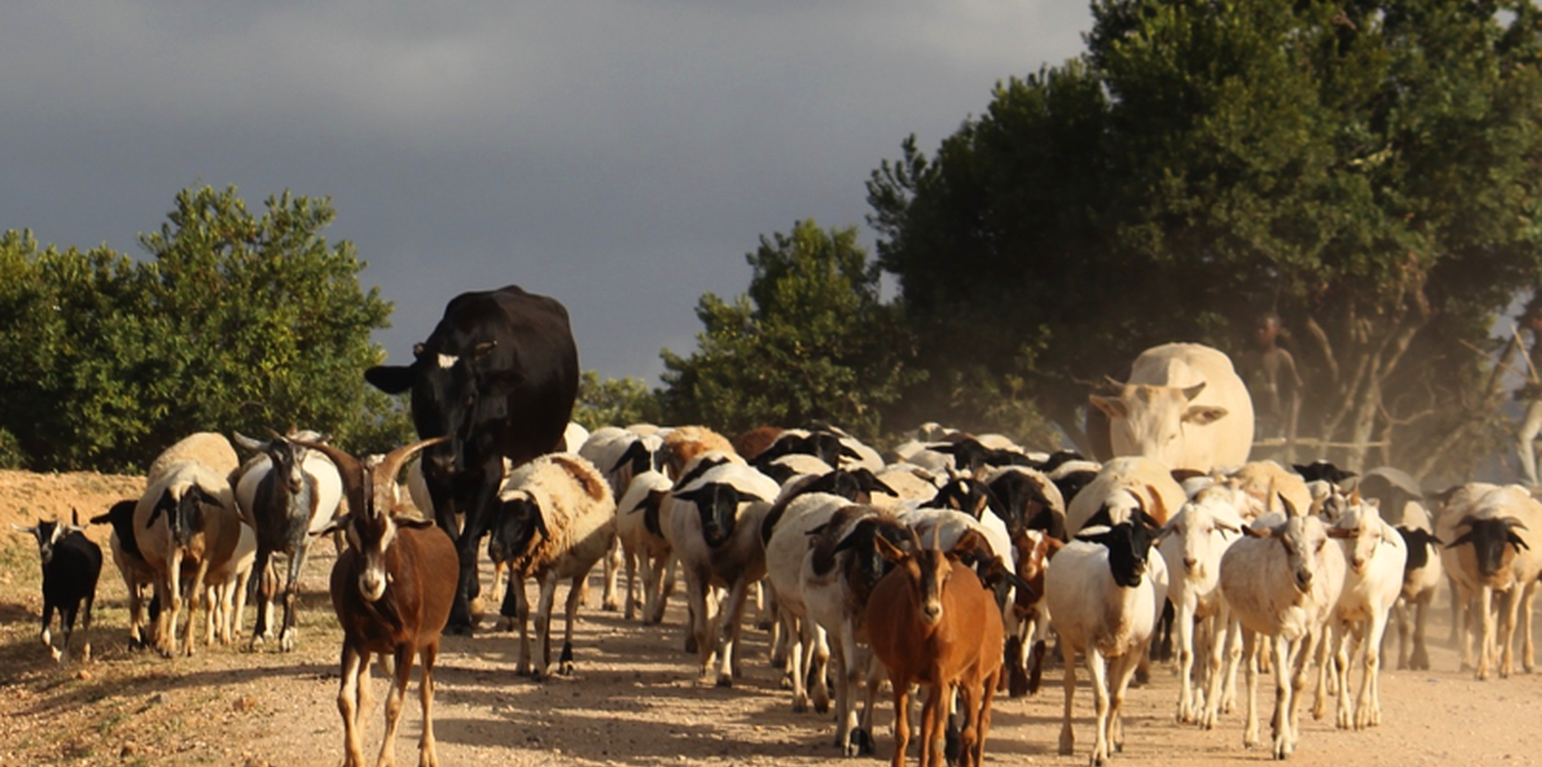
Livestock from Il Ngwesi Group Ranch (Michael Herger)

Il Ngwesi Group Ranch Grazing with Holistic Management Principles (Kenia)

Descripción

A group ranch belonging to the Masai (traditionally, nomad pastoralists) has applied "Holistic Management" grazing principles. The principles consist of separate, planned grazing in villages during the rains, then “bunching” and moving of all animals in herds during the dry season. Denuded land is recovered by a "Boma” technology: i.e. strategic corralling of animals overnight, and reseeding.

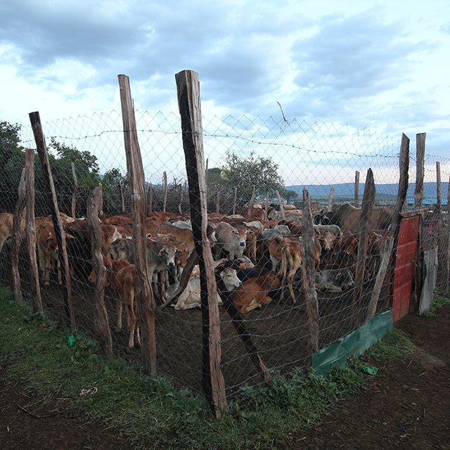
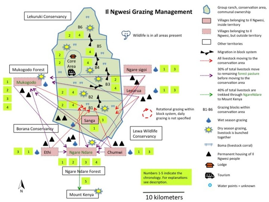
On Il Ngwesi Masai Group Ranch, livestock production management is a combination of traditional livestock keeping and holistic grazing management principles which were introduced in 2007. Livestock production at Il Ngwesi is for subsistence and sales - and has very high cultural significance. 80% of the land is used for conservation, where wildlife and their habitat are protected. The vision is to integrate community development and sustainable environmental management. Holistic Management (HM) was originally conceived by Allan Savory (1988), and is promoted by the Laikipia Wildlife Forum. It integrates decision-making, planning, and livestock keeping. On the land, this means bunching of all livestock close together (in order to act as a "plough" and break the soil to allow seeds, nutrients, and water to infiltrate) resulting in better plant growth. By moving the animals together from block to block, HM aims at managing high numbers of livestock while restoring degraded land. Instead of individual livestock-owning families herding and trekking their own animals, consolidated herds are now managed and moved together, and overseen by herders and supervisors. This allows intensive grazing in restricted areas while resting the remaining land - instead of continuous open grazing. However, Holistic Management principles are still a matter of controversy. While advocates of these management principles do not limit herd sizes, opponents see the root cause of degradation exactly in too high stocking rates. Criticism is plentiful and reviews of the method state that there are no peer-reviewed studies that prove that Holistic Management is superior to conventional grazing systems in outcomes (Carter et al. 2014, Briske et al. 2014).The group ranch land consists of a settlement and a conservation area. The conservation area is further subdivided into a small core zone, measuring 500 hectares and a larger buffer zone of 6,000 hectares. Within this buffer zone, pastoralists are permitted to graze livestock during the dry season.Besides these two main grazing areas in their group ranch, they use additional grazing areas outside their territory such as pasture in forests. In one forest - Mukogodo - they have settled officially; in Ngare Ngare and on Mount Kenya, on the other hand, it is more of an informal agreement. In Il Ngwesi, HM principles are very strictly applied in the conservation area; elsewhere only partly or not at all. During the movements to the forest glades and Mount Kenya, HM principles are maintained as far as possible. This documentation describes the combined grazing management system. During the rains, the grazing system is largely by traditional management: animals remain in and around villages managed individually by households. During the dry season, all livestock are bunched together and managed as one herd.During the wet season, grazing at Il Ngwesi Group Ranch is organized by elders within their seven villages. HM principles are only partly applied. During the dry season, once all the grazing land is eaten, livestock are bunched together and managed by a few herders and overseers. The block system rotation starts. To seek new pasture and water, cattle and smallstock are led to forest glades, and then to the Il Ngwesi conservation area. As soon as the forest pasture is gone, they move on to the conservation area. Usually, this movement of livestock to forests and conservation area starts in February; then they return to the villages in April; and then back to the forests and conservation area until the next rains in November. Whilst the livestock are bunched together, large bomas (corrals in Kiswahili) are constructed for overnight enclosure. Bomas are sited on bare land where dung accumulation and crust breaking by hooves helps rehabilitate land. Every year the boma sites are shifted slightly according to a plan. The total area that can be restored per year is almost 1% of the area of Il Ngwesi.

Lugar

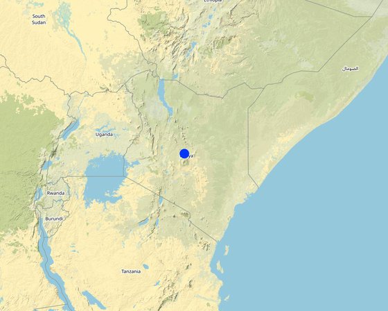
Lugar: Mukogodo Divison, Laikipia, Kenia

No. de sitios de Tecnología analizados: un solo sitio

Georreferencia de sitios seleccionados
  • 37.35378, 0.27867

Difusión de la Tecnología: distribuida parejamente sobre un área (87.0 km²)

¿En un área de protección permanente?:

Fecha de la implementación: 2007

Tipo de introducción
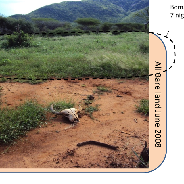
Recovered land on a former boma site in June 2008. The boma was there for only 7 nights. Before, the land looked like the lower half of the picture - bare land. (Laikipia Wildlife Forum (LWF))
Example of a (permanent) boma. Mobile bomas are usually only constructed with cut thorn bush. This boma is not on Il Ngwesi. (Michael Herger)

Clasificación de la Tecnología

Propósito principal
  • mejorar la producción
  • reducir, prevenir, restaurar la degradación de la tierra
  • conservar el ecosistema
  • proteger una cuenca hidrográfica/ áreas corriente abajo – en combinación con otras Tecnologías
  • preservar/ mejorar biodiversidad
  • reducir el riesgo de desastres naturales
  • adaptarse al cambio climático/ extremos climáticos y sus impactos
  • mitigar cambio climático y sus impactos
  • crear impacto económico benéfico
  • crear impacto social benéfico
Uso de tierra

  • Tierra de pastoreo
    • Pastoralismo semi-nómada
    Tipo de animal: camellos, mulas y asnos, ovejas, cattle, shoat
    Productos y servicios: carne, leche
      EspeciesConteo
      mulas y asnos90
      camellos100
    • asentamientos, infraestructura - Asentamientos, edificios
      Comentarios: Villages, bomas, manyattas. 8'000 inhabitans. Lodge for Tourism.

    Provisión de agua
    • de secano
    • mixta de secano – irrigada
    • totalmente irrigada

    Propósito relacionado a la degradación de las tierras
    • prevenir la degradación de la tierra
    • reducir la degradación de la tierra
    • restaurar/ rehabilitar tierra severamente degradada
    • adaptarse a la degradación de la tierra
    • no aplica
    La degradación considerada
    • erosión de suelos por agua - Wt: pérdida de capa arable/ erosión de la superficie , Wg: erosión en cárcavas
    • erosión de suelos por viento - Et: pérdida de capa arable
    • deterioro físico del suelo - Pc: compactación , Pk: desmoronamiento y encostramiento, Pi: sellado de suelo
    • degradación biológica - Bc: reducción de la cobertura vegetal del suelo , Bh: pérdida de hábitats, Bq: reducción de la cantidad/ biomasa, Bs: reducción en la calidad y composición/ diversidad de las especies, Bl: pérdida de la vida del suelo
    Grupo MST
    • pastoralismo y manejo de tierras de pastoreo
    • cobertura de suelo/ vegetal mejorada
    Medidas MST
    • medidas de manejo - M2: Cambio de gestión/ nivel de intensidad , M4: Cambios significativos en la programación de las actividades

    Dibujo técnico

    Especificaciones técnicas
    Grazing map of Il Ngwesi in Mukogodo Division
    Grazing Principles:
    - Rotational, planned grazing
    - Bunching
    - Resting periods for pasture
    - Bomas for bare patches (night corrals)
    Value Chain:
    • Natural Breeding/buying (Ranches & individually)
    • Grazing
    o Settlement area (in red, during the wet season, until pasture is gone, organised by elders, bunching of all animals as soon as it gets dry)
    o Mukogodo Forest / Ngare Ndare Forest (30% of total livestock, remainder to conservation area for grazing directly)
    o Conservation area (6 blocks)
    o Mukogodo Forest/Ngare Ndare Forest/Mount Kenya (Ngare Ndare Forest as corridor to Mount Kenya, about 40% of total livestock goes to Mount Kenya)
    • Need-driven sales to local butcheries/NRT/Ranches
    Il Ngwesi Masai also started to buy land outside their Group Ranch.
    Author: Michael Herger

    Establecimiento/ mantenimiento: actividades, insumos y costos

    Cálculo de insumos y costos
    • Los costos se calculan: por unidad de Tecnología (unidad: Herders, animals treatment. For the whole area affected by livestock (157 km2))
    • Moneda usada para calcular costos: USD
    • Tasa de cambio (a USD): 1 USD = n.d.
    • Costo promedio por día del sueldo de la mano de obra contratada: USD 2.5
    Factores más determinantes que afectan los costos
    - Managing of one big herd, many supervisors needed. - Movement of bomas. - Livestock-owning families (although they obviously don't receive any salary): this is simultaneously their livelihood and used for subsistence. But once all their livestock is bunched in a big herd, they lose their nutritional source (milk, blood) and livelihood (sometimes they keep back a few units for this reason).
    Actividades de establecimiento
    1. Training of elders and community by project leaders (Momento/ frequencia: None)
    2. Grazing planning for bunched animals (livestock from all households) (Momento/ frequencia: None)
    3. Hiring herders, supervisors, watchmen etc (Momento/ frequencia: None)
    Insumos y costos para establecimiento (per Herders, animals treatment. For the whole area affected by livestock (157 km2))
    Especifique insumo Unidad Cantidad Costos por unidad (USD) Costos totales por insumo (USD) % de los costos cubiertos por los usuarios de las tierras
    Mano de obra
    Costs for establishment unknown
    Actividades de mantenimiento
    1. Herders, supervisors, watchmen etc (Momento/ frequencia: None)
    2. Animal treatments (vaccination, spraying, injections) (Momento/ frequencia: None)
    3. Planning activites (Momento/ frequencia: None)
    4. Boma Management (mainly movement of Bomas) (Momento/ frequencia: None)
    Insumos y costos de mantenimiento (per Herders, animals treatment. For the whole area affected by livestock (157 km2))
    Especifique insumo Unidad Cantidad Costos por unidad (USD) Costos totales por insumo (USD) % de los costos cubiertos por los usuarios de las tierras
    Mano de obra
    Herders, watchmen Person-days 250,0 540,0 135000,0 100,0
    Supervisors Person-days 3,0 720,0 2160,0 100,0
    Planning activities, management Person-days 20,0 1500,0 30000,0 100,0
    Livestock-owning families (for wet season, no wages paid, livelihood) Person-days 8000,0 300,0 2400000,0
    Material de construcción
    Boma Movement
    Otros
    Animals treatments (spraying against ticks) Per livestock unit 5000,0 5,0 25000,0 100,0
    Injections, vaccine Per livestock unit 5000,0 3,0 15000,0 100,0
    Indique los costos totales para mantenecer la Tecnología 2'607'160.0
    Costos totales para mantener la Tecnología en USD 2'607'160.0

    Entorno natural

    Promedio anual de lluvia
    • < 250 mm
    • 251-500 mm
    • 501-750 mm
    • 751-1,000 mm
    • 1,001-1,500 mm
    • 1,501-2,000 mm
    • 2,001-3,000 mm
    • 3,001-4,000 mm
    • > 4,000 mm
    Zona agroclimática
    • húmeda
    • Sub-húmeda
    • semi-árida
    • árida
    Especificaciones sobre el clima
    Promedio anual de lluvia en mm:497.0
    Rainfall gauge Borana HQ average from 2013-2016 (neighboring ranch). Strong local (and temporal) variation, changing rainfall regimes. Il Ngwesi is generally drier than Borana. Grazing areas are on different altitudes with different rainfall amounts. While Il Ngwesi Sanga (as one of the villages) is at almost 1700 m a.s.l. with similar rainfall like Borana HQ, Il Ngwesi Conservation area is at 1220 m a.s.l. with significantly lower precipitation (no rainfall gauge). Grazing glades in Mukgodo Forest are at 1850 m a.s.l. and in Ngare Ndare Forest at almost 2100 m a.s.l. (no rainfall measurements available, higher rainfall amounts) and varying heights with much higher precipitation on Mount Kenya (no defined areas).
    Nombre de la estación meteorológica: Rainfall gauge Borana HQ
    Pendiente
    • plana (0-2 %)
    • ligera (3-5%)
    • moderada (6-10%)
    • ondulada (11-15%)
    • accidentada (16-30%)
    • empinada (31-60%)
    • muy empinada (>60%)
    Formaciones telúricas
    • meseta/ planicies
    • cordilleras
    • laderas montañosas
    • laderas de cerro
    • pies de monte
    • fondo del valle
    Altura
    • 0-100 m s.n.m.
    • 101-500 m s.n.m.
    • 501-1,000 m s.n.m
    • 1,001-1,500 m s.n.m
    • 1,501-2,000 m s.n.m
    • 2,001-2,500 m s.n.m
    • 2,501-3,000 m s.n.m
    • 3,001-4,000 m s.n.m
    • > 4,000 m s.n.m
    La Tecnología se aplica en
    • situaciones convexas
    • situaciones cóncavas
    • no relevante
    Profundidad promedio del suelo
    • muy superficial (0-20 cm)
    • superficial (21-50 cm)
    • moderadamente profunda (51-80 cm)
    • profunda (81-120 cm)
    • muy profunda (>120 cm)
    Textura del suelo (capa arable)
    • áspera/ ligera (arenosa)
    • mediana (limosa)
    • fina/ pesada (arcilla)
    Textura del suelo (> 20 cm debajo de la superficie)
    • áspera/ ligera (arenosa)
    • mediana (limosa)
    • fina/ pesada (arcilla)
    Materia orgánica de capa arable
    • elevada (>3%)
    • media (1-3%)
    • baja (<1%)
    Agua subterránea
    • en superficie
    • < 5 m
    • 5-50 m
    • > 50 m
    Disponibilidad de aguas superficiales
    • excesiva
    • bueno
    • mediana
    • pobre/ ninguna
    Calidad de agua (sin tratar)
    • agua potable de buena calidad
    • agua potable de mala calidad (requiere tratamiento)
    • solo para uso agrícola (irrigación)
    • inutilizable
    La calidad de agua se refiere a:
    ¿La salinidad del agua es un problema?
    • No

    Incidencia de inundaciones
    • No
    Diversidad de especies
    • elevada
    • mediana
    • baja
    Diversidad de hábitats
    • elevada
    • mediana
    • baja

    Las características de los usuarios de la tierra que aplican la Tecnología

    Orientación del mercado
    • subsistencia (autoprovisionamiento)
    • mixta (subsistencia/ comercial)
    • comercial/ mercado
    Ingresos no agrarios
    • menos del 10% de todos los ingresos
    • 10-50% de todo el ingreso
    • > 50% de todo el ingreso
    Nivel relativo de riqueza
    • muy pobre
    • pobre
    • promedio
    • rico
    • muy rico
    Nivel de mecanización
    • trabajo manual
    • tracción animal
    • mecanizado/motorizado
    Sedentario o nómada
    • Sedentario
    • Semi-nómada
    • Nómada
    Individuos o grupos
    • individual/ doméstico
    • grupos/ comunal
    • cooperativa
    • empleado (compañía, gobierno)
    Género
    • mujeres
    • hombres
    Edad
    • niños
    • jóvenes
    • personas de mediana edad
    • ancianos
    Área usada por hogar
    • < 0.5 ha
    • 0.5-1 ha
    • 1-2 ha
    • 2-5 ha
    • 5-15 ha
    • 15-50 ha
    • 50-100 ha
    • 100-500 ha
    • 500-1,000 ha
    • 1,000-10,000 ha
    • > 10,000 ha
    Escala
    • pequeña escala
    • escala mediana
    • gran escala
    Tenencia de tierra
    • estado
    • compañía
    • comunitaria/ aldea
    • grupal
    • individual, sin título
    • individual, con título
    Derechos de uso de tierra
    • acceso abierto (no organizado)
    • comunitarios (organizado)
    • arrendamiento
    • individual
    Derechos de uso de agua
    • acceso abierto (no organizado)
    • comunitarios (organizado)
    • arrendamiento
    • individual
    Acceso a servicios e infraestructura
    salud

    pobre
    bueno
    educación

    pobre
    bueno
    asistencia técnica

    pobre
    bueno
    empleo (ej. fuera de la granja)

    pobre
    bueno
    mercados

    pobre
    bueno
    energía

    pobre
    bueno
    caminos y transporte

    pobre
    bueno
    agua potable y saneamiento

    pobre
    bueno
    servicios financieros

    pobre
    bueno

    Impacto

    Impactos socioeconómicos
    producción de forraje
    disminuyó
    incrementó

    calidad de forraje
    disminuyó
    incrementó

    producción animal
    disminuyó
    incrementó

    manejo de tierras
    obstaculizado
    simplificado

    disponibilidad de agua potable
    disminuyó
    incrementó

    disponibilidad de agua para ganado
    disminuyó
    incrementó

    carga de trabajo
    incrementó
    disminuyó


    20-30% above normal (supervision, watchmen, moving big bomas). Previously, every household managed their livestock individually.

    Impactos socioculturales
    seguridad alimentaria/ autosuficiencia
    disminuyó
    mejoró

    derechos de uso de la tierra/ agua
    empeoró
    mejoró

    MST/ conocimiento de la degradación de la tierra
    disminuyó
    mejoró

    mitigación de conflicto
    empeoró
    mejoró


    External! Better land cover attracts invaders (Invasion from northern tribes), envy

    situación de grupos en desventaja social y económica (género, etáreo, estatus, etnicidad, etc.)
    empeoró
    mejoró


    Poorest livestock-owning families are better off now since their livestock are also bunched together with all the others. For instance, before they couldn't afford to trek their 5 cows to Mount Kenya for pasture, now their livestock are trekked with all the others - all have the same opportunities. Other households are complaining about this since they can't decide on their own anymore where they want to bring their livestock for grazing.

    Impactos ecológicos
    cantidad de agua
    disminuyó
    incrementó


    Less runoff, more water stored in the soil.

    escurrimiento superficial
    incrementó
    disminuyó

    nivel freático/ acuífero
    disminuyó
    recargó

    evaporación
    incrementó
    disminuyó

    humedad del suelo
    disminuyó
    incrementó

    cubierta del suelo
    disminuyó
    mejoró

    pérdida de suelo
    incrementó
    disminuyó

    encostramiento/ sellado de suelo
    incrementó
    disminuyó

    compactación de suelo
    incrementó
    disminuyó

    ciclo/ recarga de nutrientes
    disminuyó
    incrementó

    materia orgánica debajo del suelo C
    disminuyó
    incrementó

    cubierta vegetal
    disminuyó
    incrementó

    diversidad vegetal
    disminuyó
    incrementó

    especies invasoras extrañas
    incrementó
    disminuyó


    Il Ngwesi is not affected by the huge invasion of the exotic cactus, Opuntia stricta. However, there are some other invasives like Lantana in the area, but not as problematic as Opuntia. According to land users, native vegetation cover has improved, which results in fewer invasive species.

    impactos de sequías
    incrementó
    disminuyó

    Impactos fuera del sitio
    disponibilidad de agua (aguas subterráneas, manantiales)
    disminuyó
    incrementó


    More stored in the soil. According to the land users, no measurements conducted.

    Análisis costo-beneficio

    Beneficios comparados con los costos de establecimiento
    Ingresos a corto plazo:
    muy negativo
    muy positivo

    Ingresos a largo plazo
    muy negativo
    muy positivo

    Beneficios comparados con costos de mantenimiento
    Ingresos a corto plazo:
    muy negativo
    muy positivo

    Ingresos a largo plazo
    muy negativo
    muy positivo

    Cambio climático

    Cambio climático gradual
    Greater variation of seasonal rainfall, higher intensity of rainfall events, change in rainfall regimes in general (see Schmocker 2013 and Imfeld 2016). incrementó

    nada bien
    muy bien
    Extremos (desastres) relacionados al clima
    ola de calor

    nada bien
    muy bien

    Adopción y adaptación

    Porcentaje de usuarios de la tierra que adoptaron la Tecnología
    • casos individuales / experimentales
    • 1-10%
    • 11-50%
    • > 50%
    De todos quienes adoptaron la Tecnología, ¿cuántos lo hicieron sin recibir incentivos/ pagos materiales?
    • 0-10%
    • 11-50%
    • 51-90%
    • 91-100%
    Número de hogares y/ o área cubierta
    50%
    ¿La tecnología fue modificada recientemente para adaptarse a las condiciones cambiantes?
    • No
    ¿A qué condiciones cambiantes?
    • cambios climáticos / extremos
    • mercados cambiantes
    • disponibilidad de mano de obra (ej. debido a migración)
    Masai people have changed their livestock composition towards owning more smallstock (goats and sheep) than cattle. Goats are tolerant of drought, and as browsers, they don't need any grass. Also, they can be turned into money much quicker than a cow in times of need and because of their more rapid reproductive cycle. They can also recover number more quickly after livestock losses through drought.

    Conclusiones y lecciones aprendidas

    Fortalezas: perspectiva del usuario de tierras
    • Proper utilisation of pasture – controlled usage/grazing.
    • Land recovery (more cover, more water, more fodder, less erosion).
    • Carrying capacity increased.
    • Traditional knowledge is still used.
    • More dialogue in community: brings everyone in the community together – they have a common point – everyone has the same interest.
    • Improving breeds is easier (because all are bunched together).
    • Easy vaccination of all livestock at once.
    • Approving cultural lifestyle of Masai: the higher the livestock numbers – the better for the land.
    • Better for disadvantaged community members: for instance for those who could not afford to move their livestock to Mt Kenya on their own before.
    Fortalezas: punto de vista del compilador o de otra persona recurso clave
    • The listed advantages from Patrick Leseri, the land user, are for the most part shared share with the compiler's view. Improved planning of livestock production with planned grazing and long resting periods, improved dialogue in the community, and the named advantages of a big herd (like easy vaccination etc) are important advantages. Regarding Holistic Management (HM) principles, there remains uncertainty about land recovery. On the one hand, it is generally questionable to state as in HM: “the more animals the better” (as long as they are managed properly they can even recover degraded land), which seems dangerous in areas with such high livestock numbers and cultural value of livestock keeping - without scientific proof of the principles in similar ecological conditions. We have witnessed rather poor condition of the land, and the much-vaunted good land was difficult to find. Favourable descriptions might also be related to funding of the project. Results from a rangeland health assessment show (partly) heavily degraded ecological conditions (bare ground, poor soil and vegetation, erosion features, partly an inability of producing perennial and annual grasses after rains etc) (see Herger 2018). However, an evaluation of change over time is impossible to assess. Further monitoring is necessary. Land users and experts are aware that the ecological conditions of this Group Ranch are still far from optimal, but do see good progress and exemplary management as well as slightly better conditions than on other Group Ranches. However, the efforts towards good management and a sense of community was not difficult to notice.
    Debilidades/ desventajas/ riesgos: perspectiva del usuario de tierrascómo sobreponerse
    • Higher costs. Above 20% more than normal costs. Northern Rangeland Trust (NRT), Laikipia Wildlife Forum and Lewa conservancy as main funders for applying holisitc management principles. Since 2007, they covered about 50% of all costs..
    • More labour intensive. 20-30% above normal (supervision, watchmen, moving big bomas).
    • Challenge to bring people together (and their livestock) and agree on a joint management.
    • Some families still prefer to manage their livestock on their own and make their own decisions. There are no individual decisions anymore: principles apply to everyone.
    • Breeding can also be a problem – those with good genetic material (better livestock) may lose and those with poor may win by mixing.
    • Conflicts among animals; bulls fight a lot. No separation of heifers, cows, steers and bulls.
    • Management of high numbers of big herds is a challenge.
    • Diseases are easily transmitted.
    • Once livestock is collected to big herds, individual families lose their nutritional basis (milk, blood). However, some also keep a few livestock units back.
    • Sometimes trees are cut for bomas.
    Debilidades/ desventajas/ riesgos: punto de vista del compilador o de otra persona recurso clavecómo sobreponerse

    Referencias

    Compilador
    • Michael Herger
    Editors
    Revisado por
    • Joana Eichenberger
    • Donia Mühlematter
    • Brigitte Zimmermann
    • Rima Mekdaschi Studer
    • Alexandra Gavilano
    • Hanspeter Liniger
    Fecha de la implementación: 20 de abril de 2017
    Últimas actualización: 2 de noviembre de 2021
    Personas de referencia
    Descripción completa en la base de datos de WOCAT
    Datos MST vinculados
    La documentación fue facilitada por
    Institución Proyecto
    Referencias claves
    • Herger, M.B. (2018). Environmental Impacts of Red Meat Production. MSc Thesis. University of Bern.: University of Bern
    • Modeling Seasonal and Annual Precipitation using long-term Climate Records and Topography. Master’s Thesis. Noemi Imfeld (2016).: University of Bern
    • Savory, A (1988). Holistic Resource Management. Gilmour Publishing, Harare, Zimbabwe: Online
    • •Carter, J., Jones, A., O’Brien, M., Ratner, J., Wuerthner, G. (2014). Holistic Management: Misinformation on the Science of Grazed Ecosystems.: International Journal of Biodiversity.
    • •Briske, D.D., Ash, A.J., Derner, J.D., Huntsinger, L. (2014). Commentary: A critical assessment of the policy endorsement for holistic management. Agricultural Systems 125:50-53.:
    This work is licensed under Creative Commons Attribution-NonCommercial-ShareaAlike 4.0 International