Participatory mapping, database building, and monitoring of rangeland resources
(Kenia)
Resource Mapping
Descripción
Participatory mapping and monitoring of vegetation types and other natural resources in the rangelands. This involves convening stakeholder groups, reviewing conditions of rangeland, water and other resources under changing climatic conditions.
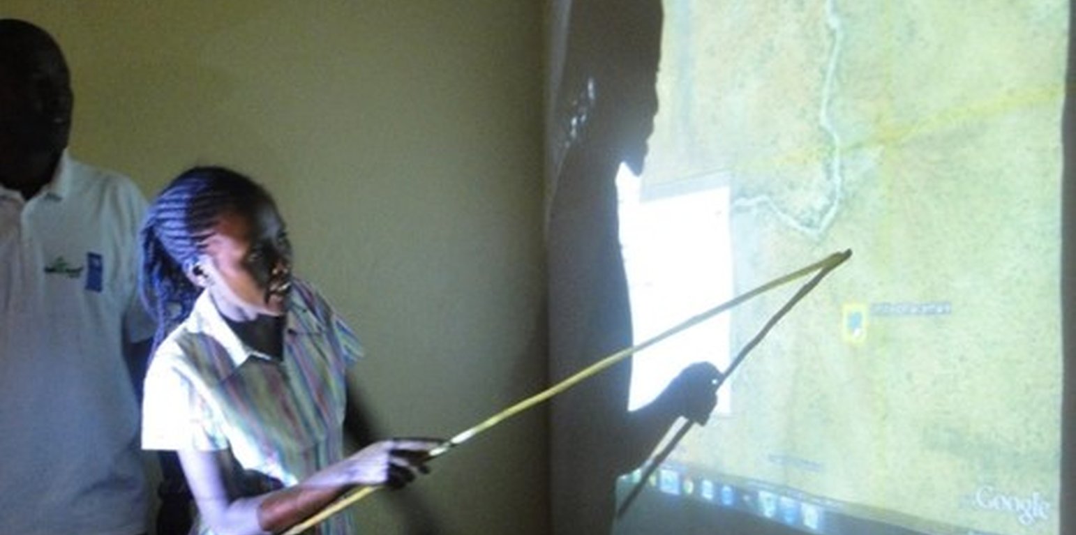
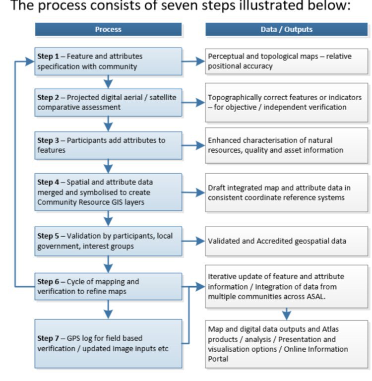
Participatory digital mapping using satellite imagery and digital earth and other open source Geographic Information Systems (GIS) is a practical tool that can bridge knowledge and communication gaps between pastoral communities and county government planners. It offers an effective ‘tool’ for participatory planning and decision-making in support of climate change adaptation efforts in the drylands of Kenya.The use of participatory mapping is not new in seeking to capture communities’ understanding and use of natural resources. These maps are typically drawn on the ground using stones, sticks and other locally available materials to depict key features such as schools, water points, and forest areas, etc. However the process used in Isiolo County combines digital mapping with community-drawn perception maps. This offers a number of extra benefits. While fully capturing the wealth of local knowledge, they contain an in-built coordinate system which corresponds to a global reference grid, enabling their linkage to maps used in formal systems. Furthermore, the coordinate system provides a geographically precise basis from which to discuss natural resource management, making outputs of participatory mapping more universally useable. These benefits, however, need to be carefully balanced to avoid the risk that through this process, pastoral resources – which are highly dynamic - are ‘frozen’ in time and space. Mapping processThe participatory mapping process has adopted GIS workflows within community workshops, enabling the creation of integrated, consistent and standardized geospatial information. The process follows seven steps:Step 1: Community level meetings to develop perception maps drawn on the ground and/or on paper. The product is a community perception map of those resources that are important for their livelihood systems. This map should be created in a community setting to enable the participation of a large group. Several maps may be produced by smaller sub-groups (women, the youth, elders etc) and then amalgamated. The final map is then copied onto paper. Step 2. Digital mapping is introduced. This step takes place in a workshop setting with a smaller group of key informants chosen by the community - as well as county government planners and technical staff. The presence of the latter is critical to the process of ‘legitimizing’ community knowledge. Following a quick explanation of satellite imagery, Google Earth is projected onto a wall alongside the perception maps developed under step 1. The use of Google Earth is only for orientation, and to enable participants to navigate the imagery and to cross-reference their paper-mapped key resources against the satellite imagery. Features that participants feel are important (e.g. water points, wet and dry season grazing areas, drought reserves, wildlife routes) are then captured digitally using open source applications: Quantum GIS (QGIS) and JOSM, the Open Street Map editing platform.This produces the coordinates that pinpoint the locations of natural resources in a manner that can be independently and objectively verified. The highly interactive process of geo-referencing local knowledge to a coordinate reference system allows resource maps to be produced to any scale, and in real-time, with the community. Step 3. Qualitative and quantitative attributes describing the key resources are collected. As participants add features to the map, they also describe their specified characteristics or attributes. Attribution data includes a fuller description of the physical characteristics of the resource (e.g. soil type, waterquantity and quality, pasture species) as well as issues concerning their management (e.g. under customary or modern management, land tenure status, negotiated or paid access, area of conflict). Updating this data on a regular basis adds temporal and trend data to the spatial database. This underlines the need to structure data systems well to manage time-based data and to record updates.Steps 4-6: Data verification cycles are integrated into the mapping process in order to capture community feedback and verify the records in the geospatial data and their attribute values against the specification. The mapping includes a series of validation, cross-checking and verification cycles, run with the community - and in a few instances on-the-ground verification termed ‘groundtruthing’. Step 7: Field validation. Field validation is carried out where the verification stages highlight gaps in information. Verification consists of targeted field visits to take GPS markers, or holding meetings with the local community to clarify particular issues.
Lugar
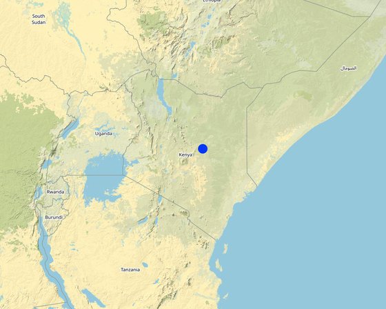
Lugar: Pasturalist areas, Isiolo, Kenia
Georreferencia de sitios seleccionados
Dato de inicio: 2012
Año de conclusión: 2015
Tipo de Enfoque
-
tradicional/ local
-
iniciativa local reciente/ innovadora
-
proyecto/ basado en un programa
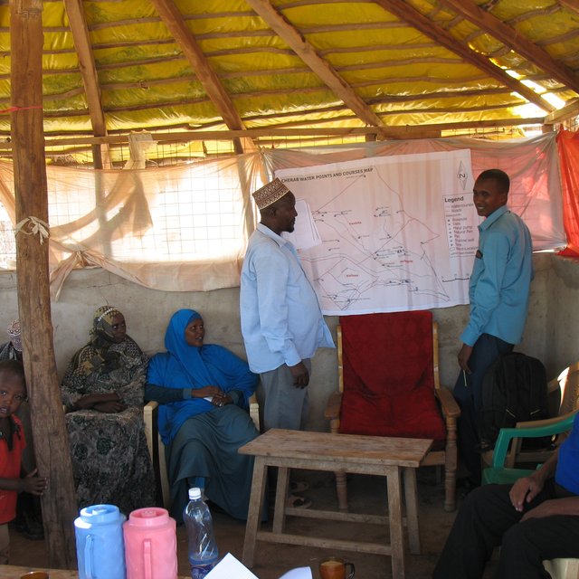
Participatory resource mapping in Dadacha Bassa (Caroline King Okumu)
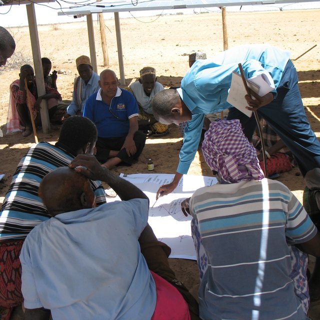
Participatory resource mapping under solar panels inMerti (Caroline King Okumu)
Metas del Enfoque y entorno facilitador
Propósitos/ objetivos principales del Enfoque
- To allow participation for community groups to inform planners.- To provide the necessary precision for planners to use local knowledge effectively.- To make a ‘bridge’ for information to flow between customary and formal institutions.- To better share ideas through communication tools using powerful visual language.- To demonstrate the depth of local knowledge about natural resources and with that, demonstrate the importance of these resources.- To identify gaps and risks in the system being mapped.- To compare one plan with another to see how complimentary/contradictory they are.
Condiciones que facilitan la implementación de la/s Tecnología/s aplicadas bajo el Enfoque
-
Normas y valores sociales/ culturales/ religiosos: Communities are awed by the technology that allows them to see their resources while seated in a single specific location. The approach doesn't conflict with any community social, cultural, religious norms and values.
-
Disponibilidad/ acceso a recursos y servicios financieros : A brief GIS training of four weeks can allow county government staff to develop, add and update the database.
-
Entorno institucional: The approach helps in improving planning at community and government levels, and is accepted by all stakeholders.
-
Colaboración/ coordinación de actores: The product of the participatory mapping process is beneficial to all actors and many are willing to engage in implementation of the approach.
-
Marco de trabajo legal (tenencia de tierra, derechos de uso de tierra y agua): The approach helps in land use planning and supports regulations meant to improve land governance such as a customary natural resource management bill.
-
Políticas: Many policies and laws (including the national constitution) support the mapping of resources to improve land use planning.
-
Gobernanza de tierras (toma de decisiones, implementación y aplicación): The approach allows communities to develop their land use plans for resource utilisation, and digitize them - making the work of land governance easier.
-
Conocimiento de MST, acceso a apoyo técnico: New graduates in dryland resource management, and communities' reception of the new technologies, help in acceptance and implementation of the technology.
-
Mercados (para comprar insumos, vender productos) y precios: Free open source programmes are available to digitize local knowledge to geo-referenced products.
-
Carga de trabajo, disponibilidad de mano de obra: The technology makes the process simpler and reduces the workload.
Condiciones que impiden la implementación de la/s Tecnología/s aplicadas bajo el Enfoque
-
Normas y valores sociales/ culturales/ religiosos: Minimal local capacity is required to use the technology.
-
Disponibilidad/ acceso a recursos y servicios financieros : Short GIS training courses costs around $850 and facilitation of community engagement meetings may be costly to undertake.
-
Entorno institucional: Poor capacity and financial resources can be a challenge.
-
Colaboración/ coordinación de actores: Different mapping initiatives are undertaken by actors with various objectives.
-
Marco de trabajo legal (tenencia de tierra, derechos de uso de tierra y agua): County governments can develop their own spatial plans, but there are only few initiatives underway to map county resources
-
Políticas: Conflicts over land undermines political will.
-
Gobernanza de tierras (toma de decisiones, implementación y aplicación): Competing claims over land and land-based resources in community lands means enforcement of the approach is often challenged. Resources along administrative boundaries are claimed by different communities.
-
Conocimiento de MST, acceso a apoyo técnico: 58% of the residents of the county (according to the Kenya National Bureau of Statistics socio-economic survey report of 2016) are illiterate and may have difficulties engaging properly with the technology.
-
Mercados (para comprar insumos, vender productos) y precios: Good programmes for mapping are expensive.
-
Carga de trabajo, disponibilidad de mano de obra: The processes can be tedious because of the paper maps involved, series of validation and verification of features.
Participación y roles de las partes interesadas involucradas
Partes interesadas involucradas en el Enfoque y sus roles
| ¿Qué partes interesadas/ entidades implementadoras estuvieron involucradas en el Enfoque? |
Especifique las partes interesadas |
Describa los roles de las partes interesadas |
| usuarios locales de tierras/ comunidades locales |
Jarsa Dedha (customary natural resource management institutions) Community Members (i.e. pastoralists). |
Jarsa Dedha identify the most knowledgeable elders from different grazing areas to help in identifying features and providing grazing land management plans that are in place. Community members identify features and contribute to the attributes of the features. |
| organizaciones comunitarias |
Kinna Integrated community based initiative (KICBI)Ward Adaptation Planning Committees |
They identify features and also contribute to attributes of the features |
| especialistas MST/consejeros agrícolas |
Ibrahim Jarso |
Support mapping process and also add new features supporting updates to the products. |
| ONG |
Resource Advocacy Program (RAP)Merti Integrated Development Program (MID-P)Adaptation Consortium |
Support the mapping process and mobilize communities and stakeholders for the approach to be implemented properly. |
| gobierno local |
Isiolo County Government |
Support the mapping process with intention to use product for planning purpose and own the product |
| gobierno nacional (planificadores, autoridades) |
Kenya's National Government |
Support the planning process - also with the intention of using the product for planning. |
| organización internacional |
International Institute for Environment and Development (IIED) and theUniversity of Southampton (Geodata Institute) |
Support with funding to implement the approach and also provide technical expertise to undertake GIS processing of data. |
Agencia líder
WAPC , ADA and IIED
Involucramiento de los usuarios locales de tierras/ comunidades locales en las distintas fases del Enfoque
ninguno
pasivo
apoyo externo
interactivo
auto-movilización
iniciación/ motivación
Resource Advocacy Programme (RAP) undertook discussions with the local community and also with the county and national government in shaping the idea for the approach.
planificación
All stakeholders (community, RAP, ADA, IIED, Geodata and Governments) were engaged in the planning for the implementation of the Approach.
implementación
Community members and all stakeholders were involved in the implementation of the participatory mapping.
monitoreo y evaluación
The county government and the actors (RAP, ADA and IIED) monitor the participatory mapping database and improves it.
Flujograma
Participatory mapping of community resources has seven steps, which can be summarised under the main groupings of: consultations with the community where key features are identified and mapped on paper; digitization of community identified points by GIS specialists; processing of the data where community identified attributes are incorporated into the data; and feedback sessions for community validation and verification.
Autor: Ibrahim Jarso
La toma de decisiones en la selección de Tecnología MST
Las decisiones fueron tomadas por
-
solamente usuarios de tierras (autoiniciativa)
-
principalmente usuarios de tierras con el apoyo de especialistas MST
-
todos los actores relevantes, como parte de un enfoque participativo
-
principalmente por especialistas MST en consulta con usuarios de tierras
-
solo por especialistas MST
-
por políticos/ líderes
La toma de decisiones se basa en
-
la evaluación de conocimiento MST bien documentado (la toma de decisiones se basa en evidencia)
-
hallazgos de investigaciones
-
la experiencia personal y opiniones (no documentadas)
Apoyo técnico, fortalecimiento institucional y gestión del conocimiento
Las siguientes actividades o servicios fueron parte del enfoque
-
Construcción de capacidades / capacitación
-
Servicio de asesoría
-
Fortalecimiento institucional (desarrollo institucional)
-
Monitoreo y evaluación
-
Investigación
Construcción de capacidades/ capacitación
Se proporcionó capacitación a las siguientes partes interesadas
-
usuarios de tierras
-
personal de campo/ consejeros
Forma de capacitación
-
en el contexto de trabajo
-
de agricultor a agricultor
-
áreas de demostración
-
reuniones públicas
-
cursos
Temas avanzados
Participatory GIS mapping techniquesInput of data using different platformsUse of GPS devicesValidation of dataData management
Servicio de asesoría
Se proporcionó servicio de asesoría
-
en los campos de los usuarios de tierras
-
en centros permanentes
practical sessions were provided in the field and with communities
Fortalecimiento institucional
Se fortalecieron/ establecieron instituciones
-
no
-
sí, un poco
-
sí, moderadamente
-
sí, mucho
Describa la institución, los roles y las responsabilidades, miembros, etc.
Local institutions were able to use the maps to advocate for improved planning.
Tipo de apoyo
-
financiero
-
construcción de capacidades/ entrenamiento
-
equipo
Detalles adicionales
Courses/trainings were provided
Monitoreo y evaluación
inputs were monitored
Investigación
La investigación trató los siguientes temas
-
sociología
-
economía/ marketing
-
ecología
-
tecnología
Research on vegetation patterns in Isiolo’s rangelands were conducted by the University of Nairobi's Department of Land and Resource Management.
Financiamiento y apoyo material externo
Presupuesto anual en dólares americanos para el componente MST
-
< 2,000
-
2,000-10,000
-
10,000-100,000
-
100,000-1,000,000
-
> 1,000,000
Precise annual budget: n.d.
The approach was supported by RAP and IIED under the Adaptation Consortium with funding from UK's Department for International Development (DfID). The budget is used to convene sub-county level meetings and trainings sessions. Many of the participants costs and preparation costs are not covered.
Los siguientes servicios o incentivos fueron proporcionados a los usuarios de las tierras
-
Apoyo financiero/material proporcionado a los usuarios de tierras
-
Subsidios para insumos específicos
-
Crédito
-
Otros incentivos o instrumentos
parcialmente financiado
totalmente financiado
mano de obra
Community meetings were supported by the actors in the project (RAP, IIED and Adaptation Consortium).
equipo: maquinaria
Machinery used in the approach was purchased by the actors involved.
El trabajo de los usuarios de las tierras fue
-
voluntario?
-
comida por trabajo?
-
pagado en efectivo?
-
recompensado con otro tipo de apoyo material?
Análisis de impacto y comentarios de conclusión
Impactos del Enfoque
No
Sí, un poco
Sí, moderadamente
Sí, mucho
¿El Enfoque empoderó a los usuarios locales de tierras, mejoró el involucramiento de las partes interesadas?
Yes, the approach strengthens community rights and management of resources.
¿El Enfoque facilitó la toma de decisiones basada en evidencia?
Yes greatly – provided databases that did not previously exist.
¿El Enfoque ayudó a los usuarios de tierras a implementar y mantener Tecnologías MST?
Strengthened the traditional system of management of land.
¿El Enfoque mejoró la coordinación e implementación efectiva en costos de MST?
Improved coordination among the partners and enabled monitoring of resource conditions.
¿El Enfoque mejoró el conocimiento y capacidades de los usuarios para implementar MST?
The technology provided digitized observation of resources, and communities realised their wealth of their resources.
¿El Enfoque mejoró el conocimiento y capacidades de otras partes interesadas?
The Community resource atlas of Isiolo County has been online since July 2015.
¿El Enfoque mitigó conflictos?
The Approach mapped conflict hotspots and improved the process of conflict resolution and analysis.
¿El Enfoque mejoró la equidad de género y empoderó a las mujeres y niñas?
The process also engaged women in gathering local knowledge of resources and they made a very considerable contribution to the work.
¿El Enfoque alentó a jóvenes/ la siguiente generación de usuarios de tierras a involucrarse con MST?
The use of GIS fascinated young people and they felt attracted to the process.
¿El Enfoque mejoró cuestiones de tenencia de tierra/ derechos de usuarios que obstaculizaron la implementación de la Tecnologías MST?
The approach guided use of land and also strengthened communities ownership and rights over their land and their available resources.
¿El Enfoque llevó a un acceso mejorado a tierra y saneamiento?
The approach guided water investments in the community lands and improved placement of water infrastructure.
¿El Enfoque llevó a un uso más sostenible/ fuentes de energía?
The approach mapped boreholes, and the energy used to extract water from them, as well as encouraging use of clean and green energy.
¿El Enfoque mejoró la capacidad de los usuarios de tierras a adaptarse a los cambios climáticos/ extemos y mitigar desastres relacionados al clima?
The approach concretized the community land use plans and guided proper use of their pasture and water - enhancing the community's capacity to adapt to climate related disasters of drought and floods.
Motivación principal del usuario de la tierra para implementar MST
-
producción incrementada
-
incremento de la renta(bilidad), proporción mejorada de costo-beneficio
-
reducción de la degradación de la tierra
-
reducción del riesgo de desastres naturales
-
carga de trabajo reducida
-
pagos/ subsidios
-
reglas y reglamentos (multas)/ aplicación
-
prestigio, presión social/ cohesión social
-
afiliación al movimiento/ proyecto/ grupo/ redes
-
conciencia medioambiental
-
costumbres y creencias, moral
-
conocimiento y capacidades mejorados de MST
-
mejoramiento estético
-
mitigación de conflicto
Sostenibilidad de las actividades del Enfoque
¿Pueden los usuarios de tierras sostener lo que se implementó mediante el Enfoque (sin apoyo externo)?
Conclusiones y lecciones aprendidas
Fortalezas: perspectiva del usuario de tierras
-
It is a promising new approach that builds on the legitimacy of local/indigenous knowledge, and enables the county government to fulfil its mandate of undertaking participatory planning with communities.
-
GIS technology helps in the acceptance of the approach by many land users.
-
The mobililty of the technology can provide an opportunity for all community members to add features as they come up
Fortalezas: punto de vista del compilador o de otra persona recurso clave
-
It is a user friendly approach accepted and recognized by Isiolo pastoralists for mapping their rangeland resources.
-
It provides an opportunity to map all investments of development partners in the county and avoid duplication of projects.
-
It is a powerful tool for communication and advocacy for community land rights.
Debilidades/ desventajas/ riesgos: perspectiva del usuario de tierrascómo sobreponerse
-
It requires time and commitment from community members and county officers.
Systematic use of media (e.g. radio, websites, etc) to publicize the approach and its importance to the community.
-
It is difficult for illiterate community members to fully engage with the approach and make meaningful contributions.
Provide local translations and interpretation as well as producing good visual maps.
Debilidades/ desventajas/ riesgos: punto de vista del compilador o de otra persona recurso clavecómo sobreponerse
-
There is a need for continuous updating
Engage local universities and students.
-
Observation of key features and resources are sometimes obscured by clouds and thus mapping precision is affected.
Ground truthing visits and observations need to be undertaken to improve precision.
-
Lack of legislation to support and enforce the use of the approach.
Formulate legislation to support enforcement.
Referencias
Revisado por
-
Hanspeter Liniger
-
Rima Mekdaschi Studer
-
Donia Mühlematter
-
Joana Eichenberger
Fecha de la implementación: 13 de marzo de 2018
Últimas actualización: 2 de noviembre de 2021
Personas de referencia
-
IBRAHIM JARSO (jarsoibra@gmail.com) - Especialista MST
-
Hussein Konsole (saritehussein@yahoo.com) - Usuario de la tierra
-
Shandey Abdullahi (midp2003@gmail.com) - Non-State Actor
-
Caroline King-Okumu (caroking@yahoo.com) - Especialista MST
Descripción completa en la base de datos de WOCAT
La documentación fue facilitada por
Institución
- Resource Advocacy Programme (RAP) - Kenia
Proyecto
- Book project: Guidelines to Rangeland Management in Sub-Saharan Africa (Rangeland Management)
- Strengthening Adaptation and Resilience to Climate Change in Kenya Plus (StARCK+)
Referencias claves
-
Participatory Mapping using Digital Earth Tools, Imagery and Open Source GIS in the drylands of Kenya and Tanzania by Chris Hill, Tom Rowley, Homme Zwaagstra, Andrew Harfoot and Mike Clark: Ada Consortium Website
Vínculos a la información relevante disponible en línea