Closing off a gully with a permeable rock dam. (PGRNG Mauritanie, GIZ)

Permeable rock dams (Burkina Faso)

Digues filtrantes (French)

Descripción

Permeable rock dams serve to restore seriously degraded farmland and forest/rangeland and are used to fill in gullies and control water flow.

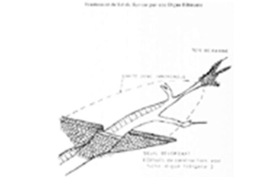
The permeable rock dam is a structure built in gullies using loose rocks and stones and sometimes reinforced with gabions. A filtering layer (blanket of gravel or small stones) is laid in a foundation trench. Further layers of medium-sized and large stones and rocks are laid on top. They are between 0.50 and 3 metres high, and the width of the foundation and the crest depends on the estimated volume of water flow. The structure built across the gully is extended to the sides with the construction of wingwalls that spread the water over a larger area to the sides of the dam. The total width of the structure is generally at least three times its height. The dams can be constructed with or without a spillway. A spillway is required when flood water flow is stronger.

Purpose of the Technology: Permeable rock dams are used to fill in gullies and control water flow. They slow the flow of floodwaters and spread the water over adjacent land. This improves infiltration, and sediment builds up behind the dams. In time, the sediment fills in the gully. This stops lateral drainage from the land on either side, increasing its productivity. High infiltration upstream of the dam contributes to recharging the groundwater system. These structures are therefore also effective in raising the water table in wells and in protecting the bottom-lands from sand filling and gully erosion. They are used in combination with other measures, such as reforestation and stone bunds, to protect and improve the surrounding area, and to increase the area of land that can be used for growing crops.
By dissipating the flow of floodwaters, they ensure better use of rainwater and are therefore important in dry periods. The conservation of water for longer periods and the fine particles of earth trapped by the structure favour the establishment of natural vegetation along it, which helps to stabilise the dam. Seeds are also trapped, favouring the spontaneous growth of grass and trees upstream and downstream, which contributes to restoring and conserving biodiversity.

Establishment / maintenance activities and inputs: The sustainability of permeable rock dams depends on the quality of construction and whether they are maintained regularly. A certain amount of expertise and good community organisation is required to repair any cracks in
the dam. Biological measures (sowing grass and planting trees) increase the stability of the structure.
The size of a permeable rock dam can vary considerably from one site to another. The cost is also affected by the distance of the site from the quarry, the topography of the terrain and the actual amount of rock carried in each lorryload. It costs less to construct this type of structure with loose stones and rocks than with gabions.
Lugar

Lugar: Burkina Faso, Chad, Burkina Faso

No. de sitios de Tecnología analizados:

Georreferencia de sitios seleccionados
  • -1.57827, 12.29511

Difusión de la Tecnología:

¿En un área de protección permanente?:

Fecha de la implementación: 10-50 años atrás

Tipo de introducción
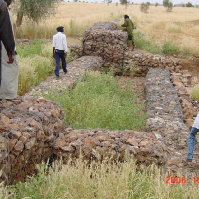
Spillway of a permeable rock dam with stilling basin (PGRNG Mauritanie, GIZ)

Clasificación de la Tecnología

Propósito principal
  • mejorar la producción
  • reducir, prevenir, restaurar la degradación del suelo
  • conservar el ecosistema
  • proteger una cuenca hidrográfica/ áreas corriente abajo – en combinación con otras Tecnologías
  • preservar/ mejorar biodiversidad
  • reducir el riesgo de desastres naturales
  • adaptarse al cambio climático/ extremos climáticos y sus impactos
  • mitigar cambio climático y sus impactos
  • crear impacto económico benéfico
  • crear impacto social benéfico
Uso de tierra
Mezcla de tipos de uso de tierras dentro de la misma unidad de tierras: Sí - Agropastoralismo (incluyendo cultivo-ganado integrados)

  • Tierras cultivadas
    • Cosecha anual
    Número de temporadas de cultivo por año: 1
  • Tierra de pastoreo

Provisión de agua
  • de secano
  • mixta de secano – irrigada
  • totalmente irrigada

Propósito relacionado a la degradación de las tierras
  • prevenir la degradación del suelo
  • reducir la degradación del suelo
  • restaurar/ rehabilitar tierra severamente degradada
  • adaptarse a la degradación del suelo
  • no aplica
La degradación considerada
  • erosión de suelos por agua - Wt: pérdida de capa arable/ erosión de la superficie , Wg: erosión en cárcavas, Wc: erosión de costas
  • deterioro químico del suelo - Cn: reducción de la fertilidad y contenido reducido de la materia orgánica del suelo (no ocasionados por la erosión)
  • degradación biológica - Bc: reducción de la cobertura vegetal del suelo
  • degradación del agua - Ha: aridificación, Hg: cambio en nivel de aguas subterráneas/ nivel de acuífero
Grupo MST
  • medida de pendiente transversal
  • diversión y drenaje de agua
  • manejo de agua superficial (manantial, río, lagos, mar):
Medidas MST
  • medidas estructurales - S5: Diques, hondonadas, estanques

Dibujo técnico

Especificaciones técnicas
Permeable rock dam with spillway

Technical knowledge required for field staff / advisors: moderate
Technical knowledge required for land users: low

Main technical functions: control of dispersed runoff: retain / trap, control of dispersed runoff: impede / retard, control of concentrated runoff: retain / trap, control of concentrated runoff: impede / retard, control of concentrated runoff: drain / divert, stabilisation of soil (eg by tree roots against land slides), increase in nutrient availability (supply, recycling,…), increase of infiltration, increase / maintain water stored in soil, increase of groundwater level / recharge of groundwater, water harvesting / increase water supply, sediment retention / trapping, sediment harvesting

Dam/ pan/ pond
Depth of ditches/pits/dams (m): 0.5-3
Width of ditches/pits/dams (m): 9
Author: PATECORE

Establecimiento/ mantenimiento: actividades, insumos y costos

Cálculo de insumos y costos
  • Los costos se calculan:
  • Moneda usada para calcular costos: n.d.
  • Tasa de cambio (a USD): 1 USD = n.d.
  • Costo promedio por día del sueldo de la mano de obra contratada: n.d.
Factores más determinantes que afectan los costos
The size of a permeable rock dam can vary considerably from one site to another. The cost is also affected by the distance of the site from the quarry, the topography of the terrain and the actual amount of rock carried in each lorryload. The use of gabions also increases the cost considerably. cost items: - Topographical surveying - supply of quarry rock/stones: 113 m3 per 100 linear metres. - Labour: depends on the size of the dam. - Transportation by lorry: 23 lorryloads (skip loader – 4.5 m3 per load). Other costs: Equipment (pickaxes, shovels, wheelbarrows, water-tube level, etc.).
Actividades de establecimiento
n.a.
Actividades de mantenimiento
n.a.

Entorno natural

Promedio anual de lluvia
  • < 250 mm
  • 251-500 mm
  • 501-750 mm
  • 751-1,000 mm
  • 1,001-1,500 mm
  • 1,501-2,000 mm
  • 2,001-3,000 mm
  • 3,001-4,000 mm
  • > 4,000 mm
Zona agroclimática
  • húmeda
  • Sub-húmeda
  • semi-árida
  • árida
Especificaciones sobre el clima
Thermal climate class: subtropics
Pendiente
  • plana (0-2 %)
  • ligera (3-5%)
  • moderada (6-10%)
  • ondulada (11-15%)
  • accidentada (16-30%)
  • empinada (31-60%)
  • muy empinada (>60%)
Formaciones telúricas
  • meseta/ planicies
  • cordilleras
  • laderas montañosas
  • laderas de cerro
  • pies de monte
  • fondo del valle
Altura
  • 0-100 m s.n.m.
  • 101-500 m s.n.m.
  • 501-1,000 m s.n.m
  • 1,001-1,500 m s.n.m
  • 1,501-2,000 m s.n.m
  • 2,001-2,500 m s.n.m
  • 2,501-3,000 m s.n.m
  • 3,001-4,000 m s.n.m
  • > 4,000 m s.n.m
La Tecnología se aplica en
  • situaciones convexas
  • situaciones cóncavas
  • no relevante
Profundidad promedio del suelo
  • muy superficial (0-20 cm)
  • superficial (21-50 cm)
  • moderadamente profunda (51-80 cm)
  • profunda (81-120 cm)
  • muy profunda (>120 cm)
Textura del suelo (capa arable)
  • áspera/ ligera (arenosa)
  • mediana (limosa)
  • fina/ pesada (arcilla)
Textura del suelo (> 20 cm debajo de la superficie)
  • áspera/ ligera (arenosa)
  • mediana (limosa)
  • fina/ pesada (arcilla)
Materia orgánica de capa arable
  • elevada (>3%)
  • media (1-3%)
  • baja (<1%)
Agua subterránea
  • en superficie
  • < 5 m
  • 5-50 m
  • > 50 m
Disponibilidad de aguas superficiales
  • excesiva
  • bueno
  • mediana
  • pobre/ ninguna
Calidad de agua (sin tratar)
  • agua potable de buena calidad
  • agua potable de mala calidad (requiere tratamiento)
  • solo para uso agrícola (irrigación)
  • inutilizable
La calidad de agua se refiere a:
¿La salinidad del agua es un problema?
  • No

Incidencia de inundaciones
  • No
Diversidad de especies
  • elevada
  • mediana
  • baja
Diversidad de hábitats
  • elevada
  • mediana
  • baja

Las características de los usuarios de la tierra que aplican la Tecnología

Orientación del mercado
  • subsistencia (autoprovisionamiento)
  • mixta (subsistencia/ comercial)
  • comercial/ mercado
Ingresos no agrarios
  • menos del 10% de todos los ingresos
  • 10-50% de todo el ingreso
  • > 50% de todo el ingreso
Nivel relativo de riqueza
  • muy pobre
  • pobre
  • promedio
  • rico
  • muy rico
Nivel de mecanización
  • trabajo manual
  • tracción animal
  • mecanizado/motorizado
Sedentario o nómada
  • Sedentario
  • Semi-nómada
  • Nómada
Individuos o grupos
  • individual/ doméstico
  • grupos/ comunal
  • cooperativa
  • empleado (compañía, gobierno)
Género
  • mujeres
  • hombres
Edad
  • niños
  • jóvenes
  • personas de mediana edad
  • ancianos
Área usada por hogar
  • < 0.5 ha
  • 0.5-1 ha
  • 1-2 ha
  • 2-5 ha
  • 5-15 ha
  • 15-50 ha
  • 50-100 ha
  • 100-500 ha
  • 500-1,000 ha
  • 1,000-10,000 ha
  • > 10,000 ha
Escala
  • pequeña escala
  • escala mediana
  • gran escala
Tenencia de tierra
  • estado
  • compañía
  • comunitaria/ aldea
  • grupal
  • individual, sin título
  • individual, con título
Derechos de uso de tierra
  • acceso abierto (no organizado)
  • comunitarios (organizado)
  • arrendamiento
  • individual
Derechos de uso de agua
  • acceso abierto (no organizado)
  • comunitarios (organizado)
  • arrendamiento
  • individual
Acceso a servicios e infraestructura
salud

pobre
bueno
educación

pobre
bueno
asistencia técnica

pobre
bueno
empleo (ej. fuera de la granja)

pobre
bueno
mercados

pobre
bueno
energía

pobre
bueno
caminos y transporte

pobre
bueno
agua potable y saneamiento

pobre
bueno
servicios financieros

pobre
bueno

Impacto

Impactos socioeconómicos
Producción de cultivo
disminuyó
incrementó

producción de forraje
disminuyó
incrementó

producción de madera
disminuyó
incrementó

área de producción (nuevas tierras bajo cultivo/ en uso)
disminuyó
incrementó

ingreso agrario
disminuyó
incrementó

Impactos socioculturales
seguridad alimentaria/ autosuficiencia
disminuyó
mejoró

MST/ conocimiento de la degradación del suelo
disminuyó
mejoró

Impactos ecológicos
cosecha/recolección de agua (escurrimiento, rocío, nieve, etc.)
disminuyó
mejoró

escurrimiento superficial
incrementó
disminuyó

nivel freático/ acuífero
disminuyó
recargó

humedad del suelo
disminuyó
incrementó

cubierta del suelo
disminuyó
mejoró

pérdida de suelo
incrementó
disminuyó

ciclo/ recarga de nutrientes
disminuyó
incrementó

diversidad vegetal
disminuyó
incrementó

Impactos fuera del sitio
inundaciones río abajo (no deseadas)
incrementó
disminuyó

colmatación río abajo
incrementó
disminuyó

Análisis costo-beneficio

Beneficios comparados con los costos de establecimiento
Ingresos a corto plazo:
muy negativo
muy positivo

Ingresos a largo plazo
muy negativo
muy positivo

Beneficios comparados con costos de mantenimiento
Ingresos a corto plazo:
muy negativo
muy positivo

Ingresos a largo plazo
muy negativo
muy positivo

Cambio climático

Cambio climático gradual
temperatura anual incrementó

nada bien
muy bien
Extremos (desastres) relacionados al clima
tormenta de lluvia local

nada bien
muy bien
tormenta de viento

nada bien
muy bien
sequía

nada bien
muy bien
inundación general (río)

nada bien
muy bien
Otras consecuencias relacionadas al clima
periodo reducido de crecimiento

nada bien
muy bien

Adopción y adaptación

Porcentaje de usuarios de la tierra que adoptaron la Tecnología
  • casos individuales / experimentales
  • 1-10%
  • 11-50%
  • > 50%
De todos quienes adoptaron la Tecnología, ¿cuántos lo hicieron sin recibir incentivos/ pagos materiales?
  • 0-10%
  • 11-50%
  • 51-90%
  • 91-100%
¿La tecnología fue modificada recientemente para adaptarse a las condiciones cambiantes?
  • No
¿A qué condiciones cambiantes?
  • cambios climáticos / extremos
  • mercados cambiantes
  • disponibilidad de mano de obra (ej. debido a migración)

Conclusiones y lecciones aprendidas

Fortalezas: perspectiva del usuario de tierras
Fortalezas: punto de vista del compilador o de otra persona recurso clave
  • Permeable rock dams are used to fill in gullies and control water flow. They slow the flow of floodwaters and spread the water over adjacent land. This improves infiltration, and sediment builds up behind the dams. In time, the sediment fills in the gully which favours the establishment of natural vegetation along it, which helps to stabilise the dam. Seeds are also trapped, favouring the spontaneous growth of grass and trees upstream and downstream, which contributes to restoring and conserving biodiversity.
  • By dissipating floodwater flow, they also contribute to reducing sand filling in valleys further downstream.
  • As these dams are used in valley bottoms and the beds of seasonal streams to increase infiltration, they can also contribute to raising the water table. Such sites are particularly suitable for horticulture and market gardening, which is important in the off-season. The produce supplements the food available and is an extra source of income.
  • increase the area of land that can be used for growing crops
Debilidades/ desventajas/ riesgos: perspectiva del usuario de tierrascómo sobreponerse
Debilidades/ desventajas/ riesgos: punto de vista del compilador o de otra persona recurso clavecómo sobreponerse
  • Depending on the size of the dam, the construction of this type of structure may require a high level of engineering expertise (topographical surveying, calculation of floodwater flow).It also requires a large amount of quarry rocks, which means that the cost of the structure and the labour and transport required is significantly higher than for structures made with stones. As the data required for calculating floodwater flow is often unavailable, the dams must be observed during the first few years, so that they can be reinforced and repaired if necessary. It is important for farmers to have access to partners providing the necessary know-how, means of transport and support for community organisation. The community must be trained to carry out repair work.

Referencias

Compilador
  • Dieter Nill
Editors
Revisado por
  • Alexandra Gavilano
  • Fabian Ottiger
  • Joana Eichenberger
Fecha de la implementación: 25 de septiembre de 2014
Últimas actualización: 18 de noviembre de 2022
Personas de referencia
Descripción completa en la base de datos de WOCAT
Datos MST vinculados
La documentación fue facilitada por
Institución Proyecto
Vínculos a la información relevante disponible en línea
  • Good Practices in Soil and Water Conservation. A contribution to adaptation and farmers´ resilience towards climate change in the Sahel. Published by GIZ in 2012.: http://agriwaterpedia.info/wiki/Main_Page
This work is licensed under Creative Commons Attribution-NonCommercial-ShareaAlike 4.0 International