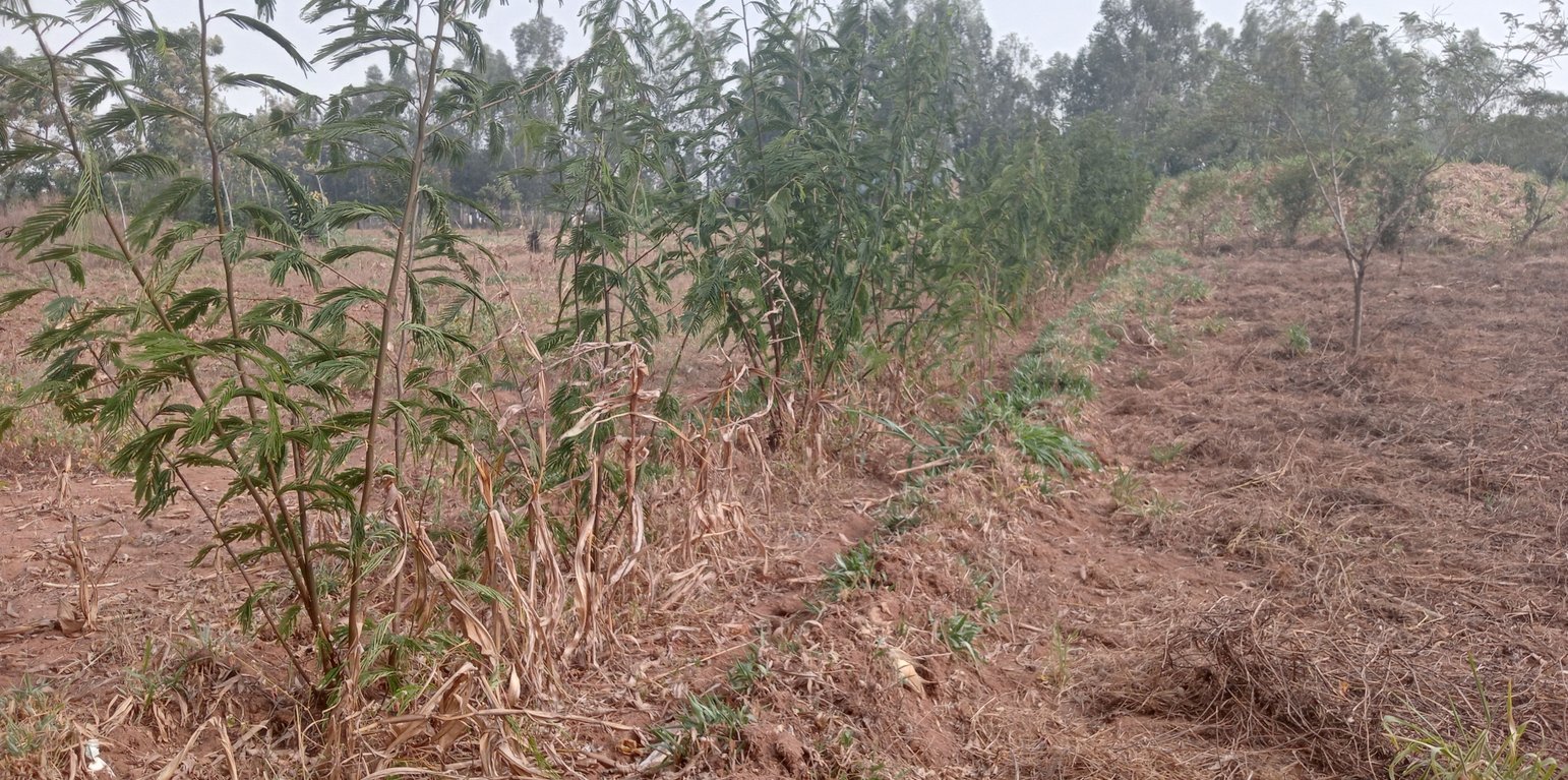
Calliandra incorporated into a vegetative cross-slope barrier (William Akwanyi)

Vegetative cross-slope barriers (Kenia)

Descripción

Cross-slope barriers in the form of vegetative strips are established on sloping lands to reduce runoff velocity and prevent soil loss, thereby contributing to the conservation of soil, water, and plant nutrients.

Vegetative cross-slope barriers are strips of perennial plants that are established along the contours of sloping lands. They act as soil and water conservation measures to reduce runoff velocity and consequently prevent soil loss. The strips are mostly between 0.3 m and 1.5 m wide and consist initially of one or two rows of plants. They slow down the speed of runoff during heavy rainfall. This facilitates infiltration, and eroded sediment in the runoff is trapped on the upslope side of the barriers. Hence, they contribute to the conservation of soil, water, and plant nutrients. The most used plants/ crops used in establishing vegetative cross-slope barriers are perennial erect grasses, including Brachiaria sp., napier grass (Pennisetum purpureum), and vetiver grass (Vetiver zizanioides). Depending on species (vetiver being an exception), vegetative cross-slope barriers can serve as important sources of fodder for livestock. Some farmers prefer to establish crops (e.g., bananas and pineapples) or trees and shrubs (e.g., (e.g., Calliandra calothyrus, Grevillea robusta or Sesbania sesban) as cross-slope barriers at appropriate spacing (depending on the tree/ shrub) to serve as windbreakers as well as providing additional measures to control soil erosion. Alternatively, these may be combined with grasses. These can also serve as important sources of food, fodder, fuel, and timber.

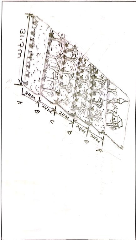
In establishing vegetative cross-slope barriers, the distance between the barriers is dictated by the slope of the land. The ProSoil project through Welthungerhilfe trained Community Resource Persons (CRPs) on how to survey contours using a line level. The CRPs by extension train farmers on how to measure slope for their fields and how to determine the distance between the barriers using a predetermined scale. Once established, minimal labour is required for maintenance. The main vegetation (grasses) must be harvested or cut back to a height of less than 0.5 m before planting a crop in the main field to prevent them from suppressing the crops through shading. The trees, and shrubs may need to be trimmed (coppiced) during the cropping period to allow adequate sunlight to reach the crops. The cut material can be collected and used as fodder or firewood as appropriate or be incorporated during land preparation, or during weeding as mulch.

Farmers like the technology because it contributes to soil, water, and nutrient conservation and it reduces the steepness of the slope as soil eroded from the upper part of the slope accumulates on the upslope side of the barrier resulting, eventually, in distinct terrace-like benches. As a result, farmers find it easier to cultivate on these terraces. Vegetative cross-slope barriers can be associated with retention ditches, especially where farmers find it important to harvest the water. They can also provide firewood and fodder, especially where palatable cut and carry varieties of grass are used.

Lugar

Lugar: Khalaba Ward, Matungu Sub-county in Kakamega County, Kakamega County in western Kenya, Kenia

No. de sitios de Tecnología analizados: un solo sitio

Georreferencia de sitios seleccionados
  • 34.54194, 0.41211

Difusión de la Tecnología: distribuida parejamente sobre un área (0.003804 km²)

¿En un área de protección permanente?: No

Fecha de la implementación: 2019

Tipo de introducción
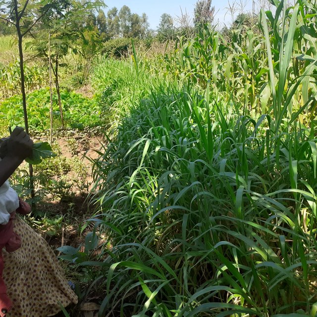
A vegetative cross-slope barrier (George Onyango)

Clasificación de la Tecnología

Propósito principal
  • mejorar la producción
  • reducir, prevenir, restaurar la degradación de la tierra
  • conservar el ecosistema
  • proteger una cuenca hidrográfica/ áreas corriente abajo – en combinación con otras Tecnologías
  • preservar/ mejorar biodiversidad
  • reducir el riesgo de desastres naturales
  • adaptarse al cambio climático/ extremos climáticos y sus impactos
  • mitigar cambio climático y sus impactos
  • crear impacto económico benéfico
  • crear impacto social benéfico
Uso de tierra
Mezcla de tipos de uso de tierras dentro de la misma unidad de tierras: Sí - Agroforestería

  • Tierras cultivadas
    • Cosecha anual: cultivos para forraje - otros, cultivos para forraje - pastos, cultivos para forraje - trébol, cultivos de semillas oleaginosas - maní, cereales - maíz, leguminosas y legumbres - frijoles, leguminosas y legumbres - soya, cultivos de raíces/ tubérculos - mandioca. Cropping system: Maíz/sorgo/ mijo en intercultivo con legumbres
    • Cultivos perennes (no leñosos)
    • Cosecha de árboles y arbustos: árboles para forraje (Calliandra, Leucaena leucocephala, Prosopis, etc.), avocado, frutas, otros, mango, mangostán, guayaba
    Número de temporadas de cultivo por año: 2
    ¿Se practica el intercultivo? Sí
    ¿Se practica la rotación de cultivos? Sí
  • Tierra de pastoreo
    • Cortar y llevar/ cero pastoreo
    • Pastoreo mejorado
    Tipo de animal: cattle - dairy and beef (e.g. zebu), aves de corral
    ¿Se practica el manejo integrado de cultivos - ganado? Sí
    Productos y servicios: economic security, investment prestige, leche, manure as fertilizer/ energy production, huevos, carne
      EspeciesConteo
      cattle - dairy and beef (e.g. zebu)3
      aves de corral10
    Provisión de agua
    • de secano
    • mixta de secano – irrigada
    • totalmente irrigada

    Propósito relacionado a la degradación de las tierras
    • prevenir la degradación de la tierra
    • reducir la degradación de la tierra
    • restaurar/ rehabilitar tierra severamente degradada
    • adaptarse a la degradación de la tierra
    • no aplica
    La degradación considerada
    • erosión de suelos por agua - Wt: pérdida de capa arable/ erosión de la superficie , Wg: erosión en cárcavas
    Grupo MST
    • agroforestería
    • manejo de agricultura—ganadería integrada
    • medida de pendiente transversal
    Medidas MST
    • medidas vegetativas - V1: Cubierta de árboles y arbustos , V2: Pastos y plantas herbáceas perennes

    Dibujo técnico

    Especificaciones técnicas
    Length of the farm (down the slope): 120 m
    Width of the farm (along the contour): 31.7 m
    Number of vegetative cross-slop barriers established: 6
    Width of barriers: ranges between 0.3 m and 0.5 m
    Slope: 4%
    Width of the established terraces/ distance between any two barriers: 24 m
    Plants used: brachiaria and napier grass (grasses), grevillea and calliandra (trees and shrub), bananas (crops)
    1st barrier on the upper side (F) is on a retention ditch
    Last barrier (A) is on the upper side of a channel that collects excess runoff and prevents damage to neighbours' farms on the lower side of the farm
    Author: William Akwanyi

    Establecimiento/ mantenimiento: actividades, insumos y costos

    Cálculo de insumos y costos
    • Los costos se calculan: por área de Tecnología (unidad de tamaño y área: 0.00761 ha; factor de conversión a una hectárea: 1 ha = 1 ha = 2.47 acres)
    • Moneda usada para calcular costos: KES
    • Tasa de cambio (a USD): 1 USD = 124.21352 KES
    • Costo promedio por día del sueldo de la mano de obra contratada: 250
    Factores más determinantes que afectan los costos
    Rate of man-days vary from one place to another and also depend on the kind of work. Exchange rate for January 2023, source: European Commission/ InfoEuro online at https://commission.europa.eu/funding-tenders/procedures-guidelines-tenders/information-contractors-and-beneficiaries/exchange-rate-inforeuro_en The stated costs are estimates.
    Actividades de establecimiento
    1. Contour surveying to establish locations for the vegetative cross slope barriers (Momento/ frequencia: Before planting)
    2. Planting (Momento/ frequencia: After rains)
    Costos totales de establecimiento (estimación)
    8000,0
    Actividades de mantenimiento
    1. Weeding (Momento/ frequencia: After every harvest)
    2. Adding manure/ compost (Momento/ frequencia: After every harvest)
    3. Regular inspection to fill large gaps in the barriers that are 30 Cm or more by replanting (Momento/ frequencia: Monthly during the rainy season)
    Insumos y costos de mantenimiento (per 0.00761 ha)
    Especifique insumo Unidad Cantidad Costos por unidad (KES) Costos totales por insumo (KES) % de los costos cubiertos por los usuarios de las tierras
    Mano de obra
    Weeding Man-days 3,0 250,0 750,0 100,0
    Adding manure/ compost Man-days 2,0 250,0 500,0 100,0
    Equipo
    Hoe (jembe) for weeding No. 1,0 90,0 90,0 100,0
    Wheelbarrow for carrying manure/ compost No. 1,0 500,0 500,0 100,0
    Spade for scooping manure/ wheelbarrow No. 1,0 100,0 100,0 100,0
    Fertilizantes y biocidas
    Manure/ compost Wheelbarrows 20,0 50,0 1000,0 100,0
    Indique los costos totales para mantenecer la Tecnología 2'940.0
    Costos totales para mantener la Tecnología en USD 23.67

    Entorno natural

    Promedio anual de lluvia
    • < 250 mm
    • 251-500 mm
    • 501-750 mm
    • 751-1,000 mm
    • 1,001-1,500 mm
    • 1,501-2,000 mm
    • 2,001-3,000 mm
    • 3,001-4,000 mm
    • > 4,000 mm
    Zona agroclimática
    • húmeda
    • Sub-húmeda
    • semi-árida
    • árida
    Especificaciones sobre el clima
    Promedio anual de lluvia en mm:1200.0
    Rainfall pattern is bimodal. Monthly rainfall variability is high with some months such as January recording less than 5 mm of total rainfall.
    Nombre de la estación meteorológica: Kakamega Meteorological Station
    Pendiente
    • plana (0-2 %)
    • ligera (3-5%)
    • moderada (6-10%)
    • ondulada (11-15%)
    • accidentada (16-30%)
    • empinada (31-60%)
    • muy empinada (>60%)
    Formaciones telúricas
    • meseta/ planicies
    • cordilleras
    • laderas montañosas
    • laderas de cerro
    • pies de monte
    • fondo del valle
    Altura
    • 0-100 m s.n.m.
    • 101-500 m s.n.m.
    • 501-1,000 m s.n.m
    • 1,001-1,500 m s.n.m
    • 1,501-2,000 m s.n.m
    • 2,001-2,500 m s.n.m
    • 2,501-3,000 m s.n.m
    • 3,001-4,000 m s.n.m
    • > 4,000 m s.n.m
    La Tecnología se aplica en
    • situaciones convexas
    • situaciones cóncavas
    • no relevante
    Profundidad promedio del suelo
    • muy superficial (0-20 cm)
    • superficial (21-50 cm)
    • moderadamente profunda (51-80 cm)
    • profunda (81-120 cm)
    • muy profunda (>120 cm)
    Textura del suelo (capa arable)
    • áspera/ ligera (arenosa)
    • mediana (limosa)
    • fina/ pesada (arcilla)
    Textura del suelo (> 20 cm debajo de la superficie)
    • áspera/ ligera (arenosa)
    • mediana (limosa)
    • fina/ pesada (arcilla)
    Materia orgánica de capa arable
    • elevada (>3%)
    • media (1-3%)
    • baja (<1%)
    Agua subterránea
    • en superficie
    • < 5 m
    • 5-50 m
    • > 50 m
    Disponibilidad de aguas superficiales
    • excesiva
    • bueno
    • mediana
    • pobre/ ninguna
    Calidad de agua (sin tratar)
    • agua potable de buena calidad
    • agua potable de mala calidad (requiere tratamiento)
    • solo para uso agrícola (irrigación)
    • inutilizable
    La calidad de agua se refiere a: agua subterránea y superficial
    ¿La salinidad del agua es un problema?
    • No

    Incidencia de inundaciones
    • No
    Diversidad de especies
    • elevada
    • mediana
    • baja
    Diversidad de hábitats
    • elevada
    • mediana
    • baja

    Las características de los usuarios de la tierra que aplican la Tecnología

    Orientación del mercado
    • subsistencia (autoprovisionamiento)
    • mixta (subsistencia/ comercial)
    • comercial/ mercado
    Ingresos no agrarios
    • menos del 10% de todos los ingresos
    • 10-50% de todo el ingreso
    • > 50% de todo el ingreso
    Nivel relativo de riqueza
    • muy pobre
    • pobre
    • promedio
    • rico
    • muy rico
    Nivel de mecanización
    • trabajo manual
    • tracción animal
    • mecanizado/motorizado
    Sedentario o nómada
    • Sedentario
    • Semi-nómada
    • Nómada
    Individuos o grupos
    • individual/ doméstico
    • grupos/ comunal
    • cooperativa
    • empleado (compañía, gobierno)
    Género
    • mujeres
    • hombres
    Edad
    • niños
    • jóvenes
    • personas de mediana edad
    • ancianos
    Área usada por hogar
    • < 0.5 ha
    • 0.5-1 ha
    • 1-2 ha
    • 2-5 ha
    • 5-15 ha
    • 15-50 ha
    • 50-100 ha
    • 100-500 ha
    • 500-1,000 ha
    • 1,000-10,000 ha
    • > 10,000 ha
    Escala
    • pequeña escala
    • escala mediana
    • gran escala
    Tenencia de tierra
    • estado
    • compañía
    • comunitaria/ aldea
    • grupal
    • individual, sin título
    • individual, con título
    Derechos de uso de tierra
    • acceso abierto (no organizado)
    • comunitarios (organizado)
    • arrendamiento
    • individual
    Derechos de uso de agua
    • acceso abierto (no organizado)
    • comunitarios (organizado)
    • arrendamiento
    • individual
    Acceso a servicios e infraestructura
    salud

    pobre
    x
    bueno
    educación

    pobre
    x
    bueno
    asistencia técnica

    pobre
    x
    bueno
    empleo (ej. fuera de la granja)

    pobre
    x
    bueno
    mercados

    pobre
    x
    bueno
    energía

    pobre
    x
    bueno
    caminos y transporte

    pobre
    x
    bueno
    agua potable y saneamiento

    pobre
    x
    bueno
    servicios financieros

    pobre
    x
    bueno

    Impacto

    Impactos socioeconómicos
    Producción de cultivo
    disminuyó
    x
    incrementó

    Cantidad antes de MST: 2
    Cantidad luego de MST: 6
    Quantity refers to the number of 90 Kg bags of maize produced per acre. Although vegetative cross-slope barriers reduced the available space for crops, other SLM technologies such as retention ditches and the use of compost contributed to the increase in the production. According to the farmer, the soil at the farm was highly eroded before the SLM technologies were introduced.

    calidad de cultivo
    disminuyó
    x
    incrementó


    Not easy to quantify but according to the farmer, the crops are doing better compared to how they were before the cross-slope barriers were established.

    producción de forraje
    disminuyó
    x
    incrementó


    the farmer estimates that the amount of napier grass harvested from the farm within a year has increased. Farmer not able to quantify.

    calidad de forraje
    disminuyó
    x
    incrementó


    Not easy to quantify but according to the farmer, napier grass is doing better compared to how it was before the cross-slope barriers were established.

    producción animal
    disminuyó
    x
    incrementó

    Cantidad antes de MST: 4
    Cantidad luego de MST: 7
    Amount of milk produced by one cow during early lactation period.

    manejo de tierras
    obstaculizado
    x
    simplificado


    Easy of working on less eroded soils. A farmer's estimate.

    gastos en insumos agrícolas
    incrementó
    x
    disminuyó

    Cantidad antes de MST: 5000
    Cantidad luego de MST: 0
    Expenditure on fertilizer in KES. The farmer no longer uses fertilizer.

    ingreso agrario
    disminuyó
    x
    incrementó

    Cantidad antes de MST: 0
    Cantidad luego de MST: 6000
    The farmer earns income from selling napier grass - per year. This is based on the farmer's estimate.

    diversidad de fuentes de ingreso
    disminuyó
    x
    incrementó


    The farmer considers the money earned from selling napier grass as an extra source of income.

    Impactos socioculturales
    seguridad alimentaria/ autosuficiencia
    disminuyó
    x
    mejoró

    Cantidad antes de MST: 2
    Cantidad luego de MST: 0.5
    Number of months in a year when there is total lack of food in the house, and the farmer has to buy all the food required in the house. Based on the farmer's estimate.

    MST/ conocimiento de la degradación de la tierra
    disminuyó
    x
    mejoró


    Level of knowledge in SLM/ land management. This is a farmer's estimate that she has increased her knowledge in SLM.

    Impactos ecológicos
    escurrimiento superficial
    incrementó
    x
    disminuyó


    The farmer notes that the amount of water leaving the farm and silting other farms in the lower areas. has greatly reduced.

    pérdida de suelo
    incrementó
    x
    disminuyó


    the farmer notes that the amount of silt deposited in the lower parts of the farm and in other farms on the lower side of the farm has reduced.

    acumulación de suelo
    disminuyó
    x
    incrementó


    the farmer notes that the amount of soil trapped by the vegetative cross slope barriers is high and this leads to an increase in soil accummulation at the farm.

    Impactos fuera del sitio
    daño a campos de vecinos
    incrementó
    x
    disminuyó


    Amount of runoff leaving the farm with potential to cause soil erosion in neighbouring farms.

    Análisis costo-beneficio

    Beneficios comparados con los costos de establecimiento
    Ingresos a corto plazo:
    muy negativo
    x
    muy positivo

    Ingresos a largo plazo
    muy negativo
    x
    muy positivo

    Beneficios comparados con costos de mantenimiento
    Ingresos a corto plazo:
    muy negativo
    x
    muy positivo

    Ingresos a largo plazo
    muy negativo
    x
    muy positivo

    Cambio climático

    Cambio climático gradual
    temperatura anual incrementó

    nada bien
    x
    muy bien
    temperatura estacional incrementó

    nada bien
    x
    muy bien
    Estación: estación seca
    Extremos (desastres) relacionados al clima
    tormenta de lluvia local

    nada bien
    x
    muy bien

    Adopción y adaptación

    Porcentaje de usuarios de la tierra que adoptaron la Tecnología
    • casos individuales / experimentales
    • 1-10%
    • 11-50%
    • > 50%
    De todos quienes adoptaron la Tecnología, ¿cuántos lo hicieron sin recibir incentivos/ pagos materiales?
    • 0-10%
    • 11-50%
    • 51-90%
    • 91-100%
    ¿La tecnología fue modificada recientemente para adaptarse a las condiciones cambiantes?
    • No
    ¿A qué condiciones cambiantes?
    • cambios climáticos / extremos
    • mercados cambiantes
    • disponibilidad de mano de obra (ej. debido a migración)

    Conclusiones y lecciones aprendidas

    Fortalezas: perspectiva del usuario de tierras
    • Soil erosion control.
    • increased yields.
    Fortalezas: punto de vista del compilador o de otra persona recurso clave
    • More benefits, including firewood and other products from trees planted on the cross slope barriers.
    Debilidades/ desventajas/ riesgos: perspectiva del usuario de tierrascómo sobreponerse
    Debilidades/ desventajas/ riesgos: punto de vista del compilador o de otra persona recurso clavecómo sobreponerse
    • Reduces area meant for crop production. Ensure optimum use of manure to offset production loss.

    Referencias

    Compilador
    • William Akwanyi
    Editors
    • George Onyango
    • Innocent Faith
    • Noel Templer
    • Tabitha Nekesa
    • Ahmadou Gaye
    • Siagbé Golli
    Revisado por
    • William Critchley
    • Rima Mekdaschi Studer
    • Sally Bunning
    Fecha de la implementación: 19 de marzo de 2023
    Últimas actualización: 23 de abril de 2024
    Personas de referencia
    Descripción completa en la base de datos de WOCAT
    Datos MST vinculados
    La documentación fue facilitada por
    Institución Proyecto
    Vínculos a la información relevante disponible en línea
    This work is licensed under Creative Commons Attribution-NonCommercial-ShareaAlike 4.0 International