Contour Stone Bunds (Tshering Yangzom)

Contour Stone Bunds (Bután)

Dhoyi Gaytshig (རྡོའི་རྒད་ཚིག།)

Descripción

Contour stone bunding on sloping agricultural lands reduces soil erosion and conserves soil moisture in order to retain soil productivity. It is promoted /recommended on slopes where there is adequate surface stone.

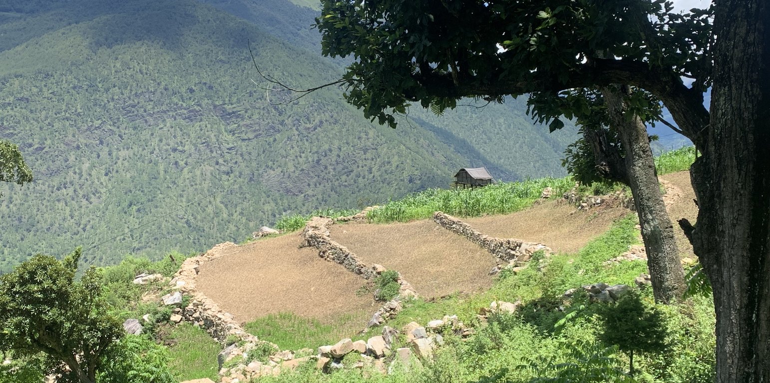
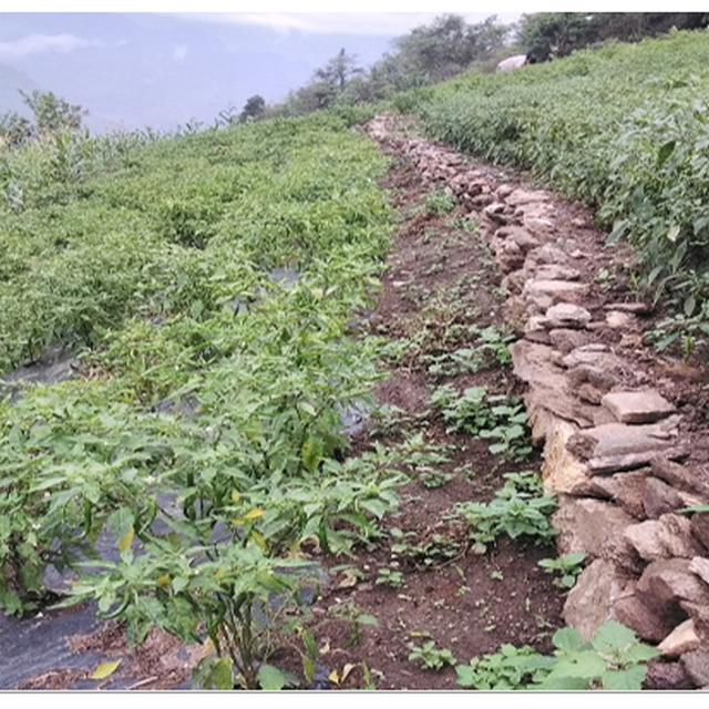
Contour stone bunds are small walls of stone that are laid out along the contour line to help reduce soil erosion, conserve soil moisture, increase soil fertility, to ease workability, increase cropping area, and ultimately ensure sustainable use of lands for enhanced food and nutrition security. This practice is recommended in fields that have plenty of surface stones (> 20%). Construction of contour stone bunds not only helps to get rid of the excess surface stones and gravel but also reduces the slope gradient through formation of partial terraces over a few years.
The stone bund is not new to Bhutan, being a mountainous country, forefathers used the technique to remove stones from the field and stabilise the land for agricultural purposes. Therefore, there were some traditional stone lines constructed in the study area.
Constructing stone bund is labour intensive, therefore land users resort to a labour sharing approach where all the land users from the community come together and work on a rotational basis until every household in the community has established stone bunds.
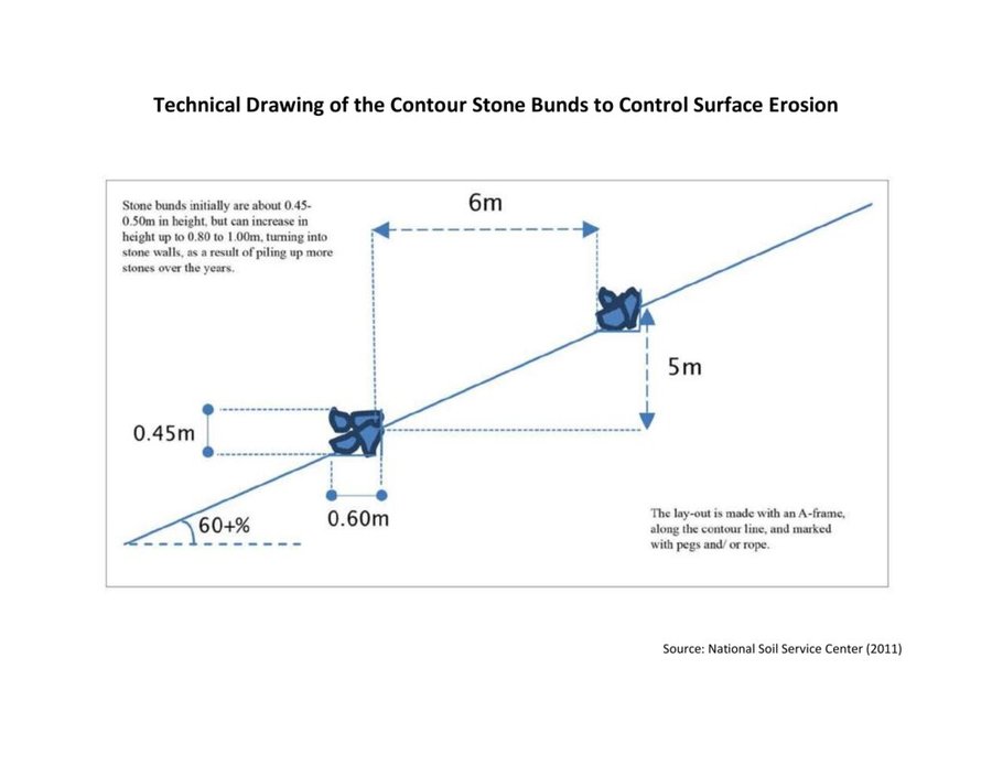
The major activities and inputs required to establish the contour stone bund includes sensitization of beneficiaries, followed by SLM action planning, and hands-on-training. Field implementation follows this sequence: (a) determination of intervals between stone bunds, (b) demarcation of contour lines using an ‘A’ frame, (c) digging a trench of 0.1 - 0.2 m deep and 0.5 m wide to establish a foundation along the contour lines, and (d) constructing stone lines along the trenches with the larger stones at the base to set a sound foundation. A typical stone wall is 0.3 m high (1 ft) and 0.3 - 0.5 m wide, but this depends on the slope and availability of stones in the field. Contour stone bunds are commonly spaced 6 metres apart on slopes of 60%. In some cases, the fodder grass slips are also planted at the base of the stone bund for better stabilization of the bunds and fodder availability.
The major drawbacks of this SLM technology according to respondents are (a) labour demanding, (b) no immediate return, and (c) the space between piled stones harbours rodents leading to crop damage.

Lugar

Lugar: Zangkhar Village, Yabi-Zangkhar Chiwog, Jaray Gewog, Lhuentse Dzongkhag, Bután

No. de sitios de Tecnología analizados: 2-10 sitios

Georreferencia de sitios seleccionados
  • 91.15742, 27.50286

Difusión de la Tecnología: distribuida parejamente sobre un área (approx. 0.1-1 km2)

¿En un área de protección permanente?:

Fecha de la implementación: 2015

Tipo de introducción
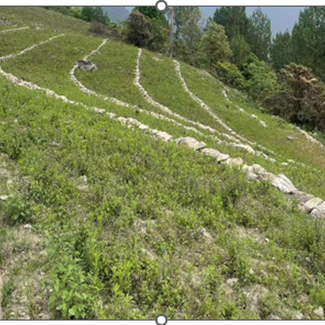
Stone bunds constructed along the contour line in agriculture dryland. (Haka Drukpa)
Leaving no stones unturned. (Haka Drukpa)

Clasificación de la Tecnología

Propósito principal
  • mejorar la producción
  • reducir, prevenir, restaurar la degradación de la tierra
  • conservar el ecosistema
  • proteger una cuenca hidrográfica/ áreas corriente abajo – en combinación con otras Tecnologías
  • preservar/ mejorar biodiversidad
  • reducir el riesgo de desastres naturales
  • adaptarse al cambio climático/ extremos climáticos y sus impactos
  • mitigar cambio climático y sus impactos
  • crear impacto económico benéfico
  • crear impacto social benéfico
Uso de tierra
Mezcla de tipos de uso de tierras dentro de la misma unidad de tierras: Sí - Agroforestería

  • Tierras cultivadas
    • Cosecha anual: cultivos de raíces/ tubérculos - patatas, vegetales - verdura de hojas verdes (ensaladas, repollo, espinaca, otros), Chili, cauliflower, cabbage, onion, brinjal and garlic.
    • Cultivos perennes (no leñosos)
    Número de temporadas de cultivo por año: 2
    ¿Se practica el intercultivo? Sí
    ¿Se practica la rotación de cultivos? Sí
  • asentamientos, infraestructura - Asentamientos, edificios, Tráfico: caminos, rieles, Energía: gasoductos, líneas eléctricas

Provisión de agua
  • de secano
  • mixta de secano – irrigada
  • totalmente irrigada

Propósito relacionado a la degradación de las tierras
  • prevenir la degradación de la tierra
  • reducir la degradación de la tierra
  • restaurar/ rehabilitar tierra severamente degradada
  • adaptarse a la degradación de la tierra
  • no aplica
La degradación considerada
  • erosión de suelos por agua - Wt: pérdida de capa arable/ erosión de la superficie , Wg: erosión en cárcavas, Wo: efectos de degradación fuera del sitio
  • degradación biológica - Bc: reducción de la cobertura vegetal del suelo , Bq: reducción de la cantidad/ biomasa, Bs: reducción en la calidad y composición/ diversidad de las especies, Bp: incremento de pestes/ enfermedades, pérdida de depredadores
  • degradación del agua - Ha: aridificación
Grupo MST
  • medida de pendiente transversal
Medidas MST
  • medidas vegetativas - V2: Pastos y plantas herbáceas perennes
  • medidas estructurales - S2: Taludes, bancos

Dibujo técnico

Especificaciones técnicas
The specifications provided in the technical drawing (NSSC, 2011) may vary based on the field situation and slope of the land. Variations may be in the width of the terrace (3 m to 6 m), the height of the stone bund (0.45 m to 1m), and minimal variations are observed in the width of the stone bund (0.6 m).
Author: National Soil Service Centre

Establecimiento/ mantenimiento: actividades, insumos y costos

Cálculo de insumos y costos
  • Los costos se calculan: por área de Tecnología (unidad de tamaño y área: 3 acres)
  • Moneda usada para calcular costos: Nu
  • Tasa de cambio (a USD): 1 USD = 80.0 Nu
  • Costo promedio por día del sueldo de la mano de obra contratada: 400
Factores más determinantes que afectan los costos
The most important factor affecting the cost is labor.
Actividades de establecimiento
  1. Traditional stone bund construction (Momento/ frequencia: 50 years earlier)
  2. Sensitization, SLM action planning, and Hands-on-training (Momento/ frequencia: 2015)
  3. Field implementation of the activity (Momento/ frequencia: 2015)
  4. Provision of incentives (Nu. 3000 per acre) (Momento/ frequencia: 2015)
  5. Project phase-off (Momento/ frequencia: 2017)
  6. Scaling up of this technology through GEF-LDCF (Momento/ frequencia: 2022)
Insumos y costos para establecimiento (per 3 acres)
Especifique insumo Unidad Cantidad Costos por unidad (Nu) Costos totales por insumo (Nu) % de los costos cubiertos por los usuarios de las tierras
Mano de obra
Labour Person/day 49,0 400,0 19600,0 100,0
Otros
Project incentive Per hectare 1,0 6420,0 6420,0
Costos totales para establecer la Tecnología 26'020.0
Costos totales para establecer la Tecnología en USD 325.25
Actividades de mantenimiento
n.a.

Entorno natural

Promedio anual de lluvia
  • < 250 mm
  • 251-500 mm
  • 501-750 mm
  • 751-1,000 mm
  • 1,001-1,500 mm
  • 1,501-2,000 mm
  • 2,001-3,000 mm
  • 3,001-4,000 mm
  • > 4,000 mm
Zona agroclimática
  • húmeda
  • Sub-húmeda
  • semi-árida
  • árida
Especificaciones sobre el clima
Promedio anual de lluvia en mm:1250.0
The rainfall received in the region may vary from 1000 to 1500 mm.
The rainfall data of the Gewog is not available. The area shares a border with the Medtsho Gewog and has similar agroecological zones. The data provided is for Medtsho Gewog.
Nombre de la estación meteorológica: Website, Lhuentse Dzongkhag Administration
The Gewog falls under dry sub-tropical to warm temperate region (1500 to 2400 meters above sea level) from the six agroecological zones of Bhutan. It is characterized by extreme cold in winter and moderate in summer, humid and foggy.
Pendiente
  • plana (0-2 %)
  • ligera (3-5%)
  • moderada (6-10%)
  • ondulada (11-15%)
  • accidentada (16-30%)
  • empinada (31-60%)
  • muy empinada (>60%)
Formaciones telúricas
  • meseta/ planicies
  • cordilleras
  • laderas montañosas
  • laderas de cerro
  • pies de monte
  • fondo del valle
Altura
  • 0-100 m s.n.m.
  • 101-500 m s.n.m.
  • 501-1,000 m s.n.m
  • 1,001-1,500 m s.n.m
  • 1,501-2,000 m s.n.m
  • 2,001-2,500 m s.n.m
  • 2,501-3,000 m s.n.m
  • 3,001-4,000 m s.n.m
  • > 4,000 m s.n.m
La Tecnología se aplica en
  • situaciones convexas
  • situaciones cóncavas
  • no relevante
Profundidad promedio del suelo
  • muy superficial (0-20 cm)
  • superficial (21-50 cm)
  • moderadamente profunda (51-80 cm)
  • profunda (81-120 cm)
  • muy profunda (>120 cm)
Textura del suelo (capa arable)
  • áspera/ ligera (arenosa)
  • mediana (limosa)
  • fina/ pesada (arcilla)
Textura del suelo (> 20 cm debajo de la superficie)
  • áspera/ ligera (arenosa)
  • mediana (limosa)
  • fina/ pesada (arcilla)
Materia orgánica de capa arable
  • elevada (>3%)
  • media (1-3%)
  • baja (<1%)
Agua subterránea
  • en superficie
  • < 5 m
  • 5-50 m
  • > 50 m
Disponibilidad de aguas superficiales
  • excesiva
  • bueno
  • mediana
  • pobre/ ninguna
Calidad de agua (sin tratar)
  • agua potable de buena calidad
  • agua potable de mala calidad (requiere tratamiento)
  • solo para uso agrícola (irrigación)
  • inutilizable
La calidad de agua se refiere a: agua subterránea
¿La salinidad del agua es un problema?
  • No

Incidencia de inundaciones
  • No
Diversidad de especies
  • elevada
  • mediana
  • baja
Diversidad de hábitats
  • elevada
  • mediana
  • baja

Las características de los usuarios de la tierra que aplican la Tecnología

Orientación del mercado
  • subsistencia (autoprovisionamiento)
  • mixta (subsistencia/ comercial)
  • comercial/ mercado
Ingresos no agrarios
  • menos del 10% de todos los ingresos
  • 10-50% de todo el ingreso
  • > 50% de todo el ingreso
Nivel relativo de riqueza
  • muy pobre
  • pobre
  • promedio
  • rico
  • muy rico
Nivel de mecanización
  • trabajo manual
  • tracción animal
  • mecanizado/motorizado
Sedentario o nómada
  • Sedentario
  • Semi-nómada
  • Nómada
Individuos o grupos
  • individual/ doméstico
  • grupos/ comunal
  • cooperativa
  • empleado (compañía, gobierno)
Género
  • mujeres
  • hombres
Edad
  • niños
  • jóvenes
  • personas de mediana edad
  • ancianos
Área usada por hogar
  • < 0.5 ha
  • 0.5-1 ha
  • 1-2 ha
  • 2-5 ha
  • 5-15 ha
  • 15-50 ha
  • 50-100 ha
  • 100-500 ha
  • 500-1,000 ha
  • 1,000-10,000 ha
  • > 10,000 ha
Escala
  • pequeña escala
  • escala mediana
  • gran escala
Tenencia de tierra
  • estado
  • compañía
  • comunitaria/ aldea
  • grupal
  • individual, sin título
  • individual, con título
  • Family
Derechos de uso de tierra
  • acceso abierto (no organizado)
  • comunitarios (organizado)
  • arrendamiento
  • individual
Derechos de uso de agua
  • acceso abierto (no organizado)
  • comunitarios (organizado)
  • arrendamiento
  • individual
Acceso a servicios e infraestructura
salud

pobre
bueno
educación

pobre
bueno
asistencia técnica

pobre
bueno
empleo (ej. fuera de la granja)

pobre
bueno
mercados

pobre
bueno
energía

pobre
bueno
caminos y transporte

pobre
bueno
agua potable y saneamiento

pobre
bueno
servicios financieros

pobre
bueno

Impacto

Impactos socioeconómicos
Producción de cultivo
disminuyó
incrementó


The cultivation of potatoes increased due to an increase in the cultivable area as the stones are removed.

calidad de cultivo
disminuyó
incrementó


Crops appear greener and healthier due prevention of soil erosion as the topsoil is retained. Maize leaves were dark green and potatoes were bigger.

riesgo de fracaso de producción
incrementó
disminuyó


Due to the removal of stones from the soil, it is suitable for diverse crop growth (deep-rooted and shallow). Therefore, the land user can cultivate diverse crops throughout the year. Crop diversity and increased growing season will ensure land user with stable household income even if one crop fails.

diversidad de producto
disminuyó
incrementó


The technology reduces workload (mechanization) and increases cultivable area leading to the cultivation of diverse crops for market purposes.

área de producción (nuevas tierras bajo cultivo/ en uso)
disminuyó
incrementó


Increased due to the removal of stones from the land.

gastos en insumos agrícolas
incrementó
disminuyó


Expenses on agriculture input are reduced. For example, with the use of a power tiller which costs Nu. 1500 per day, it takes 2 days to complete ploughing. If it is done by oxen then it takes 8 days and Nu. 400 is paid as a labour charge per day. The total amount required using the power tiller is Nu. 3000 and using oxen is Nu. 3200 with an additional cost of food for the labourers.

ingreso agrario
disminuyó
incrementó


Previously the land user was not able to meet the demand for maize as a feed for the cattle. With the introduction of stone bunding and increased production, the land user can meet her domestic demand for maize and additionally sell processed maize alcohol as a source of farm income.

diversidad de fuentes de ingreso
disminuyó
incrementó


There is an increased diversity of income sources as the land user can grow different crops throughout the year and also sell some processed products.

carga de trabajo
incrementó
disminuyó


Reduced work load due to farm mechanization. The removal of stone from field had eased workability, lesser wear and tear of farm tools.

Impactos socioculturales
seguridad alimentaria/ autosuficiencia
disminuyó
mejoró


With the increase in cultivable areas, technology has ensured food self-sufficiency and generated income to meet other household demands for food.

oportunidades recreativas
disminuyó
mejoró


Reduced workload is directly related to an increase in the available time for recreational opportunities.

instituciones nacionales
se debilitaron
se fortalecieron


Support provided by the NSSC and land users' active participation in the implementation of the technology enabled the national agency to have a better understanding of the land users. Labour sharing enabled the community to work together to achieve a common goal which improved collaboration among the community members.

MST/ conocimiento de la degradación de la tierra
disminuyó
mejoró


Awareness was created during the introduction of the technology by SLM specialists. Further, the field observation on the neighbours' fields who have already established stone bunds has led to 90% of the population knowing about the stone bunding in the locality.

mitigación de conflicto
empeoró
mejoró


Human-wildlife conflict was reduced as wild boars were not able to climb the stone bund. Although other wild animal such as procupine continued to cause harm to the crop.

situación de grupos en desventaja social y económica (género, etáreo, estatus, etnicidad, etc.)
empeoró
mejoró


The technology improved soil quality leading to improved production and increased household income.

Impactos ecológicos
humedad del suelo
disminuyó
incrementó


The stone bund holds irrigation water preventing surface runoff. Further, the gradual labelling of the land increases soil moisture retention capacity.

cubierta del suelo
disminuyó
mejoró


Increased due to crop diversification and year-round cultivation.

pérdida de suelo
incrementó
disminuyó


Soil erosion and surface runoff is reduced leading to decreased soil loss.

acumulación de suelo
disminuyó
incrementó


Eroded soil is accumulated at bunds.

materia orgánica debajo del suelo C
disminuyó
incrementó


Soil organic matter is decreased at the upper part of the terrace and increased at the lower part of the terrace due to runoff from the slopes.

cubierta vegetal
disminuyó
incrementó


Increased with the practice of year-round cultivation.

diversidad vegetal
disminuyó
incrementó


The technology increased suitability of the soil for diverse crops increasing plant diversity.

control de pestes/ enfermedades
disminuyó
incrementó


The better crop stand resists pest and diseases attacks on crops. To some extend, the stone bunds keep the wild boars away.

deslizamientos/ fluyos de escombros
incrementó
disminuyó


Reduced surface runoff leads to decreased landslides or debris flow.

Impactos fuera del sitio

Análisis costo-beneficio

Beneficios comparados con los costos de establecimiento
Ingresos a corto plazo:
muy negativo
muy positivo

Ingresos a largo plazo
muy negativo
muy positivo

Beneficios comparados con costos de mantenimiento
Ingresos a corto plazo:
muy negativo
muy positivo

Ingresos a largo plazo
muy negativo
muy positivo

The benefits compared with the establishment costs for the short term are positive due to the subsidy provided.

Cambio climático

Cambio climático gradual
lluvia anual incrementó

nada bien
muy bien

Adopción y adaptación

Porcentaje de usuarios de la tierra que adoptaron la Tecnología
  • casos individuales / experimentales
  • 1-10%
  • 11-50%
  • > 50%
De todos quienes adoptaron la Tecnología, ¿cuántos lo hicieron sin recibir incentivos/ pagos materiales?
  • 0-10%
  • 11-50%
  • 51-90%
  • 91-100%
Número de hogares y/ o área cubierta
Total of 33 households adopted stone bunds technology.
¿La tecnología fue modificada recientemente para adaptarse a las condiciones cambiantes?
  • No
¿A qué condiciones cambiantes?
  • cambios climáticos / extremos
  • mercados cambiantes
  • disponibilidad de mano de obra (ej. debido a migración)

Conclusiones y lecciones aprendidas

Fortalezas: perspectiva del usuario de tierras
  • Sloping land is challenged by soil erosion and it has a poor ability to retain water. This challenge was alleviated by stone bunding as it significantly reduced soil degradation.
  • The land user shared that there is an increased cultivable area after the implementation of the technology. Bigger stones were excavated and piled as stone bunds increasing the total area for cultivation.
  • The technology eased farming, as agronomic practices such as tilling became efficient due to the use of power tillers. Soil depth was increased leading to ease in weeding, bed making and other management practices.
  • Stone walls prevented wild boar from entering the field reducing crop loss. Therefore, the farmers need not guard the field from wild boar.
  • Increased cultivable area and easy working conditions of the soil lead to increased production, and improved livelihood of the farm household.
Fortalezas: punto de vista del compilador o de otra persona recurso clave
  • The technology contributed to reducing rural-urban migration and generated employment. Stone bunding indirectly helped the farming community to engage in agricultural activities and stay back in the village rather than going out to the city in search of employment.
  • Prevent natural disasters. The Gewog is located in the steep slopes and there is a risk of landslides leading to loss of agricultural land, property, and life. Stone bunding prevents surface runoff which could aggravate and lead to land slides.
  • Once the stone and boulders are removed and piled along contour line, it improves workability on the farm.
Debilidades/ desventajas/ riesgos: perspectiva del usuario de tierrascómo sobreponerse
  • Construction of stone bunds is a laboursome and has no direct benefit to the land users. Practice labour sharing working modality.
  • If stone bunds were not constructed properly, it could be easily damaged by cattle, washed or collapsed by heavy rainfall. Proper piling of stones during the stone bund construction.
Debilidades/ desventajas/ riesgos: punto de vista del compilador o de otra persona recurso clavecómo sobreponerse
  • Some sort of incentives is required to scale out the adoption of technology as its requires huge labour and time with no immediate benefits. Incentive of Nu 3000 tied with construction of 1 ac of stone bunds

Referencias

Compilador
  • Nima Dolma Tamang
Editors
  • Kuenzang Nima
Revisado por
  • William Critchley
  • Rima Mekdaschi Studer
  • Joana Eichenberger
Fecha de la implementación: 19 de agosto de 2023
Últimas actualización: 4 de junio de 2024
Personas de referencia
Descripción completa en la base de datos de WOCAT
Datos MST vinculados
La documentación fue facilitada por
Institución Proyecto
Referencias claves
  • NSSC. (2011). Bhutan catalogue of soil and water conservation approaches and technologies. National Soil Service Center (NSSC), Department of Agriculture, Ministry of Agriculture and Forests, Royal Government of Bhutan, Thimphu: Book and soft copy from https://www.wocat.net/documents/140/Bhutan_catalogue_of_SLM_Technologies_and_Approaches.pdf
Vínculos a la información relevante disponible en línea
This work is licensed under Creative Commons Attribution-NonCommercial-ShareaAlike 4.0 International