'Forage Christine' [Burkina Faso]
- Creación:
- Actualización:
- Compilador: Nouhoun Zampaligré
- Editor: –
- Revisores: Rima Mekdaschi Studer, Simone Verzandvoort, Donia Mühlematter
Forage Christine
technologies_2994 - Burkina Faso
Visualizar secciones
Expandir todo Colapsar todos1. Información general
1.2 Detalles de contacto de las personas de referencia e instituciones involucradas en la evaluación y la documentación de la Tecnología
Nombre del proyecto que financió la documentación/ evaluación de la Tecnología (si fuera relevante)
Book project: Guidelines to Rangeland Management in Sub-Saharan Africa (Rangeland Management)Nombre de la(s) institución(es) que facilitaron la documentación/ evaluación de la Tecnología (si fuera relevante)
INERA Institut de l'environnement et de recherches agricoles (INERA Institut de l'environnement et de recherches agricoles) - Burkina Faso1.3 Condiciones referidas al uso de datos documentados mediante WOCAT
¿Cuándo se compilaron los datos (en el campo)?
01/06/2017
El compilador y la/s persona(s) de referencia claves aceptan las condiciones acerca del uso de los datos documentados mediante WOCAT:
Sí
1.4 Declaración de la sostenibilidad de la Tecnología descrita
¿La Tecnología aquí descrita resulta problemática en relación a la degradación de la tierra, de tal forma que no puede considerársela una tecnología sostenible para el manejo de la tierra?
No
2. Descripción de la Tecnología MST
2.1 Breve descripción de la Tecnología
Definición de la Tecnología:
A modern hydraulic complex in the centre of the Sahelian region of Burkina Faso for watering livestock in the dry season.
2.2 Descripción detallada de la Tecnología
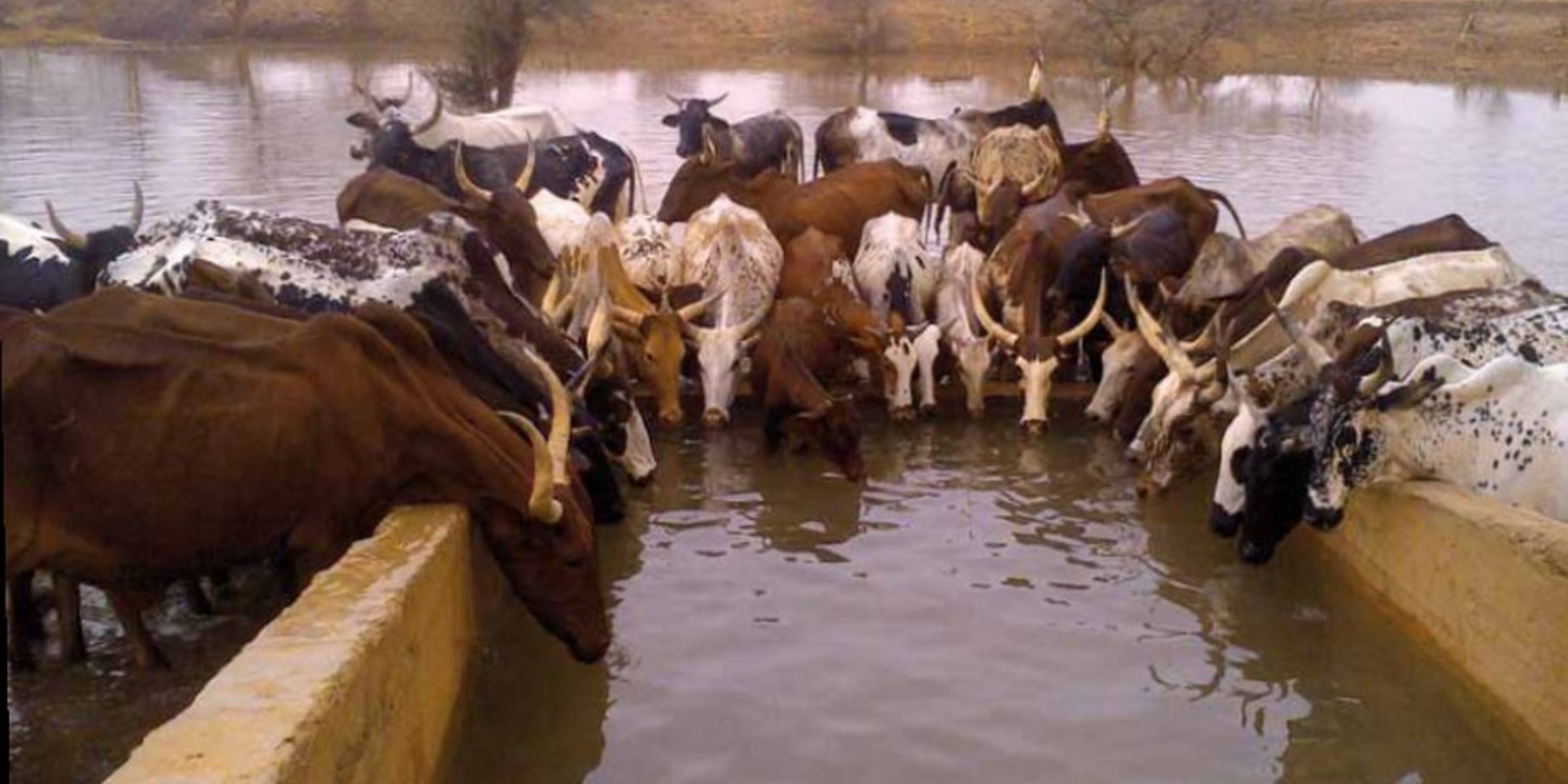
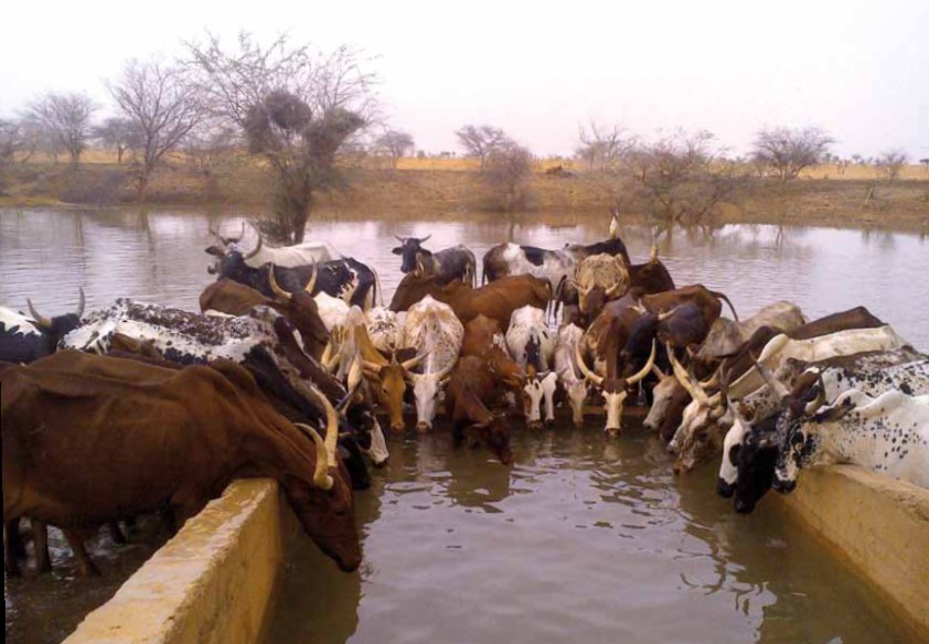
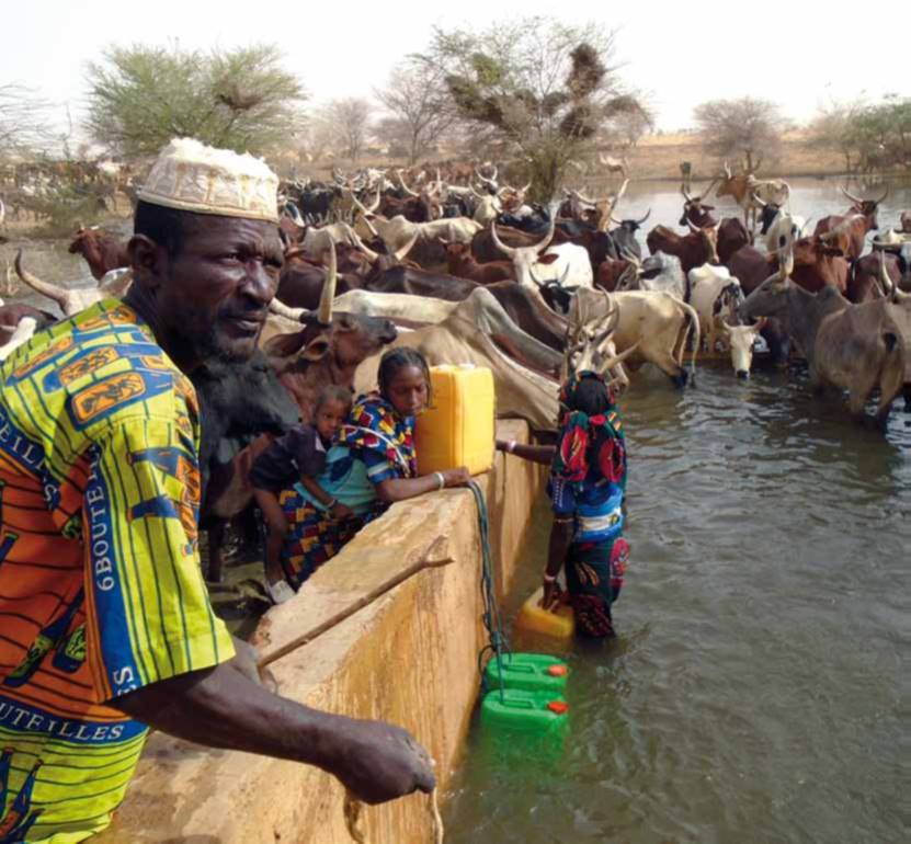
Descripción:
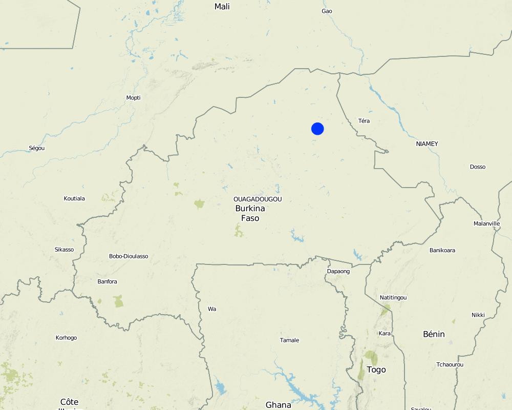
'Forage Christine' is a major water infrastructure, established in the northern part of the Sahel region in Burkina Faso between longitude 0°45’W and latitude 14°48’N, providing drinking water to herds within an area of 100 to 300 km from its central location between Burkina Faso, Mali and Niger. It was established in 1971 in the context of major droughts that had affected the Sahel, and it was opened for the first time in 1972. It is located in the middle of the Sahel region of Burkina Faso, at two km from the pond of Tin-Arkachen in the department of Déou, at approximately 45 km from the capital of the department, and 85 km from Gorom-Gorom. At the sub-regional level, the well is a around ten km from the border with Mali, and at 100 km from the border with Niger. The climate is of Sahelian type, and has a rainy season of 3 to 4 months (from June-July to September), which is subject to strong temporal and spatial variations in precipitation, and a dry season of 8 to 9 months. The climatic conditions are characterized by highly irregular winds, precipitation, evapotranspiration and moisture due to fluctuations in atmospheric circulation patterns. Annual precipitation is around 500 mm on average, with roughly 30 rainy days, and is marked by significant inter-annual variations. The stream network of the region consists of several streams, with one permanent river: Béli. To this river, ponds and many depressions are connected, which disappear after the month of January. The soils are very diverse in general, and mostly of sandy texture. They do not provide a good medium for plant growth due to the low permeability, which reduces water infiltration. Therefore water availability appears to be one of the major limitations for rainfed agriculture, in addition to the limited retention and availability of nutrients. According to the phytogeographic division of Burkina Faso (Fontes and Guinko, 1995), the area of 'Forage Christine' is situated in the northern or strict Sahelian phytogeographic sector. This sector is characterized by a set of typical Saharan and Sahelian vegetation species which mainly occur in shrub and woody steppes (48.85%) and grassy steppes (24.37%), which form the larger part of the rangelands (***). This vegetation provides the most important natural grazing land to livestock.
With regard to the human environment, the last General Population and Housing Census mentions a population of 25321 inhabitants for the municipality of Déou. Yet this number varies significantly due to the seasonal migration of people from other regions to use water and forage resources. The ethnic groups in the region are mainly Fulbé, Kurumba, Songhai, Tuareg, Mossi and Hausa people.
Economic activities in the region are livestock keeping, farming, craftmanship, fishing, trade, tourism and hunting. Several socio-economic groups are guiding these activities. Some 60 farmer groups, 53 groups of livestock keepers, six of which for female livestock keepers, and three organisations for environmental protection. With regard to infrastructure for education, sanitation and socio-economical conditions, the municipality of Déou has three markets, 18 schools, one middle school, 47 permanent functional literacy centers (CPAF), one recreation center, six cereal banks, three healthcare and welfare centers (CSPS), three medical stores, one tourist camp and one financial institution.
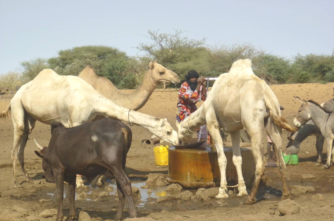
Farming and livestock keeping continue to be the most important socio-economic activities. The agricultural crops produced include millet, sorghum, maize, cowpea, rice and groundnut. In 2009, a total area of 345.5 ha was sown for these crops. The Sahel region in Burkina Faso has excellent conditions for livestock keeping. The animal species found in the region are mainly cattle, sheep, goats, pigs, camels, donkeys and horses and poultry. Several facilities and installations for water supply to pastoral areas are available in the region, as well as storage facilities for agricultural and agro-industrial by-products (SPAI) and infrastructure for trade and animal health care. The municipality of Déou disposes of one reservoir, five artificial ponds, 43 firm wells, ten vaccination centers, one store for agricultural and agro-industrial by-products (SPAI), one animal shelter, a facility for slaughtering and a livestock market.
The well called 'Forage Christine' was constructed in 1971 by a French engineer, which named it after his wife, and opened it for the first time in 1972. Due to conflicts between Burkina and Mali it was ruined in 1976, and then again in 1985. In 1996 the National Office for Wells and Boreholes (ONFP), a government agency, rehabilitated the well and made two supplementary boreholes. The complex consists of a main well with an operating flow rate of 120 m3/h, having a submersible pump of brand KSB, type OPA 150s-65/8, and a pump capacity of 60 m3/h. Next to the main well there is a secondary well, which is equipped with a hand-operated pump with a capacity of 18 m3/h.
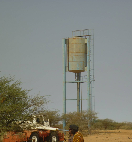
The energy for pumping water from the wells is provided by a generator with an engine of brand DEUTZ (type: F3 - 6L 912) and a switch of brand LEROY SOMER – Type LSA 42.1 L8L C1/4, a voltage of 400 V and continuous power of 50 kW. The generator has a switch and a battery. A diesel tank with a volume of approximately 9 m3 was installed for the power supply to the generator. The pumped water is stored in an elevated water tank, which is located at a distance of about 200 m from the well, and has a volume of 50 m3. The water from the elevated water tank is distributed to four artificial ponds with a dimension of 50 m x 50 m x 1.5 m at equal distances on all sides of the central reservoir. The water is conducted to the artificial ponds through PVC piping, which is buried underground over a distance of 8 km, or 2 km for each pond. The water flow is controlled by nine valves of type Nr. 4000, Reg. Nr. W 1.129, installed on the pipes. The hydraulic complex was installed in 1996 by the National Agency for Water and Sanitation (ONEA). The complex is managed by the livestock keepers through the User Association of 'Forage Christine' (AUFC). The statutes of this organisation were adopted on 2 May 2014. The well is managed according to a set of requirements which specify the terms for access to water: date of opening and closure of the well, the amount to be paid per animal and the management of the cash money provided.
2.3 Fotografías de la Tecnología
Galería de medios
Comentarios generales sobre las fotos:
The dates of the picture and the photographer are unknown.
2.4 Videos de la Tecnología
Comentarios, descripción breve:
No video
2.5 País/ región/ lugares donde la Tecnología fue aplicada y que se hallan comprendidos por esta evaluación
País:
Burkina Faso
Región/ Estado/ Provincia:
Sahel/Oudalan
Especifique más el lugar :
Déou
Comentarios:
The infrastructure was created in 1971, but the facilities for use were installed in 1996.
Map
×2.6 Fecha de la implementación
Indique año de implementación:
1971
2.7 Introducción de la Tecnología
Especifique cómo se introdujo la Tecnología:
- mediante proyectos/ intervenciones externas
Comentarios (tipo de proyecto, etc.):
A French aid worker introduced the technology with support from the government of Burkina Faso, through the National Agency for Water and Sanitation (ONEA).
3. Clasificación de la Tecnología MST
3.1 Propósito(s) principal(es) de la Tecnología MST
- adaptarse al cambio climático/ extremos climáticos y sus impactos
- crear impacto económico benéfico
- crear impacto social benéfico
3.2 Tipo(s) actuales de uso de la tierra donde se aplica la Tecnología

Tierras cultivadas

Tierra de pastoreo
Tierras de pastoreo extensivo:
- Semi-nomadismo/ pastoralismo
Especies y productos animales principales:
Animal species: cattle, sheep, camels, donkeys and goats.
Comentarios:
In addition to livestock keeping, subsistence farming is practiced. The main crops are sorghum, millet, groundnut and cowpea. The size of the fields varies between 0.5 and 3 ha. The farm type is family-based.
Si el uso de la tierra ha cambiado debido a la implementación de la Tecnología, indique el uso de la tierra antes de la implementación de la Tecnología.
No change in land use due to the implementation of the technology.
3.3 Información adicional sobre el uso de tierras
Provisión de agua para la tierra donde se aplica la Tecnología:
- de secano
Número de temporadas de cultivo por año:
- 1
Especifique:
Mid-June to September
3.4 Grupo MST al que pertenece la Tecnología
- pastoralismo y manejo de tierras de pastoreo
- manejo de agua subterránea
3.5 Difusión de la Tecnología
Especifique la difusión de la Tecnología:
- aplicada en puntos específicos/ concentrada en un área pequeña
Comentarios:
The well is located in the municipality of Déou, but is used for livestock from the entire Sahel region in Burkina Faso, Mali and Niger.
3.6 Medidas MST que componen la Tecnología

medidas estructurales
- S7: Equipo para cosechar agua / provisión de agua/ irrigación
3.7 Principales tipos de degradación del suelo encarados con la Tecnología

degradación del agua
- Ha: aridificación
- Hs: cambio en la cantidad de aguas superficiales
- Hg: cambio en nivel de aguas subterráneas/ nivel de acuífero
- Hq: reducción de la calidad de subterráneas

otros
Comentarios:
The technology aims to remediate water scarcity for livestock during the dry season.
3.8 Prevención, reducción o restauración de la degradación del suelo
Especifique la meta de la Tecnología con relación a la degradación de la tierra:
- reducir la degradación del suelo
4. Especificaciones técnicas, actividades de implementación, insumos y costos
4.1 Dibujo técnico de la Tecnología
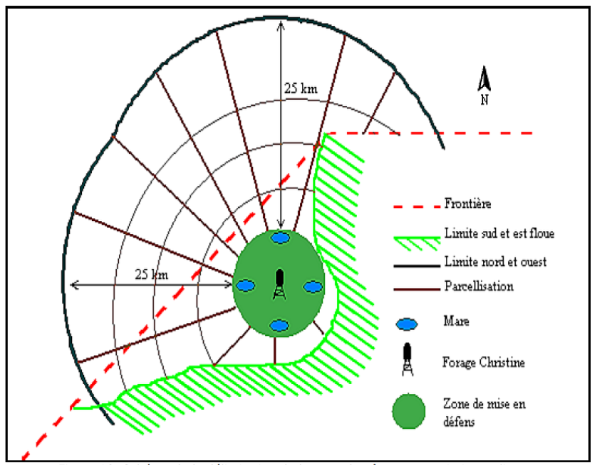
Autor:
SNV
4.2 Especificaciones técnicas/ explicaciones del dibujo técnico
1. Main well, flow rate 120 m3/h.
2. Secondary well, flow rate 18 m3/h.
3. Submersible pump, brand KSB, type OPA 150s-65/8, flow rate 60m3/h, year of constrcuction1996
4. Elevated water storage tank, volume 50 m3.
5. Four ponds of 50 m x 50 m x 1.5 m.
4.3 Información general sobre el cálculo de insumos y costos
Especifique cómo se calcularon los costos e insumos:
- por unidad de Tecnología
otra / moneda nacional (especifique):
FCFA
Indique la tasa de cambio de USD a la moneda local (si fuese relevante): 1 USD =:
550,0
Indique el costo promedio del salario de trabajo contratado por día:
35 000 per month
4.4 Actividades de establecimiento
| Actividad | Tipo de medida | Momento | |
|---|---|---|---|
| 1. | Main well | Estructurales | |
| 2. | Elevated water storage tank | Estructurales | |
| 3. | Artificial ponds | Estructurales |
Comentarios:
Not evaluated.
4.5 Costos e insumos necesarios para el establecimiento
Comentarios:
Not applicable.
4.6 Actividades de establecimiento/ recurrentes
| Actividad | Tipo de medida | Momento/ frequencia | |
|---|---|---|---|
| 1. | Use of diesel | Manejo | year |
| 2. | Use of oil and filters | Manejo | year |
| 3. | Periodic maintenance of the generator | Manejo | year |
| 4. | Fuel delivery | Manejo | year |
| 5. | Transport costs of the maintenance operator | Manejo | year |
| 6. | Wage of the guard | Manejo | year |
| 7. | Compensation of the manager of the generator | Manejo | year |
| 8. | Charges for accounting | Manejo | year |
4.7 Costos e insumos necesarios para actividades de mantenimiento/ recurrentes (por año)
| Especifique insumo | Unidad | Cantidad | Costos por unidad | Costos totales por insumo | % de los costos cubiertos por los usuarios de las tierras | |
|---|---|---|---|---|---|---|
| Mano de obra | Periodic maintenance of the generator | season | 1,0 | 150000,0 | 150000,0 | |
| Mano de obra | Compensation of the GE manager | person-month | 12,0 | 37500,0 | 450000,0 | |
| Mano de obra | Charges for accounting | person-month | 12,0 | 175,0 | 2100,0 | |
| Mano de obra | Wage of the guard | person-month | 12,0 | 50000,0 | 600000,0 | |
| Otros | Use of diesel | season | 1,0 | 2921000,0 | 2921000,0 | |
| Otros | Use of oil, filters | season | 1,0 | 68000,0 | 68000,0 | |
| Otros | Reparations to the hydraulic complex | season | ||||
| Otros | Fuel delivery | season | 1,0 | 125000,0 | 125000,0 | |
| Otros | Transport costs of maintenance operator | season | 1,0 | 60000,0 | 60000,0 | |
| Indique los costos totales para mantenecer la Tecnología | 4376100,0 | |||||
Si el usuario de la tierra no cubrió el 100% de los costos, indique quién financió el resto del costo:
The municipality, the management committee and the NGOs operating in the area (SNV).
4.8 Factores más determinantes que afectan los costos:
Describa los factores más determinantes que afectan los costos:
1. Availability of fuel for the generator.
2. Failures in the functioning of the generator to fill the storage tanks.
5. Entorno natural y humano
5.1 Clima
Lluvia anual
- < 250 mm
- 251-500 mm
- 501-750 mm
- 751-1,000 mm
- 1,001-1,500 mm
- 1,501-2,000 mm
- 2,001-3,000 mm
- 3,001-4,000 mm
- > 4,000 mm
Especifique el promedio anual de lluvia (si lo conoce), en mm:
500,00
Especificaciones/ comentarios sobre la cantidad de lluvia:
Mean annual rainfall is around 500 mm, with approximately 30 rainy days and characterized by a strong variation between years. The water system has many streams, of which only one is permanent (the Béli river). To this river, ponds and many depressions are connected, which disappear after the month of January.
Indique el nombre de la estación metereológica de referencia considerada:
Station of Gorom-Gorom
Zona agroclimática
- semi-árida
The climate is of Sahelian type, and has a rainy season of 3 to 4 months (from June-July to September), which is subject to strong temporal and spatial variations in precipitation, and a dry season of 8 to 9 months. The climatic conditions are characterized by highly irregular winds, precipitation, evapotranspiration and moisture due to fluctuations in atmospheric circulation patterns.
5.2 Topografía
Pendientes en promedio:
- plana (0-2 %)
- ligera (3-5%)
- moderada (6-10%)
- ondulada (11-15%)
- accidentada (16-30%)
- empinada (31-60%)
- muy empinada (>60%)
Formaciones telúricas:
- meseta/ planicies
- cordilleras
- laderas montañosas
- laderas de cerro
- pies de monte
- fondo del valle
Zona altitudinal:
- 0-100 m s.n.m.
- 101-500 m s.n.m.
- 501-1,000 m s.n.m
- 1,001-1,500 m s.n.m
- 1,501-2,000 m s.n.m
- 2,001-2,500 m s.n.m
- 2,501-3,000 m s.n.m
- 3,001-4,000 m s.n.m
- > 4,000 m s.n.m
5.3 Suelos
Profundidad promedio del suelo:
- muy superficial (0-20 cm)
- superficial (21-50 cm)
- moderadamente profunda (51-80 cm)
- profunda (81-120 cm)
- muy profunda (>120 cm)
Textura del suelo (capa arable):
- áspera/ ligera (arenosa)
Textura del suelo (> 20 cm debajo de la superficie):
- áspera/ ligera (arenosa)
Materia orgánica de capa arable:
- baja (<1%)
Si se halla disponible, adjunte una descripción completa de los suelos o especifique la información disponible, por ej., tipo de suelo, pH/ acidez de suelo, capacidad de intercambio catiónico, nitrógeno, salinidad, etc. :
The soils are very diverse in general, and mostly of sandy texture. They do not provide a good medium for plant growth due to the low permeability, which reduces water infiltration.
5.4 Disponibilidad y calidad de agua
Agua subterránea:
en superficie
Disponibilidad de aguas superficiales:
pobre/ ninguna
Calidad de agua (sin tratar):
agua potable de mala calidad (requiere tratamiento)
¿La salinidad del agua es un problema?
No
¿Se está llevando a cabo la inundación del área? :
No
Comentarios y especificaciones adicionales sobre calidad y cantidad de agua:
Limited water availability appears to be one of the major limitations for rainfed agriculture, in addition to the low retention and availability of nutrients.
5.5 Biodiversidad
Diversidad de especies:
- mediana
Diversidad de hábitats:
- baja
Comentarios y especificaciones adicionales sobre biodiversidad:
The area around the 'Forage Christine' is characterized by a variety of typical Saharan and Sahelian vegetation units which mainly occur in shrub and woody steppes (48.85%) and grassy steppes (24.37%), and which form the larger part of the rangelands.
5.6 Las características de los usuarios de la tierra que aplican la Tecnología
Sedentario o nómada:
- Sedentario
- Semi-nómada
Orientación del mercado del sistema de producción:
- subsistencia (autoprovisionamiento)
Ingresos no agrarios:
- menos del 10% de todos los ingresos
Nivel relativo de riqueza:
- muy pobre
- pobre
Individuos o grupos:
- individual/ doméstico
- grupos/ comunal
Nivel de mecanización:
- trabajo manual
- tracción animal
Género:
- mujeres
- hombres
Edad de los usuarios de la tierra:
- jóvenes
- personas de mediana edad
Indique otras características relevantes de los usuarios de las tierras:
Several socio-economic groups are guiding the activities of land users. These include 60 farmer groups, 53 groups of livestock keepers, six of which for female livestock keepers, and three organisations for environmental protection.
5.7 Área promedio de la tierra que pertenece a o es arrendada por usuarios de tierra que aplican la Tecnología
- < 0.5 ha
- 0.5-1 ha
- 1-2 ha
- 2-5 ha
- 5-15 ha
- 15-50 ha
- 50-100 ha
- 100-500 ha
- 500-1,000 ha
- 1,000-10,000 ha
- > 10,000 ha
¿Esto se considera de pequeña, mediana o gran escala (refiriéndose al contexto local)?
- pequeña escala
- escala mediana
Comentarios:
Most of the agro pastoralist are smallholder farmers, livestock keeping is their main livelihood activity.
5.8 Tenencia de tierra, uso de tierra y derechos de uso de agua
Tenencia de tierra:
- estado
- comunitaria/ aldea
Derechos de uso de tierra:
- acceso abierto (no organizado)
- comunitarios (organizado)
Derechos de uso de agua:
- acceso abierto (no organizado)
- comunitarios (organizado)
5.9 Acceso a servicios e infraestructura
salud:
- pobre
- moderado
- bueno
educación:
- pobre
- moderado
- bueno
asistencia técnica:
- pobre
- moderado
- bueno
empleo (ej. fuera de la granja):
- pobre
- moderado
- bueno
mercados:
- pobre
- moderado
- bueno
energía:
- pobre
- moderado
- bueno
caminos y transporte:
- pobre
- moderado
- bueno
agua potable y saneamiento:
- pobre
- moderado
- bueno
servicios financieros:
- pobre
- moderado
- bueno
6. Impactos y comentarios para concluir
6.1 Impactos in situ demostrados por la Tecnología
Impactos socioeconómicos
Producción
producción animal
Disponibilidad y calidad de agua
disponibilidad de agua para ganado
calidad de agua para ganado
Impactos socioculturales
derechos de uso de la tierra/ agua
Impactos ecológicos
Reducción de riesgos de desastres y riesgos climáticos
impactos de sequías
6.2 Impactos fuera del sitio demostrados por la Tecnología
disponibilidad de agua
corriente confiable y estable fluye en estación seca
6.3 Exposición y sensibilidad de la Tecnología al cambio climático gradual y a extremos relacionados al clima/ desastres (desde la percepción de los usuarios de tierras)
Extremos (desastres) relacionados al clima
Desastres climatológicos
| ¿Cómo es que la tecnología soporta esto? | |
|---|---|
| sequía | muy bien |
6.4 Análisis costo-beneficio
¿Cómo se comparan los beneficios con los costos de establecimiento (desde la perspectiva de los usuarios de tierra)?
Ingresos a corto plazo:
muy positivo
Ingresos a largo plazo:
muy positivo
¿Cómo se comparan los beneficios con los costos de mantenimiento/ recurrentes (desde la perspectiva de los usuarios de tierra)?
Ingresos a corto plazo:
muy positivo
Ingresos a largo plazo:
muy positivo
6.5 Adopción de la Tecnología
- más de 50%
Comentarios:
Not applicable
6.6 Adaptación
¿La tecnología fue modificada recientemente para adaptarse a las condiciones cambiantes?
No
6.7 Fuerzas/ ventajas/ oportunidades de la Tecnología
| Fuerzas/ ventajas/ oportunidades desde la perspectiva del usuario de la tierra |
|---|
| Existence of a temporary coordinating committee on the site of the well, acting as an interface between the authorities and the livestock keepers using the well. |
| The arrangement of the use of the artificial ponds according to the terms set by the authorities and the technical services. |
| Monitoring of animal health and informing the livestock keeping service in case of suspected infectious diseases. |
| Fuerzas/ ventajas/ oportunidades desde la perspectiva del compilador o de otra persona de referencia clave |
|---|
| Water availability and access to water for users when the well is operational; potential users are willing to contribute to the operation of the well. |
| Water availability for livestock. |
| Strong involvement of the authorities and the technical services in issues relating to 'Forage Christine'. |
| Implementation of several methods to solve management problems. |
| Good organisation of the management of the water source. |
6.8 Debilidades/ desventajas/ riesgos de la Tecnología y formas de sobreponerse a ellos
| Debilidades/ desventajas/ riesgos desde la perspectiva del usuario de la tierra | ¿Cómo sobreponerse a ellas? |
|---|---|
| Lack of transparency in the use and management of contributions intended to cover the functioning and the maintenance of the generator and the wage of the guard, who also operates the generator and supervises the related installations. | Good functioning of the management committee and committee meetings will enable to overcome this disadvantage. |
| A low level of representation of the different population groups in the management committee (only the Djelgobé of Gandéfabou are members; these people settled in the area in Boula and claim to be the indigenous people in the area). | Involving all groups using the well more closely in order to have an appropriate representative in the management committee. |
| Lack of consultation between the management committee and the livestock keepers having their residence in the area. | Stimulating the management committee to communicate more closely with the neighboring livestock keepers through a framework for consultation on the way in which they manage the infrastructure of the 'Forage Christine'. |
| Insufficient awareness of the roles and responsibilities of the management committee by the livestock keepers (only the role of the guard is known to the livestock keepers). | |
| The undemocratic establishment of the management committee (self-appointed members), which explains why livestock keepers consider the committee as an imposed structure. |
| Debilidades/ desventajas/ riesgos desde la perspectiva del compilador o de otra persona de referencia clave | ¿Cómo sobreponerse a ellas? |
|---|---|
| The non-involvement of livestock keepers (potential users) in the management of the well in some management methods (concession to RMC); their weak involvement in the management of the well, and their continued low representation in the committees (2 to 3 persons). | Involving livestock keepers more closely in the management committees and in the decision-making bodies related to 'Forage Christine'. Increasing the number of representatives of livestock keepers in the management bodies of the well. |
| The failure to address the concerns of livestock keepers in the implementation of the management methods. | Ensuring that the livestock keepers are considered by the management committee, and that they can effectively participate in the committee. |
| The inappropriate use of contributions from users of the well for operating the facilities of the well in a sustainable way. | Ensuring that the funds generated by the well are managed properly by the management committee. |
| Competition for water between humans and animals. | Providing wells or pumps for human consumption of water. |
| Huge inflow of animals which overgraze the area, thereby threatening the environment. | Raising awareness among livestock keepers and herders on the need to manage the natural resources properly in the area influenced by 'Forage Christine', with the aim to mitigate the environmental degradation that could result from overgrazing. |
7. Referencias y vínculos
7.1 Métodos/ fuentes de información
- visitas de campo, encuestas de campo
03
- compilación de informes y otra documentación existente
03
7.2 Vínculos a las publicaciones disponibles
Título, autor, año, ISBN:
Boundaoné et al., 2015. Textes fondamentaux et outils de gestion du forage Christine, PGP-FC/GRP, SVN, 60 p.
Título, autor, año, ISBN:
SNV, 2011. Etude pour la sécurisation des ressources foncières pastorales autour du Forage Christine dans la province de l’Oudalan. Final report, 142 p.
7.3 Vínculos a la información relevante disponible en línea
Título/ descripción:
News paper article: Elevage dans le Sahel : "Christine" ou le symbole de l’hydraulique pastorale.
URL:
http://lefaso.net/spip.php?article31821
Vínculos y módulos
Expandir todo Colapsar todosVínculos
No hay vínculos
Módulos
No se hallaron módulos