Permeable rock dikes [Burkina Faso]
- Creación:
- Actualización:
- Compilador: Dieter Nill
- Editor: –
- Revisores: Deborah Niggli, Alexandra Gavilano
Diguettes filtrantes (French)
technologies_1619 - Burkina Faso
Visualizar secciones
Expandir todo Colapsar todos1. Información general
1.2 Detalles de contacto de las personas de referencia e instituciones involucradas en la evaluación y la documentación de la Tecnología
Especialista MST:
Sani Mamadou Abdou
Programme d’Appui à l’agriculture Productive (PROMAP), Niamey, Niger
Níger
Nombre del proyecto que financió la documentación/ evaluación de la Tecnología (si fuera relevante)
Good Practices in Soil and Water Conservation - A contribution to adaptation and farmers ́ resilience towards climate change in the Sahel (GIZ)Nombre de la(s) institución(es) que facilitaron la documentación/ evaluación de la Tecnología (si fuera relevante)
Deutsche Gesellschaft für Internationale Zusammenarbeit (GIZ) - Alemania1.3 Condiciones referidas al uso de datos documentados mediante WOCAT
El compilador y la/s persona(s) de referencia claves aceptan las condiciones acerca del uso de los datos documentados mediante WOCAT:
Sí
1.4 Declaración de la sostenibilidad de la Tecnología descrita
¿La Tecnología aquí descrita resulta problemática en relación a la degradación de la tierra, de tal forma que no puede considerársela una tecnología sostenible para el manejo de la tierra?
No
2. Descripción de la Tecnología MST
2.1 Breve descripción de la Tecnología
Definición de la Tecnología:
Permeable rock dikes are erosion control structures to slow down runoff
2.2 Descripción detallada de la Tecnología
Descripción:
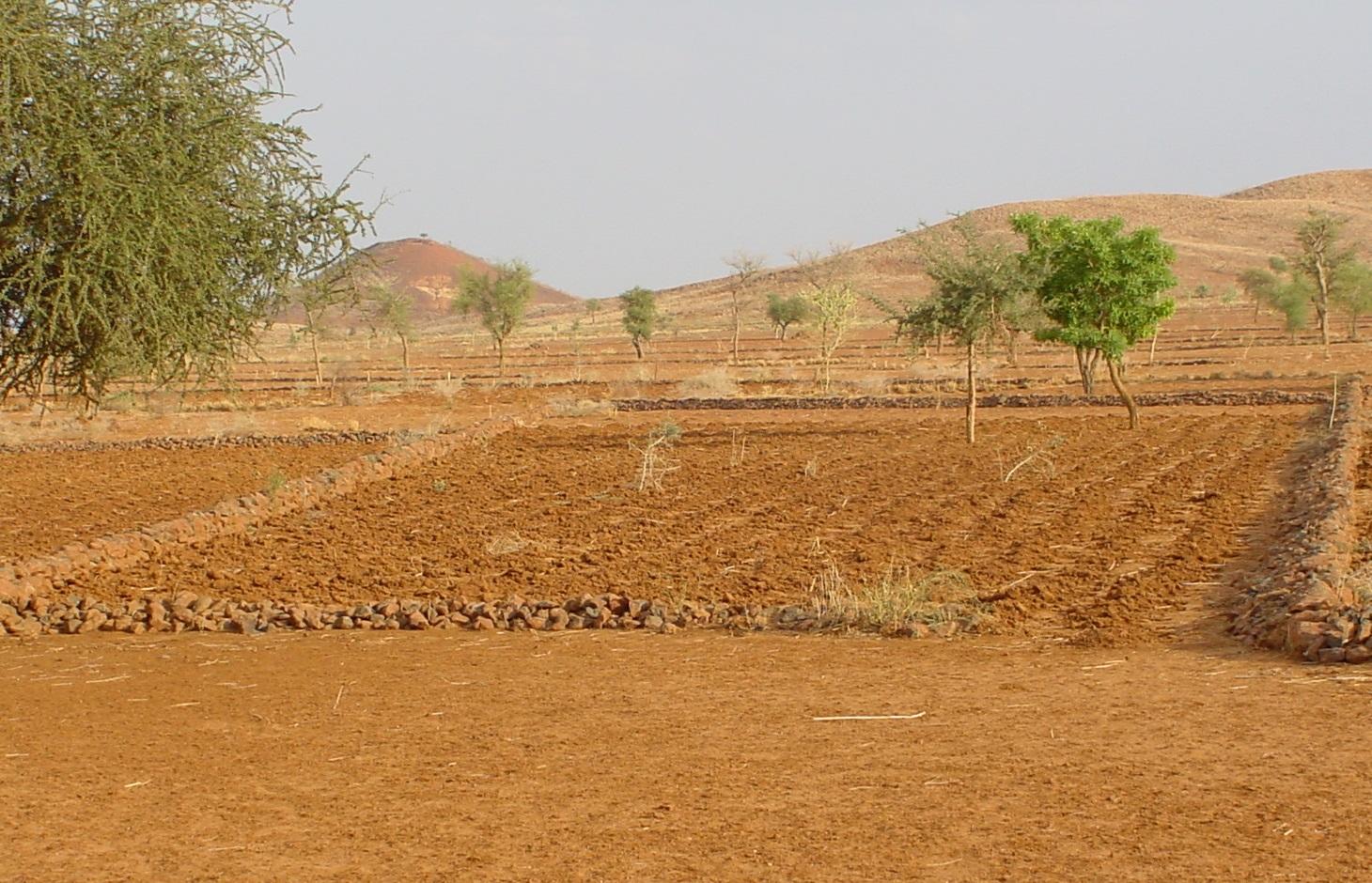
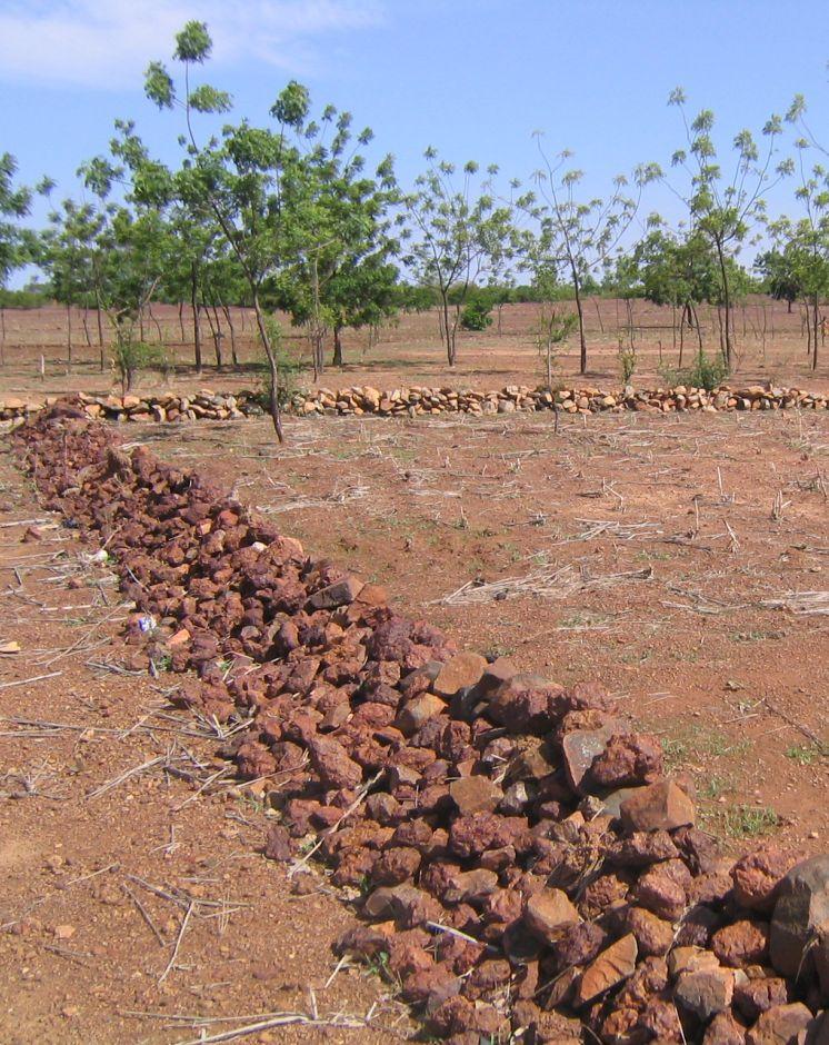
Permeable rock dikes are erosion control structures built along the natural contour of the land and designed to slow down runoff. They are built between 30 and 50 cm high and twice or three times as wide as they are high. They are made with different-sized stones and rocks, and the crest of the dike is horizontal. There are two main types of permeable rock dike: those without a filter layer, which are suitable for flat land with no gully erosion and those with a filter layer suited to land with heavy runoff.
Because of the way it is constructed, it dissipates the erosive force of the water. Sediment builds up behind it, resulting in the formation of terraces. It also increases the infiltration of surface water into the soil. The retention of water and fertile sediment by the dikes facilitates the development of natural vegetation along the structure. Grass and bush seeds are trapped by the dikes, favouring the spontaneous growth of natural vegetation, which contributes to restoring biodiversity and provides a habitat for wildlife. Good tree and grass cover developed along the dikes contributes to lowering soil temperature and reducing wind erosion along the entire length of the structure.
The reduction in runoff downstream of the dikes contributes to reducing alluvial deposits in the valleys further downstream. Watershed development with permeable rock dikes reduces siltation and gully erosion.
Permeable rock dikes are designed for use on cropland, but can also be used on forest/rangeland. They are recommended for ecological units with gravely and sandy-clayey soils and pediments. They can also be used to fill in small rills.
Studies conducted in the PATECORE area show that plots with permeable rock dikes averaged sorghum yields of 795 kg compared with 576 kg on control plots, which means that yields were 38% higher on improved plots. The production of straw for livestock increases in the same proportion as grain output.
With some upkeep, permeable rock dikes last at least 20 years. Before the rainy season starts, any stones dislodged by animals must be replaced. During the rainy season, the water can wear gaps in the dikes, which must be repaired immediately. The stability of the dikes can be reinforced by active revegetation (by sowing grass or planting trees). Without direct sowing, natural vegetation develops along the dikes after several years.
From the point of view of climate change adaptation, permeable rock dikes mitigate the effects of variations in rainfall. They are appropriate in wet period with heavy rain and violent downpours: permeable rock dikes constructed on the upper edge of the plot as a protective measure and a means of improving infiltration, protect land at risk from erosion. They are also appropriate during dry periods as they stop or slow down the flow of water. Permeable rock dikes improve infiltration and therefore increase and prolong the availability of water for crops. The permeable rock dike differs from the contour stone bund in that it is bigger in size, is constructed with various layers of stones and is designed to control stronger water flow. For this reason, such dikes are often constructed up-stream of stone bunds to dissipate the force of the water flowing from the plateaux and slopes.
2.3 Fotografías de la Tecnología
Galería de medios
2.5 País/ región/ lugares donde la Tecnología fue aplicada y que se hallan comprendidos por esta evaluación
País:
Burkina Faso
Región/ Estado/ Provincia:
Burkina Faso, Chad
2.6 Fecha de la implementación
Si no se conoce el año preciso, indique la fecha aproximada:
- 10-50 años atrás
2.7 Introducción de la Tecnología
Especifique cómo se introdujo la Tecnología:
- mediante proyectos/ intervenciones externas
Comentarios (tipo de proyecto, etc.):
developed, implemented and disseminated as part of projects and programmes undertaken from the 1980s onwards to combat desertification and improve natural resource management. Implemented by GIZ (German Federal Enterprise for International Cooperation), and PATECORE (project for land development and resource conservation in Plateau Central)
3. Clasificación de la Tecnología MST
3.1 Propósito(s) principal(es) de la Tecnología MST
- reducir, prevenir, restaurar la degradación del suelo
3.2 Tipo(s) actuales de uso de la tierra donde se aplica la Tecnología

Tierras cultivadas
- Cosecha anual
Número de temporadas de cultivo por año:
- 1
Especifique:
Longest growing period in days: 120, Longest growing period from month to month: August to October

Tierra de pastoreo
Pastoreo extenso:
- Pastoralismo semi-nómada
Comentarios:
Major land use problems (compiler’s opinion): surface runoff, soil erosion by water and wind, fertility decline
Constraints of common grazing land
Constraints of forested government-owned land or commons
3.5 Grupo MST al que pertenece la Tecnología
- medida de pendiente transversal
3.6 Medidas MST que componen la Tecnología

medidas estructurales
- S2: Taludes, bancos
3.7 Principales tipos de degradación del suelo encarados con la Tecnología

erosión de suelos por agua
- Wt: pérdida de capa arable/ erosión de la superficie
- Wg: erosión en cárcavas
- Wo: efectos de degradación fuera del sitio

erosión de suelos por viento
- Et: pérdida de capa arable

deterioro químico del suelo
- Cn: reducción de la fertilidad y contenido reducido de la materia orgánica del suelo (no ocasionados por la erosión)

degradación biológica
- Bc: reducción de la cobertura vegetal del suelo

degradación del agua
- Ha: aridificación
Comentarios:
Main causes of degradation: crop management (annual, perennial, tree/shrub) (Unadapted landuse methods, reduced or abandoned fallow periods), floods, droughts, population pressure (rapidly growing population increasing pressure on land), land tenure (insecure access to land)
3.8 Prevención, reducción o restauración de la degradación del suelo
Especifique la meta de la Tecnología con relación a la degradación de la tierra:
- reducir la degradación del suelo
- restaurar/ rehabilitar tierra severamente degradada
4. Especificaciones técnicas, actividades de implementación, insumos y costos
4.1 Dibujo técnico de la Tecnología
Especificaciones técnicas (relacionadas al dibujo técnico):
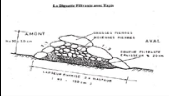
Permeable rock dikes are built between 30 and 50 cm high and twice or three times as wide as they are high. They are made with different-sized stones and rocks, and the crest of the dike is horizontal. There are two main types of permeable rock dike: those without a filter layer, which are suitable for flat land with no gully erosion and those with a filter layer suited to land with heavy runoff.
Technical knowledge required for field staff / advisors: moderate
Technical knowledge required for land users: low
Main technical functions: control of dispersed runoff: retain / trap, control of dispersed runoff: impede / retard, control of concentrated runoff: retain / trap, control of concentrated runoff: impede / retard, control of concentrated runoff: drain / divert, reduction of slope angle, improvement of ground cover, increase in nutrient availability (supply, recycling,…), increase of infiltration, increase / maintain water stored in soil, water harvesting / increase water supply, sediment retention / trapping, sediment harvesting
Secondary technical functions: stabilisation of soil (eg by tree roots against land slides), increase in organic matter, increase of groundwater level / recharge of groundwater, reduction in wind speed, promotion of vegetation species and varieties (quality, eg palatable fodder)
Bund/ bank: graded
Height of bunds/banks/others (m): 0.3-0.5
Width of bunds/banks/others (m): 1.5
Autor:
PATECORE, GIZ
4.3 Actividades de establecimiento
| Actividad | Momento (estación) | |
|---|---|---|
| 1. | levelling and marking out the contour line | |
| 2. | collecting stones and loading them onto carts | |
| 3. | transporting the stones by cart | |
| 4. | building the dikes | |
| 5. | applying manure |
4.5 Actividades de establecimiento/ recurrentes
| Actividad | Momento/ frequencia | |
|---|---|---|
| 1. | Before the rainy season starts, any stones dislodged by animals must be replaced. | |
| 2. | During the rainy season, the water can wear gaps in the dikes, which must be repaired immediately. |
4.6 Costos e insumos necesarios para actividades de mantenimiento/ recurrentes (por año)
Comentarios:
Machinery/ tools: pickaxes, shovels, wheelbarrows, water-tube level, etc.
4.7 Factores más determinantes que afectan los costos:
Describa los factores más determinantes que afectan los costos:
The exact cost of constructing permeable rock dikes per hectare depends on the distance of the site from the quarry, the inclination of the terrain, which determines the spacing between the dikes, and the actual amount of stones transported in each lorryload or cartload. Supply of quarry rock/stones: 48 m3 for 200 m of dike.
Labour: 60 man-days per ha
• levelling and marking out the contour line: 1 man-day
• collecting stones and loading them onto carts:
20 man-days
• transporting the stones by cart: 20 man-days
• building the dikes: 19 man-days
• applying manure.
Transportation by cart:
• 20 cartloads of stones
• 20 cartloads of manure (if used).
Transportation by lorry:
• 11 lorryloads (skip loader – 4.5 m3 per load).
Other costs:
• equipment (pickaxes, shovels, wheelbarrows, water-tube level, etc.).
5. Entorno natural y humano
5.1 Clima
Lluvia anual
- < 250 mm
- 251-500 mm
- 501-750 mm
- 751-1,000 mm
- 1,001-1,500 mm
- 1,501-2,000 mm
- 2,001-3,000 mm
- 3,001-4,000 mm
- > 4,000 mm
Zona agroclimática
- semi-árida
Thermal climate class: subtropics
5.2 Topografía
Pendientes en promedio:
- plana (0-2 %)
- ligera (3-5%)
- moderada (6-10%)
- ondulada (11-15%)
- accidentada (16-30%)
- empinada (31-60%)
- muy empinada (>60%)
Formaciones telúricas:
- meseta/ planicies
- cordilleras
- laderas montañosas
- laderas de cerro
- pies de monte
- fondo del valle
Zona altitudinal:
- 0-100 m s.n.m.
- 101-500 m s.n.m.
- 501-1,000 m s.n.m
- 1,001-1,500 m s.n.m
- 1,501-2,000 m s.n.m
- 2,001-2,500 m s.n.m
- 2,501-3,000 m s.n.m
- 3,001-4,000 m s.n.m
- > 4,000 m s.n.m
5.3 Suelos
Profundidad promedio del suelo:
- muy superficial (0-20 cm)
- superficial (21-50 cm)
- moderadamente profunda (51-80 cm)
- profunda (81-120 cm)
- muy profunda (>120 cm)
Textura del suelo (capa arable):
- mediana (limosa)
- fina/ pesada (arcilla)
Textura del suelo (> 20 cm debajo de la superficie):
- mediana (limosa)
- fina/ pesada (arcilla)
5.4 Disponibilidad y calidad de agua
Agua subterránea:
5-50 m
Disponibilidad de aguas superficiales:
mediana
5.5 Biodiversidad
Diversidad de especies:
- baja
5.6 Las características de los usuarios de la tierra que aplican la Tecnología
Nivel relativo de riqueza:
- muy pobre
- pobre
Género:
- hombres
Indique otras características relevantes de los usuarios de las tierras:
Population density: 10-50 persons/km2
Annual population growth: 3% - 4% (mostly poor households below poverty line).
Off-farm income specification: men migrate temporarily or permanently to cities for off-farm income
5.7 Área promedio de la tierra usada por usuarios de tierra que aplican la Tecnología
- < 0.5 ha
- 0.5-1 ha
- 1-2 ha
- 2-5 ha
- 5-15 ha
- 15-50 ha
- 50-100 ha
- 100-500 ha
- 500-1,000 ha
- 1,000-10,000 ha
- > 10,000 ha
¿Esto se considera de pequeña, mediana o gran escala (refiriéndose al contexto local)?
- pequeña escala
5.8 Tenencia de tierra, uso de tierra y derechos de uso de agua
Tenencia de tierra:
- estado
Derechos de uso de tierra:
- comunitarios (organizado)
Derechos de uso de agua:
- comunitarios (organizado)
Comentarios:
traditional land use rights on fields, communal land on pasture and forest land
5.9 Acceso a servicios e infraestructura
salud:
- pobre
- moderado
- bueno
educación:
- pobre
- moderado
- bueno
asistencia técnica:
- pobre
- moderado
- bueno
empleo (ej. fuera de la granja):
- pobre
- moderado
- bueno
mercados:
- pobre
- moderado
- bueno
energía:
- pobre
- moderado
- bueno
caminos y transporte:
- pobre
- moderado
- bueno
agua potable y saneamiento:
- pobre
- moderado
- bueno
servicios financieros:
- pobre
- moderado
- bueno
6. Impactos y comentarios para concluir
6.1 Impactos in situ demostrados por la Tecnología
Impactos socioeconómicos
Producción
producción de cultivo
producción de forraje
riesgo de fracaso de producción
Ingreso y costos
ingreso agrario
Impactos socioculturales
seguridad alimentaria/ autosuficiencia
mitigación de conflicto
contribution to human well-being
Comentarios/ especifique:
Studies conducted in the PATECORE area show that plots with permeable rock dikes averaged sorghum yields of 795 kg compared with 576 kg on control plots, which means that yields were 38% higher on improved plots. The production of straw for livestock increases in the same proportion as grain output.
Impactos ecológicos
Ciclo de agua/ escurrimiento de sedimento
cosecha/ recolección de agua
escurrimiento superficial
nivel freático/ acuífero
Suelo
humedad del suelo
cubierta del suelo
pérdida de suelo
ciclo/ recarga de nutrientes
Biodiversidad: vegetación, animales
diversidad vegetal
Reducción de riesgos de desastres y riesgos climáticos
velocidad de viento
6.2 Impactos fuera del sitio demostrados por la Tecnología
inundaciones río abajo
colmatación río abajo
sedimentos transportados por el viento
daño a campos de vecinos
6.3 Exposición y sensibilidad de la Tecnología al cambio climático gradual y a extremos relacionados al clima/ desastres (desde la percepción de los usuarios de tierras)
Cambio climático gradual
Cambio climático gradual
| Estación | Incremento o reducción | ¿Cómo es que la tecnología soporta esto? | |
|---|---|---|---|
| temperatura anual | incrementó | bien |
Extremos (desastres) relacionados al clima
Desastres climatológicos:
| ¿Cómo es que la tecnología soporta esto? | |
|---|---|
| tormenta de lluvia local | bien |
| tormenta de viento | bien |
Desastres climatológicos
| ¿Cómo es que la tecnología soporta esto? | |
|---|---|
| sequía | bien |
Desastres hidrológicos
| ¿Cómo es que la tecnología soporta esto? | |
|---|---|
| inundación general (río) | no muy bien |
Otras consecuencias relacionadas al clima
Otras consecuencias relacionadas al clima
| ¿Cómo es que la tecnología soporta esto? | |
|---|---|
| periodo reducido de crecimiento | bien |
6.4 Análisis costo-beneficio
¿Cómo se comparan los beneficios con los costos de establecimiento (desde la perspectiva de los usuarios de tierra)?
Ingresos a corto plazo:
positivo
Ingresos a largo plazo:
muy positivo
¿Cómo se comparan los beneficios con los costos de mantenimiento/ recurrentes (desde la perspectiva de los usuarios de tierra)?
Ingresos a corto plazo:
muy positivo
Ingresos a largo plazo:
muy positivo
6.5 Adopción de la Tecnología
Comentarios:
There is a little trend towards spontaneous adoption of the Technology
The technique’s potential for replication depends on the type of terrain and the availability of a supply of stones within a reasonable distance. The technique is very effective as a flood control measure and is relatively easy to learn. Farmers are able to implement the technique themselves after two days’ training. This technique can only be implemented with highly motivated groups and villages, with strong working and mobilisation capacities.
6.7 Fuerzas/ ventajas/ oportunidades de la Tecnología
| Fuerzas/ ventajas/ oportunidades desde la perspectiva del compilador o de otra persona de referencia clave |
|---|
| The retention of water and fertile sediment by the dikes facilitates the development of natural vegetation along the structure. Grass and bush seeds are trapped by the dikes, favouring the spontaneous growth of natural vegetation, which contributes to restoring biodiversity and provides a habitat for wildlife. |
| Studies conducted in the PATECORE area show that plots with permeable rock dikes averaged sorghum yields of 795 kg compared with 576 kg on control plots, which means that yields were 38% higher on improved plots. The production of straw for livestock increases in the same proportion as grain output. |
| The reduction in runoff downstream of the dikes contributes to reducing alluvial deposits in the valleys further downstream. Watershed development with permeable rock dikes reduces siltation and gully erosion. |
| The technique is very effective as a flood control measure and is relatively easy to learn. Farmers are able to implement the technique themselves after two days’ training. |
| With some upkeep, permeable rock dikes last at least 20 years. |
6.8 Debilidades/ desventajas/ riesgos de la Tecnología y formas de sobreponerse a ellos
| Debilidades/ desventajas/ riesgos desde la perspectiva del compilador o de otra persona de referencia clave | ¿Cómo sobreponerse a ellas? |
|---|---|
| Permeable rock dikes are not as effective as contour stone bunds for the purpose of reforestation. This is because in the case of contour stone bunds, more linear metres are required per hectare than in the case of permeable rock dikes |
7. Referencias y vínculos
7.1 Métodos/ fuentes de información
- visitas de campo, encuestas de campo
- entrevistas con usuarios de tierras
¿Cuándo se compilaron los datos (en el campo)?
01/07/2012
7.2 Vínculos a las publicaciones disponibles
Título, autor, año, ISBN:
Good Practices in Soil and Water Conservation. A contribution to adaptation and farmers´ resilience towards climate change in the Sahel. Published by GIZ in 2012.
¿Dónde se halla disponible? ¿Costo?
http://agriwaterpedia.info/wiki/Main_Page
Vínculos y módulos
Expandir todo Colapsar todosVínculos
No hay vínculos
Módulos
No se hallaron módulos