Semi-circular bunds (for crops and forest/rangeland) [Níger]
- Creación:
- Actualización:
- Compilador: Dieter Nill
- Editor: –
- Revisores: Deborah Niggli, Alexandra Gavilano
Demi-lunes (French)
technologies_1614 - Níger
Visualizar secciones
Expandir todo Colapsar todos1. Información general
1.2 Detalles de contacto de las personas de referencia e instituciones involucradas en la evaluación y la documentación de la Tecnología
Especialista MST:
Sani Mamadou Abdou
Programme d’Appui à l’agriculture Productive (PROMAP), Niamey, Niger
Níger
Nombre del proyecto que financió la documentación/ evaluación de la Tecnología (si fuera relevante)
Good Practices in Soil and Water Conservation - A contribution to adaptation and farmers ́ resilience towards climate change in the Sahel (GIZ)Nombre de la(s) institución(es) que facilitaron la documentación/ evaluación de la Tecnología (si fuera relevante)
Deutsche Gesellschaft für Internationale Zusammenarbeit (GIZ) - Alemania1.3 Condiciones referidas al uso de datos documentados mediante WOCAT
El compilador y la/s persona(s) de referencia claves aceptan las condiciones acerca del uso de los datos documentados mediante WOCAT:
Sí
1.4 Declaración de la sostenibilidad de la Tecnología descrita
¿La Tecnología aquí descrita resulta problemática en relación a la degradación de la tierra, de tal forma que no puede considerársela una tecnología sostenible para el manejo de la tierra?
No
2. Descripción de la Tecnología MST
2.1 Breve descripción de la Tecnología
Definición de la Tecnología:
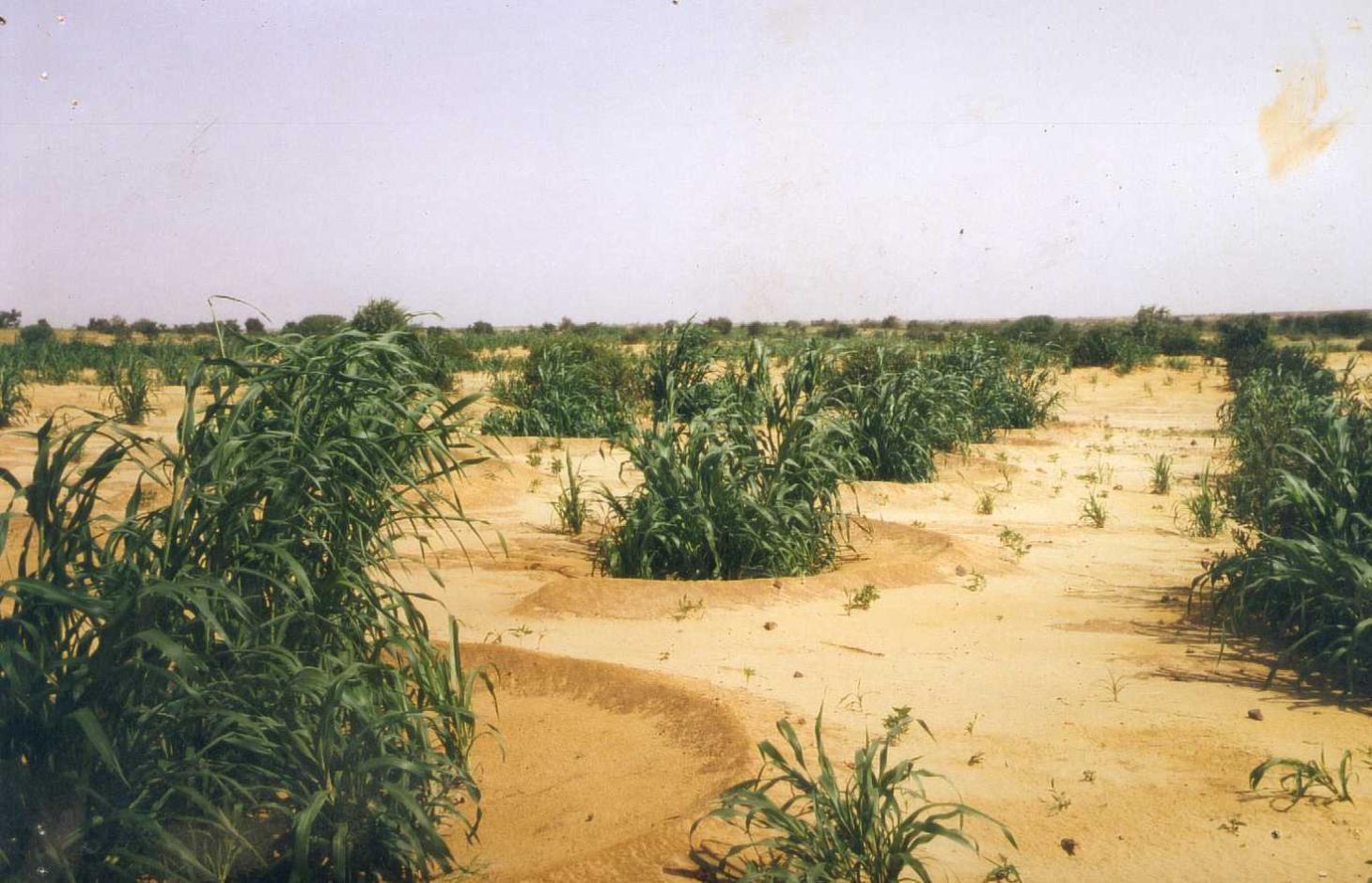
Semi-circular bunds are used to rehabilitate degraded, denuded and hardened land for crop growing, grazing or forestry.
2.2 Descripción detallada de la Tecnología
Descripción:
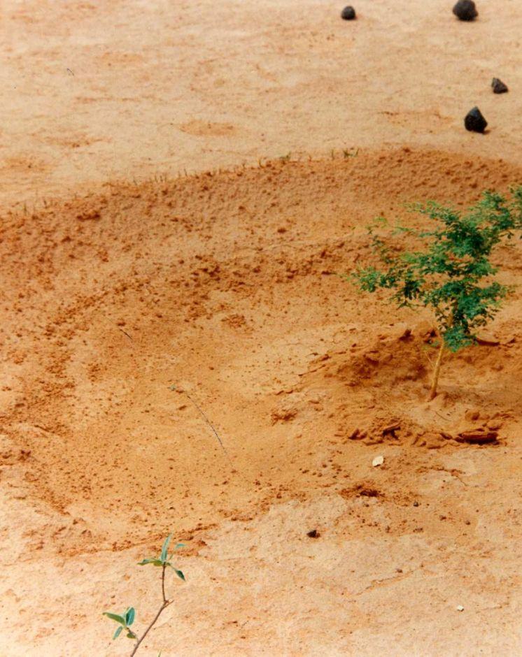
This technique involves building low embankments with compacted earth or stones in the form of a semi-circle with the opening perpendicular to the flow of water and arranged in staggered rows. They are constructed on gently to moderately sloping pediments and plateau areas in order to rehabilitate areas that are degraded, denuded and/or affected by soil crusting.
Depending on their purpose, the areas inside the semi-circular bunds, enriched with organic fertiliser, are used for growing cereals (crop crescents) and for planting trees, bushes and/or grasses (forestry and pastoral crescents). Semi-circular bunds slow down and capture runoff, providing the plants inside them with the water they need. They therefore reduce the loss of water and the fertile layers of the soil. This is particularly advantageous when rain is scarce, as the semi-circular bunds channel water towards the plants, increasing the moisture available to them. In the medium term, rich sediment builds up behind the semi-circular bunds, which helps to protect and restore the land. The bunds ensure that the manure placed around the plants inside them is not washed away by heavy rains, and the ridge of the bund protects young plants from the wind and wind erosion. When they are used for reforestation, they increase the rate of survival of the trees planted in them. Cropland bunds enable crops to survive dry spells. Earthen bunds are not, however, suitable in a scenario with heavy rainfall. They do not allow water to filter through, which can result in the soil inside them becoming waterlogged and the plants being flooded. This can lower yields in the case of crops that do not tolerate excess water. In such conditions, stone bunds are preferable.
To establish semi-circular bunds on cropland, the following activities are required: marking out the contour line, laying out the lines of the semi-circular bunds in staggered rows, digging the microcatchment, forming the ridge downhill of the microcatchment, applying organic fertiliser (around 1 t per ha per year).
To establish semi-circular bunds on forestland the same steps are required, however instead of applying fertilizer, other steps include digging the holes, planting the trees, and sowing grass on the ridges. The earthen ridges around cropland bunds need to be rebuilt each year. It is recommended that the ridges of forest/rangeland bunds be maintained each year and raised if overflowing has occurred. Forest/rangeland sites should be protected from grazing animals in the first two to three years, until the vegetation is well established. This requires good community organisation. After dry years, forest/rangeland semi-circular bunds may have to be re-sown with grasses and replanted with trees.
The Sahel is a region where the population has always faced a high degree of climate variability, manifested both in terms of time (unexpected dry spells can occur during the rainy season) and in terms of space (rainfall can vary greatly from one area to another). The population is mainly composed of small farmers and livestock keepers.
Over the last two decades, the effects of climate change have exacerbated the already difficult conditions. Accord¬ing to projections made by climatologists, the Sahel will experience a rise in temperatures combined with highly variable rainfall and an increase in extreme weather events. The Soil and Water conservation and rehabilitation techniques have helped people in the Sahel to manage their ecosystems more effectively and improve their productive land. As a result, communities are better prepared to cope with environmental changes (changes in the climate, land degradation, etc.) and the im¬pact of shocks, particularly droughts.
2.3 Fotografías de la Tecnología
Galería de medios
2.5 País/ región/ lugares donde la Tecnología fue aplicada y que se hallan comprendidos por esta evaluación
País:
Níger
Región/ Estado/ Provincia:
Niger, Burkina Faso, Chad
Especifique más el lugar :
Regions of Tillabéri, Filingué, Ouallam, Téra and Tahuoa in Niger; Bam region in Burkina Faso
Especifique la difusión de la Tecnología:
- distribuida parejamente sobre un área
Si se desconoce el área precisa, indique el área aproximada cubierta:
- 10-100 km2
Comentarios:
Also implemented in Burkina Faso and Chad
Regions of Tillabéri, Filingué, Ouallam, Téra and Tahuoa in Niger; Bam region in Burkina Faso
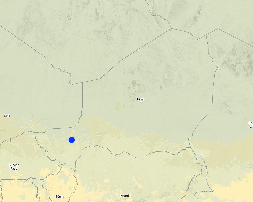
Map
×2.6 Fecha de la implementación
Si no se conoce el año preciso, indique la fecha aproximada:
- 10-50 años atrás
2.7 Introducción de la Tecnología
Especifique cómo se introdujo la Tecnología:
- mediante proyectos/ intervenciones externas
Comentarios (tipo de proyecto, etc.):
developed, implemented and disseminated as part of projects and programmes undertaken from the 1980s onwards to combat desertification and improve natural resource management. Implemented by GIZ (German Federal Enterprise for International Cooperation), PDRT (Projet de développement rural de Tahoua - Tahoua Rural Development Project), PASP (Projet de protection intégrée des ressources agro-sylvo-pastorales Tillabéri-Nord - Project for the Integrated Protection of Agricultural, Forest and Rangeland Resources in Tillabéri-Nord)
3. Clasificación de la Tecnología MST
3.1 Propósito(s) principal(es) de la Tecnología MST
- reducir, prevenir, restaurar la degradación del suelo
3.2 Tipo(s) actuales de uso de la tierra donde se aplica la Tecnología

Tierras cultivadas
- Cosecha anual
Número de temporadas de cultivo por año:
- 1
Especifique:
Longest growing period in days: 120, Longest growing period from month to month: August to October

Bosques
- Bosques/ zonas boscosas (semi) naturales
Bosques/ zonas boscosas (semi-) naturales: Especifique tipo de manejo:
- Tala selectiva
Productos y servicios:
- Madera
- Leña
- Frutos y nueces
- Otros productos forestales
- Pastoreo/ ramoneo
Comentarios:
Major land use problems (compiler’s opinion): droughts, soil erosion, lack of water, surface runoff, soil crusting, unadapted land use methods, rapidly growing population increasing pressure on land, reduced or abandoned fallow periods, soil erosion, insecure access to land.
Cut-and-carry/ zero grazing, Improved pasture, agropastolralism
Livestock density: 1-10 LU /km2
3.4 Provisión de agua
Provisión de agua para la tierra donde se aplica la Tecnología:
- mixta de secano – irrigada
3.5 Grupo MST al que pertenece la Tecnología
- agroforestería
- pastoralismo y manejo de tierras de pastoreo
3.6 Medidas MST que componen la Tecnología

medidas estructurales
- S2: Taludes, bancos
3.7 Principales tipos de degradación del suelo encarados con la Tecnología

erosión de suelos por agua
- Wt: pérdida de capa arable/ erosión de la superficie

deterioro químico del suelo
- Cn: reducción de la fertilidad y contenido reducido de la materia orgánica del suelo (no ocasionados por la erosión)

deterioro físico del suelo
- Pk: desmoronamiento y encostramiento

degradación del agua
- Ha: aridificación
Comentarios:
Main causes of degradation: soil management (Unadapted landuse methods, reduced or abandoned fallow periods), crop management (annual, perennial, tree/shrub) (Neglect of fallow periods and crop rotation), droughts (due to heat waves), population pressure (rapidly growing population, increasing pressure on land), land tenure (insecure access to land and collectively managed community land), poverty / wealth (very poor population)
Secondary causes of degradation: deforestation / removal of natural vegetation (incl. forest fires) (deforestation through overgrazing and fire wood collection), over-exploitation of vegetation for domestic use (firewood collection), overgrazing (cattle, sheep and goats), change in temperature (Climate change: heat waves), change of seasonal rainfall (more variable onset of rain), Heavy / extreme rainfall (intensity/amounts) (more variable and intensive rains), wind storms / dust storms (frequent storms), floods (due to intensive rain storms), labour availability (some migration of men to nearby cities), education, access to knowledge and support services (high level of illiteracy)
3.8 Prevención, reducción o restauración de la degradación del suelo
Especifique la meta de la Tecnología con relación a la degradación de la tierra:
- reducir la degradación del suelo
- restaurar/ rehabilitar tierra severamente degradada
4. Especificaciones técnicas, actividades de implementación, insumos y costos
4.1 Dibujo técnico de la Tecnología
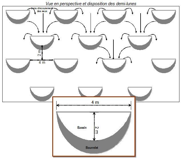
Especificaciones técnicas (relacionadas al dibujo técnico):
Source: Ministère du Développement Agricole Niger (without date): Recueil des fiches techniques en gestion des ressources naturelles et de productions agro-sylvo-pastorales.
Technical knowledge required for field staff / advisors: moderate
Technical knowledge required for land users: low
Main technical functions: control of dispersed runoff: retain / trap, control of dispersed runoff: impede / retard, control of concentrated runoff: retain / trap, control of concentrated runoff: impede / retard, increase of infiltration, increase / maintain water stored in soil, water harvesting / increase water supply, sediment retention / trapping, sediment harvesting
Secondary technical functions: improvement of surface structure (crusting, sealing), stabilisation of soil (eg by tree roots against land slides), increase in nutrient availability (supply, recycling,…), reduction in wind speed
Bund/ bank: semi-circular/V shaped trapezoidal
Depth of ditches/pits/dams (m): 0,15-0,20
Width of ditches/pits/dams (m): 2
Length of ditches/pits/dams (m): 4
4.2 Información general sobre el cálculo de insumos y costos
otra / moneda nacional (especifique):
CFA Franc
Si fuera relevante, indique la tasa de cambio de dólares americanos a la moneda local (ej. 1 U$ = 79.9 Reales Brasileros): 1 U$ =:
521,18
4.3 Actividades de establecimiento
| Actividad | Momento (estación) | |
|---|---|---|
| 1. | marking out the contour line | |
| 2. | laying out the lines of the semi-circular bunds in stag- gered rows | |
| 3. | digging the microcatchment | |
| 4. | forming the ridge downhill of the microcatchment | |
| 5. | applying organic fertiliser (around 1 t per ha per year) (only on cropland, this step is not required on forestland) | |
| 6. | digging the holes (only on forestland) | |
| 7. | planting the trees (only on forestland) | |
| 8. | sowing grass on the ridges (only on forestland) |
4.4 Costos e insumos necesarios para el establecimiento
| Especifique insumo | Unidad | Cantidad | Costos por unidad | Costos totales por insumo | % de los costos cubiertos por los usuarios de las tierras | |
|---|---|---|---|---|---|---|
| Mano de obra | labour | ha | 1,0 | 201,5 | 201,5 | 100,0 |
| Equipo | tools | ha | 1,0 | 17,3 | 17,3 | 100,0 |
| Costos totales para establecer la Tecnología | 218,8 | |||||
| Costos totales para establecer la Tecnología en USD | 0,42 | |||||
4.5 Actividades de establecimiento/ recurrentes
| Actividad | Momento/ frequencia | |
|---|---|---|
| 1. | The earthen ridges around cropland bunds need to be rebuilt each year | each year |
| 2. | the ridges of forest/rangeland bunds be maintained each year and raised if overflowing has occurred. | each year |
| 3. | After dry years, forest/rangeland semi-circular bunds may have to be re-sown with grasses and replanted with trees. | after dry years |
| 4. | Forest/rangeland sites should be protected from grazing animals in the first two to three years, until the vegetation is well established. | in the first two to three years |
4.6 Costos e insumos necesarios para actividades de mantenimiento/ recurrentes (por año)
Comentarios:
other costs for cropland semi-circular bunds: 10 cartloads of manure.
other costs for forestland semi-circular bunds:
• 625 tree seedlings
• 15 kg of grass seed
• cost of transporting 625 tree seedlings (2 cartloads)
• 120 seedlings to replace trees that die.
4.7 Factores más determinantes que afectan los costos:
Describa los factores más determinantes que afectan los costos:
In the case of forest/rangeland semi-circular bunds, the availability of tree and grass seeds and seedlings is a vital factor. In the PDRT and PASP projects in Niger, the villages had nurseries, and members of the village land manage- ment committees collected grass seeds from rangelands to sow in the semi-circular bunds.
5. Entorno natural y humano
5.1 Clima
Lluvia anual
- < 250 mm
- 251-500 mm
- 501-750 mm
- 751-1,000 mm
- 1,001-1,500 mm
- 1,501-2,000 mm
- 2,001-3,000 mm
- 3,001-4,000 mm
- > 4,000 mm
Zona agroclimática
- semi-árida
Thermal climate class: subtropics
5.2 Topografía
Pendientes en promedio:
- plana (0-2 %)
- ligera (3-5%)
- moderada (6-10%)
- ondulada (11-15%)
- accidentada (16-30%)
- empinada (31-60%)
- muy empinada (>60%)
Formaciones telúricas:
- meseta/ planicies
- cordilleras
- laderas montañosas
- laderas de cerro
- pies de monte
- fondo del valle
Zona altitudinal:
- 0-100 m s.n.m.
- 101-500 m s.n.m.
- 501-1,000 m s.n.m
- 1,001-1,500 m s.n.m
- 1,501-2,000 m s.n.m
- 2,001-2,500 m s.n.m
- 2,501-3,000 m s.n.m
- 3,001-4,000 m s.n.m
- > 4,000 m s.n.m
5.3 Suelos
Profundidad promedio del suelo:
- muy superficial (0-20 cm)
- superficial (21-50 cm)
- moderadamente profunda (51-80 cm)
- profunda (81-120 cm)
- muy profunda (>120 cm)
Textura del suelo (capa arable):
- mediana (limosa)
- fina/ pesada (arcilla)
Materia orgánica de capa arable:
- media (1-3%)
5.4 Disponibilidad y calidad de agua
Agua subterránea:
5-50 m
Disponibilidad de aguas superficiales:
mediana
Calidad de agua (sin tratar):
solo para uso agrícola (irrigación)
5.5 Biodiversidad
Diversidad de especies:
- baja
5.6 Las características de los usuarios de la tierra que aplican la Tecnología
Orientación del mercado del sistema de producción:
- subsistencia (autoprovisionamiento)
- mixta (subsistencia/ comercial)
Ingresos no agrarios:
- 10-50% de todo el ingreso
Nivel relativo de riqueza:
- muy pobre
- pobre
Nivel de mecanización:
- trabajo manual
- tracción animal
Género:
- hombres
Indique otras características relevantes de los usuarios de las tierras:
Population density: 10-50 persons/km2
Annual population growth: 3% - 4% (mostly poor households below poverty line).
Off-farm income specification: men migrate temporarily or permanently to cities for off-farm income, women and men seaonally carry out paid farm labour
5.7 Área promedio de la tierra usada por usuarios de tierra que aplican la Tecnología
- < 0.5 ha
- 0.5-1 ha
- 1-2 ha
- 2-5 ha
- 5-15 ha
- 15-50 ha
- 50-100 ha
- 100-500 ha
- 500-1,000 ha
- 1,000-10,000 ha
- > 10,000 ha
¿Esto se considera de pequeña, mediana o gran escala (refiriéndose al contexto local)?
- pequeña escala
5.8 Tenencia de tierra, uso de tierra y derechos de uso de agua
Tenencia de tierra:
- estado
- comunitaria/ aldea
Derechos de uso de tierra:
- acceso abierto (no organizado)
- comunitarios (organizado)
Derechos de uso de agua:
- acceso abierto (no organizado)
- comunitarios (organizado)
Comentarios:
traditional land use rights are prevailing. On fields individual land use rights, communal rights on pasture and forest land (collection of wood and other products (fruits, medicinal plants))
5.9 Acceso a servicios e infraestructura
salud:
- pobre
- moderado
- bueno
educación:
- pobre
- moderado
- bueno
asistencia técnica:
- pobre
- moderado
- bueno
empleo (ej. fuera de la granja):
- pobre
- moderado
- bueno
mercados:
- pobre
- moderado
- bueno
energía:
- pobre
- moderado
- bueno
caminos y transporte:
- pobre
- moderado
- bueno
agua potable y saneamiento:
- pobre
- moderado
- bueno
servicios financieros:
- pobre
- moderado
- bueno
6. Impactos y comentarios para concluir
6.1 Impactos in situ demostrados por la Tecnología
Impactos socioeconómicos
Producción
producción de cultivo
Comentarios/ especifique:
Cropland bunds constructed on abandoned farmland increase millet yields by 180 kg and straw yields by 400 kg per hectare per year
producción de forraje
producción animal
Comentarios/ especifique:
Forest/rangeland sites should be protected from grazing animals in the first two to three years, until the vegetation is well established. This requires good community organisation.
producción de madera
Comentarios/ especifique:
Sites improved with semi-circular bunds for reforestation produce one stere of wood per hectare per year after ten years. The value of this production can increase further from the fifth year onwards to around 850,000 CFA francs per hectare
Disponibilidad y calidad de agua
demanda de agua para irrigar
Ingreso y costos
carga de trabajo
Impactos socioculturales
seguridad alimentaria/ autosuficiencia
mitigación de conflicto
contribution to human well-being
Comentarios/ especifique:
notably increses production of food, fodder and forest products
Impactos ecológicos
Ciclo de agua/ escurrimiento de sedimento
cosecha/ recolección de agua
escurrimiento superficial
Suelo
humedad del suelo
pérdida de suelo
encostramiento/ sellado de suelo
ciclo/ recarga de nutrientes
Biodiversidad: vegetación, animales
diversidad vegetal
diversidad animal
Reducción de riesgos de desastres y riesgos climáticos
velocidad de viento
Otros impactos ecológicos
survival of planted trees
6.2 Impactos fuera del sitio demostrados por la Tecnología
disponibilidad de agua
inundaciones río abajo
colmatación río abajo
capacidad de amortiguación/ filtrado
daño a campos de vecinos
daños a infraestructura pública / privada
6.3 Exposición y sensibilidad de la Tecnología al cambio climático gradual y a extremos relacionados al clima/ desastres (desde la percepción de los usuarios de tierras)
Cambio climático gradual
Cambio climático gradual
| Estación | Incremento o reducción | ¿Cómo es que la tecnología soporta esto? | |
|---|---|---|---|
| temperatura anual | incrementó | bien |
Extremos (desastres) relacionados al clima
Desastres climatológicos:
| ¿Cómo es que la tecnología soporta esto? | |
|---|---|
| tormenta de lluvia local | no muy bien |
| tormenta de viento | bien |
Desastres climatológicos
| ¿Cómo es que la tecnología soporta esto? | |
|---|---|
| sequía | bien |
Desastres hidrológicos
| ¿Cómo es que la tecnología soporta esto? | |
|---|---|
| inundación general (río) | no muy bien |
Otras consecuencias relacionadas al clima
Otras consecuencias relacionadas al clima
| ¿Cómo es que la tecnología soporta esto? | |
|---|---|
| periodo reducido de crecimiento | no se sabe |
Comentarios:
Physical structures can be biologically stabilized through planting of grass, bushes or trees. Damages are generally small but need to be repaired quickly.
6.4 Análisis costo-beneficio
¿Cómo se comparan los beneficios con los costos de establecimiento (desde la perspectiva de los usuarios de tierra)?
Ingresos a corto plazo:
positivo
Ingresos a largo plazo:
muy positivo
¿Cómo se comparan los beneficios con los costos de mantenimiento/ recurrentes (desde la perspectiva de los usuarios de tierra)?
Ingresos a corto plazo:
positivo
Ingresos a largo plazo:
muy positivo
Comentarios:
Forest/rangeland sites should be protected from grazing animals in the first two to three years, until the vegetation is well established. Semi-circular bunds on forest/rangeland can achieve a remarkable regreening of the environment and promote biodiversity. Cropland bunds constructed on abandoned farmland increase millet yields by 180 kg and straw yields by 400 kg per hectare per year. Sites improved with semi-circular bunds for reforestation produce one stere of wood per hectare per year after ten years. The value of this production can increase further from the fifth year onwards to around 850,000 CFA francs per hectare.
6.5 Adopción de la Tecnología
- > 50%
De todos quienes adoptaron la Tecnología, ¿cuántos lo hicieron espontáneamente, por ej. sin recibir nada de incentivos/ materiales:
- 11-50%
Comentarios:
60% of land user families have adopted the Technology with external material support
The techniques were implemented with food for work in the 1990s to 2000. Between 2000 and 2012 the work provided by land users was not compensated. Only small equipment and transportation were provided for free.
40% of land user families have adopted the Technology without any external material support. Some adoption (without support by the project) has been observed in some places. The level of replication is however limited to locations where stones are available nearby. Otherwise transportation becomes a problem.
There is a little trend towards spontaneous adoption of the Technology. Semi-circular bunds are applied for example in Niger, Burkina Faso, and Chad.
Some adoption (without support by the project) has been observed in some places. The level of replication is however limited to locations where stones are available nearby. Otherwise transportation becomes a problem.
6.7 Fuerzas/ ventajas/ oportunidades de la Tecnología
| Fuerzas/ ventajas/ oportunidades desde la perspectiva del compilador o de otra persona de referencia clave |
|---|
| Semi-circular bunds slow down runoff and enable the harvested water to be used to good effect. Soil moisture increases and the loss of fertile layers of the soil is reduced. |
| Cropland bunds enable crops to survive dry spells. On abandoned farmland millet yields may increase by 180 kg and straw yields by 400 kg per hectare per year. |
| Semi-circular bunds on forest/rangeland can achieve a remarkable regreening of the environment and promote biodiversity. When they are used for reforestation, they increase the rate of survival of the trees planted in them. Sites improved with semi-circular bunds produce one stere of wood per hectare per year after ten years. The value of this production can increase further from the fifth year onwards to around 850,000 CFA francs per hectare. |
| In the medium term, rich sediment builds up behind the semi-circular bunds, which helps to protect and restore the land. |
6.8 Debilidades/ desventajas/ riesgos de la Tecnología y formas de sobreponerse a ellos
| Debilidades/ desventajas/ riesgos desde la perspectiva del compilador o de otra persona de referencia clave | ¿Cómo sobreponerse a ellas? |
|---|---|
| In the event of heavy runoff, a considerable amount of water accumulates inside the semi-circular bunds, and the ridges must be strong enough to withstand its weight. If the water overflows, it can create gaps in the bunds or cut out channels around the sides of them. | The land must be hoed each year. |
| At some sites, rainwater infiltration increases in the first year after the semi-circular bunds have been constructed, but if the land is not hoed, this effect declines considerably in successive years. | In such conditions, stone bunds are preferable. |
| Earthen bunds are not suitable in a scenario with heavy rainfall. They do not allow water to filter through, which can result in the soil inside them becoming waterlogged and the plants being flooded. This can lower yields in the case of crops that do not tolerate excess water (e.g. millet). | |
| Animal production may be reduced because forest/rangeland sites should be protected from grazing animals in the first two to three years, until the vegetation is well established. | |
| Labour-intensive work |
7. Referencias y vínculos
7.1 Métodos/ fuentes de información
- visitas de campo, encuestas de campo
- entrevistas con usuarios de tierras
¿Cuándo se compilaron los datos (en el campo)?
01/07/2012
7.2 Vínculos a las publicaciones disponibles
Título, autor, año, ISBN:
Good Practices in Soil and Water Conservation. A contribution to adaptation and farmers´ resilience towards climate change in the Sahel. Published by GIZ in 2012.
¿Dónde se halla disponible? ¿Costo?
http://agriwaterpedia.info/wiki/Main_Page
Vínculos y módulos
Expandir todo Colapsar todosVínculos
No hay vínculos
Módulos
No se hallaron módulos