Gradual development of bench terraces from contour ditches [Tayikistán]
- Creación:
- Actualización:
- Compilador: Manuchehr Rakhmatdzhonov
- Editor: –
- Revisores: Laura Ebneter, Alexandra Gavilano, Fabian Ottiger, Joana Eichenberger
Ташакули тадричии терассахо тавассути чуйборхои контури
technologies_1043 - Tayikistán
- Resumen completo en PDF
- Resumen completo en PDF para imprimir
- Resumen completo en el navegador
- Resumen completo (sin formato)
- Gradual development of bench terraces from contour ditches: 20 de agosto de 2019 (inactive)
- Gradual development of bench terraces from contour ditches: 2 de noviembre de 2021 (public)
- Gradual development of bench terraces from contour ditches: 22 de julio de 2017 (inactive)
- Gradual development of bench terraces from contour ditches: 2 de junio de 2017 (inactive)
- Gradual development of bench terraces from contour ditches: 31 de mayo de 2017 (inactive)
- Gradual development of bench terraces from contour ditches: 27 de diciembre de 2016 (inactive)
Visualizar secciones
Expandir todo Colapsar todos1. Información general
1.2 Detalles de contacto de las personas de referencia e instituciones involucradas en la evaluación y la documentación de la Tecnología
hafizova tahmina
Deutsche Welthungerhilfe, Tajikistan
Tayikistán
Nombre del proyecto que financió la documentación/ evaluación de la Tecnología (si fuera relevante)
Pilot Program for Climate Resilience, Tajikistan (WB / PPCR)Nombre de la(s) institución(es) que facilitaron la documentación/ evaluación de la Tecnología (si fuera relevante)
Welthungerhilfe (Welthungerhilfe) - Tayikistán1.3 Condiciones referidas al uso de datos documentados mediante WOCAT
El compilador y la/s persona(s) de referencia claves aceptan las condiciones acerca del uso de los datos documentados mediante WOCAT:
Sí
1.5 Referencia al (los) Cuestionario(s) de Enfoques MST (documentados usando WOCAT)
Facilitation of micro-watershed management for farmers [Tayikistán]
Relying on integrated watershed management principles, farmers were assisted by the project to implement soil and water conservation measures in a microwatershed.
- Compilador: Manuchehr Rakhmatdzhonov
2. Descripción de la Tecnología MST
2.1 Breve descripción de la Tecnología
Definición de la Tecnología:
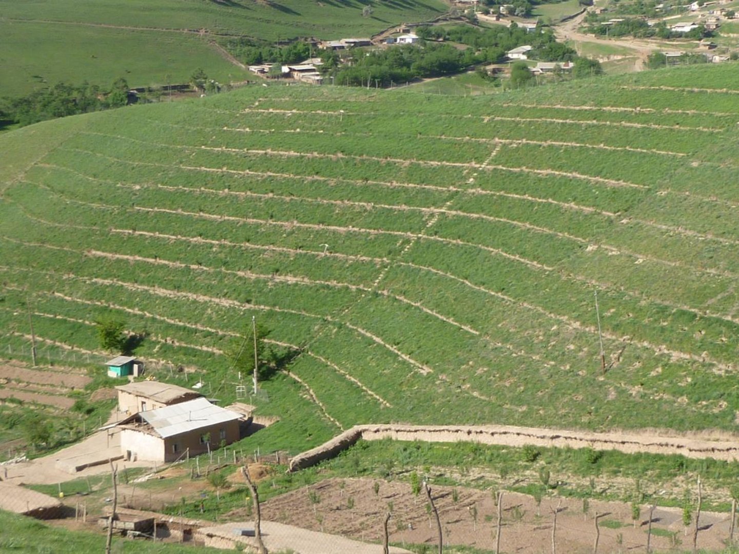
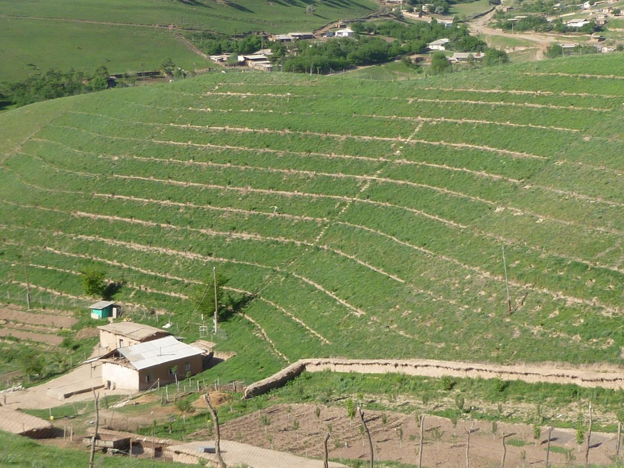
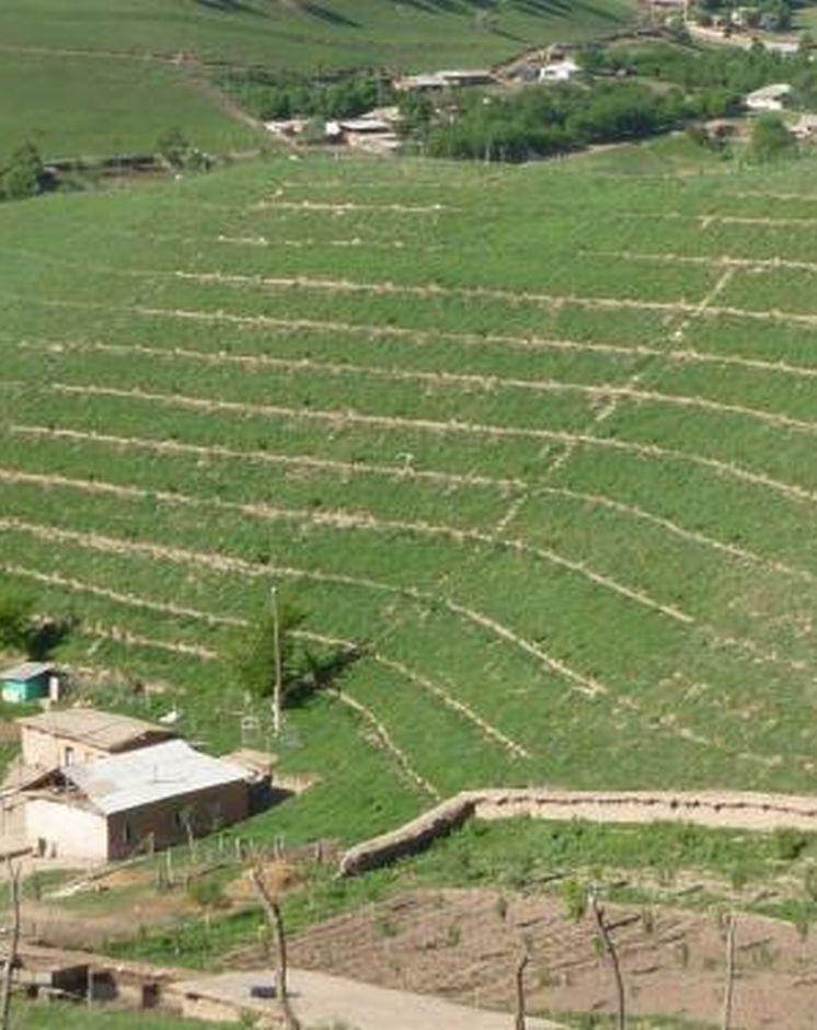
Use of the SLM technology facilitates the development of bench terraces from contour channels by gradually removing soil material up the slope for an estimated 5 years until the terraces on the slope reach a desired width of 1.2 m.
2.2 Descripción detallada de la Tecnología
Descripción:
The SLM technology is thought to stop water run-off resulting in the prevention of damage to the top soil on steep slopes. This enables better distribution and infiltration of water into the soil. A complementing live fence, along with a metal net along the perimeter aim to stop livestock grazing. Contour ditches are planted in intervals with fruit trees, and the live fence is made of a combination of fire wood, trees and bushes. This combination makes possible the establishment of an agro forestry system on a slope in an area with limited irrigation using making use of the natural rainfall.
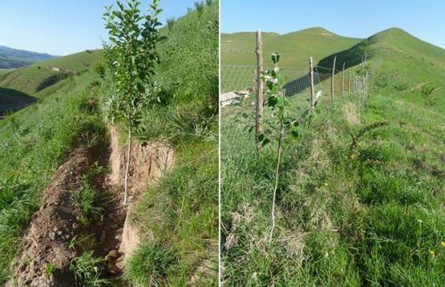
Details: 1. Ditches are dug out along the contour lines drawn by an "A" frame on the slope. 2. Seedlings are planted in 5 metre intervals, positioned right in the middle of the ditch. 3. The back wall behind each tree (upslope) has a half moon cutting to enable an even water/moisture supply. 4. The ditches are barriered with "septas" between two trees to trap water in the individual sections. 5. Horizontally across the ditches, the tree species vary, but vertically are homogeneous. 6. The strips between ditches are left free to enable natural grass to grow. 7. The residual soil material is mounted in front of the ditches in piles the width of a shovel. 8. The complementing perimeter live fence and metal net (1.5m height) is supported by wooden poles made of Acacia trees. (Assumed life span of poles is 25 years). 9. Improvised drip irrigation with 5 litre plastic bottles is used together with mulch coverage beneath the trees. 10. Species composition: apple, cherry, apricot, grape, walnut, pomegranate. In the garden; species of Acacia, Ailantus, dogroses and willow act as a live fence.
Purpose of the Technology: The aim of this system is to significantly reduce the water run-off that removes the top soil, and to subsequently prevent water erosion, and the formation/development of gullies. This can be achieved through the following methods; conserving the available resources and using them more efficiently, prevention overgrazing and improving the natural soil cover, as well as changing the type of land management towards a more sustainable and profitable one.
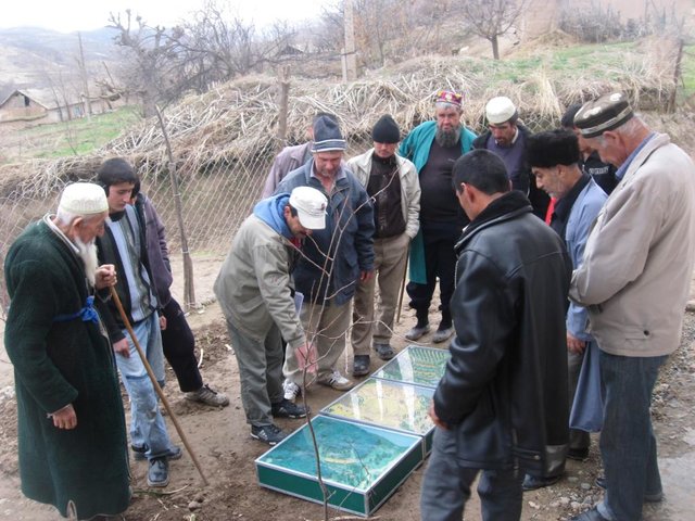
Establishment / maintenance activities and inputs: The plot was established on one side of a micro watershed. In mid February the contour lines were identified using an “A” frame. Digging of contour ditches then took until late February. The material was accumulated down the slope in deposits the width of a shovel to build a riser. At the beginning of March all the fruit tree seedlings were planted in the middle of the ditches. Perimeter fencing was constructed and live fence plants were planted up until late March. In May, the grass around the trees was cut and used for mulching beneath the trees. During June and July in the first year the plants needed watering 3 times a week which was done using a drip irrigation system with 5 litre plastic bottles. To help prevent the water heating and evaporating, the bottles were left under the mulch cover. Mulching and irrigation are repeated every dry and hot season. Every spring, the soil material is removed alongside the inner wall of the ditch just taking an amount that equals the width of a shovel, and accumulated down the slope to extend the riser. Materials required include: (1) Ditches: hand tools, stakes, rope, “A” frame, (2) Live fence: seedlings of Acacia, Ailantus, willow and dog rose, (3) Fencing: metal net, wooden poles, metal wire, (4) Cow dung, lime suspension, straw, mulch, plastic bottles.
Natural / human environment: The watershed can be characterised as follows: Hydrology - surface water is available only at times of rain and snow melt, this can be used for irrigation only. No sources of potable water exist. Soils are of loess type, as generally characteristic to the whole area. Flora - natural grasses prevail in the micro watershed, 9 species could be identified. Natural bushes and trees were completely removed due to high demand for fuelwood. Cultivation of rare tree varieties and household gardening was practiced in advance of the project. Fauna - Wild animals are often still seen such as turtles, lizards and snakes. Farm animals - mixed breeds of cattle, sheep and goats are very important. The households in this micro watershed area own almost 350 animals. The majority of these are kept for the summer season in adjacent pastures. The micro watershed was first inhabited in early 2000. Five households were established with a total of around 40 inhabitants. Family heads tend to be in their early 40s. Families have 7 to 9 members, including 5 to 7 children. All are of Tajik ethnicity, and Muslim, open to secular values. Of these 5 households, only 4 households have adopted the SLM technology. The fifth household only decided to join the project after witnessing their neighbour’s positive experiences. Both spouses tended to be involved in the activities. Both men and women took part in the training sessions and orientation meeting. However, it is likely that most decisions were made by the men, after the women had shared their ideas. Work load: providing the external inputs, construction and the heavy manual labour were done by the men. Maintenance work: watering, mulching and grass cutting was shared between men and women. Digging and fencing were performed in "hashars" - community labour groups. As women spend more time at home working within their households, they tend to perform more maintenance work on the plot compared to men. Other activities away from the farms are important to the family budget providing a means of extra income. This often includes men’s long term migration to Russia to find work.
2.3 Fotografías de la Tecnología
Galería de medios
2.5 País/ región/ lugares donde la Tecnología fue aplicada y que se hallan comprendidos por esta evaluación
País:
Tayikistán
Región/ Estado/ Provincia:
Tajikistan, Khatlon
Especifique más el lugar :
Baljuvon, Khirob
Comentarios:
Boundary points of the Technology area: North - 38.284233°N 69.639420°E
South - 38.278485°N 69.639555°E
East - 38.281854°N 69.641276°E
South - 38.281250°N 69.638009°E
Total area covered by the SLM Technology is 0.112 km2.
The application of the SLM technology is planned for the whole micro watershed which has a total area of 0.112 km2. Currently it has been impemented in 0.07km2 of this watershed.
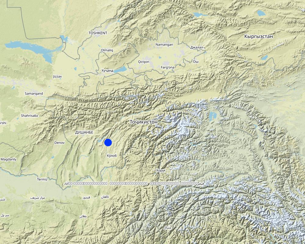
Map
×2.6 Fecha de la implementación
Si no se conoce el año preciso, indique la fecha aproximada:
- hace menos de 10 años (recientemente)
2.7 Introducción de la Tecnología
Especifique cómo se introdujo la Tecnología:
- mediante proyectos/ intervenciones externas
3. Clasificación de la Tecnología MST
3.2 Tipo(s) actuales de uso de la tierra donde se aplica la Tecnología

Tierras cultivadas
- Cosecha anual
- Cultivos perennes (no leñosos)
- Cosecha de árboles y arbustos
Cosechas anuales - Especifique cultivos:
- cultivos para forraje - alfalfa
- espercet
Cultivos perennes (no maderables) - Especifique cultivos:
- bayas
Cultivos de matorrales y arbustos - Especifique cultivos:
- uvas
- frutas de hueso (durazno, albaricoque, cerezos, ciruelas, etc)
- frutos secos (castañas, pistachos, nuez, almendras, etc.)
- frutas de pepita (manzanas, peras, membrillo, etc.)
- Ailantus, Acacia, dog rose, willow, poplar
Número de temporadas de cultivo por año:
- 1
Especifique:
Longest growing period in days: 180Longest growing period from month to month: March - August
¿Se practica el intercultivo?
Sí
Si respondió que sí, especifique qué cultivos son intercultivados:
tomatoes, paprica

Tierra de pastoreo
Pastoreo extenso:
- Nomadismo
- Pastoralismo semi-nómada
Pastoreo intensivo/ producción de forraje:
- Cortar y llevar/ cero pastoreo
- Livestock density (if relevant): 50-100 LU /km2

Bosques
- Bosques/ zonas boscosas (semi) naturales
Productos y servicios:
- Madera
- Leña
- Frutos y nueces
- Otros productos forestales
- Pastoreo/ ramoneo
- Conservación/ Protección de la naturaleza
Comentarios:
Major land use problems (compiler’s opinion): Implementation of land tenure rights at a local level was also a major barrier.
Major land use problems (land users’ perception): There is a soil and water conservation project in place to manage water runoff, soil erosion and gully formation. Low land productivity only allows for wheat production with long fallow periods. Improper pasture management has led to overall overgrazing.
Nomadism: animals taken to summer pastures
Semi-nomadism / pastoralism: animal graze around villages
Ranching: no practice
Cut-and-carry/ zero grazing: almost extinct
Improved pasture: no practice at all
Clear felling of (semi-)natural forests: No selection in times of electricity cuts in winter season.
Forest products and services: timber, fuelwood, fruits and nuts, grazing / browsing, other forest products / uses (honey, medical, etc.), nature conservation / protection
Future (final) land use (after implementation of SLM Technology): Mixed: Mf: Agroforestry
Constraints of infrastructure network (roads, railways, pipe lines, power lines): no irrigation network, heavy transports costs
3.3 ¿Cambió el uso de tierras debido a la implementación de la Tecnología?
¿Cambió el uso de tierras debido a la implementación de la Tecnología?
- Sí (Por favor responda las preguntas de abajo referidas al uso de la tierra antes de implementar la Tecnología)
Mezcla de tipos de uso de tierras dentro de la misma unidad de tierras: :
Sí
Especifique el uso combinado de tierras (cultivos/ pastoreo/ árboles):
- Agroforestería
Tierra de pastoreo

asentamientos, infraestructura
- Tráfico: caminos, rieles
- Energía: gasoductos, líneas eléctricas
Comentarios:
Grazing land: Ge: Extensive grazing land
3.4 Provisión de agua
Comentarios:
Water supply: rainfed, mixed rainfed - irrigated, rainfed
Water supply: post-flooding
post-flooding
3.6 Medidas MST que componen la Tecnología

medidas agronómicas
- A1: vegetación/ cubierta del suelo
- A2: materia orgánica/ fertilidad del suelo
- A3: Tratamiento de superficie del suelo
A3: Diferencie sistemas de labranza:
A 3.1: Sin labranza

medidas vegetativas
- V1: Cubierta de árboles y arbustos

medidas estructurales
- S1: Terrazas

medidas de manejo
- M1: Cambio de tipo de uso de la tierra
Comentarios:
Main measures: agronomic measures, vegetative measures, structural measures, management measures
Type of agronomic measures: mixed cropping / intercropping, contour planting / strip cropping, mulching, legume inter-planting, manure / compost / residues, zero tillage / no-till, pits
Type of vegetative measures: aligned: -contour, aligned: -graded strips *<sup>3</sup>, aligned: -along boundary
3.7 Principales tipos de degradación del suelo encarados con la Tecnología

erosión de suelos por agua
- Wt: pérdida de capa arable/ erosión de la superficie
- Wg: erosión en cárcavas

degradación biológica
- Bc: reducción de la cobertura vegetal del suelo
Comentarios:
Main causes of degradation: soil management (Tillage on steep slope >35%.), deforestation / removal of natural vegetation (incl. forest fires) (Natural tree and shrubs removed completely.), over-exploitation of vegetation for domestic use, overgrazing (Stocking rates do exceed the standards in multiple times), disturbance of water cycle (infiltration / runoff) (Run-off is induced by maximum removal of vegetation cover.), land tenure (Unclear land right situation induces irresponsible attitudes.), inputs and infrastructure: (roads, markets, distribution of water points, other, …) (Very limited infrastructure development, vital infrastructure points are a long distance away.)
Secondary causes of degradation: Heavy / extreme rainfall (intensity/amounts) (Induces gully formation and mass movement.), droughts (If vegetation is dry then less soil cover is provided.), other natural causes (avalanches, volcanic eruptions, mud flows, highly susceptible natural resources, extreme topography, etc.) specify (The gradient is over 30%.), population pressure (Large family sizes, and high growth rates causes increased need for food and living space in the area.), poverty / wealth (Very limited financial power to develop the land.), labour availability (Though cheap labour is available, it takes much effort to organise communities to work together for SLM activities.), education, access to knowledge and support services (Basic schooling of children, no state provided extension or training after school age.), war and conflicts (The after-effects of recent civil war still have some influence.), governance / institutional (Communist attitudes still persist, very slow institutional development.)
3.8 Prevención, reducción o restauración de la degradación del suelo
Comentarios:
Main goals: prevention of land degradation
Secondary goals: mitigation / reduction of land degradation, rehabilitation / reclamation of denuded land
4. Especificaciones técnicas, actividades de implementación, insumos y costos
4.1 Dibujo técnico de la Tecnología
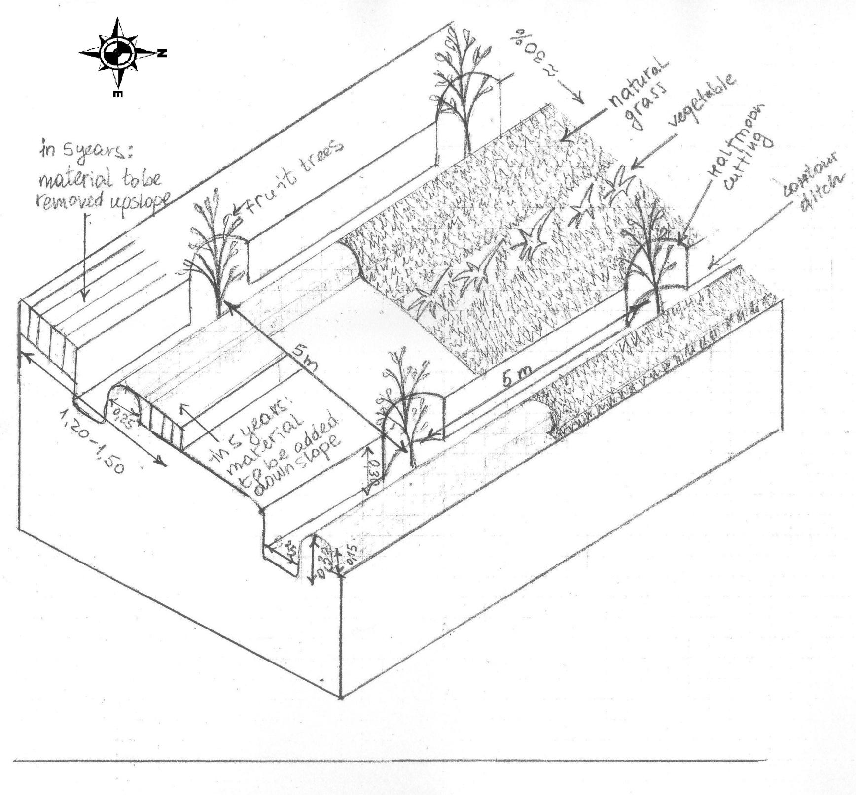
Especificaciones técnicas (relacionadas al dibujo técnico):
The drawing shows the contour ditches on a slope with a 25 - 30 % steepness. The gradient is 3-5%.
Vertically, the contour ditches are spaced at 5 m intervals. The upper left part of the drawing shows how the material on the slope will be removed in portions during the five years to create a levelled terrace. The ditches are planted with fruit trees, and strips of natural grass cover the space between the ditches. In the middle line of the strips in the bottom part of the plot the farmer has grown vegetables.
Location: Khirob village. Baljuvon/ Khatlon/ Tajikistan
Date: 06.05.2011
Technical knowledge required for field staff / advisors: high (Specific knowledge needed in the issues of integrated watershed management and technology.)
Technical knowledge required for land users: moderate (Training needed in terms of technology, planning and implementation of activities.)
Main technical functions: control of dispersed runoff: retain / trap, reduction of slope angle, increase of infiltration, promotion of vegetation species and varieties (quality, eg palatable fodder)
Secondary technical functions: control of dispersed runoff: impede / retard, improvement of ground cover, increase of surface roughness, improvement of topsoil structure (compaction), stabilisation of soil (eg by tree roots against land slides), increase / maintain water stored in soil, water harvesting / increase water supply, water spreading, increase of biomass (quantity), spatial arrangement and diversification of land use
Mixed cropping / intercropping
Material/ species: Growing a few tomatoes and paprica on the bottom strips.
Quantity/ density: 4plants m2
Remarks: Down slope alongside the ditches.
Contour planting / strip cropping
Material/ species: Wild vegetation is left to grow.
Quantity/ density: very dense
Remarks: Over 9 species counted on the plot all palatable, cut for hay and mulch.
Mulching
Material/ species: Mulching from natural grass, over 9 species.
Remarks: Ditches and trees covered beneath.
Legume inter-planting
Quantity/ density: 2 raisers.
Remarks: As a test to cover raiser surface.
Manure / compost / residues
Material/ species: Cattle dung suspended in water.
Quantity/ density: Once.
Remarks: Applied while planting the trees.
Zero tillage / no-till
Material/ species: No tillage for intercropping completed.
Pits
Material/ species: Pits were dug to plant seedlings.
Aligned: -contour
Vegetative material: T : trees / shrubs
Number of plants per (ha): 400
Vertical interval between rows / strips / blocks (m): 5
Spacing between rows / strips / blocks (m): 5
Vertical interval within rows / strips / blocks (m): 5
Width within rows / strips / blocks (m): 5
Aligned: -graded strips
Vegetative material: G : grass
Number of plants per (ha): na
Vertical interval between rows / strips / blocks (m): 1
Spacing between rows / strips / blocks (m): 3
Aligned: -along boundary
Vegetative material: T : trees / shrubs
Number of plants per (ha): 400
Spacing between rows / strips / blocks (m): 1
Trees/ shrubs species: Ailantus, Acacia, dog rose, willow, poplar
Fruit trees / shrubs species: Apple, grape, pear, apricot, cherry, pomegranate, mulberry, walnut
Perennial crops species: little alfalfa and espercet
Grass species: 9 naturally growing species
Slope (which determines the spacing indicated above): 30.00%
Gradient along the rows / strips: 25.00%
Retention/infiltration ditch/pit, sediment/sand trap
Vertical interval between structures (m): 5
Spacing between structures (m): 5
Depth of ditches/pits/dams (m): 0.3
Width of ditches/pits/dams (m): 0.25
Height of bunds/banks/others (m): 0.15
Width of bunds/banks/others (m): 0.25
Terrace: bench level
Vertical interval between structures (m): 3.50-3.80
Height of bunds/banks/others (m): 0.25
Width of bunds/banks/others (m): 1.20-1.50
Construction material (earth): the earth is removed upslope and added downslope to the front bank (raiser)
Slope (which determines the spacing indicated above): 25-30%
Lateral gradient along the structure: 3-5%
Vegetation is used for stabilisation of structures.
Change of land use type: Communal pasture land was turned into an agroforestry system
Change of land use practices / intensity level: Self subsistance, market orientated agroforestry system
Layout change according to natural and human environment: Along the contour lines of the slope
Major change in timing of activities: Major seasonal activities in three seasons: spring agronomic and vegetative measures, summer and autumn yield harvesting, clearing the branches
Autor:
Manuchehr Rakhmatdzhonov, 16, Firdavsi street, 734003 Dushanbe
4.2 Información general sobre el cálculo de insumos y costos
otra / moneda nacional (especifique):
Somoni
Si fuera relevante, indique la tasa de cambio de dólares americanos a la moneda local (ej. 1 U$ = 79.9 Reales Brasileros): 1 U$ =:
4,5
Indique el costo promedio del salario de trabajo contratado por día:
5.00
4.3 Actividades de establecimiento
| Actividad | Momento (estación) | |
|---|---|---|
| 1. | Planting seedlings in contour ditches | February-March |
| 2. | Planting seedlings and bushes along the perimeter | March |
| 3. | Cost of seedlings: frutiouse and firewood trees | February -March |
| 4. | Gradual terracing by Broadening the ditch onslope and extending the raiser downslope | every spring during 5 years |
| 5. | Membership fees | |
| 6. | Attending the training | |
| 7. | Management of staff | |
| 8. | Taxes | |
| 9. | Membership fees | |
| 10. | None |
4.4 Costos e insumos necesarios para el establecimiento
| Especifique insumo | Unidad | Cantidad | Costos por unidad | Costos totales por insumo | % de los costos cubiertos por los usuarios de las tierras | |
|---|---|---|---|---|---|---|
| Mano de obra | Labour | 1,0 | 355,0 | 355,0 | 100,0 | |
| Mano de obra | Mulching | 1,0 | 4,5 | 4,5 | 100,0 | |
| Mano de obra | Planting seedlings in contour ditches | person days | 20,0 | 4,4 | 88,0 | 100,0 |
| Mano de obra | Planting seedlings and bushes along the perimeter | person days | 10,0 | 4,4 | 44,0 | 100,0 |
| Equipo | Set of shovels, hoes, picks | Set | 1,0 | 66,0 | 66,0 | 50,0 |
| Material para plantas | mulching | 1,0 | 4,5 | 4,5 | 100,0 | |
| Material para plantas | seedlings | 1,0 | 333,0 | 333,0 | 50,0 | |
| Material para plantas | Seedlings: frutiouse and firewood trees | ha | 500,0 | 0,666 | 333,0 | 50,0 |
| Material de construcción | Wood frame | Piece | 1,0 | 3,0 | 3,0 | 100,0 |
| Otros | Labour: Gradual terracing by Broadening the ditch onslope and extending the raiser downslope | person days | 150,0 | 0,68 | 102,0 | 100,0 |
| Costos totales para establecer la Tecnología | 1333,0 | |||||
| Costos totales para establecer la Tecnología en USD | 296,22 | |||||
Comentarios:
Number of parties sharing for Mulching, tools, labour and a wood frame: 5
Lifespan for tools and wood frame: 5 years
Life span of mulching: 3 years
4.5 Actividades de establecimiento/ recurrentes
| Actividad | Momento/ frequencia | |
|---|---|---|
| 1. | Drip irrigation with plastic bottles | first 3 years |
| 2. | Mulching | once a year |
| 3. | Shaping the trees, cutting branches | Autumn |
| 4. | Shaping the trees, cutting branches | Autumn |
| 5. | Grafting | March |
| 6. | Manuring | March |
| 7. | None | None |
4.6 Costos e insumos necesarios para actividades de mantenimiento/ recurrentes (por año)
| Especifique insumo | Unidad | Cantidad | Costos por unidad | Costos totales por insumo | % de los costos cubiertos por los usuarios de las tierras | |
|---|---|---|---|---|---|---|
| Mano de obra | Drip irrigation with plastic bottles | person days | 15,0 | 4,44 | 66,6 | 100,0 |
| Mano de obra | Mulching | person days | 5,0 | 4,44 | 22,2 | 100,0 |
| Mano de obra | Shaping the trees, cutting branches | person days | 5,0 | 4,44 | 22,2 | 100,0 |
| Mano de obra | Grafting | person days | 5,0 | 4,44 | 22,2 | 100,0 |
| Material para plantas | mulching | 1,0 | 22,0 | 22,0 | 100,0 | |
| Otros | Labour: Manuring | person days | 3,0 | 4,4 | 13,2 | 100,0 |
| Indique los costos totales para mantenecer la Tecnología | 168,4 | |||||
| Costos totales para mantener la Tecnología en USD | 37,42 | |||||
Comentarios:
Labour costs apply to the cultivation of the whole 7ha plot.
4.7 Factores más determinantes que afectan los costos:
Describa los factores más determinantes que afectan los costos:
The most affecting factors were the high cost inputs for construction material which usually has to be imported into the area: Fuel, metal nets for fencing, cement, etc.
5. Entorno natural y humano
5.1 Clima
Lluvia anual
- < 250 mm
- 251-500 mm
- 501-750 mm
- 751-1,000 mm
- 1,001-1,500 mm
- 1,501-2,000 mm
- 2,001-3,000 mm
- 3,001-4,000 mm
- > 4,000 mm
Especificaciones/ comentarios sobre la cantidad de lluvia:
Summer, >120 dry days
250-500 mm
Late summer, late autumn, rain prevails until the late autumn
500-750 mm
Late autumn mid spring, rain, snow.
750-1000 mm
avarage annual, usually up to 800mm
1000-1500 mm
not often, 1000mm heppen in single years
Zona agroclimática
- semi-árida
Thermal climate class: temperate. winters with possible extreme cold, warm summers, with hot spells in July August
5.2 Topografía
Pendientes en promedio:
- plana (0-2 %)
- ligera (3-5%)
- moderada (6-10%)
- ondulada (11-15%)
- accidentada (16-30%)
- empinada (31-60%)
- muy empinada (>60%)
Formaciones telúricas:
- meseta/ planicies
- cordilleras
- laderas montañosas
- laderas de cerro
- pies de monte
- fondo del valle
Zona altitudinal:
- 0-100 m s.n.m.
- 101-500 m s.n.m.
- 501-1,000 m s.n.m
- 1,001-1,500 m s.n.m
- 1,501-2,000 m s.n.m
- 2,001-2,500 m s.n.m
- 2,501-3,000 m s.n.m
- 3,001-4,000 m s.n.m
- > 4,000 m s.n.m
Indique si la Tecnología se aplica específicamente en:
- no relevante
Comentarios y especificaciones adicionales sobre topografía :
hilly area, located on the foot of Vakhsh mountain range; micro watersheds feeding the bigger watershed of the Kyzylsu river
5.3 Suelos
Profundidad promedio del suelo:
- muy superficial (0-20 cm)
- superficial (21-50 cm)
- moderadamente profunda (51-80 cm)
- profunda (81-120 cm)
- muy profunda (>120 cm)
Textura del suelo (capa arable):
- mediana (limosa)
Materia orgánica de capa arable:
- media (1-3%)
- baja (<1%)
5.4 Disponibilidad y calidad de agua
Agua subterránea:
5-50 m
Disponibilidad de aguas superficiales:
mediana
Calidad de agua (sin tratar):
solo para uso agrícola (irrigación)
5.5 Biodiversidad
Diversidad de especies:
- mediana
5.6 Las características de los usuarios de la tierra que aplican la Tecnología
Ingresos no agrarios:
- 10-50% de todo el ingreso
Nivel relativo de riqueza:
- muy pobre
- pobre
Individuos o grupos:
- individual/ doméstico
Género:
- hombres
Indique otras características relevantes de los usuarios de las tierras:
Land users applying the Technology are mainly common / average land users
Difference in the involvement of women and men: Very few women are trusted to run a farm or make decisions about land use. Usually women have taken leading roles only if the men leave the family for long term migration, or have died. Only 8 women in the whole district are farm owners out of the total of 350 existing farms.
Women's involvement and level of freedom given to them are influenced by existing patriarchal values, and in many areas women often remain unaware of their rights.
Population density: 10-50 persons/km2
Annual population growth: 1% - 2%
3% of the land users are very rich and own 20% of the land.
5% of the land users are rich and own 10% of the land.
10% of the land users are average wealthy and own 40% of the land.
60% of the land users are poor and own 20% of the land.
22% of the land users are poor and own 10% of the land.
Off-farm income specification: Complemented by salary from state job, NGO activity, transport service and construction work in capital town and other regions, labour migration to Russia.
Market orientation of production system: subsistence (self-supply), subsistence (self-supply), subsistence (self-supply), mixed (subsistence/ commercial, mixed (subsistence/ commercial, commercial/ market
5.7 Área promedio de la tierra usada por usuarios de tierra que aplican la Tecnología
- < 0.5 ha
- 0.5-1 ha
- 1-2 ha
- 2-5 ha
- 5-15 ha
- 15-50 ha
- 50-100 ha
- 100-500 ha
- 500-1,000 ha
- 1,000-10,000 ha
- > 10,000 ha
¿Esto se considera de pequeña, mediana o gran escala (refiriéndose al contexto local)?
- pequeña escala
Comentarios:
Average area of land owned or leased by land users applying the Technology: < 0.5 ha, 0.5-1 ha, 1-2 ha, 2-5 ha, 5-15 ha, 5-15 ha, 15-50 ha
5.8 Tenencia de tierra, uso de tierra y derechos de uso de agua
Tenencia de tierra:
- estado
5.9 Acceso a servicios e infraestructura
salud:
- pobre
- moderado
- bueno
educación:
- pobre
- moderado
- bueno
asistencia técnica:
- pobre
- moderado
- bueno
empleo (ej. fuera de la granja):
- pobre
- moderado
- bueno
mercados:
- pobre
- moderado
- bueno
energía:
- pobre
- moderado
- bueno
caminos y transporte:
- pobre
- moderado
- bueno
agua potable y saneamiento:
- pobre
- moderado
- bueno
servicios financieros:
- pobre
- moderado
- bueno
6. Impactos y comentarios para concluir
6.1 Impactos in situ demostrados por la Tecnología
Impactos socioeconómicos
Producción
producción de forraje
Cantidad antes de MST:
very little fodder could be collected
Cantidad luego de MST:
cut and carry fodder production
calidad de forraje
producción animal
producción de madera
Cantidad antes de MST:
not possible
Cantidad luego de MST:
may cover 40 -50 percent of HH need only in 5 year
riesgo de fracaso de producción
Cantidad antes de MST:
no
Cantidad luego de MST:
yes
diversidad de producto
Cantidad luego de MST:
yes
área de producción
Cantidad antes de MST:
no
Cantidad luego de MST:
yes
manejo de tierras
Cantidad luego de MST:
yes
generación de energía
Ingreso y costos
ingreso agrario
Cantidad antes de MST:
no
Cantidad luego de MST:
yes
diversidad de fuentes de ingreso
Cantidad antes de MST:
no
Cantidad luego de MST:
yes
carga de trabajo
Impactos socioculturales
seguridad alimentaria/ autosuficiencia
situación de salud
oportunidades recreativas
instituciones comunitarias
instituciones nacionales
MST/ conocimiento de la degradación del suelo
Impactos ecológicos
Ciclo de agua/ escurrimiento de sedimento
escurrimiento superficial
evaporación
Suelo
humedad del suelo
cubierta del suelo
pérdida de suelo
compactación de suelo
Biodiversidad: vegetación, animales
biomasa/ sobre suelo C
diversidad vegetal
control de pestes/ enfermedades
Reducción de riesgos de desastres y riesgos climáticos
emisión de carbono y gases de invernadero
riesgo de incendio
velocidad de viento
6.2 Impactos fuera del sitio demostrados por la Tecnología
inundaciones río abajo
capacidad de amortiguación/ filtrado
sedimentos transportados por el viento
daño a campos de vecinos
6.3 Exposición y sensibilidad de la Tecnología al cambio climático gradual y a extremos relacionados al clima/ desastres (desde la percepción de los usuarios de tierras)
Cambio climático gradual
Cambio climático gradual
| Estación | Incremento o reducción | ¿Cómo es que la tecnología soporta esto? | |
|---|---|---|---|
| temperatura anual | incrementó | no muy bien |
Extremos (desastres) relacionados al clima
Desastres climatológicos:
| ¿Cómo es que la tecnología soporta esto? | |
|---|---|
| tormenta de lluvia local | no muy bien |
| tormenta de viento | bien |
Desastres climatológicos
| ¿Cómo es que la tecnología soporta esto? | |
|---|---|
| sequía | no muy bien |
Desastres hidrológicos
| ¿Cómo es que la tecnología soporta esto? | |
|---|---|
| inundación general (río) | bien |
Otras consecuencias relacionadas al clima
Otras consecuencias relacionadas al clima
| ¿Cómo es que la tecnología soporta esto? | |
|---|---|
| periodo reducido de crecimiento | bien |
6.4 Análisis costo-beneficio
¿Cómo se comparan los beneficios con los costos de establecimiento (desde la perspectiva de los usuarios de tierra)?
Ingresos a corto plazo:
ligeramente negativo
Ingresos a largo plazo:
positivo
¿Cómo se comparan los beneficios con los costos de mantenimiento/ recurrentes (desde la perspectiva de los usuarios de tierra)?
Ingresos a corto plazo:
ligeramente negativo
Ingresos a largo plazo:
positivo
6.5 Adopción de la Tecnología
Comentarios:
100% of land user families have adopted the Technology with external material support
4 land user families have adopted the Technology with external material support
Comments on acceptance with external material support: Project subsidised only 50% of material inputs.
Comments on adoption trend: Metal for the net was costly- farmers had to convince the project to subsidise prior to adoption, otherwise would reject adopting (area has high risk of crop damage- high livestock density, grazing not controlled).
Year following implementation: 3 farmers in neighbourhood have adopted on own funds; much more are willing to adopt, but need external support
6.7 Fuerzas/ ventajas/ oportunidades de la Tecnología
| Fuerzas/ ventajas/ oportunidades desde la perspectiva del usuario de la tierra |
|---|
| It helped to acquire more land user rights. |
| Land users feel they have an increased status in local society. |
|
It has good potential for replication in other areas. How can they be sustained / enhanced? It would be better if the more expensive parts of the input were subsidised. |
| Good long term perspectives for improvement of livelihoods. |
| It allows a positive long term change in household provision regarding food, employment and energy sources, allowing more spare time for cultural events and education. |
| Fuerzas/ ventajas/ oportunidades desde la perspectiva del compilador o de otra persona de referencia clave |
|---|
| It made possible the change to more sustainable land management techniques. |
| The technology is well suited to the sloping landscape and is easy to adopt. |
| The technology allows the use of locally available materials, and has low maintenance costs. |
|
It fits well to the local needs for land reclamation and conservation, and sits within the legislative frameworks. How can they be sustained / enhanced? There has been a recent state decree to encourage promotion of orchard development. |
|
It has a positive effect on the areas downstream. How can they be sustained / enhanced? Prior to implementation of the technology, areas downstream were often were damaged by floods. |
6.8 Debilidades/ desventajas/ riesgos de la Tecnología y formas de sobreponerse a ellos
| Debilidades/ desventajas/ riesgos desde la perspectiva del usuario de la tierra | ¿Cómo sobreponerse a ellas? |
|---|---|
| It needed some immediate on-site adjustments when structuring the half moon cuttings in the contour ditches. | The farmer's opinion should be considered during the adoption of the technology, and to assist with any changes made. |
| It caused some disagreements between the farmers and the consultant over what part of the material input should be subsidised. | The consultant should try to ensure they understand the social and economic factors affecting the locals. |
| Debilidades/ desventajas/ riesgos desde la perspectiva del compilador o de otra persona de referencia clave | ¿Cómo sobreponerse a ellas? |
|---|---|
| Needs more until the final structure is finished | This depends on the length and intensity of any precipitation/drought/dry spells etc. |
| It is a new technology in this area so will need some time to be proven effective. | |
| External knowledge is needed for the establishment and maintainance of the technology. | |
| Extra workers are needed for the complementary drip irrigation - child labour is often used for this. |
7. Referencias y vínculos
7.1 Métodos/ fuentes de información
7.2 Vínculos a las publicaciones disponibles
Título, autor, año, ISBN:
Scetch map of Khirob Microwatershed
¿Dónde se halla disponible? ¿Costo?
DWHH Baljuvon Office
Título, autor, año, ISBN:
Interim Narrative Report 01.05.2009-30.04.2010 Project TAJ 1068
¿Dónde se halla disponible? ¿Costo?
DWHH Baljuvon Office
Título, autor, año, ISBN:
Grant Application Form to EU Commision: "Individual incomes & Improving Living Standards in Khatlon and Sughd Regions", Tajikistan
¿Dónde se halla disponible? ¿Costo?
DWHH Regional Office, Dushanbe mail to:
Vínculos y módulos
Expandir todo Colapsar todosVínculos
Facilitation of micro-watershed management for farmers [Tayikistán]
Relying on integrated watershed management principles, farmers were assisted by the project to implement soil and water conservation measures in a microwatershed.
- Compilador: Manuchehr Rakhmatdzhonov
Módulos
No se hallaron módulos