Community supported pasture and rangeland rehabilitation works [Angola]
- Creación:
- Actualización:
- Compilador: Nicholas Euan Sharpe
- Editor: Txaran Basterrechea
- Revisores: Alexandra Gavilano, Rima Mekdaschi Studer, Joana Eichenberger
technologies_3141 - Angola
- Resumen completo en PDF
- Resumen completo en PDF para imprimir
- Resumen completo en el navegador
- Resumen completo (sin formato)
- Community supported pasture and rangeland rehabilitation works: 31 de enero de 2018 (inactive)
- Community supported pasture and rangeland rehabilitation works: 16 de febrero de 2018 (inactive)
- Community supported pasture and rangeland rehabilitation works: 6 de marzo de 2019 (inactive)
- Community supported pasture and rangeland rehabilitation works: 2 de noviembre de 2021 (public)
Visualizar secciones
Expandir todo Colapsar todos1. Información general
1.2 Detalles de contacto de las personas de referencia e instituciones involucradas en la evaluación y la documentación de la Tecnología
Especialista MST:
Nombre del proyecto que financió la documentación/ evaluación de la Tecnología (si fuera relevante)
Reabilitação de terras e gestão das áreas de pastagem nos sistemas de produção agro-pastoris dos pequenos produtores no sudoeste de Angola (RETESA)Nombre del proyecto que financió la documentación/ evaluación de la Tecnología (si fuera relevante)
Book project: Guidelines to Rangeland Management in Sub-Saharan Africa (Rangeland Management)Nombre de la(s) institución(es) que facilitaron la documentación/ evaluación de la Tecnología (si fuera relevante)
FAO Angola (FAO Angola) - Angola1.3 Condiciones referidas al uso de datos documentados mediante WOCAT
El compilador y la/s persona(s) de referencia claves aceptan las condiciones acerca del uso de los datos documentados mediante WOCAT:
Sí
1.4 Declaración de la sostenibilidad de la Tecnología descrita
¿La Tecnología aquí descrita resulta problemática en relación a la degradación de la tierra, de tal forma que no puede considerársela una tecnología sostenible para el manejo de la tierra?
No
2. Descripción de la Tecnología MST
2.1 Breve descripción de la Tecnología
Definición de la Tecnología:
Rehabilitation of rangelands involves selection of key pasture and fodder species, and their reintroduction into strategic areas through stakeholder participation. The technology is also supported by communal management plans, which were created to address the root causes of land degradation.
2.2 Descripción detallada de la Tecnología
Descripción:
This technology was developed and implemented through the RETESA Project “Land rehabilitation and rangelands management in smallholder agropastoral production systems in south-western Angola”. RETESA is a project owned and implemented by the Ministry of Environment of the Government of Angola, with technical and methodological assistance from The Food and Agriculture Organization of the United Nations (FAO), and financed by the Global Environment Facility (GEF).
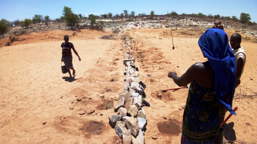
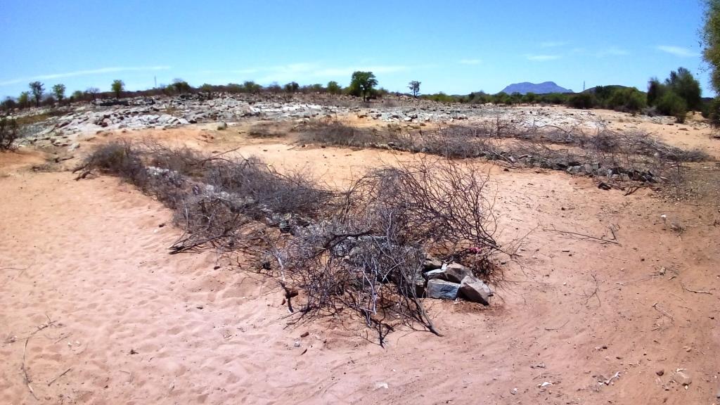
Inappropriate grazing regimes and poor livestock management by pastoral communities in SW Angola have led to degradation of rangeland and pastoral resources, with perennial grassland species and shrubs having been effectively eliminated. This is despite the fact that the pastoral communities of the area know their environment extremely well and are aware of the land degradation happening around them. Under the project they identified crucial areas for rehabilitation works, selecting mostly areas around water points that have been in use both by local and transhumant herders. Through these works, the local community sought to (a) increase ground cover to reduce sediment loads entering waterways (erosion control), (b) provide shade for livestock, (c) increase forage production and (d) introduce legumes and multipurpose forage trees in areas of high animal traffic. A total of four areas in the Bibala and Virei Municipalities were identified for the activities.
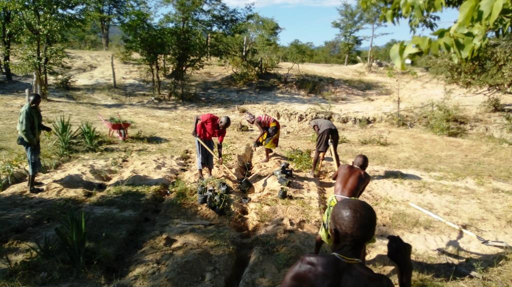
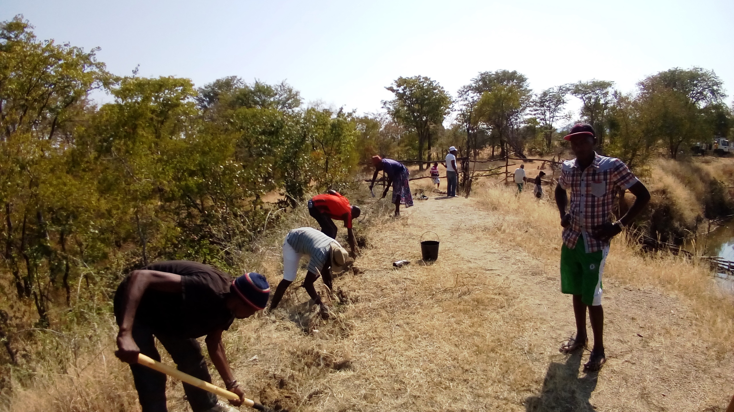
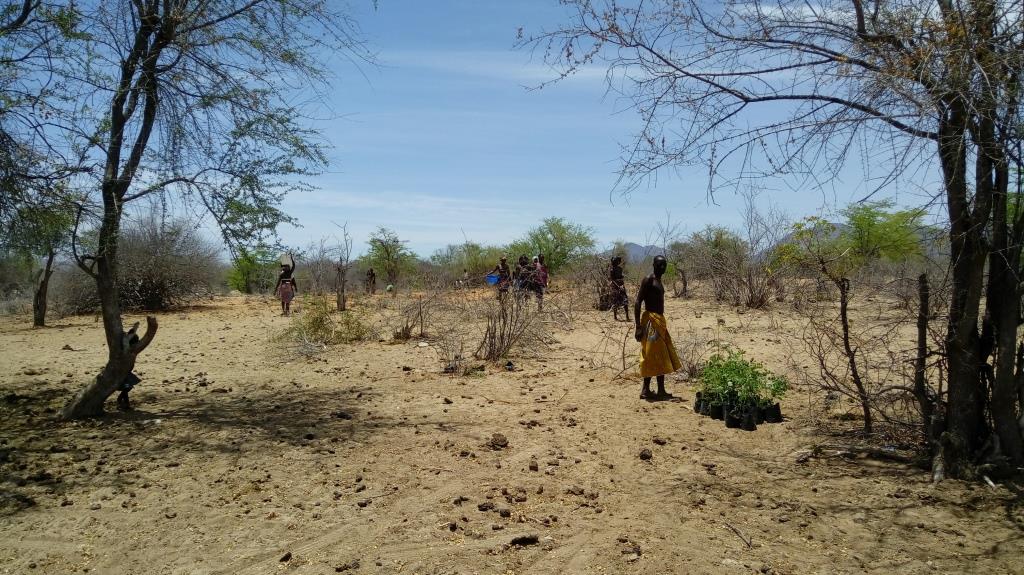
The communities were closely involved in the selection and propagation of plant species for the rehabilitation works. The project field staff also ran field palatability trials with them to confirm that the plants selected met their expectations. These participatory trials were also aimed at enhancing their understanding of livestock nutrition and how it related to animal health. Once the species were chosen, seed was collected by the communities and the Project Technicians, and was multiplied in 32 Agro-Pastoral Field School Nurseries and 2 Government funded Veterinary Research Stations. A total of 15 species were identified, with the grasses Eragrostis superba, Urochloa mosambicensis, and the trees Acacia nilotica, Faidherbia albida, Leucaena leucocephala and Moringa oleifera being the most valued by the communities as forage and multipurpose species. The trees were germinated from seed with success. However, native grass species failed to germinate by standard methods - early field trials having ruled out direct seeding methods. Thus they were multiplied by root division of plants collected from cultivated fields. This avoided removal of grass from natural areas.
As the majority of the areas selected for the rehabilitation works were focused around water points and waterways, the soils were generally alluvial, sandy loams. Precipitation is highest in the areas to the north: it ranges from 600 mm in the upper areas of the Bibala Municipality to 200 mm in the areas to the south in Virei. In general, the vegetation communities could be described as dry sclerophyll woodlands with Colophospermum mopane being the dominant tree species, with forest cover decreasing in height and density as one moves south toward drier areas.
Through close collaboration with the participant communities, three rehabilitation methods were designed and improved upon throughout the Project's duration. Method 1 was used to plant open areas within the rehabilitation zone, Method 2 was employed to introduce and protect concentrated plantings of the selected species in strategic locations within the landscape, and Method 3 was preferred for the recuperation of riparian vegetation and to reduce sediment loads in waterways. The three methods used are described in more detail in the Technical Drawings. To increase the sense of ownership and thus the sustained effectiveness of the rehabilitation works, land management plans and other supporting activities were also carried out.
2.3 Fotografías de la Tecnología
Galería de medios
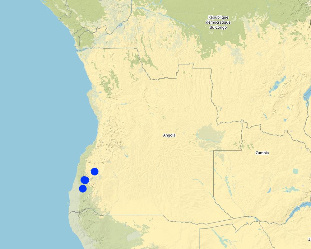
2.5 País/ región/ lugares donde la Tecnología fue aplicada y que se hallan comprendidos por esta evaluación
País:
Angola
Región/ Estado/ Provincia:
Province of Namibe
Especifique más el lugar :
Municipalities of Bibala and Virei
Especifique la difusión de la Tecnología:
- aplicada en puntos específicos/ concentrada en un área pequeña
Comentarios:
There are 3 main rehabilitation areas, all within the Namibe Province in Southern Angola.
Planting areas are selected due to their importance and relevance to the local communities. For the most part, the plantings have been centred around key water points. In order to increase impact and scale up the process of rangeland rehabilitation and improvement, management plans are negotiated and agreed upon by the communities through the Green Negotiated Territorial Development Approach (GreeNTD) processes.
Map
×2.6 Fecha de la implementación
Si no se conoce el año preciso, indique la fecha aproximada:
- hace menos de 10 años (recientemente)
2.7 Introducción de la Tecnología
Especifique cómo se introdujo la Tecnología:
- mediante proyectos/ intervenciones externas
Comentarios (tipo de proyecto, etc.):
The proposed project: “Land rehabilitation and rangelands management in smallholders’ agropastoral production systems in southwestern Angola” (RETESA) is a joint effort by the Ministério do Ambiente (MA), Ministério da Agricultura e do Desenvolvimento Rural e das Pescas (MINANDER), Governo Provincial do Namibe, Governo Provincial do Huila, and Governo Provincial de Benguela, together with FAO and GEF. In line with the GEF-5 Land Degradation strategy, the project’s goal is to create an enhanced enabling environment in the agricultural sector and a sustained flow of agro-ecosystem services.
3. Clasificación de la Tecnología MST
3.1 Propósito(s) principal(es) de la Tecnología MST
- mejorar la producción
- reducir, prevenir, restaurar la degradación del suelo
- conservar el ecosistema
- preservar/ mejorar biodiversidad
- reducir el riesgo de desastres naturales
- adaptarse al cambio climático/ extremos climáticos y sus impactos
- mitigar cambio climático y sus impactos
- crear impacto económico benéfico
3.2 Tipo(s) actuales de uso de la tierra donde se aplica la Tecnología

Tierra de pastoreo
Pastoreo extenso:
- Pastoralismo semi-nómada
- Transhumance movements
Tipo de animal:
- ganado - lechero
- ganado - carne de res no lechera
- cabras
Productos y servicios:
- carne
- leche

vías fluviales, masas de agua, humedales
- Líneas de drenaje, vías fluviales
- Estanques, diques
- Natural springs
Comentarios:
Number of growing seasons per year: 1
Livestock density: Official data is not available and true livestock numbers are unknown.
3.3 ¿Cambió el uso de tierras debido a la implementación de la Tecnología?
¿Cambió el uso de tierras debido a la implementación de la Tecnología?
- Sí (Por favor responda las preguntas de abajo referidas al uso de la tierra antes de implementar la Tecnología)
Comentarios:
Crop land is increasing in the area as population increases and people move towards more sedimentary livelihoods.
3.4 Provisión de agua
Provisión de agua para la tierra donde se aplica la Tecnología:
- de secano
3.5 Grupo MST al que pertenece la Tecnología
- pastoralismo y manejo de tierras de pastoreo
- cobertura de suelo/ vegetal mejorada
3.6 Medidas MST que componen la Tecnología

medidas vegetativas
- V1: Cubierta de árboles y arbustos
- V2: Pastos y plantas herbáceas perennes

medidas de manejo
- M2: Cambio de gestión/ nivel de intensidad
Comentarios:
The management plans created at the community and administrative level identify a number of large areas which are to serve as 'Grazing Reverses' for the dry season. Therefore, the agreements call for all livestock to abandon the area at the onset of the first rains and not return until the Pastoral Management Forum agrees to open the area for grazing. Once open, the range is available to all pastoralists, those that live in the immediate area and those moving through on their transhumance migration.
3.7 Principales tipos de degradación del suelo encarados con la Tecnología

erosión de suelos por agua
- Wt: pérdida de capa arable/ erosión de la superficie
- Wr: erosión de riberas

degradación biológica
- Bc: reducción de la cobertura vegetal del suelo
- Bh: pérdida de hábitats
- Bq: reducción de la cantidad/ biomasa
- Bs: reducción en la calidad y composición/ diversidad de las especies
- Bl: pérdida de la vida del suelo
3.8 Prevención, reducción o restauración de la degradación del suelo
Especifique la meta de la Tecnología con relación a la degradación de la tierra:
- reducir la degradación del suelo
- restaurar/ rehabilitar tierra severamente degradada
4. Especificaciones técnicas, actividades de implementación, insumos y costos
4.1 Dibujo técnico de la Tecnología
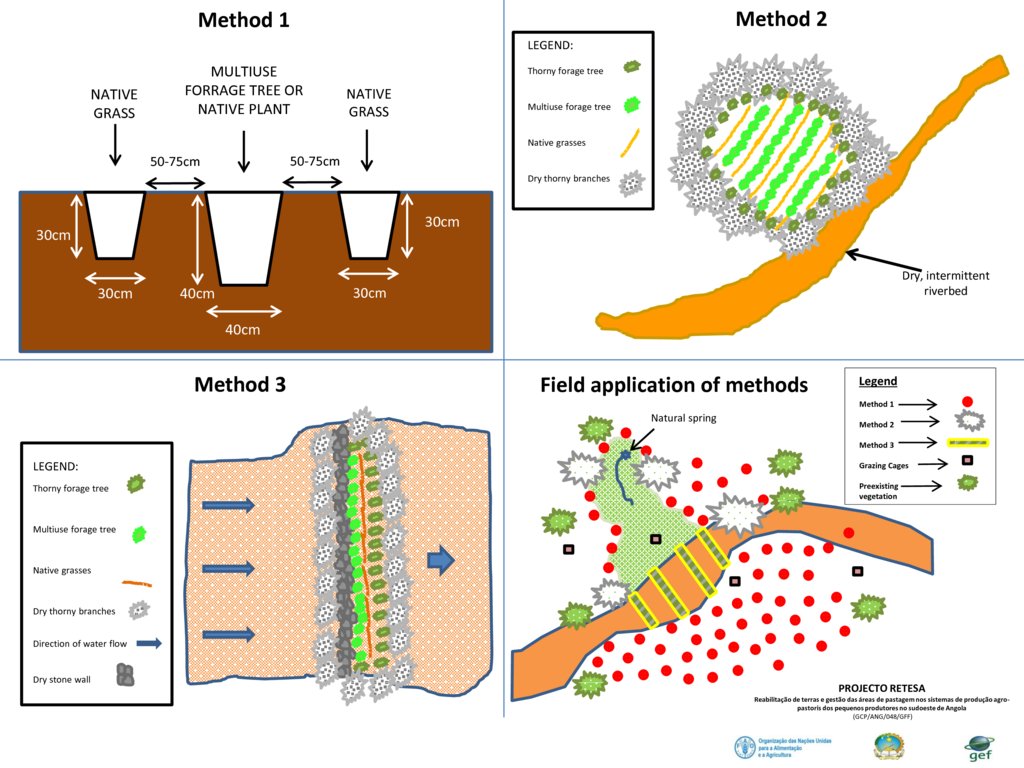
Especificaciones técnicas (relacionadas al dibujo técnico):
Planting is typically based on three different methods, as seen in the figure above.
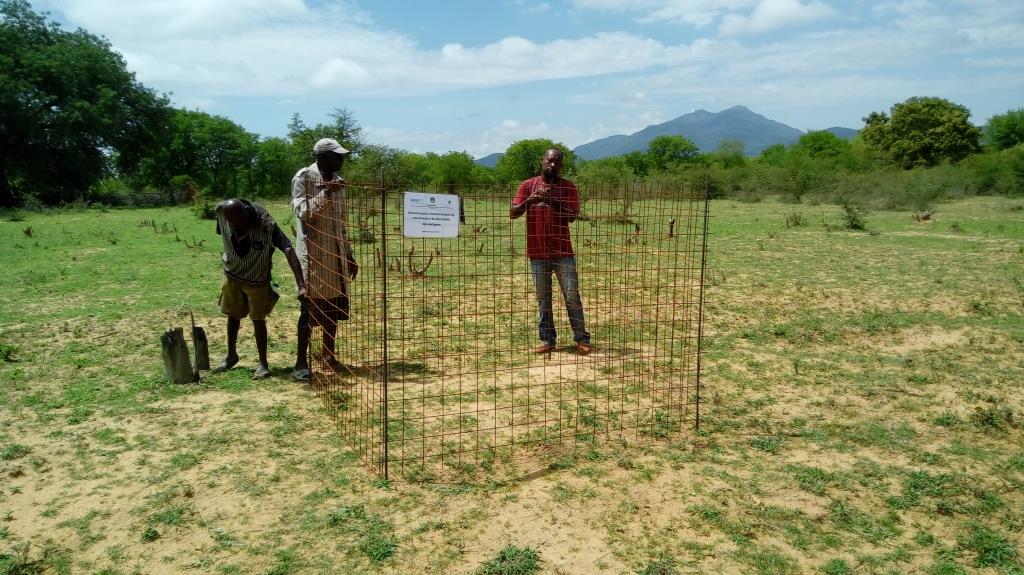
- Method 1 relies on placing a leguminous, multipurpose tree species in the ground with two native grass species to each side of the tree. The holes are dug and a small amount of manure is placed in the bottom of the hole, adding some water if it is readily available. Then the trees and grasses are planted and well-watered. Finally, a branch or two of thorny shrubs or trees are placed over the plants to protect them from being grazed (where possible, dead branches should be used, rather than cutting living plants).
- Method 2 requires the creation of an enclosed, protected area which is then planted at high densities, preferably in low-lying areas where adequate soil moisture is available. Dry, dead branches from thorny trees and shrubs are used to create the enclosures and provide protection to these plantings.
- Method 3 is based on the creation of a 'leaky weir', which is a small stone barrier, horizontal to the flow of water (on the contour) planted with a mixture of native riparian species. This is intended to slow the flow of water and stimulate the recovery of riparian vegetation. The plants are also protected with dry, dead branches from thorny trees and shrubs in this method.
To increase their effectiveness, it is recommended that the three methods be combined within the landscape, as seen in the 4th slide 'Field application of methods'.
Autor:
Projecto RETESA
Fecha:
10/01/2018
4.2 Información general sobre el cálculo de insumos y costos
Especifique cómo se calcularon los costos e insumos:
- por unidad de Tecnología
Especifique unidad:
3345 seedlings produced, delivered and planted
Especifique las dimensiones de la unidad (si fuera relevante):
3345 units
Especifique la moneda usada para calcular costos:
- USD
Indique el costo promedio del salario de trabajo contratado por día:
6 Dollars
4.3 Actividades de establecimiento
| Actividad | Momento (estación) | |
|---|---|---|
| 1. | Meetings and field visits with participant communities to identify plant species and their uses | Best during growing season |
| 2. | Further meetings to decide on which species are to be multiplied and arrange seed collection | Near end of growing season |
| 3. | Seed collection and transportation | When seed is available (varies with species) |
| 4. | Instalation of irrigation systems | Most communiites need a water extraction and distribution system to create nurseries |
| 5. | Delivery of nursery supplies and instalation of shade cloth | Nurseries should have water access and shade |
| 6. | Planting of seeds and care for seedlings at nursery | Formed part of Agro-Pastoral Farmer Field School activities |
| 7. | Identification of planting areas and timing | Should be at beginning of rainy season, or when soil moisture permits |
| 8. | Organisation of materials and tools | At least 1 week before the planting |
| 9. | Planting day (preparation of planting holes and transplanting of seedlings) | 2 days maximum was seen to be optimal |
| 10. | Watering until the plants are established | Usually a maximum of 3 watering over 1 week after the plantings |
| 11. | Follow up visits to make sure management agreements are being respected and plants are not being eaten by stock until they are ready | Plants should not be grazed for at least 6 months from planting time until they are well established |
Comentarios:
The activities and costs given were those needed to produce and plant 3,345 trees and grasses in the 4 rehabilitation areas. Given that 3,345 plants were produced at a cost of $3284.75, the cost per plant produced and planted in the field is $0.98. Seedlings available through local, government nurseries were $2.00 per unit, but only exotic ornamentals were available. However, it can be expected that in other contexts and locations, it would be cheaper to buy seedlings, instead of training communities and creating numerous small-scale nurseries, though clearly these communities will not ‘own’ the process as well as if they were involved from the beginning.
4.4 Costos e insumos necesarios para el establecimiento
| Especifique insumo | Unidad | Cantidad | Costos por unidad | Costos totales por insumo | % de los costos cubiertos por los usuarios de las tierras | |
|---|---|---|---|---|---|---|
| Mano de obra | Project Technicians/Drivers/Consultants, etc | Person-days | 30,0 | 20,0 | 600,0 | |
| Mano de obra | Plant identification activities and seed collection | Person-days | 10,0 | 6,0 | 60,0 | 100,0 |
| Mano de obra | Plant nursery creation and plant production | Person-days | 16,0 | 6,0 | 96,0 | 100,0 |
| Mano de obra | Participation during planting days | Person-days | 25,0 | 10,0 | 250,0 | 90,0 |
| Equipo | Vehicle | Trips | 10,0 | 40,0 | 400,0 | |
| Equipo | Nursery supplies (including water system which also supplies water to Farmer Field School) | Materials | 1,0 | 800,0 | 800,0 | 10,0 |
| Equipo | Planting supplies (shovels, hoes, wheelbarrows, etc.) | Materials | 1,0 | 120,0 | 120,0 | |
| Equipo | Other improvements to water point (fencing, cement blocks, cement, hoses, etc.) | Materials | 1,0 | 250,0 | 250,0 | |
| Equipo | Maps (traced onto paper from projected images for management purposes) | Materials | 1,0 | 10,0 | 10,0 | |
| Equipo | Food and Refreshments | Per person | 25,0 | 2,5 | 62,5 | |
| Fertilizantes y biocidas | Manure (50 grams per sack, 12.500 sacks) | Kilos | 625,0 | 0,25 | 156,25 | 100,0 |
| Material de construcción | Shade-cloth | m2 | 320,0 | 1,5 | 480,0 | |
| Costos totales para establecer la Tecnología | 3284,75 | |||||
| Costos totales para establecer la Tecnología en USD | 3284,75 | |||||
Si el usuario de la tierra no cubrió el 100% de los costos, indique quién financió el resto del costo:
Remaining costs were provided by the RETESA Project.
Comentarios:
Production depends on the ability of the pastoral communities to produce viable plants. If they are unable to do so, then plants can be bought from Government funded nurseries, though costs per plant will most rise though it can substitute the need for having to purchase a water supply system. The total shown here reflects a percentage (16%) of the costs of installing a water system that supplied water to the whole of the Agro-Pastoral Farmer Field School. These systems usually included a 10,000 litre water tank, a gasoline water pump, extraction pipe and parts, 100 to 200 mts of 1.5" hoses and parts and 3 kms of drip irrigation hose.
4.5 Actividades de establecimiento/ recurrentes
| Actividad | Momento/ frequencia | |
|---|---|---|
| 1. | Meetings to ensure management agreements are being respected. | Once every 3 to 6 months, especially before and after rainy season. |
| 2. | Repairs and replacement of nursery supplies. | Once a year. |
| 3. | Replanting of dead seedlings | Just before and during rainy season. |
4.6 Costos e insumos necesarios para actividades de mantenimiento/ recurrentes (por año)
| Especifique insumo | Unidad | Cantidad | Costos por unidad | Costos totales por insumo | % de los costos cubiertos por los usuarios de las tierras | |
|---|---|---|---|---|---|---|
| Mano de obra | Visits to sites and tour of planting areas. | Person-days | 4,0 | 20,0 | 80,0 | 50,0 |
| Mano de obra | Driver. | Person-days | 1,0 | 20,0 | 20,0 | |
| Mano de obra | Replanting of dead seedlings | Person-days | 2,0 | 6,0 | 12,0 | 100,0 |
| Mano de obra | Watering | Person-days | 14,0 | 6,0 | 84,0 | 100,0 |
| Equipo | Vehicle | Trips | 1,0 | 40,0 | 40,0 | |
| Equipo | Watering cans and buckets | Materials | 4,0 | 5,0 | 20,0 | |
| Indique los costos totales para mantenecer la Tecnología | 256,0 | |||||
| Costos totales para mantener la Tecnología en USD | 256,0 | |||||
Si el usuario de la tierra no cubrió el 100% de los costos, indique quién financió el resto del costo:
The RETESA Project provided an important part of both material and technical support to the communities, though the communities also contributed substantially.
4.7 Factores más determinantes que afectan los costos:
Describa los factores más determinantes que afectan los costos:
The activities and costs given were those needed to produce and plant 3,345 trees and grasses in the 4 rehabilitation areas. Given that 3.345 plants were produced at a cost of $3284.75, the cost per plant produced and planted in the field is $0.98. Seedlings avaliable through local, government nurseries were $2.00 per unit, but only exotic ornamentals were avaliable. However, it can be expected that in other contexts and locations, it would be cheaper to buy seedlings instead of training communities and creating numerous small scale nurseries, though clearly these communities will not appropriate the process as well as if they were involved from the beginning.
5. Entorno natural y humano
5.1 Clima
Lluvia anual
- < 250 mm
- 251-500 mm
- 501-750 mm
- 751-1,000 mm
- 1,001-1,500 mm
- 1,501-2,000 mm
- 2,001-3,000 mm
- 3,001-4,000 mm
- > 4,000 mm
Especificaciones/ comentarios sobre la cantidad de lluvia:
In the past, the rainy season started in October or November and ran until May. However, the rains in the last few years have fallen in January to April.
Indique el nombre de la estación metereológica de referencia considerada:
None in the area.
Zona agroclimática
- semi-árida
5.2 Topografía
Pendientes en promedio:
- plana (0-2 %)
- ligera (3-5%)
- moderada (6-10%)
- ondulada (11-15%)
- accidentada (16-30%)
- empinada (31-60%)
- muy empinada (>60%)
Formaciones telúricas:
- meseta/ planicies
- cordilleras
- laderas montañosas
- laderas de cerro
- pies de monte
- fondo del valle
Zona altitudinal:
- 0-100 m s.n.m.
- 101-500 m s.n.m.
- 501-1,000 m s.n.m
- 1,001-1,500 m s.n.m
- 1,501-2,000 m s.n.m
- 2,001-2,500 m s.n.m
- 2,501-3,000 m s.n.m
- 3,001-4,000 m s.n.m
- > 4,000 m s.n.m
Indique si la Tecnología se aplica específicamente en:
- no relevante
Comentarios y especificaciones adicionales sobre topografía :
Usually the planting are undertaken along river plains and river banks, as they are the only areas that have the necessary soil moisture to ensure survival of the seedlings.
5.3 Suelos
Profundidad promedio del suelo:
- muy superficial (0-20 cm)
- superficial (21-50 cm)
- moderadamente profunda (51-80 cm)
- profunda (81-120 cm)
- muy profunda (>120 cm)
Textura del suelo (capa arable):
- áspera/ ligera (arenosa)
Textura del suelo (> 20 cm debajo de la superficie):
- áspera/ ligera (arenosa)
Materia orgánica de capa arable:
- baja (<1%)
5.4 Disponibilidad y calidad de agua
Agua subterránea:
< 5 m
Disponibilidad de aguas superficiales:
pobre/ ninguna
Calidad de agua (sin tratar):
agua potable de mala calidad (requiere tratamiento)
¿La salinidad del agua es un problema?
Sí
Especifique:
Many bores and wells cannot be used due to Salinity problems. Before planting, it is wise to make sure soil salinity is not problematic in areas identified.
¿Se está llevando a cabo la inundación del área? :
Sí
Frecuencia:
frecuentemente
Comentarios y especificaciones adicionales sobre calidad y cantidad de agua:
Water quality and quantity are major issues for the area. There are few if any reliable water sources in the area and most communities depend on wells dug in the river bottoms to supply their water.
5.5 Biodiversidad
Diversidad de especies:
- mediana
Diversidad de hábitats:
- baja
Comentarios y especificaciones adicionales sobre biodiversidad:
The area is devoid of most wild animals due to the years of war the country experienced during the second half of the 20th century.
5.6 Las características de los usuarios de la tierra que aplican la Tecnología
Sedentario o nómada:
- Semi-nómada
Orientación del mercado del sistema de producción:
- subsistencia (autoprovisionamiento)
Ingresos no agrarios:
- 10-50% de todo el ingreso
Nivel relativo de riqueza:
- muy pobre
Individuos o grupos:
- individual/ doméstico
Nivel de mecanización:
- trabajo manual
Género:
- mujeres
- hombres
Edad de los usuarios de la tierra:
- jóvenes
- personas de mediana edad
Indique otras características relevantes de los usuarios de las tierras:
The communities are still traditional though are currently being influenced by the globalisation process.
5.7 Área promedio de la tierra usada por usuarios de tierra que aplican la Tecnología
- < 0.5 ha
- 0.5-1 ha
- 1-2 ha
- 2-5 ha
- 5-15 ha
- 15-50 ha
- 50-100 ha
- 100-500 ha
- 500-1,000 ha
- 1,000-10,000 ha
- > 10,000 ha
¿Esto se considera de pequeña, mediana o gran escala (refiriéndose al contexto local)?
- gran escala
Comentarios:
Agricultural plots are considered private and are usually between 1 to 2 hectares, though grazing land, which makes up the majority of the area, is still commonly owned and covers vast areas.
5.8 Tenencia de tierra, uso de tierra y derechos de uso de agua
Tenencia de tierra:
- comunitaria/ aldea
Derechos de uso de tierra:
- acceso abierto (no organizado)
Derechos de uso de agua:
- acceso abierto (no organizado)
5.9 Acceso a servicios e infraestructura
salud:
- pobre
- moderado
- bueno
educación:
- pobre
- moderado
- bueno
asistencia técnica:
- pobre
- moderado
- bueno
empleo (ej. fuera de la granja):
- pobre
- moderado
- bueno
mercados:
- pobre
- moderado
- bueno
energía:
- pobre
- moderado
- bueno
caminos y transporte:
- pobre
- moderado
- bueno
agua potable y saneamiento:
- pobre
- moderado
- bueno
servicios financieros:
- pobre
- moderado
- bueno
6. Impactos y comentarios para concluir
6.1 Impactos in situ demostrados por la Tecnología
Impactos socioeconómicos
Producción
producción de forraje
Cantidad antes de MST:
Low rangeland production
Cantidad luego de MST:
Slight improvement
Comentarios/ especifique:
Difficult to measure. Rehabilitation works and the management plans for the rangeland areas have led to some improvement, though the droughts affecting the area during the interventions significantly affected rangeland fodder production.
calidad de forraje
Cantidad antes de MST:
No crop residues or fodder plantings used
Cantidad luego de MST:
Crop residues and fodder plantings incorporated in cropping areas
Comentarios/ especifique:
The process allowed Project Technicians to educate communities on the use of crop residues as fodder and the planting of multiuse trees within cropping areas to provide green fodder in the dry season. The reintroduction of drought tolerant, quality indigenous grasses should also lead an increase in fodder production over the coming year.
producción animal
Cantidad antes de MST:
No planning for dry season grazing, apart from transhumance movements
Cantidad luego de MST:
Crop residues and other cultivated forages produced for those animals that stay
Comentarios/ especifique:
The transhumance movements of livestock are still seen as the most adequate solution to changes in natural rangeland production, though most families leave behind some animals with the main family unit. These animals are now receiving the quality feed they need to remain productive and healthy.
manejo de tierras
Cantidad antes de MST:
No management plans in place for commonly managed natural resources
Cantidad luego de MST:
Participatory land management plans have been negociated and agreed
Comentarios/ especifique:
Simplified land management plans based on traditional livestock movements and cropping seasons have been negotiated and agreed by local stakeholders and municipal Administrators.
Disponibilidad y calidad de agua
calidad de agua potable
Cantidad antes de MST:
Livestock and communities drink from same water
Cantidad luego de MST:
Separate water drinking points for livestock and community
Comentarios/ especifique:
Unrestricted access of livestock to community domestic water points led to waterborne diseases and poor water quality. Separating livestock and domestic use has improved community health.
disponibilidad de agua para ganado
Comentarios/ especifique:
In addition to restricting livestock access to main water bodies, new drinking troughs have been built with community support.
calidad de agua para ganado
Comentarios/ especifique:
By separating livestock drinking points and domestic water points, waterborne illnesses have been reduced. In at least one area a water tank and new drinking trough have been built with community support.
Impactos socioculturales
MST/ conocimiento de la degradación del suelo
Cantidad antes de MST:
No education or training on land degradation
Cantidad luego de MST:
Education and training on land degradation issues and rehabilitation methods
Comentarios/ especifique:
The majority of communities that have gone through the process now understand how poor land management leads to land degradation and steps they can take to reduce it.
Impactos ecológicos
Ciclo de agua/ escurrimiento de sedimento
cantidad de agua
Comentarios/ especifique:
Improved ground cover and the return of riparian vegetation would increase infiltration rates and decrease evapotranspiration rates and restore the micro water cycle. But this is also a long term process.
calidad de agua
Cantidad antes de MST:
Low
Cantidad luego de MST:
Low in short term, improved in long term
Comentarios/ especifique:
Revegetation of river plains and river banks should lead to improved water quality though it will be a long term effect if the rehabilitation areas are respected.
escurrimiento superficial
Cantidad antes de MST:
No method to deal with the high surface runoff rates in the area
Cantidad luego de MST:
A method has been devised for reducing surface runoff rates.
Comentarios/ especifique:
The 'leaky weir' method (Rehabilitation method 3) has shown promise over the duration of the Project and could be applied at other landscape levels to reduce surface runoff.
Suelo
cubierta del suelo
Comentarios/ especifique:
The reintroduction of native grasses in the area should lead to improved ground cover, binding the soil and reducing erosion rates.
pérdida de suelo
Comentarios/ especifique:
The reintroduction of native grasses in the area should lead to improved ground cover ratios, binding the soil and reducing erosion rates.
ciclo/ recarga de nutrientes
Comentarios/ especifique:
Proper livestock management also ensures that manure is properly and evenly distributed in the field.
Biodiversidad: vegetación, animales
Cubierta vegetal
Cantidad antes de MST:
Reduced number of poor quality grass species
Cantidad luego de MST:
Communities capacitated in plant multiplication methods
Comentarios/ especifique:
Apart from the rehabilitation works themselves, the local communities have been capacitated with methods to approach and deal with land degradation.
biomasa/ sobre suelo C
diversidad vegetal
Comentarios/ especifique:
The reintroduction of native and leguminous plants has improved plant diversity both within rehabilitation areas and cultivated lands.
Reducción de riesgos de desastres y riesgos climáticos
impactos de sequías
micro-clima
Comentarios/ especifique:
The works around the water points over time should lead to increase in vegetative cover, shade, habitat and reduced temperatures.
6.2 Impactos fuera del sitio demostrados por la Tecnología
capacidad de amortiguación/ filtrado
6.3 Exposición y sensibilidad de la Tecnología al cambio climático gradual y a extremos relacionados al clima/ desastres (desde la percepción de los usuarios de tierras)
Cambio climático gradual
Cambio climático gradual
| Estación | Incremento o reducción | ¿Cómo es que la tecnología soporta esto? | |
|---|---|---|---|
| lluvia anual | disminuyó | bien | |
| lluvia estacional | primavera | disminuyó | bien |
6.4 Análisis costo-beneficio
¿Cómo se comparan los beneficios con los costos de establecimiento (desde la perspectiva de los usuarios de tierra)?
Ingresos a corto plazo:
neutral/ balanceado
Ingresos a largo plazo:
positivo
¿Cómo se comparan los beneficios con los costos de mantenimiento/ recurrentes (desde la perspectiva de los usuarios de tierra)?
Ingresos a corto plazo:
neutral/ balanceado
Ingresos a largo plazo:
positivo
6.5 Adopción de la Tecnología
- casos individuales / experimentales
De todos quienes adoptaron la Tecnología, ¿cuántos lo hicieron espontáneamente, por ej. sin recibir nada de incentivos/ materiales:
- 0-10%
6.6 Adaptación
¿La tecnología fue modificada recientemente para adaptarse a las condiciones cambiantes?
No
6.7 Fuerzas/ ventajas/ oportunidades de la Tecnología
| Fuerzas/ ventajas/ oportunidades desde la perspectiva del usuario de la tierra |
|---|
| Communities learn about plants' role in the wider ecosystem, how to select and multiply key fruit, fodder or timber species and should see an increase in their horticultural and livestock production, leading to improved nutrition or income. |
| Done properly, it can be a cost-effective and reliable way to produce the plants needed within family units. |
| Fuerzas/ ventajas/ oportunidades desde la perspectiva del compilador o de otra persona de referencia clave |
|---|
| When the plants are produced in collaboration with the local pastoral communities, the benefits are wide ranging, promoting everything from environmental awareness to technical and practical knowledge. |
| It remains a cost-effective way of improving key productive species and increasing community resilience. |
| Increasing biomass and introducing better management cycles contribute to reducing land degradation and improve nutrient and energy cycling. |
6.8 Debilidades/ desventajas/ riesgos de la Tecnología y formas de sobreponerse a ellos
| Debilidades/ desventajas/ riesgos desde la perspectiva del usuario de la tierra | ¿Cómo sobreponerse a ellas? |
|---|---|
| Can require stable supply of water, and labour costs can increase if water sources are not easily accessible. | Locate nurseries near reliable and accessible water sources. |
| Can require permanent residence, so as to be able to care for plants until they are developed and placed in the ground at the proper date in the calendar (before or during rainy season). | Not easy in nomadic cultures. |
| Early attempts often fail to produce lasting results. | Concentrate early efforts on small experimental plots so as to fine-tune planting methods and timing. |
| Debilidades/ desventajas/ riesgos desde la perspectiva del compilador o de otra persona de referencia clave | ¿Cómo sobreponerse a ellas? |
|---|---|
| The technology is usually not suitable for large areas of land (>1,000 hectares). | Compliment any rehabilitation efforts with improved management plans which are developed with stakeholder input and approval. |
| Plant losses are typically high, especially if rains fail to arrive, or if the year is abnormally dry. | Watch weather forecast to try and focus planting campaigns on those days with a high probability of rain. |
| Local species are often not valued by local officials and technicians, leading to a predominance of exotic species in rehabilitation works. | Undertake awareness and training sessions which highlight the value and uses of native species with local land users and administrative officials. |
7. Referencias y vínculos
7.1 Métodos/ fuentes de información
- visitas de campo, encuestas de campo
The Project has a number of activities in the communities where the technology was used so there were numerous visits and interviews.
- entrevistas con usuarios de tierras
Various information and survey methods were used throughout the RETESA Project, providing a solid basis from which to involve landusers and SLM specialists in decisionmaking processes.
- entrevistas con especialistas/ expertos en MST
3 SLM specialists.
¿Cuándo se compilaron los datos (en el campo)?
15/05/2017
7.3 Vínculos a la información relevante disponible en línea
Título/ descripción:
FAO in Action: Using indigenous knowledge to reverse land degradation in Angola.
URL:
http://www.fao.org/in-action/using-indigenous-knowledge-to-reverse-land-degradation-in-angola/en/
Vínculos y módulos
Expandir todo Colapsar todosVínculos
No hay vínculos
Módulos
No se hallaron módulos