Ecosystem-wide seasonal grazing management in community land [Kenia]
- Creación:
- Actualización:
- Compilador: Peter Tyrrell
- Editores: Enoch Mobisa, Lance W. Robinson
- Revisores: Donia Mühlematter, Hanspeter Liniger, Rima Mekdaschi Studer, Alexandra Gavilano
technologies_3372 - Kenia
Visualizar secciones
Expandir todo Colapsar todos1. Información general
1.2 Detalles de contacto de las personas de referencia e instituciones involucradas en la evaluación y la documentación de la Tecnología
Nombre del proyecto que financió la documentación/ evaluación de la Tecnología (si fuera relevante)
Book project: Guidelines to Rangeland Management in Sub-Saharan Africa (Rangeland Management)1.3 Condiciones referidas al uso de datos documentados mediante WOCAT
El compilador y la/s persona(s) de referencia claves aceptan las condiciones acerca del uso de los datos documentados mediante WOCAT:
Sí
1.4 Declaración de la sostenibilidad de la Tecnología descrita
¿La Tecnología aquí descrita resulta problemática en relación a la degradación de la tierra, de tal forma que no puede considerársela una tecnología sostenible para el manejo de la tierra?
No
1.5 Referencia al (los) Cuestionario(s) de Enfoques MST (documentados usando WOCAT)
Community-based rangeland management in the southern Kenyan rangelands [Kenia]
Olkiramatian Group Ranch strengthened the capacity of its community governance structures and began to engage in more rigorous implementation of seasonal grazing plans. This was based on traditional ecological knowledge and rangeland management practices. The group ranch incorporated conservation, research, and joint rangeland management planning with neighboring communities.
- Compilador: Lance W. Robinson
2. Descripción de la Tecnología MST
2.1 Breve descripción de la Tecnología
Definición de la Tecnología:
Livestock movements are managed through community governance systems to maintain spatial and temporal heterogeneity of pasture, creating a gradient of quality and quantity of pasture across the landscape. This is achieved through clearly designated seasonal grazing areas for livestock and tight controls on settlement areas, grazing patterns and water points. In addition, at the individual herder level, traditional ecological knowledge plays a strong role in the decisions made to improve livestock production
2.2 Descripción detallada de la Tecnología
Descripción:
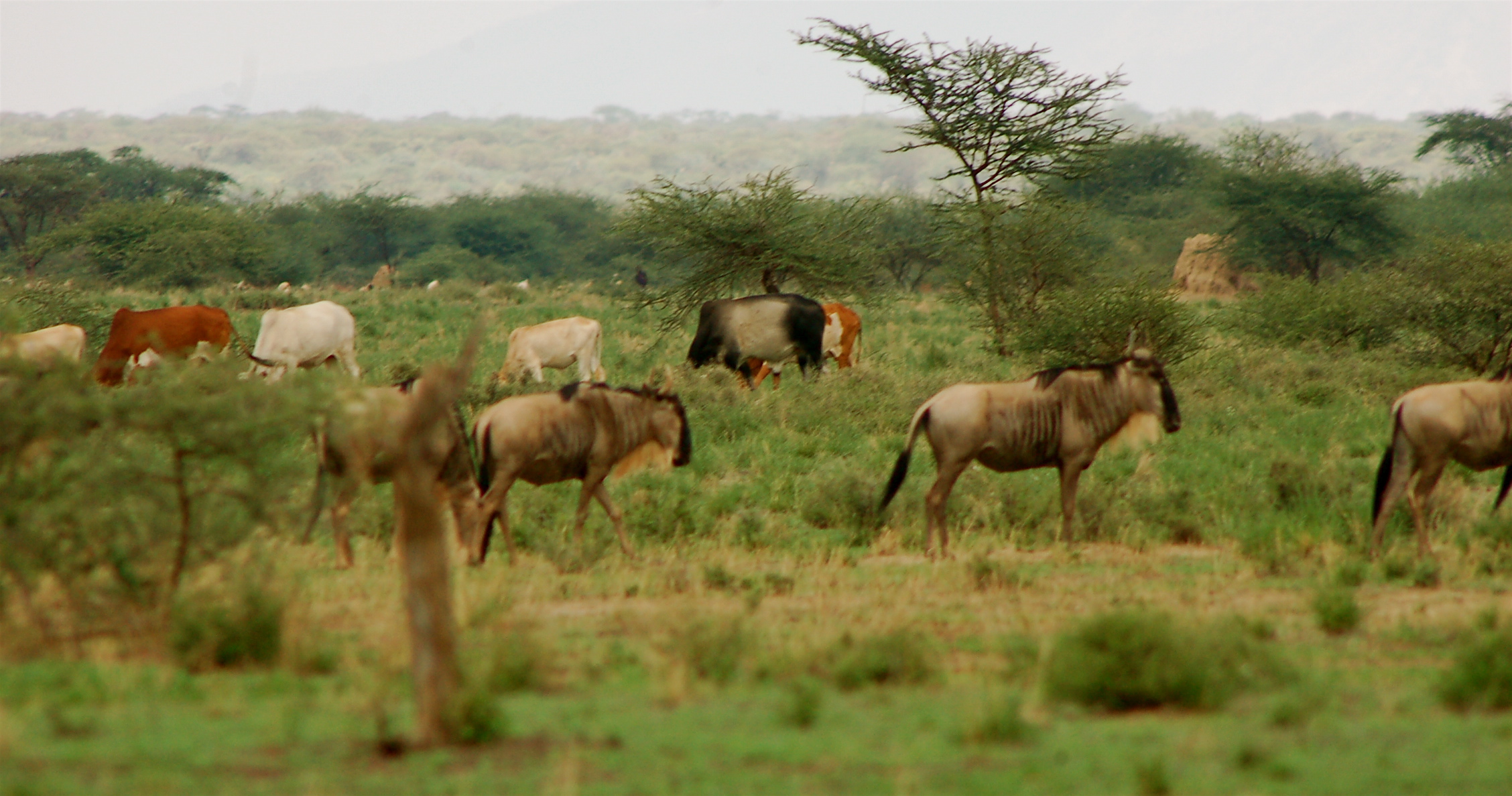
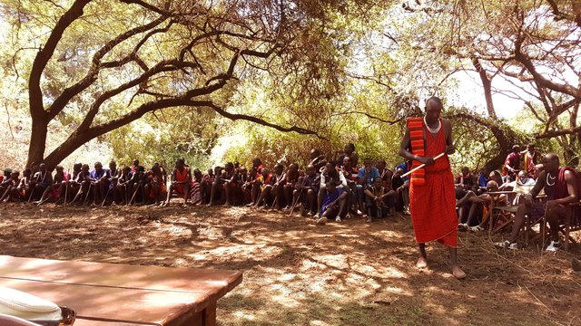
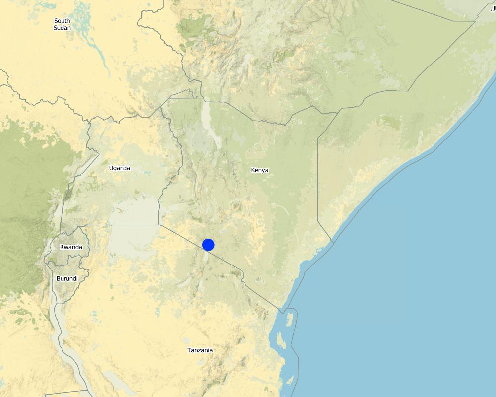
This technology is applied in the South Rift Valley, Kenya, across a semi-arid landscape, with erratic rainfall averaging 400-600 mm per annum. Water availability is an issue. The perennial Ewaso Ngiro South river flows through the Shompole swamp, a vital drought refuge for livestock and wildlife, before ending up in Lake Natron. The area, roughly 1000 km2, is covered by two group ranches, Olkiramatian and Shompole, which are managed as a single ecological unit. A group ranch is a jointly owned freehold land title given to the customary occupants of communal lands. The total number of occupants of both ranches number roughly 20,000 people, with the majority belonging to the Maasai ethnic group. The ranches have not been subdivided and are not fully sedentary, unlike many other areas of southern Kenya.
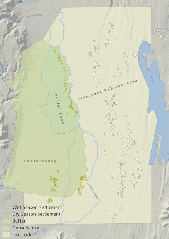
There is a long history of co-existence of wildlife and livestock in Maasialand. In Olkiramatian and Shompole seasonal livestock movements and herding practices are formalized by group ranch grazing plans governed by local committees. The wet season grazing areas are termed “livestock rearing zones”. The dry season grazing areas have been retained as “grass banks” for livestock, and since the early 2000s, have been used additionally as wildlife conservancies for ecotourism (see figure below). Livestock rearing occurs to the east of the Ewaso Ngiro river; grass banks and the wildlife conservancy to the west. Grazing committees from both group ranches manage livestock access to certain areas, with the conservancy (grass bank) rested during the wet season of up to six months. When grazing is permitted in the conservancy, as the dry season progresses, temporary settlements are limited to an area called the “buffer zone”. Livestock must then move into the conservancy from the buffer zones to access this late season grazing. The “livestock rearing zone” is permanently settled and grazed year-round. Within each zone there are small “Olopololis” (grass banks of a few hectares), situated near individual settlements and used to maintain higher quality pasture for weak and young animals. This management strategy ensures that the dry season grazing area is rested during the rains, and it helps to maintain consistently higher biomass and taller grass than that of the wet season grazing area. The higher biomass also corresponds to a rainfall gradient running from the Nguruman Escarpment edge in the western extremity of the group ranches to the dry central rift valley floor in the east. The biomass in the dry season area is used by both livestock and wildlife grazers during the late dry season and in droughts. The grass bank is only grazed out during prolonged dry periods. The Maasai employ a strategy of using the shorter milk-producing grasses of the livestock areas during the rains and the coarser grasses in the grass banks for the dry seasons. The shorter wet season pastures have a higher nutrient content and greater digestibility than the grass bank: this is very important for lactating females. The grass is kept short from both grazing by livestock during the growing seasons and due to intrinsic differences caused by shallower soils and lower rainfall in these grazing areas.
Within this broader governance framework and control of grazing areas, individual decision making is also permitted within these controlled areas. This allows herders to manage livestock to improve production in relation to each herd. For example, individuals might split the herd to take advantage of different energy and nutrient requirements of lactating females, bulls, and calves.
This maintenance and exploitation of forage heterogeneity is vital to the productivity and resilience of the landscape, and this heterogeneity exists at multiple scales, with the major differences existing between the grazing areas, but also smaller difference within them. Resource heterogeneity facilitates wildlife-livestock coexistence. This heterogeneity creates a matrix of varying quality and quantity of forage. Wildlife species have different metabolic requirements and diets, and this varied base ensures that a diverse wild ungulate population is maintained year-round. Late season forage boosts the resilience of wildlife during extreme events. This technology requires a governance structure that is both responsive to the changing ecological conditions and able to build consensus and enforce grazing management.
2.3 Fotografías de la Tecnología
Galería de medios
2.5 País/ región/ lugares donde la Tecnología fue aplicada y que se hallan comprendidos por esta evaluación
País:
Kenia
Región/ Estado/ Provincia:
Kajiado
Especifique más el lugar :
Olkiramatian
Especifique la difusión de la Tecnología:
- distribuida parejamente sobre un área
Si se desconoce el área precisa, indique el área aproximada cubierta:
- 100-1,000 km2
Comentarios:
The technology formerly worked across the entirety of Maasailand (50,000 km2). However, breakdowns in social structures, culture, and governance arrangements have led to wide-scale losses in traditional grazing management. Olkiramtian and its neighbor Shompole, are two of the few communities managing to graze in such a way to maintain and capitalize on the spatial-temporal heterogeneity of forage resources through merging traditional and modern institutions.
Map
×2.6 Fecha de la implementación
Indique año de implementación:
2004
2.7 Introducción de la Tecnología
Especifique cómo se introdujo la Tecnología:
- como parte de un sistema tradicional (> 50 años)
Comentarios (tipo de proyecto, etc.):
The grazing management system is adapted from traditional grazing management of Maasai pastoralists.
3. Clasificación de la Tecnología MST
3.1 Propósito(s) principal(es) de la Tecnología MST
- mejorar la producción
- reducir, prevenir, restaurar la degradación del suelo
- conservar el ecosistema
- preservar/ mejorar biodiversidad
- mitigar cambio climático y sus impactos
- crear impacto económico benéfico
3.2 Tipo(s) actuales de uso de la tierra donde se aplica la Tecnología

Tierra de pastoreo
Pastoreo extenso:
- Pastoralismo semi-nómada
Tipo de animal:
- cabras
- ovejas
- cattle
Comentarios:
Number of growing seasons per year: 2
Long rains fall between April - June; Short rains fall between October - December.
Livestock density: Cattle 6.2 / km2; Shoats 52.2 / km2
3.4 Provisión de agua
Provisión de agua para la tierra donde se aplica la Tecnología:
- de secano
Comentarios:
The area is semi-arid and receives rainfall erratically, both in space and time, in a bi-modal pattern.
3.5 Grupo MST al que pertenece la Tecnología
- pastoralismo y manejo de tierras de pastoreo
3.6 Medidas MST que componen la Tecnología

medidas de manejo
- M2: Cambio de gestión/ nivel de intensidad
- M3: disposición de acuerdo al entorno natural y humano
- M4: Cambios significativos en la programación de las actividades
3.7 Principales tipos de degradación del suelo encarados con la Tecnología

erosión de suelos por agua
- Wt: pérdida de capa arable/ erosión de la superficie

degradación biológica
- Bc: reducción de la cobertura vegetal del suelo
- Bh: pérdida de hábitats
- Bq: reducción de la cantidad/ biomasa
- Bs: reducción en la calidad y composición/ diversidad de las especies
3.8 Prevención, reducción o restauración de la degradación del suelo
Especifique la meta de la Tecnología con relación a la degradación de la tierra:
- prevenir la degradación del suelo
Comentarios:
Although in general, this technology aims to prevent land degradation through the maintenance of forage cover; localized degradation does occur across different locations within the landscape, especially in areas of highest livestock impact, such as water points and settlement areas.
4. Especificaciones técnicas, actividades de implementación, insumos y costos
4.1 Dibujo técnico de la Tecnología
Especificaciones técnicas (relacionadas al dibujo técnico):
The drawing shows the management units used in this seasonally structured grazing management system. The livestock rearing zone, to the east of the Ewaso Nyiro river, is permanently settled and is grazed heavily during the wet season (April - July). During this time herders utilize the short, nutritious grasses in this low biomass area. As forage biomass begins to reduce the community grazing committees meet to discuss the opening of settlements to the west of the Ewaso Nyiro river. This decision is made using traditional ecological knowledge, comparing available forage biomass and the numbers of livestock to previous years and past experiences. Once the grazing has been opened to the west of the river people may settle within the buffer zone. This limits direct access to the higher biomass areas within the conservancy and grass banks, and increases the length of travel for each herd every day, in an effort to preserve forage for longer. Once forage has been depleted in the buffer zones and the periphery of the conservancies, the committees meet and allow access for herders into the conservation areas, which have tall, high biomass, but low-quality grazing. Often access to this area requires considerable distances to be walked by livestock. In recent years, adaptive management systems have led to the settlements within the south of the conservation area to be closed to preserve forage biomass within the swamp and conservation area for a longer period of time; and allow for recovery of partially degraded land.
Autor:
Peter Tyrrell
Fecha:
01/02/2018
4.2 Información general sobre el cálculo de insumos y costos
Especifique cómo se calcularon los costos e insumos:
- por unidad de Tecnología
Especifique unidad:
The two group ranches
Especifique las dimensiones de la unidad (si fuera relevante):
Approximately 1000km2
Especifique la moneda usada para calcular costos:
- USD
Indique el costo promedio del salario de trabajo contratado por día:
4
4.3 Actividades de establecimiento
Comentarios:
No activities were required to establish this practice as it has been ongoing and builds on traditional management structures.
4.4 Costos e insumos necesarios para el establecimiento
Comentarios:
N/A
4.5 Actividades de establecimiento/ recurrentes
| Actividad | Momento/ frequencia | |
|---|---|---|
| 1. | Management meetings | Seasonally |
4.6 Costos e insumos necesarios para actividades de mantenimiento/ recurrentes (por año)
Comentarios:
The only real costs of this technology, which is different to any other form of grazing system, would be the cost of management through meetings. Otherwise the costs are just that of any other livestock production enterprise.
4.7 Factores más determinantes que afectan los costos:
Describa los factores más determinantes que afectan los costos:
There are no or little costs to this technology, as it builds off structures of management which are already in place and work organically within the area.
5. Entorno natural y humano
5.1 Clima
Lluvia anual
- < 250 mm
- 251-500 mm
- 501-750 mm
- 751-1,000 mm
- 1,001-1,500 mm
- 1,501-2,000 mm
- 2,001-3,000 mm
- 3,001-4,000 mm
- > 4,000 mm
Especifique el promedio anual de lluvia (si lo conoce), en mm:
400,00
Especificaciones/ comentarios sobre la cantidad de lluvia:
Highly variable rainfall both spatially and temporally. Annual average rainfall has a 33%CV.
Indique el nombre de la estación metereológica de referencia considerada:
Lale'enok Resource Centre
Zona agroclimática
- semi-árida
- árida
5.2 Topografía
Pendientes en promedio:
- plana (0-2 %)
- ligera (3-5%)
- moderada (6-10%)
- ondulada (11-15%)
- accidentada (16-30%)
- empinada (31-60%)
- muy empinada (>60%)
Formaciones telúricas:
- meseta/ planicies
- cordilleras
- laderas montañosas
- laderas de cerro
- pies de monte
- fondo del valle
Zona altitudinal:
- 0-100 m s.n.m.
- 101-500 m s.n.m.
- 501-1,000 m s.n.m
- 1,001-1,500 m s.n.m
- 1,501-2,000 m s.n.m
- 2,001-2,500 m s.n.m
- 2,501-3,000 m s.n.m
- 3,001-4,000 m s.n.m
- > 4,000 m s.n.m
Indique si la Tecnología se aplica específicamente en:
- no relevante
Comentarios y especificaciones adicionales sobre topografía :
This area lies at the bottom of the rift valley, with the Nguruman Escarpment and Loita Hills towering up to the west. This change in elevation ensures that there is fresh water reaching the area year round and that there is very late season forage available at higher altitudes if required.
5.3 Suelos
Profundidad promedio del suelo:
- muy superficial (0-20 cm)
- superficial (21-50 cm)
- moderadamente profunda (51-80 cm)
- profunda (81-120 cm)
- muy profunda (>120 cm)
Textura del suelo (capa arable):
- áspera/ ligera (arenosa)
- mediana (limosa)
Textura del suelo (> 20 cm debajo de la superficie):
- áspera/ ligera (arenosa)
- mediana (limosa)
5.4 Disponibilidad y calidad de agua
Agua subterránea:
> 50 m
Disponibilidad de aguas superficiales:
pobre/ ninguna
Calidad de agua (sin tratar):
agua potable de mala calidad (requiere tratamiento)
¿La salinidad del agua es un problema?
No
¿Se está llevando a cabo la inundación del área? :
Sí
Frecuencia:
frecuentemente
Comentarios y especificaciones adicionales sobre calidad y cantidad de agua:
Seasonal floods down the Ewaso Nyiro river provide an important water source for the Shompole Swamp. This swamp acts as an import drought refuge for livestock.
5.5 Biodiversidad
Diversidad de especies:
- elevada
Diversidad de hábitats:
- elevada
Comentarios y especificaciones adicionales sobre biodiversidad:
The area has an intact community of large herbivores, 21 species of carnivore and a growing population of elephants. This in part due to the habitat diversity and heterogeneity that has been maintained. Habitat diversity is facilitated by elevation changes up the Nguruman Escarpment, a variable rainfall gradient from East to West, the presence of Soda lakes, and the presence of perennial rivers. The area is also an Important Bird Area and is home to two community conservation areas. It holds some of the largest numbers of large mammals outside of government protected areas in Kenya.
5.6 Las características de los usuarios de la tierra que aplican la Tecnología
Sedentario o nómada:
- Semi-nómada
Orientación del mercado del sistema de producción:
- mixta (subsistencia/ comercial)
- comercial/ mercado
Ingresos no agrarios:
- menos del 10% de todos los ingresos
Nivel relativo de riqueza:
- muy pobre
- pobre
Individuos o grupos:
- individual/ doméstico
- grupos/ comunal
Nivel de mecanización:
- trabajo manual
Género:
- mujeres
- hombres
Indique otras características relevantes de los usuarios de las tierras:
All ages are involved in this practice and all genders. It is a way of live using this management.
5.7 Área promedio de la tierra usada por usuarios de tierra que aplican la Tecnología
- < 0.5 ha
- 0.5-1 ha
- 1-2 ha
- 2-5 ha
- 5-15 ha
- 15-50 ha
- 50-100 ha
- 100-500 ha
- 500-1,000 ha
- 1,000-10,000 ha
- > 10,000 ha
¿Esto se considera de pequeña, mediana o gran escala (refiriéndose al contexto local)?
- escala mediana
Comentarios:
This land is managed under two community land titles. The management is at an intermediate scale as it does not address grazing management beyond the ecosystem boundary and across the greater landscape. This larger-scale approach is, however, a critical component of a larger landscape management system which was previously governed under Maasai culture.
5.8 Tenencia de tierra, uso de tierra y derechos de uso de agua
Tenencia de tierra:
- comunitaria/ aldea
Derechos de uso de tierra:
- comunitarios (organizado)
Derechos de uso de agua:
- comunitarios (organizado)
- Traditional methods of water management through comittees exists in some areas. In other area the creation of Water Resource Users Associations has begun to manage water.
Comentarios:
The land is owned under two community titles. The land-use is restricted to members of the group ranches, who may allow for reciprocal grazing rights to be exchanged with neighbouring communities.
5.9 Acceso a servicios e infraestructura
salud:
- pobre
- moderado
- bueno
educación:
- pobre
- moderado
- bueno
asistencia técnica:
- pobre
- moderado
- bueno
empleo (ej. fuera de la granja):
- pobre
- moderado
- bueno
mercados:
- pobre
- moderado
- bueno
energía:
- pobre
- moderado
- bueno
caminos y transporte:
- pobre
- moderado
- bueno
agua potable y saneamiento:
- pobre
- moderado
- bueno
servicios financieros:
- pobre
- moderado
- bueno
6. Impactos y comentarios para concluir
6.1 Impactos in situ demostrados por la Tecnología
Impactos socioeconómicos
Producción
producción de forraje
Comentarios/ especifique:
This is in contrast to areas without seasonal grazing management.
calidad de forraje
Comentarios/ especifique:
This management system works best to preserve lower quality higher biomass fodder. Quality may not increase dramatically, but the creation of short areas of well-fertilized grass near settlements may increase the local quality of fodder during the wet season.
riesgo de fracaso de producción
Comentarios/ especifique:
In comparison to other systems the preservation of late season grazing is crucial in preventing complete losses of livestock during droughts.
Impactos socioculturales
oportunidades culturales
Comentarios/ especifique:
Management of land in this manner relies on traditional ecological knowledge for both individual and community decision making. This is dependent on cultural values and understanding, and underpins grazing management in Maasai society.
Impactos ecológicos
Biodiversidad: vegetación, animales
Cubierta vegetal
Comentarios/ especifique:
This method increase vegetation cover by maintaining heterogeneity of forage resources across the landscape, and resting pasture seasonally to allow for vegetation regrowth.
biomasa/ sobre suelo C
Comentarios/ especifique:
Late season forage available. Recovery and rest allows for greater productivity and rainfall use efficiency.
diversidad animal
Comentarios/ especifique:
Maintenance of spatial and temporal heterogeneity of forage resources ensures that wildlife species have access to the variable resources that they require over time.
6.3 Exposición y sensibilidad de la Tecnología al cambio climático gradual y a extremos relacionados al clima/ desastres (desde la percepción de los usuarios de tierras)
Cambio climático gradual
Cambio climático gradual
| Estación | Incremento o reducción | ¿Cómo es que la tecnología soporta esto? | |
|---|---|---|---|
| lluvia anual | disminuyó | moderadamente | |
| lluvia estacional | estación húmeda/ de lluvias | disminuyó | moderadamente |
Extremos (desastres) relacionados al clima
Desastres climatológicos
| ¿Cómo es que la tecnología soporta esto? | |
|---|---|
| sequía | bien |
6.4 Análisis costo-beneficio
¿Cómo se comparan los beneficios con los costos de establecimiento (desde la perspectiva de los usuarios de tierra)?
Ingresos a corto plazo:
muy positivo
Ingresos a largo plazo:
muy positivo
¿Cómo se comparan los beneficios con los costos de mantenimiento/ recurrentes (desde la perspectiva de los usuarios de tierra)?
Ingresos a corto plazo:
muy positivo
Ingresos a largo plazo:
muy positivo
Comentarios:
No costs to establish and low direct cost of management actions.
6.5 Adopción de la Tecnología
- > 50%
De todos quienes adoptaron la Tecnología, ¿cuántos lo hicieron espontáneamente, por ej. sin recibir nada de incentivos/ materiales:
- 91-100%
Comentarios:
This system is adopted by most land-users because of the governance systems in place. There are some individuals who may not choose to abide by the rules set out by the committees, but a combination of peer pressure; traditional curses; and fines usually prevent this.
6.6 Adaptación
¿La tecnología fue modificada recientemente para adaptarse a las condiciones cambiantes?
Sí
Si fuera así, indique a qué condiciones cambiantes se adaptó:
- cambios climáticos / extremos
Especifique la adaptación de la Tecnología (diseño, material/ especies, etc.):
The management is constantly being adapted based on the prevailing ecological conditions. In 2015, over fifty settlements were closed by the community grazing and group ranch committee within the dry season grazing area to allow for pasture regeneration and to consolidate preservation of the dry season grass bank.
6.7 Fuerzas/ ventajas/ oportunidades de la Tecnología
| Fuerzas/ ventajas/ oportunidades desde la perspectiva del usuario de la tierra |
|---|
| This technology stems from a community based and is not imposed from a top-down perspective, and tries to create consensus among resource users. |
| Allows individual flexibility within the broader grazing structure so that people can manage livestock within their own objectives. |
| This technology provides forage for livestock into the dry season and drought. |
| Fuerzas/ ventajas/ oportunidades desde la perspectiva del compilador o de otra persona de referencia clave |
|---|
| Management in this way also replicates the methodologies used for land management for thousands of years by pastoral people and helps to generate an enabling environment for the coexistence of wildlife, domestic livestock, and people. |
| Ensures that pasture is rested during the growing season within the dry season grazing areas, so that root mass can be established and to ensure grass seed production. |
6.8 Debilidades/ desventajas/ riesgos de la Tecnología y formas de sobreponerse a ellos
| Debilidades/ desventajas/ riesgos desde la perspectiva del usuario de la tierra | ¿Cómo sobreponerse a ellas? |
|---|---|
| Exploitation of the system by elites in charge of management decisions, allowing their livestock to access preferential grazing, which may not represent the needs of all groups. | Ensure credible management structures in place; with the new community land act, this should encourage greater equity in decision making. |
| Preventing settlement in areas of traditional occupation by certain households. |
| Debilidades/ desventajas/ riesgos desde la perspectiva del compilador o de otra persona de referencia clave | ¿Cómo sobreponerse a ellas? |
|---|---|
| Lack of focus on a production based system and income generation through livestock sales. | Create and enabling environment for change, through market improvement and learning exchanges. |
| Lack of resting and recovery of forage in the wet season grazing area. | Rotate and rest wet season pasture for a few weeks during the growing period, potentially through grazing in the dry season reserve for a longer period. |
7. Referencias y vínculos
7.1 Métodos/ fuentes de información
- visitas de campo, encuestas de campo
Living in the area for the last four years.
- compilación de informes y otra documentación existente
¿Cuándo se compilaron los datos (en el campo)?
01/01/2017
7.3 Vínculos a la información relevante disponible en línea
Título/ descripción:
Seasonal movements of wildlife and livestock in a heterogeneous pastoral landscape: Implications for coexistence and community based conservation
URL:
http://www.sciencedirect.com/science/article/pii/S2351989417301075
Vínculos y módulos
Expandir todo Colapsar todosVínculos
Community-based rangeland management in the southern Kenyan rangelands [Kenia]
Olkiramatian Group Ranch strengthened the capacity of its community governance structures and began to engage in more rigorous implementation of seasonal grazing plans. This was based on traditional ecological knowledge and rangeland management practices. The group ranch incorporated conservation, research, and joint rangeland management planning with neighboring communities.
- Compilador: Lance W. Robinson
Módulos
No se hallaron módulos