-

Dug-out sunken pond cum countour bund (Inde)

Buda Gata with Adibandha

Description

It can be defined as combination of structural & vegetative measures where contour bunds are constructed from the excavated sandy loam soil of cultivated wastelands in semi-arid climatic(?) zone with moderate slope in medium soil depth conditions in order to link with self-subsistance & market oriented production systems from private lands.

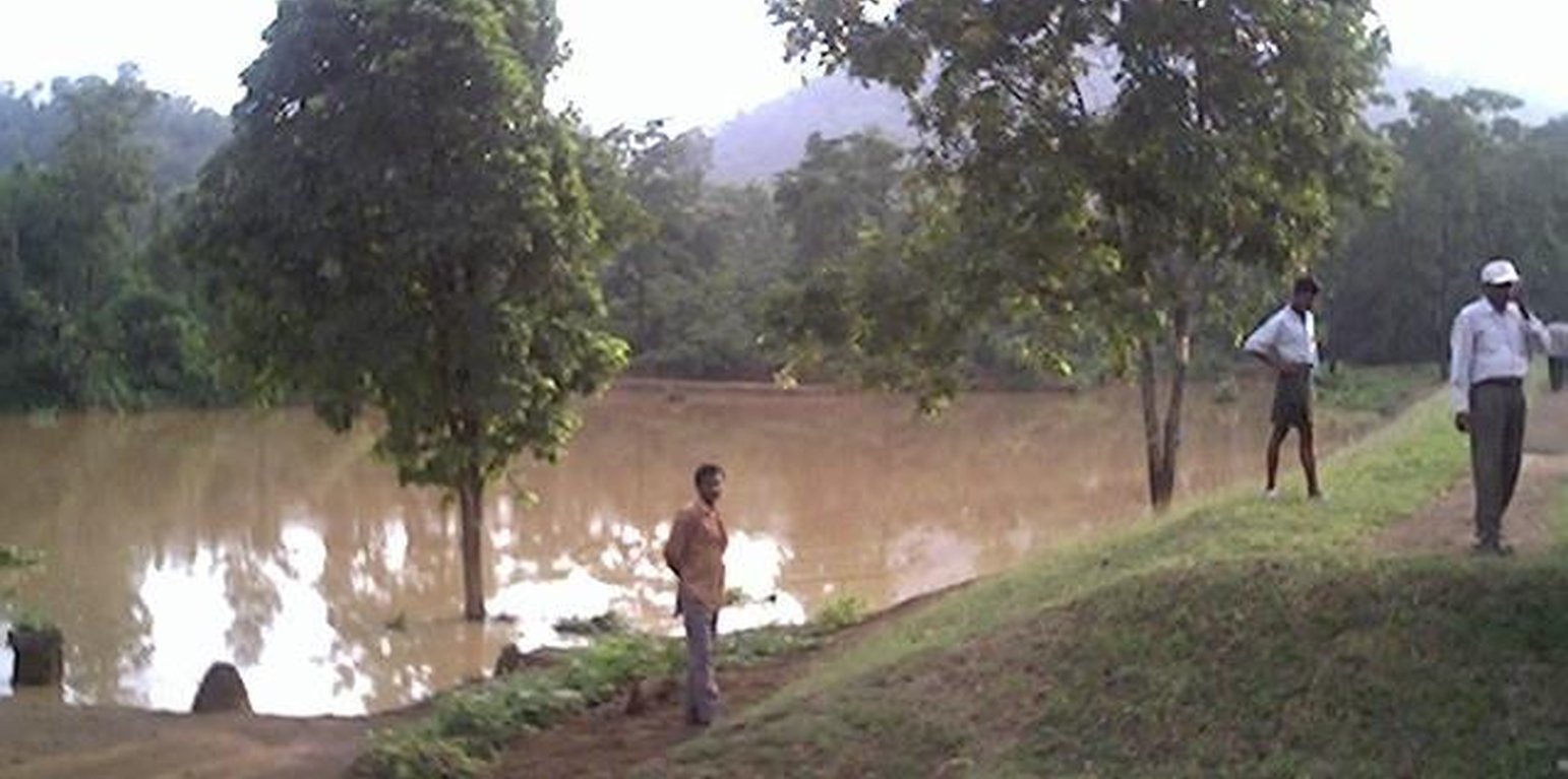
The area is located at the foot-slopes & hill slopes area where run-off is at peaks very often at the time of rainy season. Therefore, sand casting came as a first order priorities by the farmers of this patch. At the outset, a livelihood focused micro-plan had been prepared by the villagers stating the details of the base-line data along with problems & alternative solutions. The patch was identified to be the worst affected, concentraton of poor people (defined by villagers), people of this patch ready to contibute at least 20% of the cost. In the mean time project sent the PIA to BAIF, Bangalore to study the linking of farm ponds & its relevance in this context of our situation. As a demonstration, PIA & other technical team facilitated the villagers. One water harvesting structure was constructed by line deptt of soil conservation just at the down hills to harvest rain water & protect the lands below from sand casting. But there were no alternatives for the land users of that patch about the optimum utilisation recharged water. The surrounding area was totally unbunded with sandy loam soil. Therefore, land users are of opinion to go fo field bunding. Earlier the practice was to dig a trench at upper gadient & put a bund below it out of the excavated soil from trench. But the requirement of land users was to get some water in each farmers land to protect the Kharif & some early rabi crop.(june-dec). By which the lands where, farmers take up only minor millets for their subsistance, that too less production & land So the main purpose of this technology was to convert the land into bunded lands along with to fetch some water at the time of dry spell in between the monsoon period. A four days in field training was conducted by the project to community link workers(SWC), particularly on patch treatment, use of levelling instruments like A-frame, proper planning, design, lay-out of different type of structure in a map & ground. After many rounds of discussion with the land users, one of them ( rich farmers with more land) was ready to do it in his own land. But, the SWC specialist did a detail transact along with land users, although results of first round tansact was mentioned in the micro-plan. The main pupose was to looking at problems & demarkating on the map. After that estimate was prepared & lay-out of key contour was done by SWC specialist with the help of community link workers & land users. The work was implemented by by the labourers with the supervision of the respective User's group leade & monitoring was done by the SWC specialist. The prioty ranking by the land users vegetaive measures like vertiver & Sabai (grass plantation on the bund along the side of the bund. For that, the necessary requirement like nursery, seedling collection was done by agriculture specialist. Training was conducted on the probable alternatives of agronomic measures like taking of crop which is of little longer duration, intercrops & cash crops etc. The vegetaive & structructural measures are subsidised by the project & the agronomic measures was taken up on loan basis. The development fund was also generated out of contribution from the land users which was deposited in a separate account for future maintainance cost.

Lieu

Lieu: Khaparakhol, Orissa, Inde

Nbr de sites de la Technologie analysés:

Géo-référence des sites sélectionnés
  • 83.8132, 21.0511

Diffusion de la Technologie: répartie uniformément sur une zone (0.7 km²)

Dans des zones protégées en permanence ?:

Date de mise en oeuvre: il y a moins de 10 ans (récemment)

Type d'introduction
-
COTTON

Classification de la Technologie

Principal objectif
  • améliorer la production
  • réduire, prévenir, restaurer les terres dégradées
  • préserver l'écosystème
  • protéger un bassin versant/ des zones situées en aval - en combinaison avec d'autres technologies
  • conserver/ améliorer la biodiversité
  • réduire les risques de catastrophes
  • s'adapter au changement et aux extrêmes climatiques et à leurs impacts
  • atténuer le changement climatique et ses impacts
  • créer un impact économique positif
  • créer un impact social positif
L'utilisation des terres
Les divers types d'utilisation des terres au sein du même unité de terrain: Oui - Agro-sylvo-pastoralisme

  • Terres cultivées
    • Cultures annuelles: céréales - mil, céréales - riz (de milieux secs), cultures de plantes à fibres - coton, cultures oléagineuses - arachide, rice
    • Plantations d’arbres ou de buissons: manguier, mangostane, goyave, fruits à pépins (pommes, poires, coings, etc.)
    Nombre de période de croissance par an: : 2
  • Pâturages
Approvisionnement en eau
  • pluvial
  • mixte: pluvial-irrigué
  • pleine irrigation

But relatif à la dégradation des terres
  • prévenir la dégradation des terres
  • réduire la dégradation des terres
  • restaurer/ réhabiliter des terres sévèrement dégradées
  • s'adapter à la dégradation des terres
  • non applicable
Dégradation des terres traité
  • érosion hydrique des sols - Wt: perte de la couche superficielle des sols (couche arable)/ érosion de surface, Wg: ravinement/ érosion en ravines, Wm: mouvements de masse/ glissements de terrain, Wo: effets hors-site de la dégradation
Groupe de GDT
  • mesures en travers de la pente
  • récupération/ collecte de l'eau
Mesures de GDT
  • pratiques végétales -
  • structures physiques -

Dessin technique

Spécifications techniques

Mise en œuvre et entretien : activités, intrants et coûts

Calcul des intrants et des coûts
  • Les coûts sont calculés :
  • Monnaie utilisée pour le calcul des coûts : Rupee
  • Taux de change (en dollars américains - USD) : 1 USD = 50.0 Rupee
  • Coût salarial moyen de la main-d'oeuvre par jour : n.d.
Facteurs les plus importants affectant les coûts
Soil depth is very less, hard soil with slope variation because of undulating lands. The labour was also not sufficiently available at the time of establishment, because the work was implemented at time of main growing season. At that time land users are busy in their own field because of cultivation work.
Activités de mise en place/ d'établissement
  1. Survey & alignment of key Contour & lay-out of tanks (Calendrier/ fréquence: Beginning of rainy season)
  2. Digging of pits for grass, fruit plants & timber (Calendrier/ fréquence: June)
  3. Collection of Vertiver & Sabai grass from external source (Calendrier/ fréquence: july)
  4. Collection of seedling of Trees/Plants (Calendrier/ fréquence: July)
  5. Survey & contour demarkation (Calendrier/ fréquence: April-May)
  6. Demarkation on map (Calendrier/ fréquence: April-May)
  7. Estimate & lay-Out (Calendrier/ fréquence: April-May)
  8. Implementation of work (Calendrier/ fréquence: June)
  9. Survey & Key Contour line demarkation at 75 ft interval (Calendrier/ fréquence: June)
  10. Digging of Sunken ponds (Calendrier/ fréquence: July)
  11. Top level dressing of bund (Calendrier/ fréquence: July)
  12. Water-way with connection Dug-out sunken ponds (Calendrier/ fréquence: August)
Intrants et coûts de mise en place
Spécifiez les intrants Unité Quantité Coûts par unité (Rupee) Coût total par intrant (Rupee) % des coût supporté par les exploitants des terres
Main d'œuvre
Labour ha 1,0 90,0 90,0 20,0
Equipements
Animal traction ha 1,0 5,0 5,0 20,0
Matériel végétal
Seedlings ha 1,0 25,0 25,0
Coût total de mise en place de la Technologie 120.0
Coût total de mise en place de la Technologie en dollars américains (USD) 2.4
Activités récurrentes d'entretien
  1. Ploughing (Calendrier/ fréquence: April-May / annual)
  2. Intercultural operation with manure application (Calendrier/ fréquence: June / annual)
  3. Sowing (Calendrier/ fréquence: July & sep for two crops / each cropping season)
  4. weeding & intercultural operation, if required. (Calendrier/ fréquence: July / annual)
  5. Harvesting of paddy or minor millets or ground nut (Calendrier/ fréquence: Aug-sep / annual)
  6. Sowing of pulses as relay crop (Calendrier/ fréquence: Aug-sep / each cropping season)
  7. Harvesting of pulses (Calendrier/ fréquence: Nov-Dec / each cropping season)
  8. Collapsing of bunds may damage th evegetation (Calendrier/ fréquence: Rainy Season /annual)
  9. Checking against free grazing (Calendrier/ fréquence: Jan-June /)
  10. Watering to plants (Calendrier/ fréquence: Dec-May /annual)
  11. Management of surplus water (Calendrier/ fréquence: Rainy Season/Once in Year)
  12. Collapsing of bund (Calendrier/ fréquence: None)
  13. Tanks must be desilted (Calendrier/ fréquence: Dry season/Once in Year)
  14. Control of surplus water-flow (Calendrier/ fréquence: Rainy season / once a year)
  15. Stabilisation of bund at weak points (Calendrier/ fréquence: August / once a year)
  16. Desiltation of ponds (Calendrier/ fréquence: None)
Intrants et coûts de l'entretien
Spécifiez les intrants Unité Quantité Coûts par unité (Rupee) Coût total par intrant (Rupee) % des coût supporté par les exploitants des terres
Main d'œuvre
Labour ha 1,0 4,0 4,0 100,0
Matériel végétal
Seedlings ha 1,0 3,0 3,0 100,0
Coût total d'entretien de la Technologie 7.0
Coût total d'entretien de la Technologie en dollars américains (USD) 0.14

Environnement naturel

Précipitations annuelles
  • < 250 mm
  • 251-500 mm
  • 501-750 mm
  • 751-1000 mm
  • 1001-1500 mm
  • 1501-2000 mm
  • 2001-3000 mm
  • 3001-4000 mm
  • > 4000 mm
Zones agro-climatiques
  • humide
  • subhumide
  • semi-aride
  • aride
Spécifications sur le climat
1000-1500 mm: Ranked 1, Avg rainfall from liz kiff report. The study of 20 years of rainfall data shows that, drought comes in every alternative 3 years. The rainfall varies from a minimum of 715.6 mm to maximum of 1863 mm
500-750 mm: Ranked 2
1500-2000 mm: Ranked 3
Pentes moyennes
  • plat (0-2 %)
  • faible (3-5%)
  • modéré (6-10%)
  • onduleux (11-15%)
  • vallonné (16-30%)
  • raide (31-60%)
  • très raide (>60%)
Reliefs
  • plateaux/ plaines
  • crêtes
  • flancs/ pentes de montagne
  • flancs/ pentes de colline
  • piémonts/ glacis (bas de pente)
  • fonds de vallée/bas-fonds
Zones altitudinales
  • 0-100 m
  • 101-500 m
  • 501-1000 m
  • 1001-1500 m
  • 1501-2000 m
  • 2001-2500 m
  • 2501-3000 m
  • 3001-4000 m
  • > 4000 m
La Technologie est appliquée dans
  • situations convexes
  • situations concaves
  • non pertinent
Profondeurs moyennes du sol
  • très superficiel (0-20 cm)
  • superficiel (21-50 cm)
  • modérément profond (51-80 cm)
  • profond (81-120 cm)
  • très profond (>120 cm)
Textures du sol (de la couche arable)
  • grossier/ léger (sablonneux)
  • moyen (limoneux)
  • fin/ lourd (argile)
Textures du sol (> 20 cm sous la surface)
  • grossier/ léger (sablonneux)
  • moyen (limoneux)
  • fin/ lourd (argile)
Matière organique de la couche arable
  • abondant (>3%)
  • moyen (1-3%)
  • faible (<1%)
Profondeur estimée de l’eau dans le sol
  • en surface
  • < 5 m
  • 5-50 m
  • > 50 m
Disponibilité de l’eau de surface
  • excès
  • bonne
  • moyenne
  • faible/ absente
Qualité de l’eau (non traitée)
  • eau potable
  • faiblement potable (traitement nécessaire)
  • uniquement pour usage agricole (irrigation)
  • eau inutilisable
La salinité de l'eau est-elle un problème ?
  • Oui
  • Non

Présence d'inondations
  • Oui
  • Non
Diversité des espèces
  • élevé
  • moyenne
  • faible
Diversité des habitats
  • élevé
  • moyenne
  • faible

Caractéristiques des exploitants des terres appliquant la Technologie

Orientation du système de production
  • subsistance (auto-approvisionnement)
  • exploitation mixte (de subsistance/ commerciale)
  • commercial/ de marché
Revenus hors exploitation
  • moins de 10% de tous les revenus
  • 10-50% de tous les revenus
  • > 50% de tous les revenus
Niveau relatif de richesse
  • très pauvre
  • pauvre
  • moyen
  • riche
  • très riche
Niveau de mécanisation
  • travail manuel
  • traction animale
  • mécanisé/ motorisé
Sédentaire ou nomade
  • Sédentaire
  • Semi-nomade
  • Nomade
Individus ou groupes
  • individu/ ménage
  • groupe/ communauté
  • coopérative
  • employé (entreprise, gouvernement)
Genre
  • femmes
  • hommes
Âge
  • enfants
  • jeunes
  • personnes d'âge moyen
  • personnes âgées
Superficie utilisée par ménage
  • < 0,5 ha
  • 0,5-1 ha
  • 1-2 ha
  • 2-5 ha
  • 5-15 ha
  • 15-50 ha
  • 50-100 ha
  • 100-500 ha
  • 500-1 000 ha
  • 1 000-10 000 ha
  • > 10 000 ha
Échelle
  • petite dimension
  • moyenne dimension
  • grande dimension
Propriété foncière
  • état
  • entreprise
  • communauté/ village
  • groupe
  • individu, sans titre de propriété
  • individu, avec titre de propriété
Droits d’utilisation des terres
  • accès libre (non organisé)
  • communautaire (organisé)
  • loué
  • individuel
Droits d’utilisation de l’eau
  • accès libre (non organisé)
  • communautaire (organisé)
  • loué
  • individuel
Accès aux services et aux infrastructures

Impact

Impacts socio-économiques
Production agricole
en baisse
x
en augmentation


Per hac production/economic cost.

production fourragère
en baisse
x
en augmentation


Vertiver as fodder on bund.

qualité des fourrages
en baisse
x
en augmentation


Vertiver as fodder on bund.

production de bois
en baisse
x
en augmentation


Teak plants has been planted this year. The yeild is yet to come.

surface de production (nouvelles terres cultivées/ utilisées)
en baisse
x
en augmentation


Land users believe that some land is wastage due the structure.

gestion des terres
entravé
x
simplifié


Ploughing operation.

revenus agricoles
en baisse
x
en augmentation


Resource rich & resource poor land users accrued double benefit by changing the crop.

diversité des sources de revenus
en baisse
x
en augmentation


Farm employment at lean period. Income through labour

Field Demonstration- living institution
decreased
x
increased


Alternatives to mitigate drought.

Impacts socioculturels
institutions communautaires
affaibli
x
renforcé


Contribution labour from land users because of convincing benefit from the technology. The women also contributed in plantation activities.

institutions nationales
affaibli
x
renforcé


Members from other areas of district also learnt the technology through exposure visit.

connaissances sur la GDT/ dégradation des terres
réduit
x
amélioré


Some of the land users of other patch of the village decided to take up similar activity.

situation des groupes socialement et économiquement désavantagés (genre, âge, statut, ethnie, etc.)
détérioré
x
amélioré


Land users having land below 1 hac are getting more benefit out this technology.

Impacts écologiques
ruissellement de surface
en augmentation
x
en baisse

Quantité avant la GDT: 50
Quantité après la GDT: 10

drainage de l'excès d'eau
réduit
x
amélioré


Earthen hume pipes.

humidité du sol
en baisse
x
en augmentation


This condition help the land users to take up second crop.

couverture du sol
réduit
x
amélioré


Particularly top-soil.

perte en sol
en augmentation
x
en baisse

Quantité avant la GDT: 30
Quantité après la GDT: 20

diversité végétale
en baisse
x
en augmentation

diversité animale
en baisse
x
en augmentation

diversité des habitats
en baisse
x
en augmentation

Soil fertility
decreased
x
increased


Production/ Economic benefit becomes double.

Water availability in dry spell
decreased
x
increased

Impacts hors site
flux des cours d'eau fiables et stables en saison sèche (incl. faibles débits)
réduit
x
en augmentation

inondations en aval (indésirables)
en augmentation
x
réduit

envasement en aval
en augmentation
x
en baisse

Analyse coûts-bénéfices

Bénéfices par rapport aux coûts de mise en place
Rentabilité à court terme
très négative
x
très positive

Rentabilité à long terme
très négative
x
très positive

Bénéfices par rapport aux coûts d'entretien
Rentabilité à court terme
très négative
x
très positive

Rentabilité à long terme
très négative
x
très positive

Changement climatique

-

Adoption et adaptation de la Technologie

Pourcentage d'exploitants des terres ayant adopté la Technologie dans la région
  • cas isolés/ expérimentaux
  • 1-10%
  • 11-50%
  • > 50%
Parmi tous ceux qui ont adopté la Technologie, combien d'entre eux l'ont fait spontanément, à savoir sans recevoir aucune incitation matérielle ou aucun paiement ?
  • 0-10%
  • 11-50%
  • 51-90%
  • 91-100%
Nombre de ménages et/ou superficie couverte
19
La Technologie a-t-elle été récemment modifiée pour s'adapter à l'évolution des conditions ?
  • Oui
  • Non
A quel changement ?
  • changements/ extrêmes climatiques
  • évolution des marchés
  • la disponibilité de la main-d'œuvre (par ex., en raison de migrations)

Conclusions et enseignements tirés

Points forts: point de vue de l'exploitant des terres
  • Maintainance is very less

    How can they be sustained / enhanced? Only timely care is needed.
  • Land users can have water in their field other than rain water to be used for different purpose.

    How can they be sustained / enhanced? Some demos agriculture was done in this patch which has to be repeated for the second year for confidence building of the land users.
Points forts: point de vue du compilateur ou d'une autre personne-ressource clé
  • Water availability in the dry spell

    How can they be sustained / enhanced? If the land users will desilt the pond timely & care to plants grass on the bund.
  • The land where only one crop is possible, vegetable & pulse crop can be taken up as second crop

    How can they be sustained / enhanced? Some methodology is to be applied to keep water in the pond for longer duration.
Faiblesses/ inconvénients/ risques: point de vue de l'exploitant des terrescomment surmonter
  • Ploughing operation will be difficult. This is although difficult but th benefit is more, therefore land users will compromise with this type of difficulty.
  • Water availability in dry period & desiltaion process. This can be overcomed by planting vertiver on the sides of the pond & low cost polythene can be used for prolonging percolation rate of water in sandy loam soil.
Faiblesses/ inconvénients/ risques: point de vue du compilateur ou d'une autre personne-ressource clécomment surmonter
  • The farmers started taking up cotton & paddy in stead of minor millets Improved variety of minor millets is supplied to farmers for better yield in comparison to country variety.
  • Diversion of surplus water The land users have to dig atleast one more feet & earthen pipes will be used for the diversion of surplus water.

Références

Compilateur
  • Unknown User
Editors
Examinateur
  • Fabian Ottiger
  • Alexandra Gavilano
Date de mise en oeuvre: 3 juin 2011
Dernière mise à jour: 4 avril 2019
Personnes-ressources
Description complète dans la base de données WOCAT
Données de GDT correspondantes
La documentation a été facilitée par
Institution Projet
This work is licensed under Creative Commons Attribution-NonCommercial-ShareaAlike 4.0 International