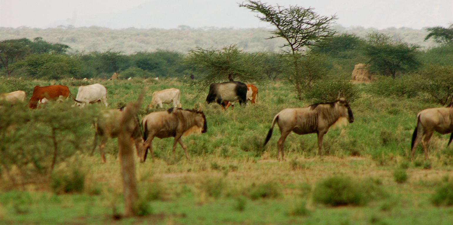
Wildebeest and livestock grazing in the wet season in the grazing area (Guy Western)

Ecosystem-wide seasonal grazing management in community land (Kenya)

Description

Livestock movements are managed through community governance systems to maintain spatial and temporal heterogeneity of pasture, creating a gradient of quality and quantity of pasture across the landscape. This is achieved through clearly designated seasonal grazing areas for livestock and tight controls on settlement areas, grazing patterns and water points. In addition, at the individual herder level, traditional ecological knowledge plays a strong role in the decisions made to improve livestock production

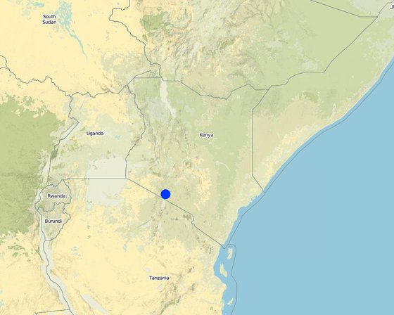
This technology is applied in the South Rift Valley, Kenya, across a semi-arid landscape, with erratic rainfall averaging 400-600 mm per annum. Water availability is an issue. The perennial Ewaso Ngiro South river flows through the Shompole swamp, a vital drought refuge for livestock and wildlife, before ending up in Lake Natron. The area, roughly 1000 km2, is covered by two group ranches, Olkiramatian and Shompole, which are managed as a single ecological unit. A group ranch is a jointly owned freehold land title given to the customary occupants of communal lands. The total number of occupants of both ranches number roughly 20,000 people, with the majority belonging to the Maasai ethnic group. The ranches have not been subdivided and are not fully sedentary, unlike many other areas of southern Kenya.
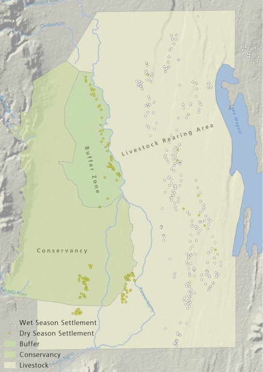
There is a long history of co-existence of wildlife and livestock in Maasialand. In Olkiramatian and Shompole seasonal livestock movements and herding practices are formalized by group ranch grazing plans governed by local committees. The wet season grazing areas are termed “livestock rearing zones”. The dry season grazing areas have been retained as “grass banks” for livestock, and since the early 2000s, have been used additionally as wildlife conservancies for ecotourism (see figure below). Livestock rearing occurs to the east of the Ewaso Ngiro river; grass banks and the wildlife conservancy to the west. Grazing committees from both group ranches manage livestock access to certain areas, with the conservancy (grass bank) rested during the wet season of up to six months. When grazing is permitted in the conservancy, as the dry season progresses, temporary settlements are limited to an area called the “buffer zone”. Livestock must then move into the conservancy from the buffer zones to access this late season grazing. The “livestock rearing zone” is permanently settled and grazed year-round. Within each zone there are small “Olopololis” (grass banks of a few hectares), situated near individual settlements and used to maintain higher quality pasture for weak and young animals. This management strategy ensures that the dry season grazing area is rested during the rains, and it helps to maintain consistently higher biomass and taller grass than that of the wet season grazing area. The higher biomass also corresponds to a rainfall gradient running from the Nguruman Escarpment edge in the western extremity of the group ranches to the dry central rift valley floor in the east. The biomass in the dry season area is used by both livestock and wildlife grazers during the late dry season and in droughts. The grass bank is only grazed out during prolonged dry periods. The Maasai employ a strategy of using the shorter milk-producing grasses of the livestock areas during the rains and the coarser grasses in the grass banks for the dry seasons. The shorter wet season pastures have a higher nutrient content and greater digestibility than the grass bank: this is very important for lactating females. The grass is kept short from both grazing by livestock during the growing seasons and due to intrinsic differences caused by shallower soils and lower rainfall in these grazing areas.
Within this broader governance framework and control of grazing areas, individual decision making is also permitted within these controlled areas. This allows herders to manage livestock to improve production in relation to each herd. For example, individuals might split the herd to take advantage of different energy and nutrient requirements of lactating females, bulls, and calves.
This maintenance and exploitation of forage heterogeneity is vital to the productivity and resilience of the landscape, and this heterogeneity exists at multiple scales, with the major differences existing between the grazing areas, but also smaller difference within them. Resource heterogeneity facilitates wildlife-livestock coexistence. This heterogeneity creates a matrix of varying quality and quantity of forage. Wildlife species have different metabolic requirements and diets, and this varied base ensures that a diverse wild ungulate population is maintained year-round. Late season forage boosts the resilience of wildlife during extreme events. This technology requires a governance structure that is both responsive to the changing ecological conditions and able to build consensus and enforce grazing management.

Lieu

Lieu: Olkiramatian, Kajiado, Kenya

Nbr de sites de la Technologie analysés: site unique

Géo-référence des sites sélectionnés
  • 36.14942, -1.86005

Diffusion de la Technologie: répartie uniformément sur une zone (approx. 100-1 000 km2)

Dans des zones protégées en permanence ?:

Date de mise en oeuvre: 2004

Type d'introduction

Classification de la Technologie

Principal objectif
  • améliorer la production
  • réduire, prévenir, restaurer les terres dégradées
  • préserver l'écosystème
  • protéger un bassin versant/ des zones situées en aval - en combinaison avec d'autres technologies
  • conserver/ améliorer la biodiversité
  • réduire les risques de catastrophes
  • s'adapter au changement et aux extrêmes climatiques et à leurs impacts
  • atténuer le changement climatique et ses impacts
  • créer un impact économique positif
  • créer un impact social positif
L'utilisation des terres

  • Pâturages
    • Pastoralisme de type semi-nomade
    Type d'animal: caprine, ovins, cattle
Approvisionnement en eau
  • pluvial
  • mixte: pluvial-irrigué
  • pleine irrigation

But relatif à la dégradation des terres
  • prévenir la dégradation des terres
  • réduire la dégradation des terres
  • restaurer/ réhabiliter des terres sévèrement dégradées
  • s'adapter à la dégradation des terres
  • non applicable
Dégradation des terres traité
  • érosion hydrique des sols - Wt: perte de la couche superficielle des sols (couche arable)/ érosion de surface
  • dégradation biologique - Bc: réduction de la couverture végétale, Bh: perte d’habitats, Bq: baisse de la quantité/ biomasse, Bs: baisse de la qualité et de la composition/ diversité des espèces
Groupe de GDT
  • pastoralisme et gestion des pâturages
Mesures de GDT
  • modes de gestion - M2: Changement du niveau de gestion / d'intensification, M3: Disposition/plan en fonction de l'environnement naturel et humain , M4: Changement majeur dans le calendrier des activités

Dessin technique

Spécifications techniques
The drawing shows the management units used in this seasonally structured grazing management system. The livestock rearing zone, to the east of the Ewaso Nyiro river, is permanently settled and is grazed heavily during the wet season (April - July). During this time herders utilize the short, nutritious grasses in this low biomass area. As forage biomass begins to reduce the community grazing committees meet to discuss the opening of settlements to the west of the Ewaso Nyiro river. This decision is made using traditional ecological knowledge, comparing available forage biomass and the numbers of livestock to previous years and past experiences. Once the grazing has been opened to the west of the river people may settle within the buffer zone. This limits direct access to the higher biomass areas within the conservancy and grass banks, and increases the length of travel for each herd every day, in an effort to preserve forage for longer. Once forage has been depleted in the buffer zones and the periphery of the conservancies, the committees meet and allow access for herders into the conservation areas, which have tall, high biomass, but low-quality grazing. Often access to this area requires considerable distances to be walked by livestock. In recent years, adaptive management systems have led to the settlements within the south of the conservation area to be closed to preserve forage biomass within the swamp and conservation area for a longer period of time; and allow for recovery of partially degraded land.
Author: Peter Tyrrell

Mise en œuvre et entretien : activités, intrants et coûts

Calcul des intrants et des coûts
  • Les coûts sont calculés : par entité de la Technologie (unité : The two group ranches volume, length: Approximately 1000km2)
  • Monnaie utilisée pour le calcul des coûts : dollars américains
  • Taux de change (en dollars américains - USD) : 1 USD = n.d.
  • Coût salarial moyen de la main-d'oeuvre par jour : 4
Facteurs les plus importants affectant les coûts
There are no or little costs to this technology, as it builds off structures of management which are already in place and work organically within the area.
Activités de mise en place/ d'établissement
n.a.
Activités récurrentes d'entretien
  1. Management meetings (Calendrier/ fréquence: Seasonally)

Environnement naturel

Précipitations annuelles
  • < 250 mm
  • 251-500 mm
  • 501-750 mm
  • 751-1000 mm
  • 1001-1500 mm
  • 1501-2000 mm
  • 2001-3000 mm
  • 3001-4000 mm
  • > 4000 mm
Zones agro-climatiques
  • humide
  • subhumide
  • semi-aride
  • aride
Spécifications sur le climat
Précipitations moyennes annuelles en mm : 400.0
Highly variable rainfall both spatially and temporally. Annual average rainfall has a 33%CV.
Nom de la station météorologique : Lale'enok Resource Centre
Pentes moyennes
  • plat (0-2 %)
  • faible (3-5%)
  • modéré (6-10%)
  • onduleux (11-15%)
  • vallonné (16-30%)
  • raide (31-60%)
  • très raide (>60%)
Reliefs
  • plateaux/ plaines
  • crêtes
  • flancs/ pentes de montagne
  • flancs/ pentes de colline
  • piémonts/ glacis (bas de pente)
  • fonds de vallée/bas-fonds
Zones altitudinales
  • 0-100 m
  • 101-500 m
  • 501-1000 m
  • 1001-1500 m
  • 1501-2000 m
  • 2001-2500 m
  • 2501-3000 m
  • 3001-4000 m
  • > 4000 m
La Technologie est appliquée dans
  • situations convexes
  • situations concaves
  • non pertinent
Profondeurs moyennes du sol
  • très superficiel (0-20 cm)
  • superficiel (21-50 cm)
  • modérément profond (51-80 cm)
  • profond (81-120 cm)
  • très profond (>120 cm)
Textures du sol (de la couche arable)
  • grossier/ léger (sablonneux)
  • moyen (limoneux)
  • fin/ lourd (argile)
Textures du sol (> 20 cm sous la surface)
  • grossier/ léger (sablonneux)
  • moyen (limoneux)
  • fin/ lourd (argile)
Matière organique de la couche arable
  • abondant (>3%)
  • moyen (1-3%)
  • faible (<1%)
Profondeur estimée de l’eau dans le sol
  • en surface
  • < 5 m
  • 5-50 m
  • > 50 m
Disponibilité de l’eau de surface
  • excès
  • bonne
  • moyenne
  • faible/ absente
Qualité de l’eau (non traitée)
  • eau potable
  • faiblement potable (traitement nécessaire)
  • uniquement pour usage agricole (irrigation)
  • eau inutilisable
La qualité de l'eau fait référence à:
La salinité de l'eau est-elle un problème ?
  • Oui
  • Non

Présence d'inondations
  • Oui
  • Non
Diversité des espèces
  • élevé
  • moyenne
  • faible
Diversité des habitats
  • élevé
  • moyenne
  • faible

Caractéristiques des exploitants des terres appliquant la Technologie

Orientation du système de production
  • subsistance (auto-approvisionnement)
  • exploitation mixte (de subsistance/ commerciale)
  • commercial/ de marché
Revenus hors exploitation
  • moins de 10% de tous les revenus
  • 10-50% de tous les revenus
  • > 50% de tous les revenus
Niveau relatif de richesse
  • très pauvre
  • pauvre
  • moyen
  • riche
  • très riche
Niveau de mécanisation
  • travail manuel
  • traction animale
  • mécanisé/ motorisé
Sédentaire ou nomade
  • Sédentaire
  • Semi-nomade
  • Nomade
Individus ou groupes
  • individu/ ménage
  • groupe/ communauté
  • coopérative
  • employé (entreprise, gouvernement)
Genre
  • femmes
  • hommes
Âge
  • enfants
  • jeunes
  • personnes d'âge moyen
  • personnes âgées
Superficie utilisée par ménage
  • < 0,5 ha
  • 0,5-1 ha
  • 1-2 ha
  • 2-5 ha
  • 5-15 ha
  • 15-50 ha
  • 50-100 ha
  • 100-500 ha
  • 500-1 000 ha
  • 1 000-10 000 ha
  • > 10 000 ha
Échelle
  • petite dimension
  • moyenne dimension
  • grande dimension
Propriété foncière
  • état
  • entreprise
  • communauté/ village
  • groupe
  • individu, sans titre de propriété
  • individu, avec titre de propriété
Droits d’utilisation des terres
  • accès libre (non organisé)
  • communautaire (organisé)
  • loué
  • individuel
Droits d’utilisation de l’eau
  • accès libre (non organisé)
  • communautaire (organisé)
  • loué
  • individuel
  • Traditional methods of water management through comittees exists in some areas. In other area the creation of Water Resource Users Associations has begun to manage water.
Accès aux services et aux infrastructures
santé

pauvre
x
bonne
éducation

pauvre
x
bonne
assistance technique

pauvre
x
bonne
emploi (par ex. hors exploitation)

pauvre
x
bonne
marchés

pauvre
x
bonne
énergie

pauvre
x
bonne
routes et transports

pauvre
x
bonne
eau potable et assainissement

pauvre
x
bonne
services financiers

pauvre
x
bonne

Impact

Impacts socio-économiques
production fourragère
en baisse
x
en augmentation


This is in contrast to areas without seasonal grazing management.

qualité des fourrages
en baisse
x
en augmentation


This management system works best to preserve lower quality higher biomass fodder. Quality may not increase dramatically, but the creation of short areas of well-fertilized grass near settlements may increase the local quality of fodder during the wet season.

risque d'échec de la production
en augmentation
x
en baisse


In comparison to other systems the preservation of late season grazing is crucial in preventing complete losses of livestock during droughts.

Impacts socioculturels
opportunités culturelles (spirituelles, religieuses, esthétiques, etc.)
réduit
x
amélioré


Management of land in this manner relies on traditional ecological knowledge for both individual and community decision making. This is dependent on cultural values and understanding, and underpins grazing management in Maasai society.

Impacts écologiques
couverture végétale
en baisse
x
en augmentation


This method increase vegetation cover by maintaining heterogeneity of forage resources across the landscape, and resting pasture seasonally to allow for vegetation regrowth.

biomasse/ au dessus du sol C
en baisse
x
en augmentation


Late season forage available. Recovery and rest allows for greater productivity and rainfall use efficiency.

diversité animale
en baisse
x
en augmentation


Maintenance of spatial and temporal heterogeneity of forage resources ensures that wildlife species have access to the variable resources that they require over time.

Impacts hors site

Analyse coûts-bénéfices

Bénéfices par rapport aux coûts de mise en place
Rentabilité à court terme
très négative
x
très positive

Rentabilité à long terme
très négative
x
très positive

Bénéfices par rapport aux coûts d'entretien
Rentabilité à court terme
très négative
x
très positive

Rentabilité à long terme
très négative
x
très positive

No costs to establish and low direct cost of management actions.

Changement climatique

Changements climatiques progressifs
précipitations annuelles décroît

pas bien du tout
x
très bien
précipitations saisonnières décroît

pas bien du tout
x
très bien
Saison: saison des pluies/ humide
Extrêmes climatiques (catastrophes)
sécheresse

pas bien du tout
x
très bien

Adoption et adaptation de la Technologie

Pourcentage d'exploitants des terres ayant adopté la Technologie dans la région
  • cas isolés/ expérimentaux
  • 1-10%
  • 11-50%
  • > 50%
Parmi tous ceux qui ont adopté la Technologie, combien d'entre eux l'ont fait spontanément, à savoir sans recevoir aucune incitation matérielle ou aucun paiement ?
  • 0-10%
  • 11-50%
  • 51-90%
  • 91-100%
La Technologie a-t-elle été récemment modifiée pour s'adapter à l'évolution des conditions ?
  • Oui
  • Non
A quel changement ?
  • changements/ extrêmes climatiques
  • évolution des marchés
  • la disponibilité de la main-d'œuvre (par ex., en raison de migrations)
The management is constantly being adapted based on the prevailing ecological conditions. In 2015, over fifty settlements were closed by the community grazing and group ranch committee within the dry season grazing area to allow for pasture regeneration and to consolidate preservation of the dry season grass bank.

Conclusions et enseignements tirés

Points forts: point de vue de l'exploitant des terres
  • This technology stems from a community based and is not imposed from a top-down perspective, and tries to create consensus among resource users.
  • Allows individual flexibility within the broader grazing structure so that people can manage livestock within their own objectives.
  • This technology provides forage for livestock into the dry season and drought.
Points forts: point de vue du compilateur ou d'une autre personne-ressource clé
  • Management in this way also replicates the methodologies used for land management for thousands of years by pastoral people and helps to generate an enabling environment for the coexistence of wildlife, domestic livestock, and people.
  • Ensures that pasture is rested during the growing season within the dry season grazing areas, so that root mass can be established and to ensure grass seed production.
Faiblesses/ inconvénients/ risques: point de vue de l'exploitant des terrescomment surmonter
  • Exploitation of the system by elites in charge of management decisions, allowing their livestock to access preferential grazing, which may not represent the needs of all groups. Ensure credible management structures in place; with the new community land act, this should encourage greater equity in decision making.
  • Preventing settlement in areas of traditional occupation by certain households.
Faiblesses/ inconvénients/ risques: point de vue du compilateur ou d'une autre personne-ressource clécomment surmonter
  • Lack of focus on a production based system and income generation through livestock sales. Create and enabling environment for change, through market improvement and learning exchanges.
  • Lack of resting and recovery of forage in the wet season grazing area. Rotate and rest wet season pasture for a few weeks during the growing period, potentially through grazing in the dry season reserve for a longer period.

Références

Compilateur
  • Peter Tyrrell
Editors
  • Enoch Mobisa
  • Lance W. Robinson
Examinateur
  • Donia Mühlematter
  • Hanspeter Liniger
  • Rima Mekdaschi Studer
  • Alexandra Gavilano
Date de mise en oeuvre: 1 février 2018
Dernière mise à jour: 7 juin 2019
Personnes-ressources
Description complète dans la base de données WOCAT
Données de GDT correspondantes
La documentation a été facilitée par
Institution Projet
Liens vers des informations pertinentes disponibles en ligne
This work is licensed under Creative Commons Attribution-NonCommercial-ShareaAlike 4.0 International