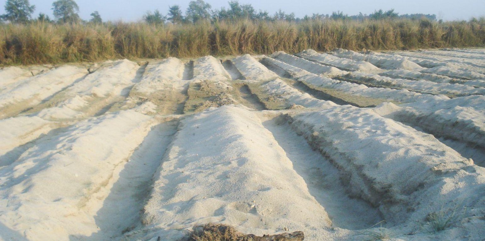
Land preparation for riverbed farming in Kailali District (Juerg Merz)
It is estimated that about 8,000 hectares of riverbed land would be suitable for agricultural cultivation in the Kailali and Kanchanpur Districts in the Western Terai areas of Nepal. After the river water recedes in the post-monsoon season, vegetables are planted in ditches dug into the seasonal sand banks; the crops are harvested before the onset of the next monsoon. In 2006, Elam Plus of HELVETAS Swiss Inter-cooperation Nepal, assessed local practices of riverbed farming and piloted an improved approach with 670 farmers, mostly from the indigenous Tharu community. During the first year they cultivated 43 hectares. Since the initial results indicated that riverbed farming could increase the target population’s income significantly, the programme was expanded from the initial two districts (Kailali and Kanchanpur) to two new districts (Banke, and Bardiya). The number of households was increased to 2000 in 2008 and 3165 in 2012 after the initiative won a Global Development Market Place award from the World Bank.
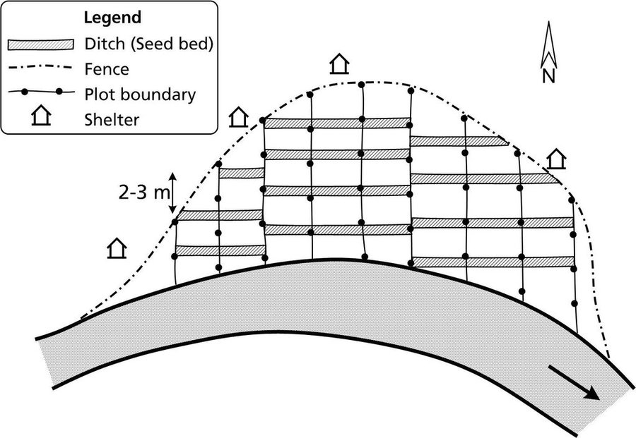
Establishment / maintenance activities and inputs: Requirements for riverbed farming:
• On average, the water table should not be lower than 1 m; when the water table is lower than this, too much labour is required.
• Plots are allocated perpendicular to the river flow in order to give each farmer access to a variety of land types (and moisture levels) suitable for different crops.
• Ditches are up to 1 m deep and 1 m wide. The length depends on how much land is available.
• A row-to-row spacing of 2–3 m (between the ditches) and plant-to-plant spacing of 0.5–1 m is required depending on the crop.
• The ditches are dug in an east-west orientation to maximize the amount of sunshine they receive and to minimise the collection of sand carried by the prevailing winds.
• Riverbed farmers can build shelters close to their plots so that they can be close at hand to fend off thieves and wild animals.
Lieu: Kanchanpur, Kailali Districts, Népal
Nbr de sites de la Technologie analysés:
Diffusion de la Technologie: répartie uniformément sur une zone (4.0 km²)
Dans des zones protégées en permanence ?:
Date de mise en oeuvre:
Type d'introduction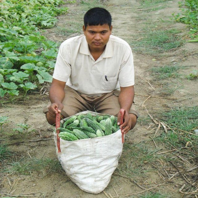


| Spécifiez les intrants | Unité | Quantité | Coûts par unité (dollars américains) | Coût total par intrant (dollars américains) | % des coût supporté par les exploitants des terres |
| Main d'œuvre | |||||
| Dig ditches and applying fertilizer and manure | ha | 1,0 | 232,0 | 232,0 | 100,0 |
| Equipements | |||||
| Sprayer, watering cans,spade | ha | 1,0 | 42,0 | 42,0 | |
| Engrais et biocides | |||||
| Seeds, chemical fertilizer | ha | 1,0 | 267,0 | 267,0 | |
| Matériaux de construction | |||||
| Plastic bags,mulching material | ha | 1,0 | 21,0 | 21,0 | |
| Coût total de mise en place de la Technologie | 562.0 | ||||
| Coût total de mise en place de la Technologie en dollars américains (USD) | 562.0 | ||||
| Spécifiez les intrants | Unité | Quantité | Coûts par unité (dollars américains) | Coût total par intrant (dollars américains) | % des coût supporté par les exploitants des terres |
| Main d'œuvre | |||||
| Maintaining plots | ha | 1,0 | 42,0 | 42,0 | 100,0 |
| Equipements | |||||
| Sprayer, watering cans,spade | ha | 1,0 | 28,0 | 28,0 | 25,0 |
| Engrais et biocides | |||||
| Seeds, chemical fertilizer | ha | 1,0 | 84,0 | 84,0 | 25,0 |
| Matériaux de construction | |||||
| Plastic bags, mulching material | ha | 1,0 | 11,0 | 11,0 | 50,0 |
| Coût total d'entretien de la Technologie | 165.0 | ||||
| Coût total d'entretien de la Technologie en dollars américains (USD) | 165.0 | ||||
Provides vegetables for riverbed farming households
Riverbed crops can be exchanged for food grain; on average,this can provide an additional four month
Conflicts can arise when the land is being allocated and border conflict can arise between different groups
Additional income can be used to cover school fees and health services
Provides alternative means of income as well as food security for landless and land-poor households
Excessive use of fertilizers may affect water quality and the use of pesticides in the case of massive pest invasions may affect the water quality as well
Minimize soil loss due to wind erosion
Crops can be lost during floods, cold spells and hailstormes


